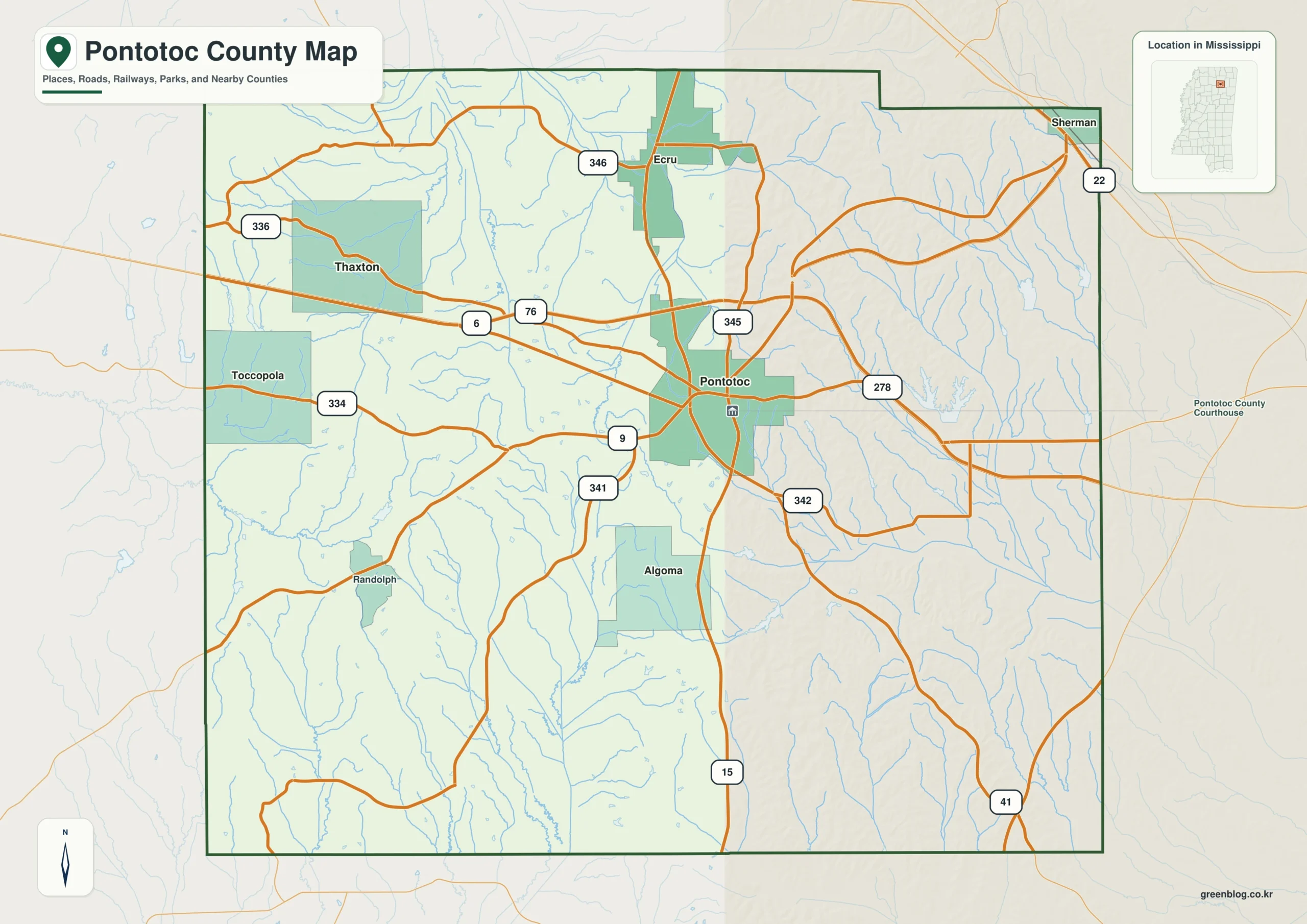
The Pontotoc County Mississippi map centers on Pontotoc and divides directions toward Ecru in the northwest, Thaxton in the west, Algoma in the south, and Sherman near the northeastern county junction. US 278/MS 6 and the Tanglefoot Trail offer different east-west and north-south ways to read the rolling countryside.
Pontotoc County Mississippi map download
The WebP preview is optimized for the page, while the button preserves the original high-resolution JPG for printing and reuse.
- File: County reference map
- Format: JPG
- Print layout: A3
Quick Facts
- State and identifier: Mississippi, Pontotoc County; FIPS 28115
- County seat: Pontotoc
- Selected map labels: Pontotoc, Ecru, Thaxton, Algoma, Sherman
- 2020 census population: 31,184
- July 2025 population estimate: 32,096
- 2025 Gazetteer area: 497.813 sq mi land and 3.208 sq mi water
- 2020 land-area density: 62.6 residents per sq mi
- Primary route references: US 278/MS 6, MS 15, MS 9, and MS 41
- Landscape references: Tanglefoot Trail, rolling northeastern hills, Little Tallahatchie tributaries, and wooded creek valleys
The decennial count and July 2025 estimate use different reference dates. Land and water measurements come from the 2025 Gazetteer. The density of 62.6 residents per square mile divides the 2020 population by 2025 land area and does not imply an even distribution among cities, farms, forest, or wetland.
Reading the Pontotoc County Mississippi map
US 278/MS 6 leads east from Pontotoc toward Lee County and west toward Lafayette County. MS 15 connects the Ecru side in the north with Algoma in the south, while Thaxton marks the west and Sherman the Lee-Union boundary area. Trail access points and every rural road are omitted.
Boundary, Water, and Terrain
Gentle hills and branching streams repeat across the county, with western tributaries entering the Little Tallahatchie system. The Tanglefoot Trail follows a former rail corridor through several communities. Ridges, creeks, and the reused rail alignment explain settlement more clearly than any dominant lake.
Measured together with Tanglefoot Trail and rolling northeastern hills, the county covers 501.021 square miles, with water representing approximately 0.6 percent. The placement of Tanglefoot Trail and rolling northeastern hills explains why the visual hierarchy depends on Pontotoc and Ecru. The approach toward Union is especially useful for distinguishing an edge connection from an internal route. Reducing local detail around Tanglefoot Trail and rolling northeastern hills prevents the principal geographic pattern from disappearing.
Settlement and Regional Context
Pontotoc is the administrative, retail, and manufacturing center. Ecru and Sherman also reflect access toward the Tupelo and New Albany areas. Furniture and other manufacturing employment adds a commuting pattern to the county's agricultural background. Pontotoc County’s July 2025 estimate exceeded the 2020 census figure by approximately 2.9 percent.
Practical Map Uses
- Orient US 278/MS 6 east and west of Pontotoc
- Compare Ecru and Algoma north and south
- Distinguish the Tanglefoot Trail from the highway network
Frequently Asked Questions
Is the Tanglefoot Trail a motor-vehicle road?
No. It is a nonmotorized recreation trail built on a former rail corridor and should be distinguished from ordinary highways.
How does Tanglefoot Trail complement Pontotoc when orienting the map toward Union?
A symbol at Pontotoc fixes one named point; Tanglefoot Trail adds a broader frame that can be followed toward Union without treating every local road as mapped.
Sources
- U.S. Census Bureau QuickFacts
- U.S. Census Bureau 2025 Gazetteer Files
- Mississippi Department of Transportation official highway map
- Regional landscape or institution reference
Related County Maps
Green Map creates custom-edited map images using open geographic data sources such as geoBoundaries, Natural Earth, OpenStreetMap, and government open data.
These maps are edited visual materials, not raw data files, and are provided for education, documents, presentations, and graphic reference.