The Neshoba County Mississippi map centers on Philadelphia and also identifies Union to the south together with the Choctaw and Pearl River community area. County government and communities of the Mississippi Band of Choctaw Indians occupy the same central-hills landscape near the upper Pearl River system.
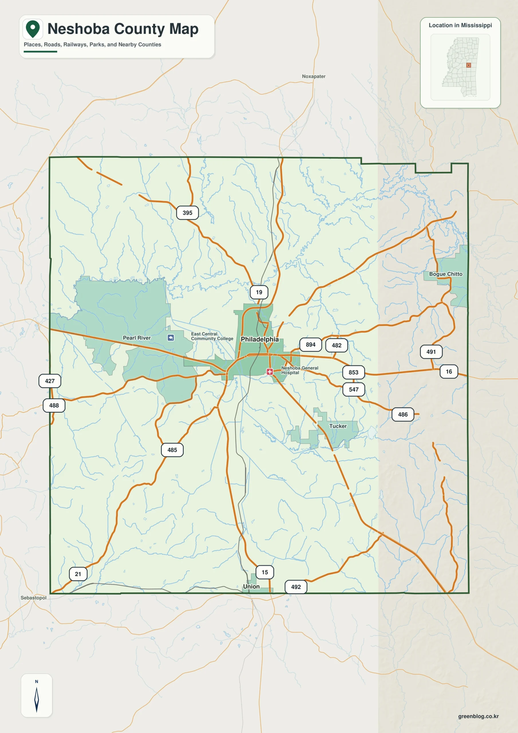
Neshoba County Mississippi map download
The WebP preview is optimized for the page, while the button preserves the original high-resolution JPG for printing and reuse.
- File: County reference map
- Format: JPG
- Print layout: A3
Quick Facts
- State and identifier: Mississippi, Neshoba County; FIPS 28099
- County seat: Philadelphia
- Selected map labels: Philadelphia, Union, Choctaw, Pearl River community
- 2020 census population: 29,087
- July 2025 population estimate: 28,732
- 2025 Gazetteer area: 570.134 sq mi land and 1.479 sq mi water
- 2020 land-area density: 51.0 residents per sq mi
- Primary route references: MS 15, MS 16, MS 19, and MS 21
- Landscape references: Pearl River headwaters, central Mississippi hills, forested creek valleys, and Choctaw homelands
The decennial count and July 2025 estimate use different reference dates. Land and water measurements come from the 2025 Gazetteer. The density of 51.0 residents per square mile divides the 2020 population by 2025 land area and does not imply an even distribution among cities, farms, forest, or wetland.
Reading the Neshoba County Mississippi map
MS 15 leads south from Philadelphia toward Union and Newton County and north toward Winston County. MS 16 connects Leake County on the west with Kemper County on the east. The Choctaw mailing place-name and Pearl River community provide references for tribal areas around Philadelphia; detailed jurisdiction and trust-land boundaries are simplified.
Boundary, Water, and Terrain
Upper Pearl River streams flow south through gently rolling central Mississippi hills. Forest and farmland repeat between Kemper and Lauderdale counties on the east and Leake and Attala counties on the west, with no dominant lake. Highways follow valleys and ridges toward Philadelphia, creating a radial county-road pattern.
Settlement and Regional Context
Philadelphia concentrates courthouse, retail, health care, and local services. Nearby Choctaw communities maintain distinct cultural, governmental, and economic functions, with major Mississippi Band of Choctaw Indians administration at Pearl River. The Neshoba County Fair adds another well-known regional institution, while the 2025 estimate remains slightly below the 2020 count.
Practical Map Uses
- Orient the MS 15 and MS 16 junction at Philadelphia
- Relate Union to the southern Newton County approach
- Explain the relationship among Philadelphia, Choctaw, and Pearl River
Frequently Asked Questions
Does Pearl River name a river or a community here?
Both uses exist. On this page, the selected place label means the Choctaw Pearl River community and should be distinguished from the natural Pearl River drainage.
How does Pearl River headwaters complement Philadelphia when orienting the map toward Winston?
A symbol at Philadelphia fixes one named point; Pearl River headwaters adds a broader frame that can be followed toward Winston without treating every local road as mapped.
Sources
- U.S. Census Bureau QuickFacts
- U.S. Census Bureau 2025 Gazetteer Files
- Mississippi Department of Transportation official highway map
- Regional landscape or institution reference
Related County Maps
Green Map creates custom-edited map images using open geographic data sources such as geoBoundaries, Natural Earth, OpenStreetMap, and government open data.
These maps are edited visual materials, not raw data files, and are provided for education, documents, presentations, and graphic reference.