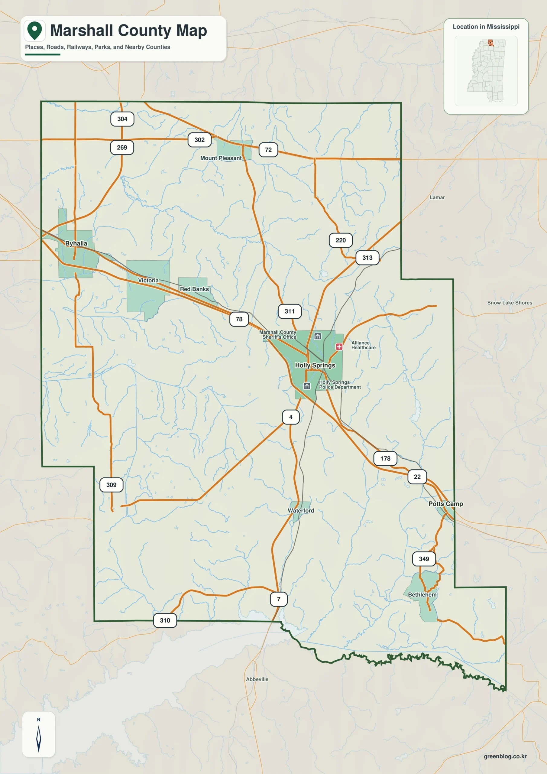
The Marshall County Mississippi map centers on Holly Springs, with Byhalia and Victoria in the northwest and Potts Camp in the southeast. I-22/US 78 links Memphis and Tupelo, while the Tennessee line and scattered Holly Springs National Forest lands divide suburban transition areas from wooded hills.
Marshall County Mississippi map download
The WebP preview is optimized for the page, while the button preserves the original high-resolution JPG for printing and reuse.
- File: County reference map
- Format: JPG
- Print layout: A3
Quick Facts
- State and identifier: Mississippi, Marshall County; FIPS 28093
- County seat: Holly Springs
- Selected map labels: Holly Springs, Byhalia, Potts Camp, Victoria
- 2020 census population: 33,752
- July 2025 population estimate: 34,654
- 2025 Gazetteer area: 706.192 sq mi land and 3.542 sq mi water
- 2020 land-area density: 47.8 residents per sq mi
- Primary route references: I-22/US 78, US 72, MS 7, and MS 302
- Landscape references: Holly Springs National Forest, Wolf River basin, wooded hills, and the Tennessee state line
The decennial count and July 2025 estimate use different reference dates. Land and water measurements come from the 2025 Gazetteer. The density of 47.8 residents per square mile divides the 2020 population by 2025 land area and does not imply an even distribution among cities, farms, forest, or wetland.
Reading the Marshall County Mississippi map
From Holly Springs, I-22 leads northwest toward Byhalia and the Memphis metropolitan area and southeast toward Potts Camp and Union County. Victoria marks the northern area between Byhalia and Holly Springs, while MS 7 provides a route toward Lafayette County. Forest roads and subdivisions are simplified.
Boundary, Water, and Terrain
Fayette and Shelby counties in Tennessee meet the north; DeSoto and Tate counties lie west. Holly Springs National Forest lands occur in multiple tracts across the hillier eastern and southern landscape, while the northwest connects with the Wolf River basin. This creates a strong contrast between developing corridors and forested interior areas.
Settlement and Regional Context
Holly Springs is a historic courthouse, education, and visitor center. Byhalia increasingly reflects access to Memphis-area jobs, logistics, and housing, while Potts Camp is a smaller southeastern highway town. The 2025 estimate is about 2.7 percent above the 2020 count, with growth pressures most visible along the northwestern corridor.
Practical Map Uses
- Follow I-22 among Holly Springs, Byhalia, and Potts Camp
- Relate the Tennessee line to the Memphis approach
- Compare national-forest tracts with the developing northwest
Frequently Asked Questions
Is Byhalia part of the Memphis suburban area?
It lies on a southeastern Memphis approach and is influenced by regional commuting, logistics, and housing. It remains a separate Mississippi city in Marshall County.
How can Holly Springs National Forest clarify the part of Marshall County facing Benton?
Looking only at Holly Springs would reduce the map to town labels, whereas Holly Springs National Forest explains the landscape transition toward Benton.
Sources
- U.S. Census Bureau QuickFacts
- U.S. Census Bureau 2025 Gazetteer Files
- Mississippi Department of Transportation official highway map
- Regional landscape or institution reference
Related County Maps
Green Map creates custom-edited map images using open geographic data sources such as geoBoundaries, Natural Earth, OpenStreetMap, and government open data.
These maps are edited visual materials, not raw data files, and are provided for education, documents, presentations, and graphic reference.