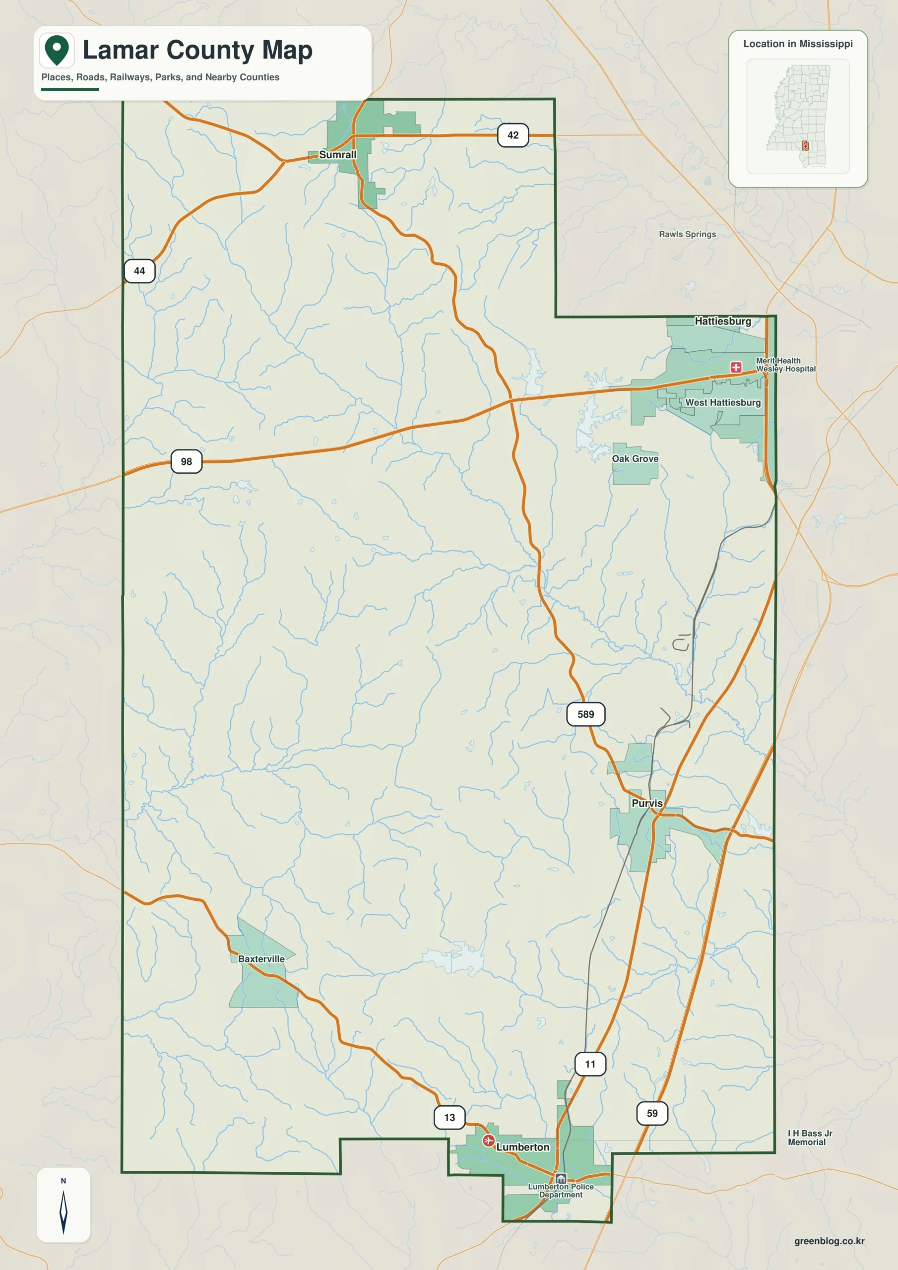
The Lamar County Mississippi map links Purvis in the center, Sumrall in the northwest, Lumberton in the south, and West Hattiesburg on the eastern suburban edge. I-59 and US 98 connect long-established Piney Woods communities with one of the county's fastest-changing residential and commercial areas.
Lamar County Mississippi map download
The WebP preview is optimized for the page, while the button preserves the original high-resolution JPG for printing and reuse.
- File: County reference map
- Format: JPG
- Print layout: A3
Quick Facts
- State and identifier: Mississippi, Lamar County; FIPS 28073
- County seat: Purvis
- Selected map labels: Purvis, Sumrall, Lumberton, West Hattiesburg
- 2020 census population: 64,222
- July 2025 population estimate: 67,403
- 2025 Gazetteer area: 496.570 sq mi land and 3.425 sq mi water
- 2020 land-area density: 129.3 residents per sq mi
- Primary route references: I-59, US 11, US 98, MS 42, and MS 44
- Landscape references: Longleaf pine country, Black Creek tributaries, Leaf River basin, and rolling coastal plain
The decennial count and July 2025 estimate use different reference dates. Land and water measurements come from the 2025 Gazetteer. The density of 129.3 residents per square mile divides the 2020 population by 2025 land area and does not imply an even distribution among cities, farms, forest, or wetland.
Reading the Lamar County Mississippi map
I-59 and US 11 lead south from Purvis toward Lumberton. US 98 crosses West Hattiesburg and continues toward Marion County, while MS 42 connects Sumrall with the Hattiesburg area. Subdivision streets and the full county-road network are too detailed for this selected reference map.
Boundary, Water, and Terrain
The Hattiesburg urban area continues along the Forrest County boundary on the east. Westward, development eases into the wooded landscapes of Marion and Jefferson Davis counties. Small streams and pine-covered rises repeat between Covington County on the north and Pearl River County on the south, so road junctions provide stronger orientation than any single lake.
The figures for Longleaf pine country and Black Creek tributaries add scale to the visible pattern: 496.570 square miles are land and roughly 0.7 percent of the combined area is water. Read Purvis against Sumrall before looking toward Covington; this separates the county’s interior arrangement from its regional edge. Minor lanes on the Covington side are secondary to the broader regional relationship shown here.
Settlement and Regional Context
Purvis is the administrative center, Sumrall anchors a northwestern community zone along the Longleaf Trace, and Lumberton provides a southern highway center. West Hattiesburg concentrates suburban housing, shopping, and services. The 2025 estimate stands about five percent above the 2020 census count, reflecting growth that is unevenly focused near the metropolitan side.
Practical Map Uses
- Follow I-59 between Purvis and Lumberton
- Locate suburban West Hattiesburg along US 98
- Use Sumrall to orient the northwestern Piney Woods
Frequently Asked Questions
Is West Hattiesburg the same as the City of Hattiesburg?
West Hattiesburg is a census-designated area in eastern Lamar County. It is closely tied to the metropolitan area, but the county line remains important for interpreting its location.
What geographic context does Longleaf pine country provide from Purvis toward Covington?
From Purvis, Longleaf pine country supplies a terrain or water cue for tracking the county toward Covington; precise access still belongs to a specialized map.
Sources
- U.S. Census Bureau QuickFacts
- U.S. Census Bureau 2025 Gazetteer Files
- Mississippi Department of Transportation official highway map
- Regional landscape or institution reference
Related County Maps
- Forrest County Mississippi map
- Jefferson Davis County Mississippi map
- Pearl River County Mississippi map
Green Map creates custom-edited map images using open geographic data sources such as geoBoundaries, Natural Earth, OpenStreetMap, and government open data.
These maps are edited visual materials, not raw data files, and are provided for education, documents, presentations, and graphic reference.