The Dominican Republic Map collection on this page presents the country through color, black and white, and blank outline versions. Each image covers the 31 provinces and the Distrito Nacional, while also preserving the country’s shared land border with Haiti. The collection is intended for A3 printing, classroom handouts, presentation slides, geographic comparisons, blog graphics, and projects that require a clean administrative base.
The Dominican Republic occupies the eastern portion of Hispaniola in the Caribbean. Haiti lies directly to the west, the Atlantic Ocean borders the north, and the Caribbean Sea extends along the south. The Mona Passage separates the country’s eastern coast from Puerto Rico. This setting gives the country a distinctive shape: a long northern shoreline, the narrow Samaná Peninsula in the northeast, a broad eastern section, and an irregular international border in the west.
This Dominican Republic Map set is supplied as WEBP image files in an A3 layout. The labeled versions help readers identify provinces such as Santiago, Puerto Plata, La Vega, Samaná, San Juan, and La Altagracia. The blank version leaves room for custom colors, city markers, statistics, travel routes, or classroom notes. Together, the three styles provide a faster way to compare administrative divisions than a simple country outline would offer.
Table of Contents
What Is Included
The collection contains three complementary designs:
- A color map with individually shaded administrative areas
- A black and white map with province names and surrounding geographic labels
- A blank outline map showing national and provincial boundaries
All three versions use the same administrative layout. The color and labeled editions identify the 31 provinces and Distrito Nacional, while Haiti appears in gray to clarify the international border. Atlantic Ocean, Caribbean Sea, and Mona Passage labels provide additional geographic context.
The files do not show highways, tourist attractions, terrain, or local municipal boundaries. Their purpose is to present the country’s major administrative structure in a clean format suited to printing and visual projects.
Reading the Administrative Layout on the Dominican Republic Map
The western border is one of the most important details in the design. Monte Cristi, Dajabón, Elías Piña, Independencia, and Pedernales form the Dominican side of the boundary with Haiti. These are Dominican provinces, not unassigned spaces between the two countries. The jagged line separating the white or colored provinces from the gray Haitian area is the international border.
Moving east, Santiago and La Vega occupy large central areas. Puerto Plata follows the Atlantic coast, while María Trinidad Sánchez and Samaná continue toward the northeastern peninsula. Monte Plata, Hato Mayor, El Seibo, and La Altagracia lead toward the broad eastern end of the country.
The southern coast contains a denser sequence of administrative areas. Distrito Nacional and Santo Domingo sit close together near the capital region, with San Cristóbal to the west and San Pedro de Macorís and La Romana to the east. This difference between broad inland provinces and compact coastal divisions is easier to understand visually than through a list of names alone.
Color-Coded Provincial Map
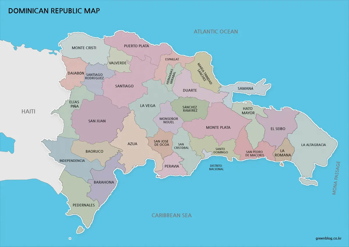
Color gives each neighboring province a separate visual identity. On the Dominican Republic Map, that distinction is particularly helpful around Distrito Nacional, Santo Domingo, San Cristóbal, and San Pedro de Macorís, where several boundaries meet within a relatively small coastal area.
The western half has a different pattern. San Juan, Azua, Baoruco, Barahona, Independencia, and Pedernales form larger blocks, making their size and relationship to Haiti easier to compare. In the northeast, the narrow Samaná Peninsula stands apart from the wider inland provinces.
This edition works well in presentation slides, educational posters, regional comparison charts, and blog graphics. Color also makes it easier to highlight groups of provinces without adding numbered legends or dense annotations.
Labeled Black and White Version
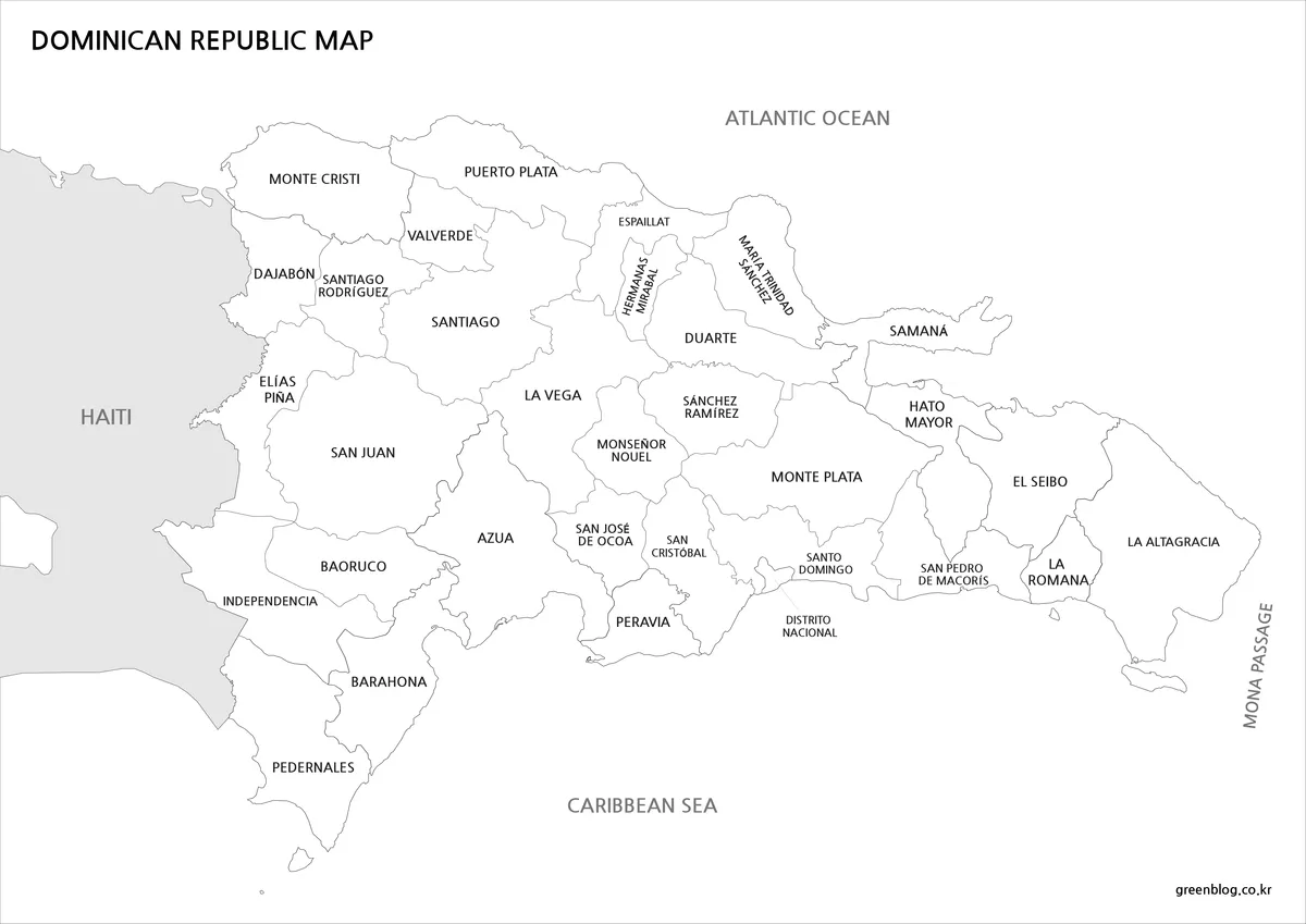
For reports and classroom printing, the Dominican Republic Map in black and white keeps attention on names and boundaries. Reduced color makes labels such as Hermanas Mirabal, María Trinidad Sánchez, Santiago Rodríguez, and Sánchez Ramírez easier to follow in document layouts.
Haiti remains lightly shaded, which preserves the distinction between the two countries without overwhelming the provincial lines. The Atlantic Ocean, Caribbean Sea, and Mona Passage labels help readers orient the island even when the map appears outside a larger Caribbean reference.
This style is suitable for worksheets, school assignments, written reports, and presentation notes. It also reproduces clearly on printers that do not need full-color output.
Blank Outline Map for Custom Projects
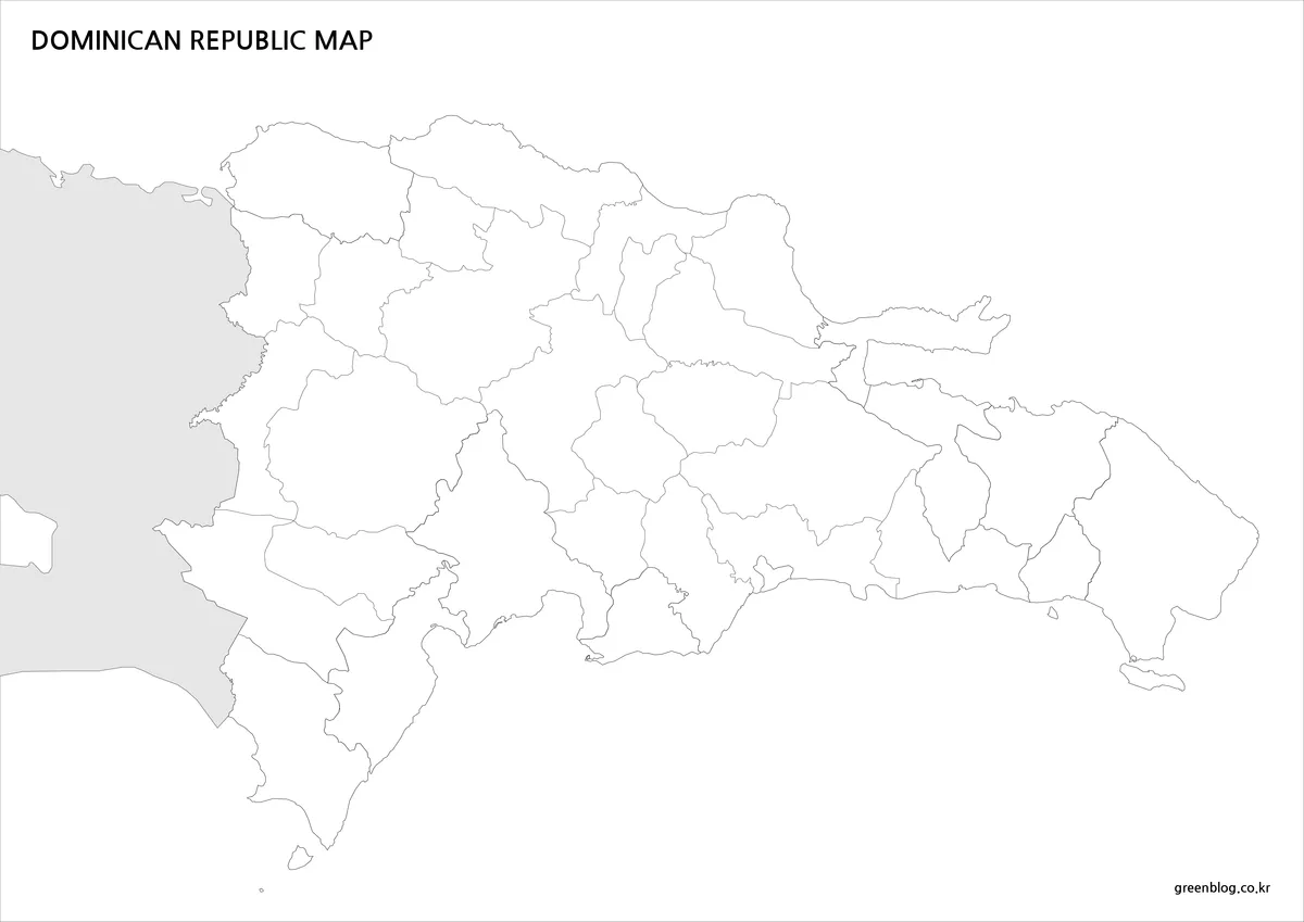
The Dominican Republic Map in outline form removes names and color while retaining the provincial divisions. It serves as a working base rather than simply a reduced copy of the labeled map.
Teachers can turn it into a province-identification exercise or coloring activity. Designers may add population data, regional groupings, transportation routes, city symbols, tourism areas, or presentation highlights. Researchers and bloggers can apply a custom color scale without first removing existing labels.
The western border and the coastline were checked carefully because this is where irregular gaps or overlaps are most noticeable. The outline remains continuous from Monte Cristi in the northwest through Pedernales in the southwest, while the Samaná Peninsula and small coastal islands retain their recognizable shapes.
Province and District Reference
The map covers the following administrative divisions:
| Azua | Baoruco |
| Barahona | Dajabón |
| Duarte | Elías Piña |
| El Seibo | Espaillat |
| Hato Mayor | Hermanas Mirabal |
| Independencia | La Altagracia |
| La Romana | La Vega |
| María Trinidad Sánchez | Monseñor Nouel |
| Monte Cristi | Monte Plata |
| Pedernales | Peravia |
| Puerto Plata | Samaná |
| San Cristóbal | San José de Ocoa |
| San Juan | San Pedro de Macorís |
| Sánchez Ramírez | Santiago |
| Santiago Rodríguez | Santo Domingo |
| Valverde | Distrito Nacional |
Choosing the Right Version
Choose the color edition when viewers need to distinguish neighboring provinces quickly. It is the clearest option for slides, posters, online articles, and visual comparisons.
Use the black and white edition when province names matter more than color. Its restrained design fits reports, handouts, and reference sheets.
Select the outline map when the project requires custom information. It provides enough geographic structure for annotations while leaving the interior visually open.
Frequently Asked Questions
How many administrative divisions are shown?
The map displays 31 provinces and Distrito Nacional. This produces 32 top-level administrative areas in total.
Which Dominican Republic Map is best for classroom printing?
The black and white version works well for labeled reference sheets. The outline edition is better for quizzes, coloring activities, and assignments that require students to add information.
Are the white border areas part of Haiti?
No. Dajabón, Elías Piña, Independencia, and Pedernales are provinces of the Dominican Republic. The gray area west of the international boundary represents Haiti.
Does the collection include roads or tourist attractions?
No. These files focus on provincial boundaries, province names, the national outline, Haiti, and surrounding bodies of water.
Can I add my own data to the outline image?
Yes. The blank layout can be opened in an image editor and used as a base for colors, labels, symbols, routes, and infographic data.
Download Information
Choose the color, black and white, or outline edition according to whether your project needs quick regional comparison, readable province labels, or a blank base for custom information.
Map File Information
This download includes printable Dominican Republic map versions for educational use, presentation design, document printing, and editable graphic projects.
- Included Versions: Color map, black and white map, outline map
- Printable Size: A3 layout
- File Type: WEBP image files
- Intended Use: Classroom handouts, presentations, blog graphics, infographic editing, and printable reference materials
Related Maps
Additional Resources
- Dominican Republic Official Tourism Destinations: Browse official destination information for Santo Domingo, Puerto Plata, Samaná, Pedernales, Santiago, Punta Cana, and other regions shown across the country.
Green Map creates custom-edited map images using open geographic data sources such as geoBoundaries, Natural Earth, OpenStreetMap, and government open data.
These maps are edited visual materials, not raw data files, and are provided for education, documents, presentations, and graphic reference.