You can download three A3 high-resolution JPG maps of Northampton County, North Carolina, as one ZIP file from this page: a county overview, a city distribution map, and a terrain-and-water map. The WebP images in the article are lightweight previews for quick viewing, while the downloadable JPG files are the better choice for printing, presentations, or zooming in on road numbers and smaller place names.
Northampton County lies in northeastern North Carolina and is easier to understand through several local reference points rather than one dominant city. Jackson provides an interior and administrative anchor, Gaston and Garysburg help define the northwest, and Conway, Woodland, and Rich Square organize the eastern and southeastern parts of the county. The maps make that dispersed settlement pattern visible without turning the page into a technical GIS report.
Roads and waterways create the clearest contrasts inside the county. I-95 and US 301 are prominent on the western side near Gaston and Garysburg, while local highways connect Jackson with Seaboard, Conway, Woodland, and Rich Square farther east and south. The water map adds the Roanoke River, Meherrin River, Potecasi Creek, Kirby’s Creek, Ramsey Creek, and other named streams and ponds. Using the three maps together gives a practical picture of where the communities sit and how the county’s road network relates to its rivers and smaller drainage features.
Table of Contents
A long county shape tied together by several road corridors
The county map shows a broad northern section and an irregular outline that narrows toward the south. Gaston lies near the northwestern side, Jackson is farther inside the county, Conway and Woodland sit to the east, and Rich Square occupies a southeastern position. The communities are separated enough that the map does not read like a compact metropolitan area. Instead, the viewer has to follow several road corridors and use different towns as regional anchors. Jackson is useful for finding the county seat, but it does not replace Gaston as a northwest reference or Rich Square as a southeastern reference.
Transportation is especially easy to follow around the western side. I-95 and US 301 appear near the Gaston and Garysburg area, providing an obvious north-south orientation. Routes 46, 48, 158, and 186 are also labeled in the northwestern and upper-central part of the map. Around Jackson, the road network spreads toward both the northwest and the eastern towns. Farther east and south, Route 35 runs near Woodland, while 305, 308, 561, and 258 help organize the Rich Square side of the county. The point is not to memorize every highway number; a few of these labels are enough to keep the major communities in the correct direction.
The surrounding-county labels provide another useful frame. The supplied material identifies Halifax and Warren on the western side and Hertford and Bertie on the eastern side as important neighbors. Roads continue across the county line, so an adjacent-county comparison is easier when a Northampton community is chosen first. Gaston is a convenient reference for looking west toward Halifax, while Conway or Woodland helps organize the eastern side toward Hertford. This is particularly useful when several county maps are being compared and the viewer wants to avoid treating each outline as an isolated shape.
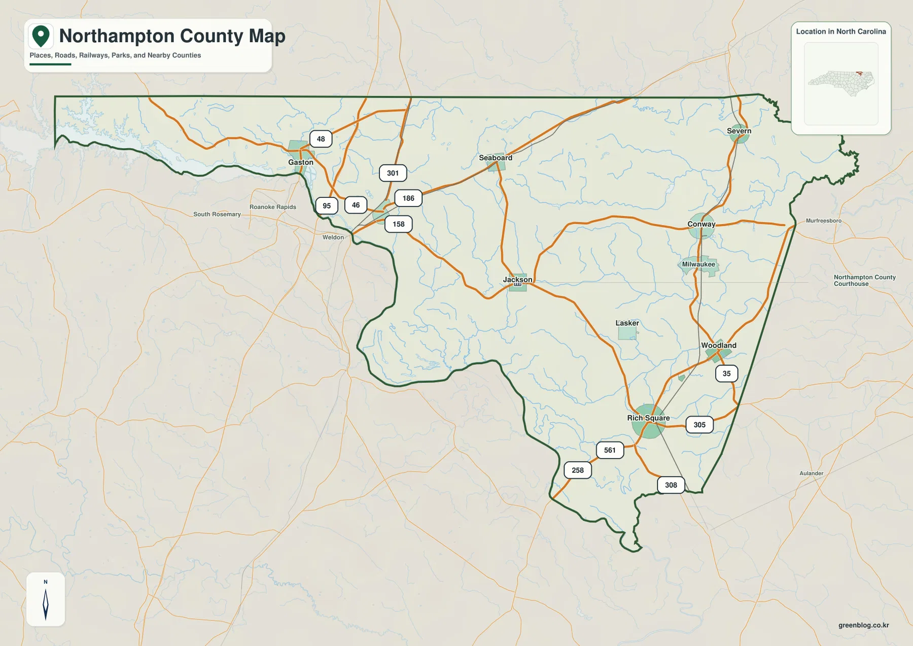
This overview works best as a location and orientation map rather than as a street-level navigation product. The labeled roads show how the main communities relate to one another, while the streams in the background add physical context without overwhelming the road information. The northwest has a visibly broader water edge, and the interior and east contain many smaller drainage lines. When the boundary, roads, settlements, and water are viewed together, Northampton appears as a dispersed rural county whose communities are connected by several routes rather than by one central street grid.
Gaston, Jackson, Conway, and Rich Square form separate local reference points
The city map removes much of the background detail and emphasizes six named places: Gaston, Rich Square, Conway, Jackson, Seaboard, and Garysburg. Its city index ranks the same six places, but the more useful information for map reading is their spread across the county. Gaston and Garysburg cluster toward the west and northwest. Seaboard sits farther north and east, Jackson occupies the interior, Conway marks the eastern side, and Rich Square is well to the southeast. The spacing makes clear why a single-center description is not enough for Northampton County.
Jackson matters because it is the county seat, yet the city map shows why administrative importance and geographic centrality are not the same thing. A person interested in the Lake Gaston and Roanoke side will naturally use Gaston or Garysburg as a better reference. Someone focusing on the eastern part of the county may begin with Conway, while Rich Square is the clearest label for the southeastern rural area. Seaboard fills an important gap in the northern interior. Together, these places create a practical set of anchors that can be carried back to the more detailed county map.
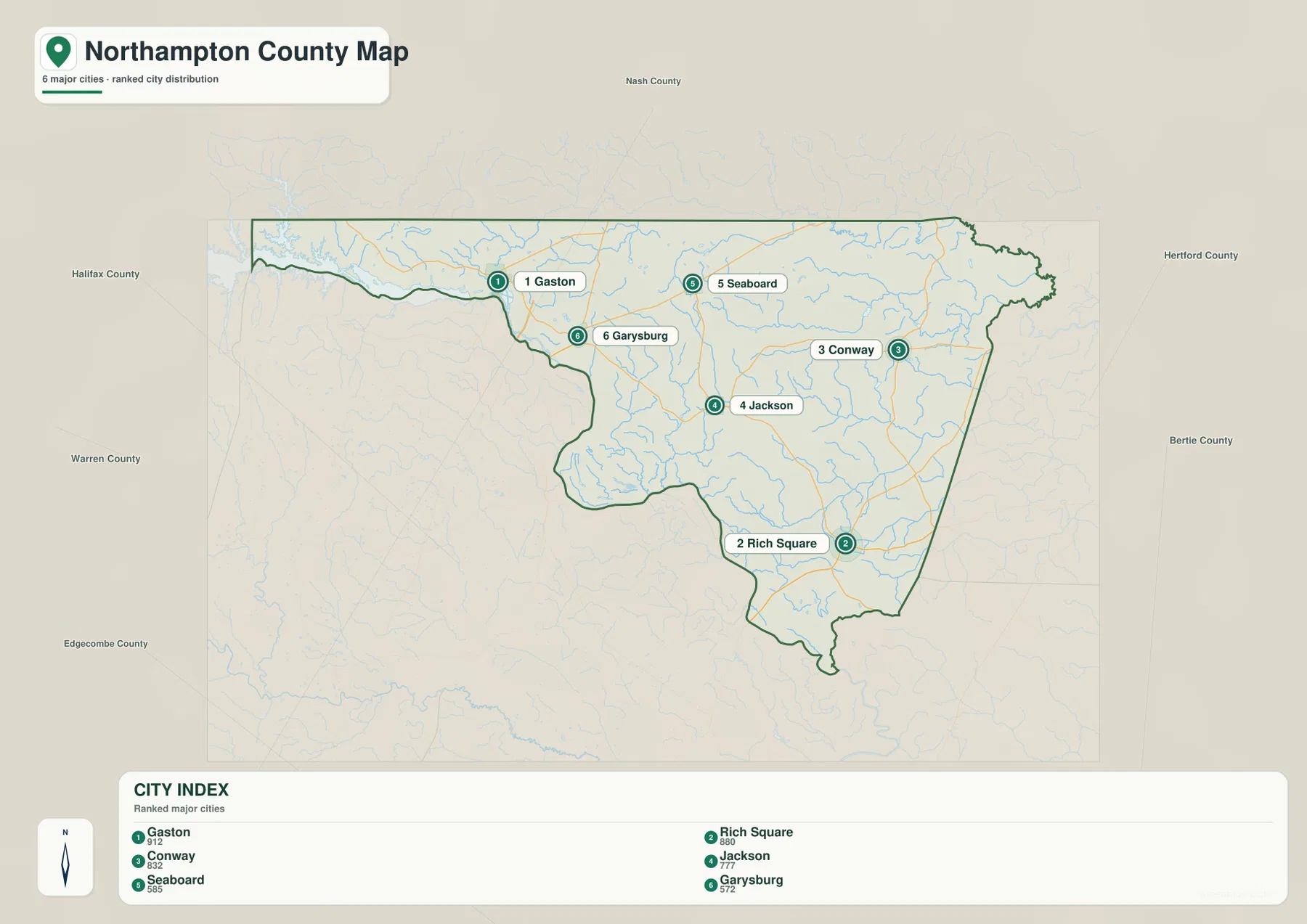
A city-distribution map is useful for relative position, but it should not be mistaken for a driving-distance map. Straight-line separation between map points does not account for road bends, crossings, or the route a vehicle must actually follow. For planning a trip, use the city map to understand direction first and then check current navigation information. For a school project, county profile, presentation, or regional comparison, however, the simplified city view is often enough to answer basic questions such as which places are in the northwest, which community is central, and how far the southeastern settlement pattern extends.
The western pair of Gaston and Garysburg also connects naturally with the transportation pattern on the overview map. After locating those two places, I-95 and US 301 become much easier to recognize. Moving eastward, Jackson gives the viewer a mid-county reset before the map spreads toward Conway and Woodland. Rich Square then establishes the lower southeastern portion. This sequence is a simple way to keep orientation in a county where many named roads and small streams can otherwise make the full map look busy.
From the Roanoke River to Potecasi Creek, water divides the county into distinct areas
The water map provides the most detailed natural-geography view in the package. The Roanoke River is labeled along the southwestern side, while the broad water in the northwest continues the Lake Gaston–Roanoke setting visible on the general map. The Meherrin River appears near the northeastern edge. Between those large references, a network of smaller waterways crosses the county: Kirby’s Creek in the northeast, Potecasi Creek farther south on the eastern side, Ramsey Creek in the interior, Gumberry Swamp in the west-central area, and Occoneechee Creek toward the southwest.
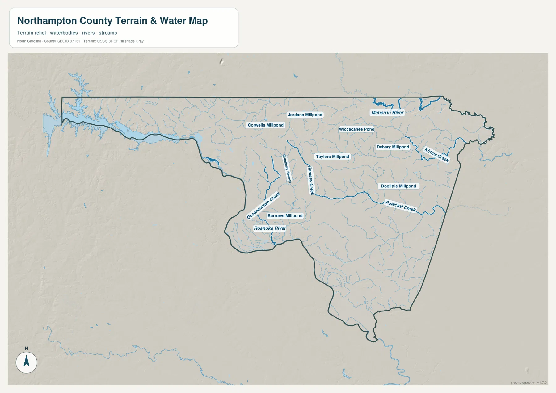
Named ponds and millponds add another layer of local detail. Corwells Millpond and Jordans Millpond appear in the upper part of the county, Wiccacanee Pond is farther east of center, and Debary Millpond sits in the northeastern interior. Taylors Millpond, Doolittle Millpond, and Barrows Millpond are also labeled in different sections. These are not just decorative labels. They help a reader distinguish parts of the county that might otherwise look similar on a road-only map, especially where the terrain is broad and the communities are small.
The shaded background helps separate stream valleys and broad land surfaces, but it should not be read as a survey-grade elevation product. The relief shown here is subtle rather than mountainous, which fits the source description of a county dominated by Coastal Plain conditions with some transition toward the Piedmont edge. The purpose is visual orientation: streams become easier to follow when they are placed over a terrain backdrop. Anyone needing precise elevation, engineering measurements, flood-zone boundaries, parcel lines, or legal navigation information should use the appropriate official dataset rather than treating this reference map as a substitute.
Water also improves the way the towns are understood. Gaston is naturally associated with the northwest water side, while Jackson sits among a more complex interior network of smaller channels. Conway and Woodland lie closer to the eastern creek system, and the Rich Square area is surrounded by another dense set of smaller drainage lines. Roads alone can make these communities look like points on an open rural surface. Adding the water map gives each part of the county a more specific physical setting and helps explain why the northwest and east feel different even within the same county.
Which Northampton County map should you use first?
Use the general county map first when the question involves roads, community locations, the county boundary, or nearby counties. It gives the broadest combination of information and is the easiest way to move from Gaston in the northwest through Jackson to Conway, Woodland, and Rich Square. If the main goal is to compare the relative positions of settlements without the distraction of many road and stream labels, switch to the city map. Its six highlighted places make the dispersed pattern immediately clear and are especially useful in presentations or short county profiles.
Choose the water map when rivers, creeks, ponds, and the terrain background matter more than road numbers. The Roanoke and Meherrin rivers provide large boundary references, while Potecasi Creek, Kirby’s Creek, Ramsey Creek, Gumberry Swamp, Occoneechee Creek, and the named millponds add local detail. This makes the water map useful for environmental context, school geography, or a regional article that needs to describe where water features occur. It is not intended to show flood risk, property ownership, legal boundaries at parcel scale, or safe boating routes.
For printing or editing, the downloadable JPG files are preferable to the web previews because the package contains the matching A3 high-resolution versions of all three supplied maps. The archive name includes both Northampton County and North Carolina, which helps distinguish this county from other U.S. counties with the same official name. A single map can be used on its own, or the overview and water maps can be paired when a document needs both transportation context and physical geography. The city map works well beside either one when the audience needs a simplified settlement reference.
Frequently Asked Questions
Should I start with Jackson or Gaston when orienting the county?
Jackson is the easiest first reference when you want the county seat and an interior location. From there, Gaston and Garysburg help define the northwest and the I-95–US 301 side, while Conway, Woodland, and Rich Square organize the east and southeast. Gaston is especially useful when the Lake Gaston and Roanoke River setting matters to the map question.
Which waterways are useful beyond the Roanoke River?
The Meherrin River is the strongest large-water reference on the opposite side of the county. Potecasi Creek and Kirby’s Creek help explain the east, while Ramsey Creek, Gumberry Swamp, and Occoneechee Creek add interior and western detail. The named millponds and Wiccacanee Pond are useful smaller landmarks when a project needs more than the two major rivers.
What is included in the Northampton County download?
The archive contains the same three map types used in the article: a county overview, a city distribution map, and a terrain-and-water map. Each is supplied as an A3 high-resolution JPG. The WebP images on the page are lighter previews, so the JPG files are the better choice when small labels, road numbers, or water names need to remain clear.
Map File Information
The ZIP contains three A3 high-resolution JPG files matching the Northampton County overview, city distribution, and terrain-and-water maps shown on this page. Use the download when you need larger labels, clearer road numbers, or files suitable for printing and document layouts.
- Included Files: county map, city map, terrain-and-water map
Related Maps
Sources and references
The following county reference and federal mapping resources support the geographic context, boundary information, and water features used for this map page.
Green Map creates custom-edited map images using open geographic data sources such as geoBoundaries, Natural Earth, OpenStreetMap, and government open data. These maps are edited visual materials, not raw data files, and are provided for education, documents, presentations, and graphic reference.