Harnett County is easier to understand when you look beyond the county seat. Lillington sits near the middle, Angier is well to the north, Dunn and Erwin cluster in the southeast, and Anderson Creek and Spout Springs occupy a very different corner in the southwest. The Cape Fear River crosses the county between these settlement areas, while major roads connect them in several directions rather than through one single urban center. This page explains those relationships from the maps themselves, and you can download the three A3 high-resolution JPG map files in one ZIP after reviewing the previews.
The county government describes Harnett as a place between the Piedmont, Sandhills, and Coastal Plain. That transition is useful context for the map: the western and southwestern side contains broad rural areas and scattered communities, while the eastern side has a clearer chain of towns and the Interstate 95 corridor near Dunn. Instead of forcing the county into a simple north-south or east-west pattern, it is better to use Lillington, the eastern municipalities, and the Cape Fear River as separate reference points.
Table of Contents
Start with Lillington, then follow the roads outward
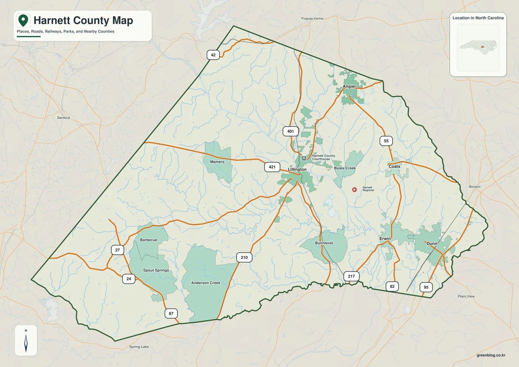
Lillington is the county seat and appears near the center of the general county map. U.S. 401 runs through the area on a north-south line, while U.S. 421 approaches from the west and continues eastward. North Carolina 210 also leaves the Lillington area toward the south and southwest. These routes make the town a practical starting point for orientation because several parts of Harnett can be reached visually from the same place on the map.
From Lillington, the county quickly splits into different directions. Buies Creek lies just to the east. Angier is farther north, close to the upper county boundary, and is connected back toward central Harnett by the U.S. 401 corridor. Coats sits east of Lillington, while Erwin and Dunn are farther southeast. The map therefore does not show one continuous built-up center. It shows several communities separated by rural land, streams, and road corridors, which is why a county-wide view is more useful here than simply locating the county seat.
Dunn, Erwin, Coats, and Angier form separate town clusters
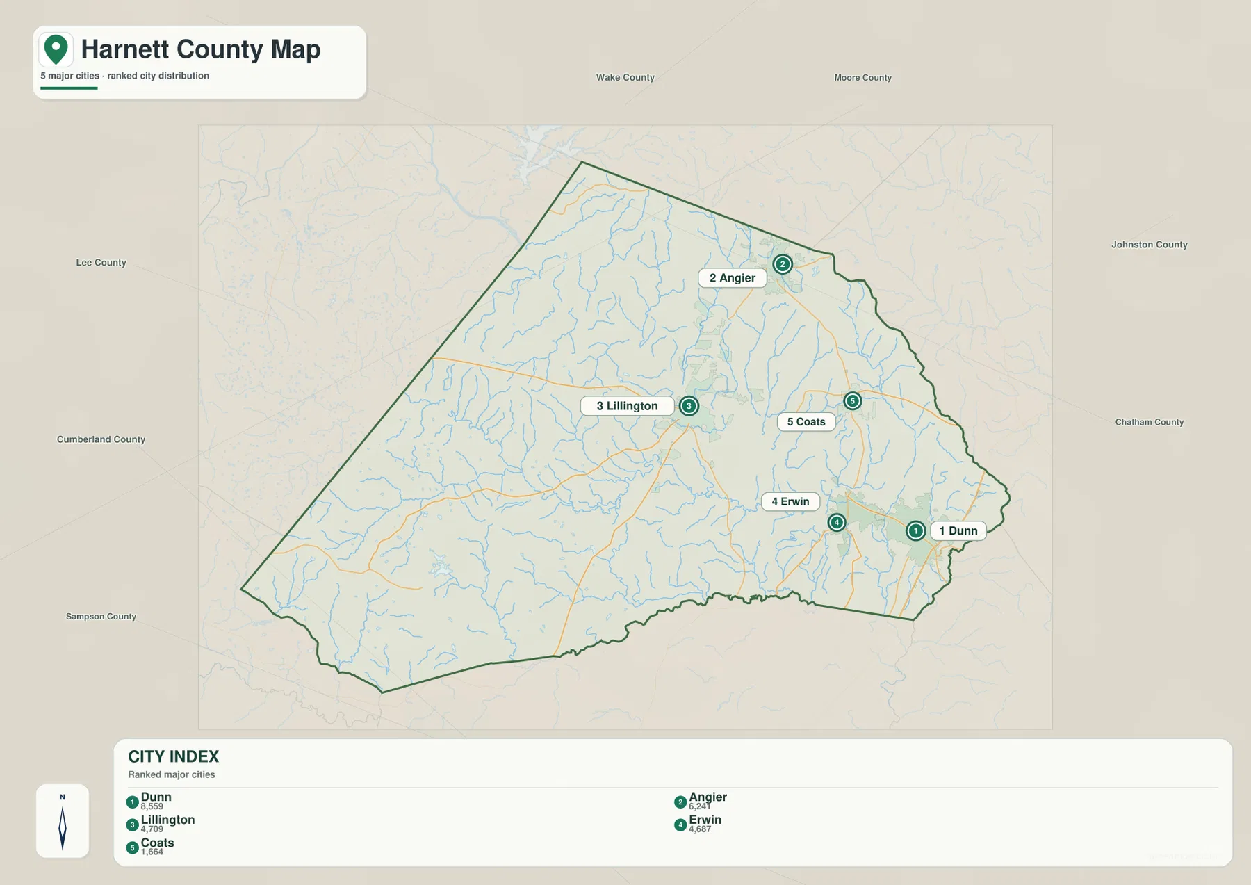
The city-distribution map highlights five municipalities rather than every community label. Dunn is marked first in the map index, followed by Angier, Lillington, Erwin, and Coats. The numbering is less important than the geometry. Dunn and Erwin sit close together in the southeast, Coats is farther north, Angier stands by itself in the northern part of the county, and Lillington occupies a more central position. That arrangement explains why a visitor who only looks for the “main town” can miss how spread out Harnett really is.
Dunn also has a road pattern that is different from Lillington’s. Interstate 95 runs along the eastern side near Dunn, giving this part of the county a strong north-south highway reference. North Carolina 55 links the Angier and Coats side with the eastern towns, while other state routes connect Erwin and the smaller communities south of Lillington. For someone planning a regional trip, comparing the city map with the general road map makes it much easier to distinguish the I-95 side of Harnett from the U.S. 401 and U.S. 421 routes around the county seat.
The surrounding counties are another useful guide. Harnett borders Wake, Johnston, Sampson, Cumberland, Moore, Lee, and Chatham Counties. On the city map, the county names around the outside provide immediate directional context: Angier is on the Wake side, Dunn is toward the Johnston and Sampson side, and the broad southwestern part of Harnett faces Cumberland and Moore. This border context is especially helpful when a place name sits near the edge and could otherwise look disconnected from the rest of the county.
The southwest is better read by communities and route numbers
The western and southwestern half of Harnett looks much less like the Dunn-Erwin side. Mamers appears west of Lillington along U.S. 421, while Barbecue, Spout Springs, and Anderson Creek are spread across the lower-left portion of the map. North Carolina 87, 24, 27, and 210 provide useful road references in this area. Rather than using a single city as the anchor, it is more practical to match a community name with the nearest route and then compare that position with the county boundary.
Bunnlevel provides another useful checkpoint south of central Harnett. It lies between the Lillington side and the Erwin-Dunn side, but it is surrounded by smaller roads and waterways rather than by the dense highway pattern visible near I-95. This is a good example of why the same county map can serve different purposes: a reader interested in broad travel routes may focus only on the major highways, while someone locating a rural address will need the smaller community labels and local road network.
Cape Fear River is the central water reference
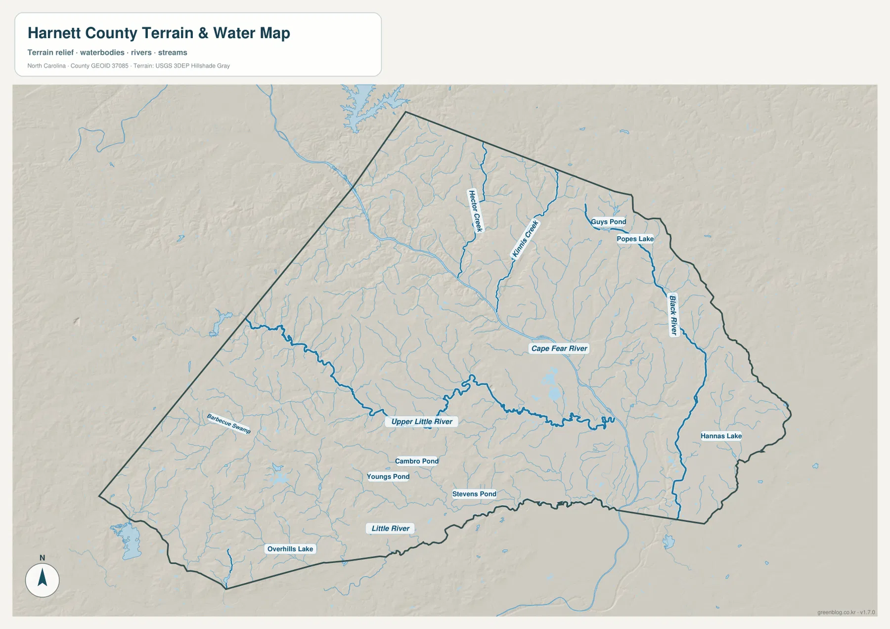
The terrain-and-water map changes the way Harnett looks. Roads and municipal labels are no longer the main feature; the Cape Fear River becomes the clearest line across the middle of the county. County government material identifies it as Harnett’s principal drainage system, and the map shows why it is such a useful reference. Lillington sits near this river corridor, so a reader can use the Cape Fear to connect the administrative center with the county’s physical geography rather than treating the town and river as unrelated labels.
The Upper Little River is another prominent feature. It winds from the western side toward the central part of Harnett and approaches the Cape Fear system. On the eastern side, the Black River runs on a more north-south course. Hector Creek is visible in the northern interior, while Little River follows part of the southern side. Together these waterways divide the county into many smaller drainage areas, a pattern that is easy to miss on the road-focused map.
Smaller water bodies add local detail. Overhills Lake appears in the southwest, Hannas Lake is in the eastern part of the county, and the map also labels Cambro Pond, Youngs Pond, Stevens Pond, Guys Pond, and Popes Lake. These names are useful for local orientation, but they should not be confused with flood-hazard or property-boundary information. The terrain shading is designed to help show broad relief and stream valleys; it does not replace an official floodplain, parcel, or engineering map.
Choose the map by the question you need to answer
Use the general county map when you need the broadest combination of information. It places the boundary, towns, major roads, rail lines, parks, and nearby counties in one view. This is the best starting point for understanding where Lillington sits relative to Angier or Dunn, where I-95 touches the county, or which direction to follow before moving to a more detailed street or navigation map.
The city-distribution map is better when the main question is settlement. Because it emphasizes the five municipalities, it removes much of the extra map detail and makes the relative positions of Dunn, Angier, Lillington, Erwin, and Coats easy to compare. It is useful for presentations, school projects, and quick regional orientation where the location of the towns matters more than every road or creek.
Choose the terrain-and-water map when rivers, tributaries, ponds, and broad relief matter more than municipal boundaries. The Cape Fear River, Upper Little River, Black River, and the smaller streams become the structure of the map. This version is especially helpful for learning the county’s physical geography or for identifying which named waterway is near a community before consulting a specialized environmental map.
The web images above are optimized for viewing in the article. If you need a larger file for printing, classroom use, a local reference sheet, or your own project, the download package contains all three maps as A3 high-resolution JPG files. The ZIP keeps the files together so you can choose the general, city, or water-and-terrain version without downloading them separately.
Frequently Asked Questions
Where should I look first to find Lillington on the Harnett County map?
Start near the middle of the county where U.S. 401 and U.S. 421 meet. Lillington is also close to the Cape Fear River, so using both the road junction and the river makes the county seat easy to distinguish from Dunn to the east or Angier to the north.
Why do Dunn and Erwin appear so close together?
Both communities are in southeastern Harnett County and are neighboring points on the map. Dunn lies close to the I-95 corridor, while Erwin is just to its west. Looking at them together is the quickest way to understand the more urbanized eastern side of the county.
What waterways are shown besides the Cape Fear River?
The water map labels the Upper Little River, Little River, Black River, Hector Creek, and several smaller streams. It also marks local lakes and ponds such as Overhills Lake and Hannas Lake, which makes the map useful for comparing large river corridors with smaller water features.
Sources and Reference Data
- Harnett County Government – Municipalities
- NCpedia – Harnett County
- U.S. Census Bureau – TIGER/Line Shapefiles
- USGS – National Hydrography
- USGS – 3D Elevation Program
Map File Information
The ZIP contains three A3 high-resolution JPG files for Harnett County.
- Included Files: General county map, city map, and water-and-terrain map
- File Type: Three high-resolution A3 JPG files in one ZIP archive
- Intended Use: Printing, education, presentations, and map-based projects
Related Maps
Green Map creates custom-edited map images using open geographic data sources such as geoBoundaries, Natural Earth, OpenStreetMap, and government open data. These maps are edited visual materials, not raw data files, and are provided for education, documents, presentations, and graphic reference.