Granville County sits in north-central North Carolina, stretching from the Virginia line to a southern group of communities that includes Stem, Creedmoor, and Butner. Oxford, the county seat, is slightly east of the county’s center and serves as the easiest place to orient yourself on the main road-and-boundary map. I-85 passes through the central and southern part of the county, while US 158 crosses the Oxford area. The three map views on this page separate that information into a general county map, a city-distribution map, and a terrain-and-water map. The WebP images are sized for quick viewing online, and the matching A3 high-resolution JPG files are available together in the ZIP download farther down the page.
Granville County is easier to understand when Oxford is not treated as the only reference point. Stovall is well to the north, while Stem, Creedmoor, and Butner form a more southern group. The county government identifies those five places—Oxford, Butner, Creedmoor, Stovall, and Stem—as the municipalities within Granville County. NCpedia places the county in the Piedmont region of north-central North Carolina and notes that Virginia forms part of its northern boundary. Within North Carolina, Granville adjoins Person, Durham, Wake, Franklin, and Vance counties. Keeping those surrounding counties in mind makes the road network, city pattern, and stream directions much easier to follow.
Table of Contents
Oxford at the center of roads, boundaries, and nearby counties
The main county map is the best starting point when you need roads and place names together. Oxford is labeled near the middle-east side of the county, with I-85 running through the area on its way between the southern part of Granville and the northeast. US 158 crosses the Oxford area from west to east. Farther south, the map labels US 15 and state routes 50, 56, and 96 around the Butner-Creedmoor side of the county, while NC 49 appears toward the northwest. These route labels are useful for geographic orientation: they show which communities sit near the same roads and which directions lead toward adjoining counties. The map is not a turn-by-turn navigation product, so it is better used to understand county-scale relationships than to plan a precise drive.
The county outline also makes Granville’s long north-south shape clear. Person and Durham counties lie along the west and southwest side, Wake County is close to the southern edge, and Franklin and Vance are on the east side. Virginia meets the county at the north. Once Oxford is located, Stovall can be found to the north, Stem to the southwest, and Creedmoor and Butner farther south. This spacing matters because the county does not function visually as one compact cluster. The northern edge, Oxford’s central administrative role, and the southern communities each occupy distinct parts of the map.
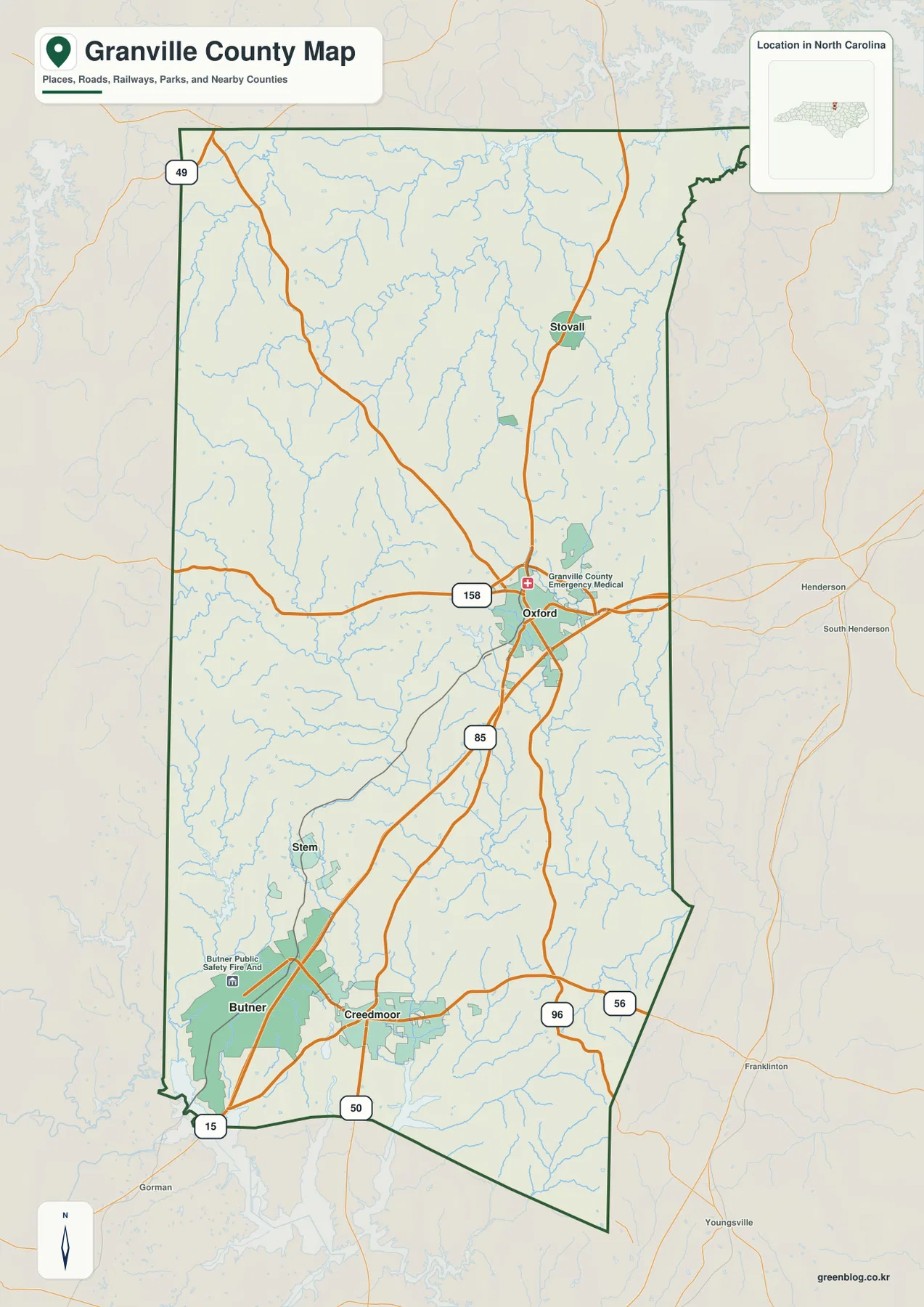
This view works especially well for reports, classroom material, and local-reference pages that need more than a simple outline. It keeps the county boundary, the principal community labels, roads, selected facilities, parks, and streams on the same page. If your goal is to explain where Oxford sits in relation to the southern towns or which side of Granville is closest to Durham, Wake, Franklin, Vance, or Person County, the general map provides the broadest context. For a cleaner comparison of the five municipalities, the next map removes much of that detail and makes the settlement pattern the main subject.
From Stovall to Butner: the five-municipality pattern
The city-distribution map isolates Oxford, Butner, Creedmoor, Stem, and Stovall so their relative positions are easy to compare. Oxford stands out in the middle-eastern part of the county. Stovall is separated from it to the north, close to the upper third of the county, while Stem sits southwest of Oxford. Creedmoor and Butner occupy the southern portion and are much closer to one another than either is to Stovall. That simple arrangement explains a great deal about how the county reads on a map: settlement is not spread evenly from north to south, and the southern communities form a noticeably tighter group.
Granville County’s official profile confirms that these are the county’s five municipalities. The map is most useful when you treat the labels as location markers rather than as a permanent population ranking. Population totals can change from one estimate or census period to another, but the geographic relationship among the municipalities is far more stable. From Oxford, moving south brings Stem, Creedmoor, and Butner into view; moving north leads toward Stovall and eventually the Virginia boundary. That makes the city map a straightforward companion to demographic tables, school materials, or local planning documents where the names need to be placed accurately before additional statistics are added.
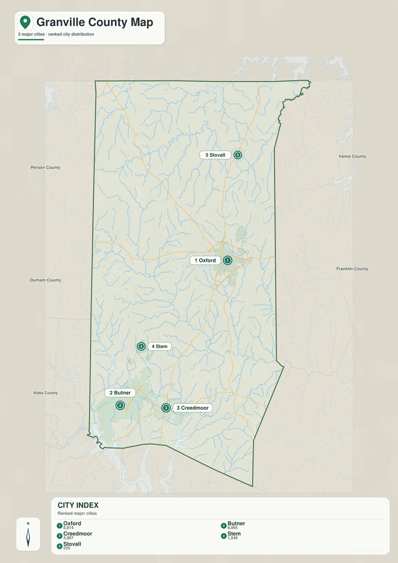
The strongest contrast is between the isolated northern position of Stovall and the clustered southern locations of Butner and Creedmoor. Oxford falls between those two extremes and remains the county seat, so it is a practical middle reference. Stem helps bridge the Oxford-to-south relationship on the west side. This view is intentionally simpler than the general map: it does not try to replace road or water detail, but it makes it much easier to explain where the county’s named municipalities sit before introducing those other layers.
Tar River headwaters, creeks, and the rolling Piedmont surface
The terrain-and-water map shifts attention away from towns and roads. The Tar River is the most prominent named watercourse across the central-to-southern part of the county. Grassy Creek is labeled in the northwestern interior, with Shelton Creek farther west and Aaron’s Creek near the upper western side. Johnson Creek appears in the north-central area, while Island Creek and Coon Creek are labeled on the east side. Knapp of Reeds Creek is shown in the southwest. Smaller named water bodies include Briggs Lake, Lake Devin, Veazys Lake, and Lake Rogers, and John H. Kerr Reservoir appears beyond or along the northeastern edge of the map context.
The shaded terrain behind the streams shows a gently rolling Piedmont landscape rather than mountain relief. Valleys are subtle, but the branching drainage lines make the low areas visible because streams collect in them. NCpedia notes that Granville County includes land in the Neuse, Roanoke, and Tar-Pamlico river basins. Those basin names are useful background for understanding why water does not all leave the county in a single direction, although this map does not draw formal watershed boundaries. It is a visual reference for rivers, creeks, lakes, and terrain, not a flood-zone, parcel, navigation, or engineering map.
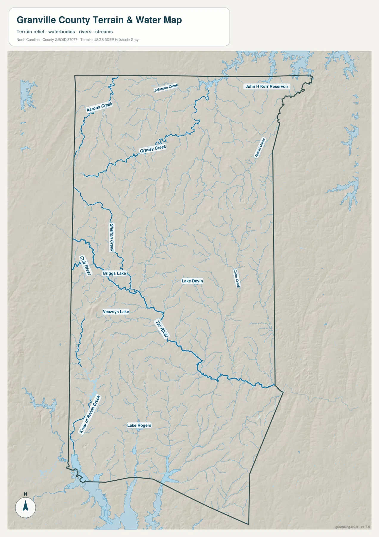
Use this map when the subject is physical geography rather than settlement. It is well suited to explaining where the Tar River crosses the county, how smaller creeks branch through the north and west, or where named lakes sit relative to the county boundary. It should not be used to estimate water depth, current stream level, flood risk, or property limits. For those purposes, current agency data and site-specific mapping are necessary. Here, the value is county-scale orientation: the map makes a dense stream network understandable without adding the visual weight of every road and urban label.
Why southern Granville is often discussed with the Falls Lake area
Falls Lake is often part of the conversation about southern Granville even when a county-wide map is centered on Oxford and the Tar River. The connection is broader than the reservoir shoreline. Granville County’s North Falls Lake Area Study covers southern and central Granville and specifically includes Butner, Creedmoor, Oxford, and Stem, along with northern Wake County and western Franklin County. The county says the study was completed in June 2026 and was designed to consider where future homes and businesses are likely to develop and what transportation system may be needed to support that growth.
The map helps explain why that study area crosses county lines. Butner and Creedmoor sit close to Granville’s southern edge, and I-85 plus several state routes connect this part of the county toward Durham, Wake, and Franklin counties. Oxford remains farther north as the county seat, so southern growth connections and the county’s administrative center are not located in the same place. Treating Falls Lake only as a single lake label can hide that wider relationship. For Granville County, the more useful context is the southern watershed and regional planning area that ties several municipalities and neighboring counties together.
Choosing the right Granville map for a document or print project
Choose the general county map when you need boundaries, roads, and communities on the same page. Choose the city-distribution map when the five municipalities are the main subject and extra road or stream labels would distract from the comparison. Choose the terrain-and-water map for the Tar River, creeks, lakes, and relief. The three views cover the same county but emphasize different questions, so using the map that matches the subject usually produces a clearer page than trying to make one image do everything. The on-page WebP versions are optimized for viewing in a browser; the downloadable files provide the matching A3 high-resolution JPGs for larger output.
For print work, keep the original image proportions when resizing. The general map is the most versatile choice, while the city and water views are better when a narrower topic needs to stand out. Because the JPG files correspond to the previews in the article, you can decide which map fits your project before downloading rather than discovering a different set of layers afterward.
Frequently Asked Questions
How can I quickly compare Oxford with Butner and Creedmoor?
Start with Oxford near the middle-east portion of the county and follow the I-85 corridor south. Stem lies southwest of Oxford, while Creedmoor and Butner are farther south and relatively close to each other. That sequence makes the north-south settlement pattern much easier to see than reading the town names separately.
What should I look for first on the terrain-and-water map?
Find the Tar River first, then trace the named tributaries such as Grassy Creek, Shelton Creek, Johnson Creek, Island Creek, and Knapp of Reeds Creek. Smaller lakes provide additional landmarks. The map is designed for geographic orientation, so it does not show navigation depth, real-time water levels, flood zones, or legal property boundaries.
Does the ZIP contain the same maps shown on this page?
Yes. The ZIP contains three A3 high-resolution JPG files corresponding to the county map, city-distribution map, and terrain-and-water map described above. The WebP images in the article are convenient previews, while the JPG versions are better suited to printing or larger document layouts.
Map File Information
This ZIP contains the A3 high-resolution JPG versions of the Granville County general map, city-distribution map, and terrain-and-water map shown in this article.
- Included Files: 3 high-resolution A3 JPG maps described on this page
- File Type: JPG files in a ZIP archive
- Intended Use: Printing, education, presentations, and map-based projects
Related Maps
Sources and References
The following public and official sources were used to check county background and the geographic features represented by the maps.
- Granville County Government – About Us – county boundaries, area, and the five municipalities
- Granville County – North Falls Lake Area Study (2026) – southern and central Granville growth and transportation context
- NCpedia – Granville County – county history, Oxford, Piedmont location, and river-basin background
- U.S. Census Bureau – TIGER/Line Shapefiles – administrative boundary, road, and place-reference data
- USGS – National Hydrography – streams, rivers, and water-body reference data
- USGS – 3D Elevation Program – elevation data used for terrain context and hillshade reference
Green Map creates custom-edited map images using open geographic data sources such as geoBoundaries, Natural Earth, OpenStreetMap, and government open data. These maps are edited visual materials, not raw data files, and are provided for education, documents, presentations, and graphic reference.