Dare County is easier to understand as a set of connected coastal pieces than as one compact block of land. The map stretches from Duck, Southern Shores, Kitty Hawk, Kill Devil Hills, and Nags Head in the north to Avon, Buxton, Frisco, and Hatteras much farther south. Between those long barrier-island sections, Manteo and Wanchese sit on Roanoke Island, while Manns Harbor lies on the mainland side. That broken shape is the most important fact to keep in mind before comparing roads, towns, or water.
This page provides a Dare County Map set for readers who want both a quick geographic explanation and downloadable files. The county map emphasizes boundaries, roads, and named places; the city map makes the northern beach communities and Manteo easier to compare; and the water map brings Albemarle Sound, Pamlico Sound, Currituck Sound, bays, creeks, and other coastal water into the foreground. The download box below contains the same three subjects as high-resolution A3 JPG files in one ZIP archive.
The key is to resist treating Manteo as if it were the physical center of every part of the county. It is the county seat and an essential reference point, but the northern beach towns form their own close chain, the mainland west of Roanoke Island has a different pattern of roads and waterways, and the Hatteras section continues far beyond Nags Head along a narrow strip. Reading those parts separately first makes the full county much easier to follow.
Table of Contents
A county stretched across barrier islands, Roanoke Island, and mainland
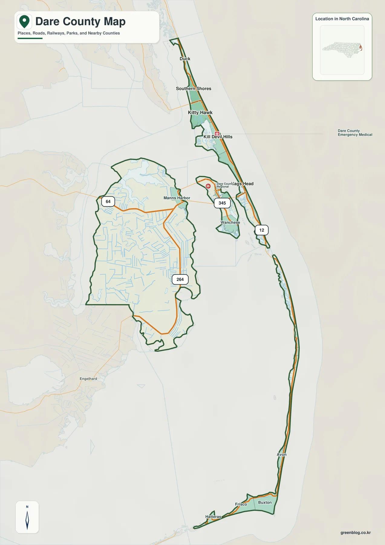
The county map immediately shows an unusual outline. The northern Outer Banks portion is narrow and elongated, with Duck near the top and a succession of communities continuing south through Southern Shores, Kitty Hawk, Kill Devil Hills, and Nags Head. Farther down, the coastline narrows again into the Hatteras section, where NC 12 passes Avon, Buxton, Frisco, and Hatteras. These places are part of the same county, but they are separated by enough distance and water that a simple center-to-edge description does not work well.
The mainland portion west of Roanoke Island looks very different. Manns Harbor is the most prominent named community there, and the map shows a broad interior crossed by many small waterways. Roanoke Island forms another distinct piece between the mainland and the oceanfront strip, with Manteo toward the northern part of the island and Wanchese farther south. Seeing those four components—northern beaches, Roanoke Island, mainland, and the long southern barrier island—explains why road connections and water crossings matter so much in Dare County.
The northern beach towns form the county’s tightest settlement chain
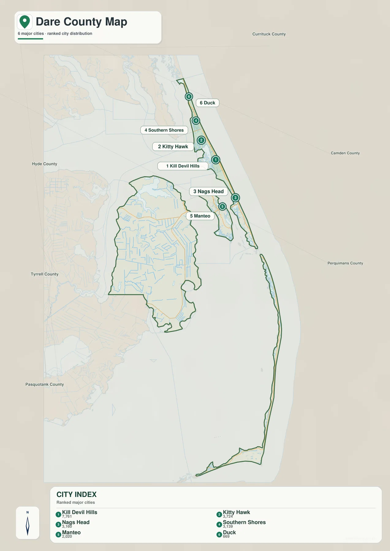
The city-index map focuses attention on six labeled places rather than trying to represent every settlement in the county. In the supplied index, Kill Devil Hills is listed at 7,761, followed by Kitty Hawk at 3,724, Nags Head at 3,160, Southern Shores at 3,139, Manteo at 2,020, and Duck at 669. Those numbers should be read as values printed on this map rather than as a claim about a newer population estimate. Their main value here is to show how the map ranks the named places and where those larger and smaller centers sit relative to one another.
Geographically, the first four coastal places are packed into a short north-south corridor. Duck and Southern Shores occupy the upper section, Kitty Hawk and Kill Devil Hills sit below them, and Nags Head continues the chain farther south. Manteo breaks that pattern because it is on Roanoke Island rather than directly on the oceanfront barrier strip. The contrast is useful: a reader looking only at the city names may assume they belong to one continuous urban area, while the map makes the water gaps and separate landforms obvious.
NC 12 and US 64 explain movement better than straight-line distance
NC 12 is the clearest road feature on the map because it follows the narrow Outer Banks corridor for such a long distance. In the north it links Duck, Southern Shores, Kitty Hawk, Kill Devil Hills, and Nags Head. The same route continues toward the long southern barrier-island section, where places such as Avon, Buxton, Frisco, and Hatteras appear in sequence. The road therefore mirrors the shape of the land: rather than cutting directly across the county, it follows the thin coastal strip that is actually available.
US 64 serves a different geographic purpose. It approaches from the mainland and connects the Manns Harbor side with the Roanoke Island area and the beach corridor, making it a useful reference for understanding how the county’s separated pieces are joined. The county map also labels NC 345 running toward Wanchese and shows a 264 route number on the mainland section. A destination that looks nearby across water may require a bridge and a specific road connection, while two beach towns that look far apart on the page may still be linked by the same north-south coastal route.
This is why Dare County is a good example of a place where a road map adds meaning to the boundary itself. The green county outline tells you what belongs to the county, but the orange road lines explain how people can move between its pieces. Manteo, Manns Harbor, Nags Head, and the Hatteras communities all make more sense once those road connections are considered alongside the water between them.
Albemarle and Pamlico sounds dominate the water map
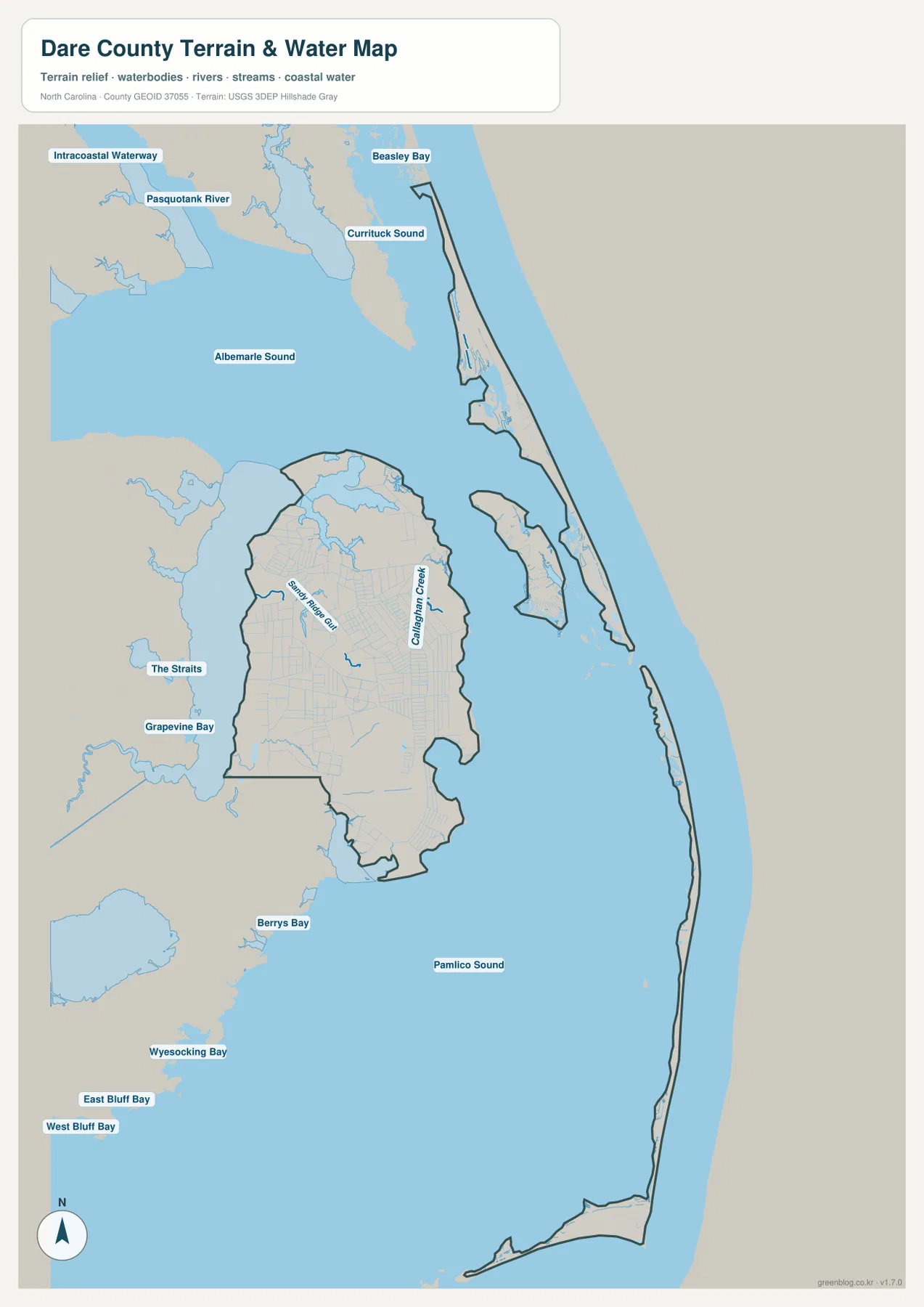
The water map changes the emphasis from towns and roads to the large bodies of water that define the county’s setting. Albemarle Sound fills much of the northern and northwestern side of the view, while Currituck Sound appears farther north along the upper Outer Banks. Pamlico Sound occupies a much larger area beside the southern barrier island and below Roanoke Island. Once those three water bodies are located, the county’s scattered land pieces become much easier to place.
The map also includes smaller named waters that add useful local detail. The Straits and Grapevine Bay appear west of the mainland portion, while Beasley Bay is labeled farther north. Around the broader map area, Berrys Bay, Wysocking Bay, East Bluff Bay, and West Bluff Bay provide additional orientation. Some of these labels are outside the Dare County boundary or immediately adjacent to it, so they should be treated as surrounding reference points rather than automatically counted as interior county features.
Small creeks crowd the mainland while open water borders the islands
The mainland portion has a noticeably different water pattern from the barrier islands. Smith River Gut and Callaghan Creek are labeled inside that broader land area, and many additional thin blue channels branch through the same section. Instead of one simple shoreline, the western part of the county is cut by numerous small waterways. That fine network is one reason the mainland looks much more intricate on the water map than it does on the city index.
The islands show the opposite pattern. Their interior water network is less visually dominant, but they sit between very large water bodies, so the land itself appears as a narrow ribbon. The northern beach strip lies between the ocean side and sounds such as Currituck and Albemarle, while the long southern strip is bordered on its inner side by Pamlico Sound. This contrast between open sound water and narrow island land is central to the county’s map shape.
The terrain background on this file is only a supporting visual layer. It should not be treated as a separate elevation map or as a source for precise height and slope measurements. For this package, the reliable takeaway is the arrangement of islands, mainland, sounds, bays, creeks, and channels—not survey-grade elevation information.
Choose the map by the question you are trying to answer
Start with the county map when you need a broad orientation. It is the best of the three for seeing the county boundary, the long distance from Duck to Hatteras, the position of Manteo and Manns Harbor, and the main road numbers on one page. It also provides enough surrounding geography to show that Dare County is not simply a single Outer Banks strip; the mainland and Roanoke Island pieces are important parts of the same county.
Use the city map when the settlement pattern is the main question. It removes much of the extra labeling and highlights the six ranked places, making it easier to compare the northern coastal chain with Manteo. This is especially helpful when a reader wants to know whether Kill Devil Hills, Kitty Hawk, Nags Head, Southern Shores, and Duck are spread throughout the county or clustered in one section. The answer is visually clear: they occupy a relatively compact northern beach corridor even though the county extends far to the south.
The water map is the better choice for explaining why those places and roads have the positions they do. It gives Albemarle Sound and Pamlico Sound enough visual weight to show how water separates the mainland, Roanoke Island, and the barrier islands. Used together, the three files provide a useful progression from county outline and roads, to named settlements, to the water bodies that shape the entire coastal layout. They are reference maps rather than parcel, flood-hazard, legal-boundary, or turn-by-turn navigation products.
Frequently Asked Questions
Does NC 12 connect every major part of Dare County?
NC 12 is the dominant route along the Outer Banks portion of the county, linking the northern beach communities and continuing toward Avon, Buxton, Frisco, and Hatteras. It does not by itself explain the whole county, because Manteo and Wanchese are on Roanoke Island and Manns Harbor is on the mainland. US 64 and other local connections are therefore important when the goal is to understand the full county rather than only the oceanfront strip.
What is the easiest way to distinguish Albemarle Sound from Pamlico Sound on the map?
Albemarle Sound occupies the broad northern side of the map, while Pamlico Sound fills the much larger area west of the southern barrier island and below Roanoke Island. Currituck Sound sits farther north near the upper Outer Banks. Locating those large waters first gives you a simple frame for placing the northern beach towns, Manteo, the mainland, and the Hatteras section.
Why is Kill Devil Hills ranked above Manteo on the city map?
The supplied city index lists Kill Devil Hills at 7,761 and Manteo at 2,020, so Kill Devil Hills appears higher in that ranking. Manteo remains the county seat, but administrative role and the numerical ranking used by the city map are different things. For county-government orientation, Manteo is the key reference; for comparing the relative size of the highlighted settlements, use the index values printed on the city map.
Sources and reference material
- Dare County – About Dare County – official county background and local orientation.
- U.S. Census Bureau TIGER/Line Shapefiles – official boundary, road, and geographic reference data.
- USGS National Hydrography – official hydrography reference for rivers, creeks, bays, and other water features.
Map File Information
The download contains the Dare County county map, city map, and water map as high-resolution A3 JPG files. Use the WebP images in the article for quick viewing and the JPG archive when you need larger files for printing, offline reference, or layout work.
- Included Files: Dare County general map, city map, and water map
- File Type: Three high-resolution A3 JPG files in one ZIP archive
- Intended Use: Printing, education, presentations, and map-based projects
Related Maps
Green Map creates custom-edited map images using open geographic data sources such as geoBoundaries, Natural Earth, OpenStreetMap, and government open data. These maps are edited visual materials, not raw data files, and are provided for education, documents, presentations, and graphic reference.