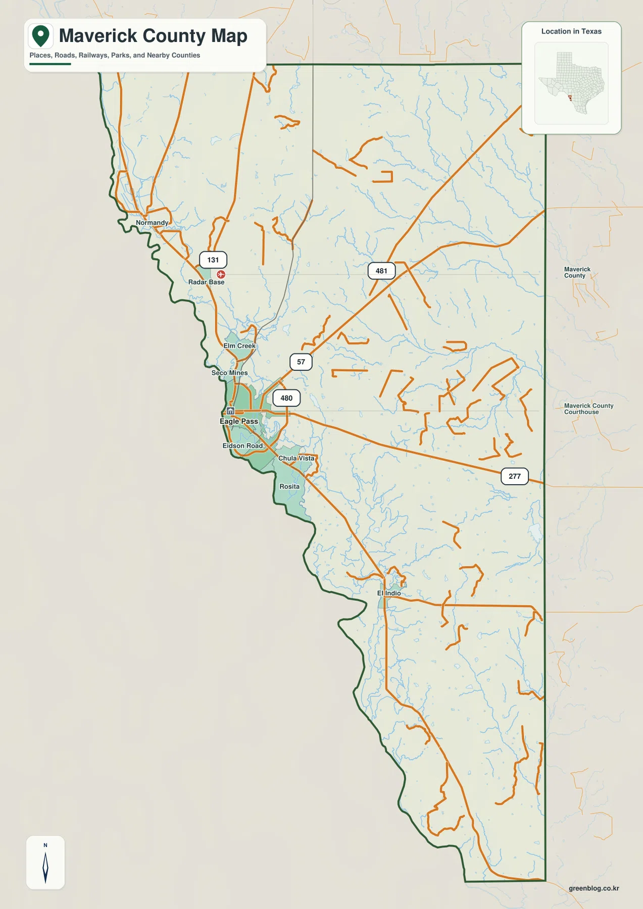
You can download four high-resolution A3 JPG maps of Maverick County, Texas, in one ZIP directly from this page. The package includes a general county map, a ranked city map, a terrain-and-water map, and an elevation map. Together they show Eagle Pass, Seco Mines, Eidson Road, Chula Vista, Rosita, El Indio, roads 57, 277, 480, 481, and 131, named creeks and small water bodies, and an actual elevation range of about 162 to 298 meters.
Eagle Pass and the Rio Grande side provide the clearest starting point. The urban area sits against the western border, while most of the county extends far to the east and south through a rugged network of hills and creek valleys. Route 277 leaves Eagle Pass toward the east, Route 57 heads northeast, and Route 480 is marked close to the city. Farther north, routes 481 and 131 provide additional inland references. The water and elevation maps reveal why those long road corridors cross a much more varied landscape than the general map first suggests.
Table of Contents
Eagle Pass and the Rio Grande side anchor the western edge
Eagle Pass is the largest developed area on the general map and sits directly beside the western border. Routes 57, 277, and 480 are all labeled around the city, giving three useful directions for orientation. North of the urban area, Seco Mines and Elm Creek are marked close to the border. Southward, Eidson Road, Chula Vista, and Rosita form a sequence of smaller settlement labels before the map continues toward El Indio.
Route 277 is especially helpful because it leaves Eagle Pass and runs across the southern-central interior. Route 57 angles northeast from the city, while Route 481 crosses farther north on a long diagonal. Route 131 appears near the northwestern Radar Base label. These roads do not form a single straight transportation spine; they spread through different parts of a broad county whose population center is concentrated near the border.
El Indio sits far south of Eagle Pass near the western side. The distance between the two labels makes the county’s north-south extent easy to judge. Normandy appears much farther north, and the interior between these places contains many thin drainage lines and smaller roads. The general map is therefore most useful when Eagle Pass is treated as the starting point rather than as a complete summary of the county.
The city index highlights Eagle Pass as the single ranked major city
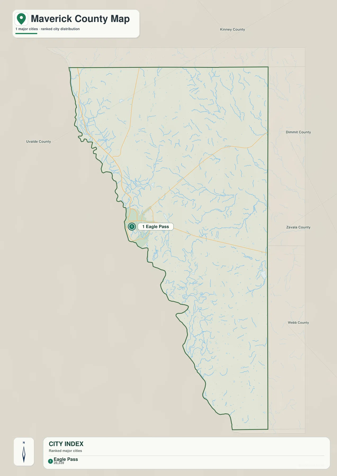
The ranked city map contains one major-city marker: Eagle Pass is number 1. The lower index also prints the value 28,339 beside the name. The supplied map does not identify a year for that figure, so this article treats it only as a value shown in the city index rather than presenting it as a confirmed current population count.
With most roads and small place labels removed, Eagle Pass appears clearly attached to the western border while the county stretches far inland. The large open interior on this simplified map should not be mistaken for featureless land. The terrain-and-water view fills the same space with branching creeks, and the elevation map shows repeated ridges and low valleys across the north, center, and south.
Kinney County is labeled to the north, Dimmit and Zavala counties to the east, and Webb County to the southeast. The western side is the Rio Grande border referenced by the package. The city map is useful for a quick Eagle Pass locator, while the general map is the better source for Seco Mines, Rosita, El Indio, and the numbered roads that cross the interior.
Salado Creek and Picosa Creek organize much of the central and eastern drainage
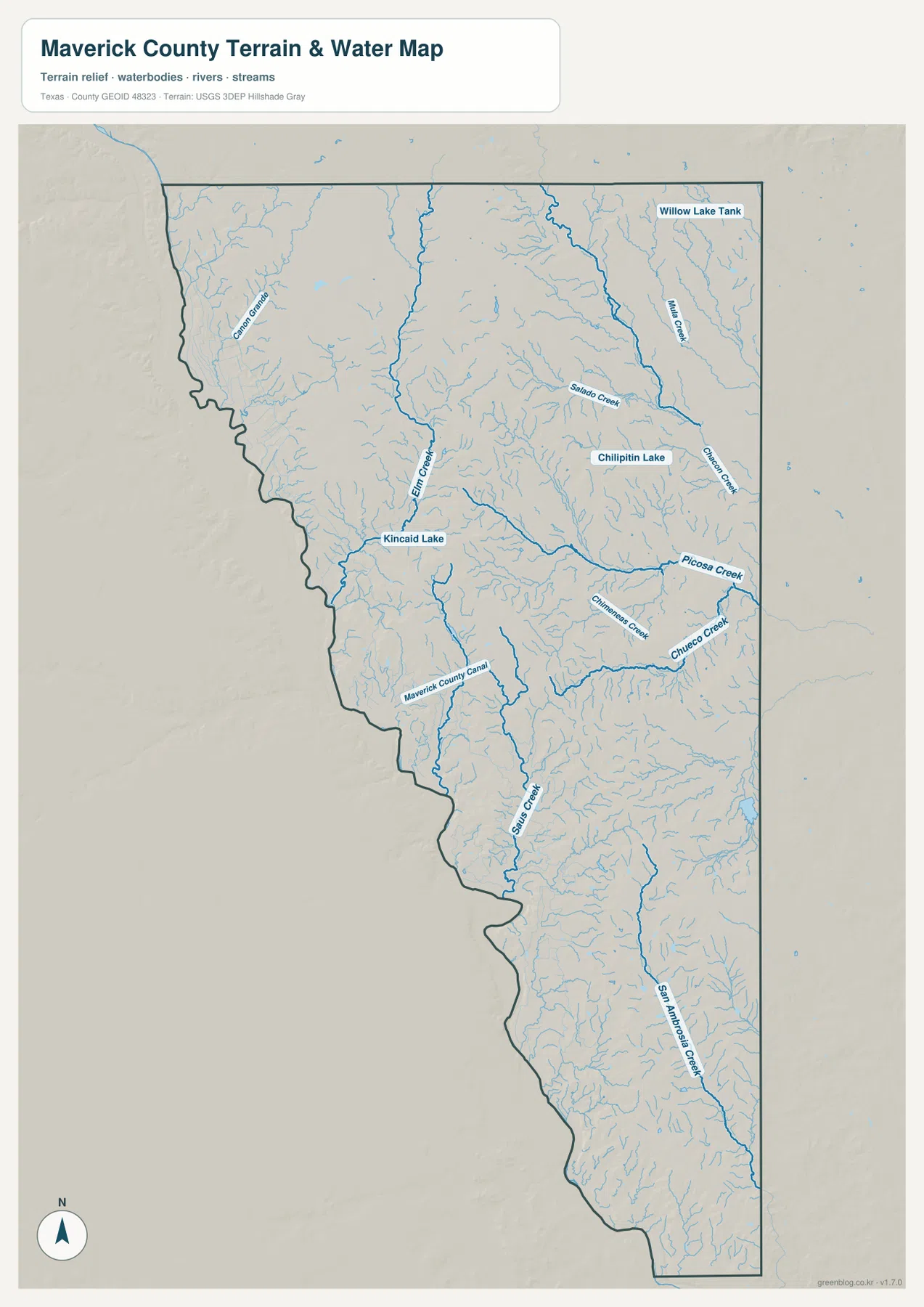
Salado Creek is one of the clearest named waterways in the north-central part of the terrain-and-water map. It bends across the interior toward a larger central drainage corridor. Picosa Creek is labeled farther south and approaches from the east. These two names provide a practical framework for locating the numerous smaller tributaries that cut through the eastern half of Maverick County.
South of Picosa Creek, Chimeneas Creek and Chueco Creek occupy separate valleys. Chueco Creek follows a strong east-to-west course toward the central drainage. Farther south, San Ambrosia Creek runs through a long valley in the southeastern portion. These connected creeks make the eastern interior far more dissected than the sparse settlement map suggests.
Elm Creek, Kincaid Lake, and the county canal add local water references near Eagle Pass
Elm Creek runs through the western-central part of the water map north of the Eagle Pass area. Kincaid Lake is labeled along the nearby drainage, while Chilipitin Lake appears farther east. Willow Lake Tank is marked in the northeast. These standing-water names are small compared with the overall creek network, but they provide useful reference points when matching the water layer back to roads and settlements.
Maverick County Canal is labeled southeast of the Eagle Pass area and stands out because its straighter course differs from the natural creek channels. The border side combines the Rio Grande setting referenced by the package with local creeks, small lakes, and an artificial canal, while the farther interior is dominated by branching drainage valleys. This water map is intended for geographic reference and should not be used as a flood-hazard, parcel-boundary, legal water-boundary, or navigation product.
Higher northern and central hills are cut by lower border and eastern valleys
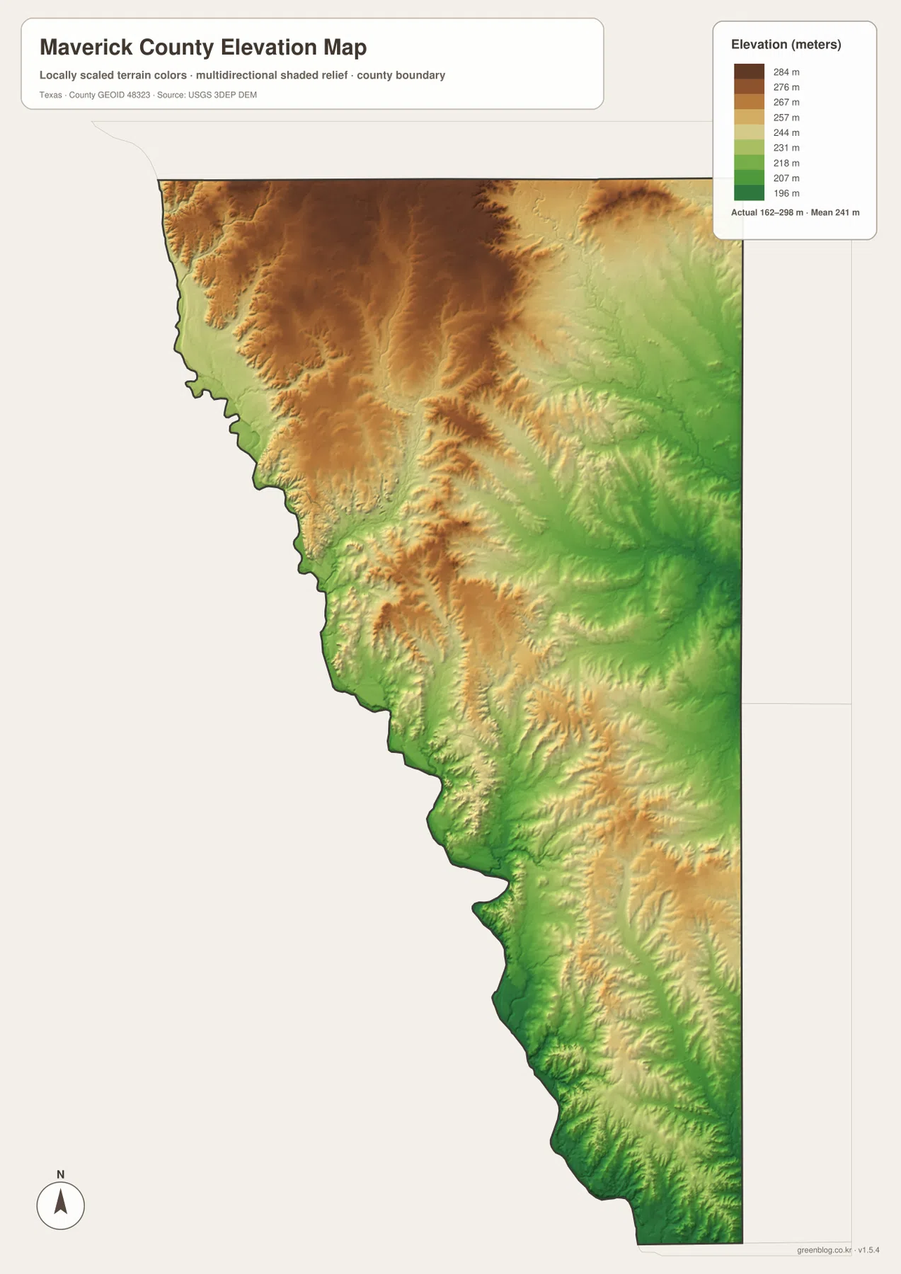
The elevation map reports an actual range of about 162 to 298 meters and a mean elevation of about 241 meters. The highest browns are concentrated across much of the north and north-central interior, with additional elevated ridges through the middle of the county. Lower greens appear along parts of the Rio Grande border and across eastern and southeastern drainage corridors.
The northern high ground is not a smooth plateau. Narrow valleys cut into the brown terrain, creating a strongly textured surface. When the elevation map is compared with the water map, Salado Creek and several eastern tributaries line up with lower green corridors between the ridges. Elm Creek creates another lower path toward the western border near the Eagle Pass area.
The southern half remains hilly, but low ground follows the border and major creek valleys. San Ambrosia Creek occupies one of the long southeastern corridors, while smaller tributaries create repeated fingers of lower terrain. The difference between the displayed minimum and maximum elevation is about 136 meters, enough to make ridge-and-valley relief obvious even without a mountain range.
The elevation layer is best used for relative terrain comparison rather than survey-grade or engineering-grade measurement. It helps connect Eagle Pass and the border side with the higher northern interior and the lower Salado, Picosa, Chueco, and southern creek valleys shown on the water map.
Following the roads inland from Eagle Pass reveals a much more rugged county
Start at Eagle Pass on the general map and follow Route 57 or Route 277 into the county. The road view initially emphasizes long orange lines across open terrain. On the water map, the same interior fills with Elm Creek, Salado Creek, Picosa Creek, Chueco Creek, and many smaller tributaries. The elevation map adds repeated ridges and green valleys, showing that the inland landscape is far from flat or empty.
The southern El Indio direction provides another useful comparison. Settlement labels remain close to the western border, while San Ambrosia Creek and other drainage lines cross the interior. The elevation map shows low ground along parts of the border but hillier terrain immediately inland. The western boundary is therefore best understood as a river-and-valley landscape rather than as a simple straight edge on a county map.
Use the ranked city map when only Eagle Pass needs to be located, the general map for roads and smaller communities, the terrain-and-water map for named creeks, lakes, and the canal, and the elevation map for the contrast between high interior hills and lower drainage corridors. Small labels are often easier to inspect in the downloadable high-resolution JPG files than in the browser previews.
Frequently Asked Questions
Which city is highlighted on the Maverick County city map?
Eagle Pass is the single ranked major city on the supplied city map. It lies along the western border and is easy to locate on the general map near routes 57, 277, and 480. The city index also prints 28,339, but no year is shown, so this article does not present that figure as a confirmed current population count.
Which named water features are easiest to identify?
Salado Creek and Picosa Creek provide strong central and eastern references. Elm Creek and Kincaid Lake are closer to the Eagle Pass side, while Chimeneas Creek, Chueco Creek, Maverick County Canal, and San Ambrosia Creek are also labeled on the supplied water map.
What elevation range is shown for Maverick County?
The supplied elevation map reports an actual range of about 162 to 298 meters and a mean of about 241 meters. The north and central interior contain much of the higher terrain, while lower corridors follow parts of the border and the eastern and southeastern creek valleys.
Sources and Reference Data
- U.S. Census Bureau TIGER/Line Shapefiles — official county-boundary and road geometry for geographic reference.
- USGS National Hydrography — official resources for creeks, lakes, canals, and other water features.
- USGS 3D Elevation Program — official elevation resources used for terrain information.
- USGS The National Map Viewer — an official viewer for comparing geographic layers.
Map File Information
Download four high-resolution A3 JPG maps of Maverick County, Texas, in one ZIP file.
- Included Files: county map, ranked city map, terrain and water map, elevation map
- File Type: JPG
Related Maps
- Uvalde County Texas map
- Zavala County Texas map
- Webb County Texas map
- Val Verde County Texas map
- Atascosa County Texas map
Green Map creates custom-edited map images using open geographic data sources such as geoBoundaries, Natural Earth, OpenStreetMap, and government open data. These maps are edited visual materials, not raw data files, and are provided for education, documents, presentations, and graphic reference.