Hemphill County sits in the eastern Texas Panhandle, where the Canadian River cuts a broad, low corridor through higher uplands. The Hemphill County Map on this page is most useful when Canadian, the main highways, the river, and the deeply incised tributaries are considered together rather than as separate labels. You can also download the original A3 high-resolution JPG files for the county, city, water, and elevation maps in one ZIP after reviewing the web versions below.
Table of Contents
A county organized around the Canadian River corridor
The general county map places Canadian near the northwestern side of the county’s center, close to the Canadian River and the meeting of U.S. 60 and U.S. 83. From that junction, Highway 305 reaches north toward Glazier, while numbered roads such as 20, 4, and 30 serve the eastern side. Farther south, 33, 277, 26, 27, and 29 appear across a much more open road pattern. The long gaps between routes and named places are an important part of the map: this is not a county where dense urban streets fill the interior.
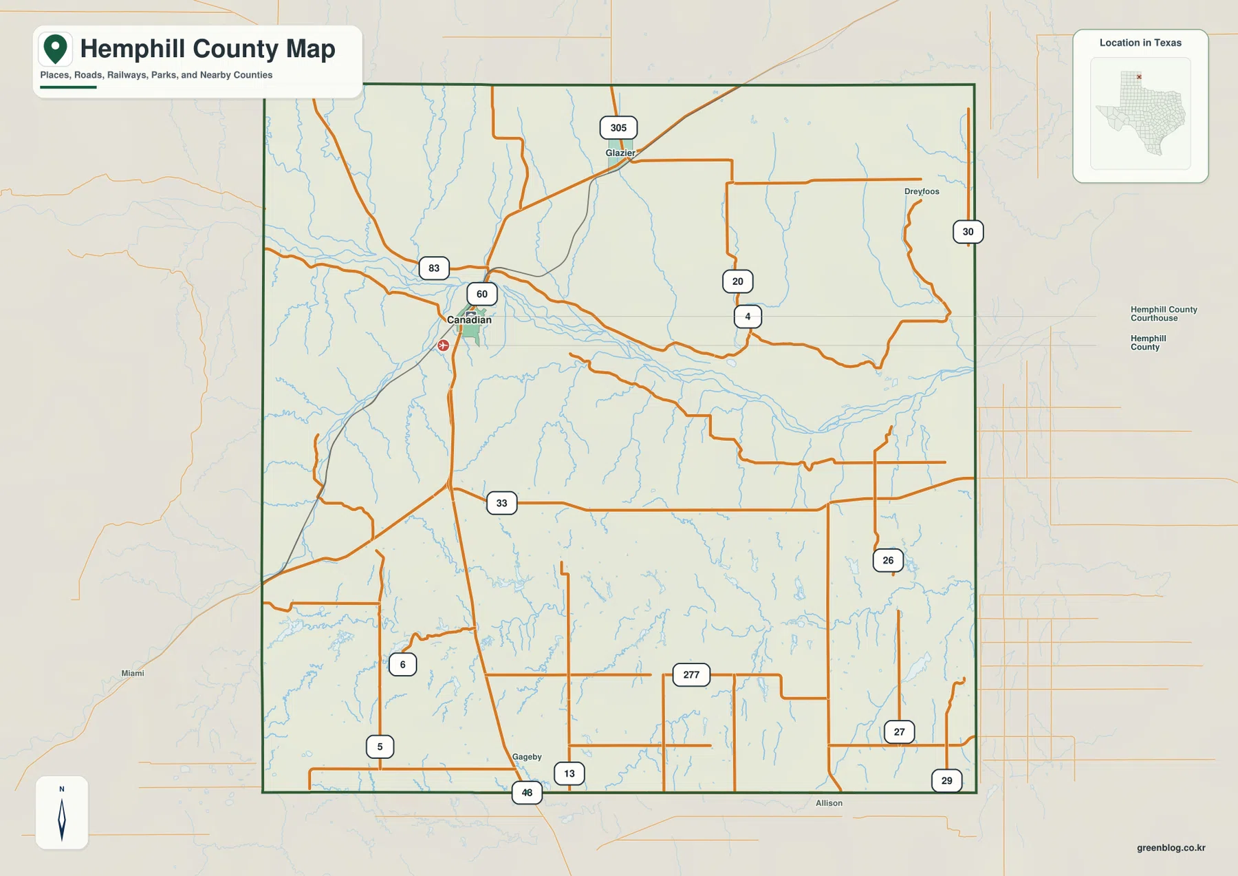
The river gives the northern half of the county a very different appearance from a simple rectangular Panhandle grid. It bends eastward through a broad valley, receives numerous short tributaries, and is crossed or approached by roads that must respond to the broken terrain. Canadian is positioned where this natural corridor and the highway network come together, which makes it a better starting point for reading the county than the geometric boundary alone.
Canadian stands out in a sparsely labeled settlement pattern
The supplied city map ranks only one major city: Canadian. Its city index shows the number 2,241 beside the name. Because that number is part of the provided map, it is best treated here as the map’s own city-index value rather than as a claim about the latest population estimate. Visually, the important point is that Canadian is the single dominant urban reference while most of the county remains open and lightly labeled.
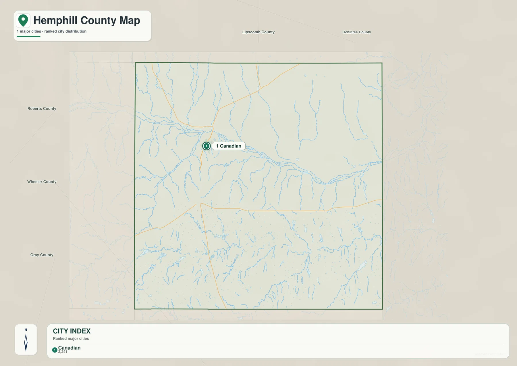
Canadian’s transportation position explains why it is so prominent. U.S. 60 follows the same broad east-west part of the county as the Canadian River corridor, while U.S. 83 provides the stronger north-south connection through town. Glazier appears farther north near the road network, and labels such as Gageby and Allison appear near the southern edge or just beyond it. Reading these places together makes the county’s scale easier to judge: even the named reference points are separated by substantial rural distance.
Canadian River above, Washita tributaries below
The terrain-and-water map adds much more detail than the road map. Canadian River is the boldest water feature in the northern half. Big Timber Creek joins from the northwest, Persimmon Creek descends from the north-central uplands, and Red Deer Creek is labeled west of Canadian. Lake Marvin is also shown close to the Canadian River corridor. The numerous fine blue tributaries explain why the terrain around the river looks dissected rather than flat.
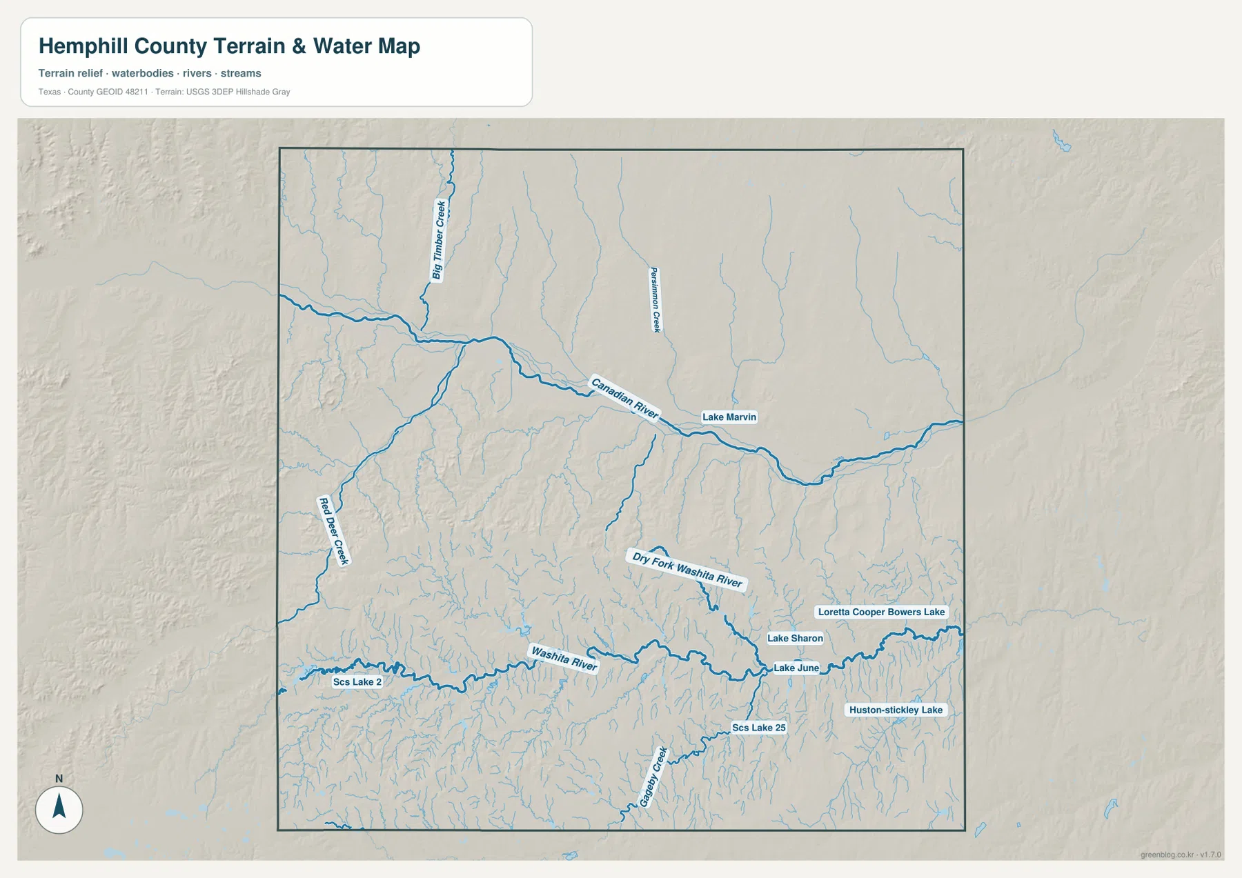
South of that main river corridor, the named network changes. Washita River and Dry Fork Washita River run across the lower half, with Gageby Creek feeding the system from the south. The map also labels Lake Sharon, Lake June, Loretta Cooper Bowers Lake, Houston-stickley Lake, and several SCS lakes. Looking at the northern and southern halves separately is helpful because the drainage does not read as one uniform set of streams; each part of the county has its own visible valley pattern.
Elevation from about 659 to 916 meters
The elevation map states an actual range of about 659 to 916 meters, with a mean near 771 meters. The Canadian River valley is immediately recognizable as the long green lowland crossing the northern half of the county. Another low corridor appears toward the southeast. In contrast, the southwest and parts of the western edge rise into brown and tan uplands, producing one of the clearest high-to-low contrasts in the map set.
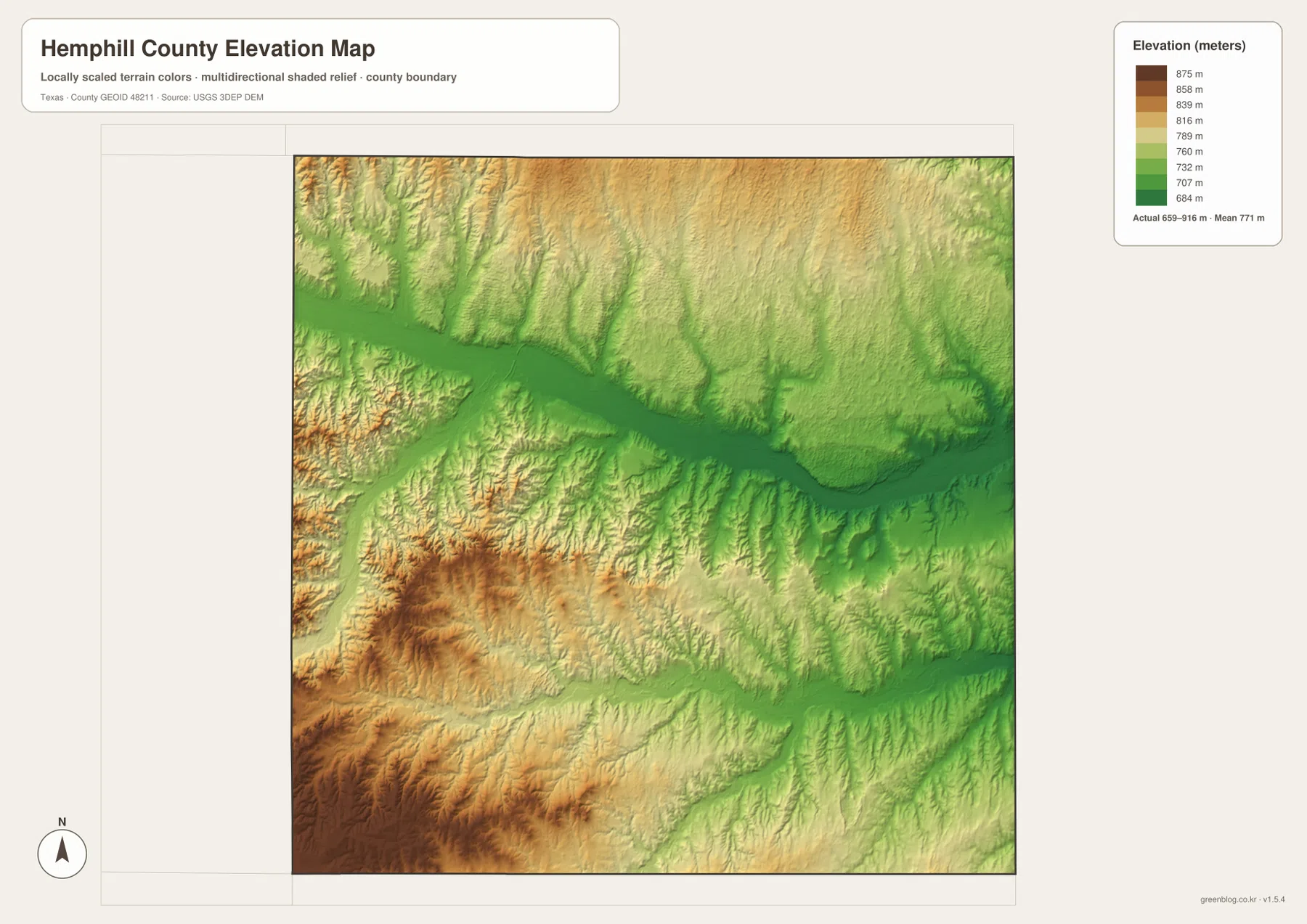
This relief also helps explain details visible on the other maps. Canadian sits close to the lowered river corridor, while the surrounding tributaries cut back into higher ground from both sides. The southwest is not simply a smooth plateau; shaded relief shows many smaller draws and ridges. As a result, the county combines the broad visual openness associated with the Panhandle with a much more rugged river landscape than a plain road map might suggest.
Choosing the most useful map for the task
Use the county map when the priority is roads, named places, and the county boundary. The city map removes much of that detail and makes Canadian’s position easy to recognize. For stream names, lakes, and valley relationships, the water map is the better reference, while the elevation map is the clearest choice for comparing the low river corridors with the higher southwest. Moving between these views is more effective than expecting one image to answer every geographic question.
A practical sequence for classroom work or regional research is to locate Canadian and U.S. 60/83 first, trace the Canadian River next, and then open the elevation map to see why the river corridor stands out. If the project focuses on drainage, the water map can then be used to follow Big Timber Creek, Persimmon Creek, the Washita River system, and the named lakes. The downloadable JPG files are intended for larger printing and closer inspection than the web previews.
Frequently Asked Questions
Where is Canadian on the Hemphill County map?
Canadian is shown near the northwestern side of the county’s center, close to the Canadian River and the junction of U.S. 60 and U.S. 83. It is also the only ranked major city on the supplied city map.
Why does the Canadian River corridor appear so low on the elevation map?
The elevation map shows a long green lowland following the river while the surrounding uplands rise to higher colors. The river and its tributaries occupy incised valleys, creating a strong contrast with the higher western and southwestern terrain.
What is included in the downloadable ZIP?
The ZIP contains A3 high-resolution JPG files for the county map, city map, water map, and elevation map. They are the larger files intended for printing or closer viewing.
Map File Information
The ZIP contains A3 high-resolution JPG versions of the Hemphill County county, city, water, and elevation maps.
- Included Files: County map, city map, water map, elevation map
- File Type: JPG
Related Maps
- Roberts County Texas map
- Wheeler County Texas map
- Navarro County Texas map
- Ochiltree County Texas map
- Rockwall County Texas map
Map data and reference sources
For additional boundary and road data, see the U.S. Census Bureau TIGER/Line Shapefiles. Hydrography can be checked through USGS National Hydrography, while terrain and elevation data are available from the USGS 3D Elevation Program. The USGS The National Map Viewer is useful for viewing several geographic layers together.
Green Map creates custom-edited map images using open geographic data sources such as geoBoundaries, Natural Earth, OpenStreetMap, and government open data. These maps are edited visual materials, not raw data files, and are provided for education, documents, presentations, and graphic reference.