Haralson County sits in western Georgia, where Buchanan serves as the county seat while Bremen, Tallapoosa, and Waco form other important settlement references across the south and west. The maps on this page make it possible to separate those places from the county’s rivers and rolling terrain. The general map shows the four principal place labels with numbered roads and streams. A city-connections view uses Bremen as a hub, the water map traces the Tallapoosa River, Little River, named creeks, lakes, and reservoirs, and the elevation map shows an actual range of about 279 to 476 meters. After reviewing the web previews, readers can download four high-resolution A3 JPG originals together in one ZIP.
Buchanan and Bremen are useful for different kinds of orientation. Buchanan is the administrative center near the middle of the county, while Bremen anchors the southern city-connections map. Tallapoosa lies farther west, Waco is close to Bremen, and much of the northern and eastern county contains more stream valleys and ridges than urban shading. The Tallapoosa River follows lower western ground, whereas stronger ridges rise across the east and southeast. Reading the settlement, water, and elevation views together gives Haralson County a much clearer structure than a simple boundary map alone.
Table of Contents
Buchanan, Bremen, and the County Road Framework
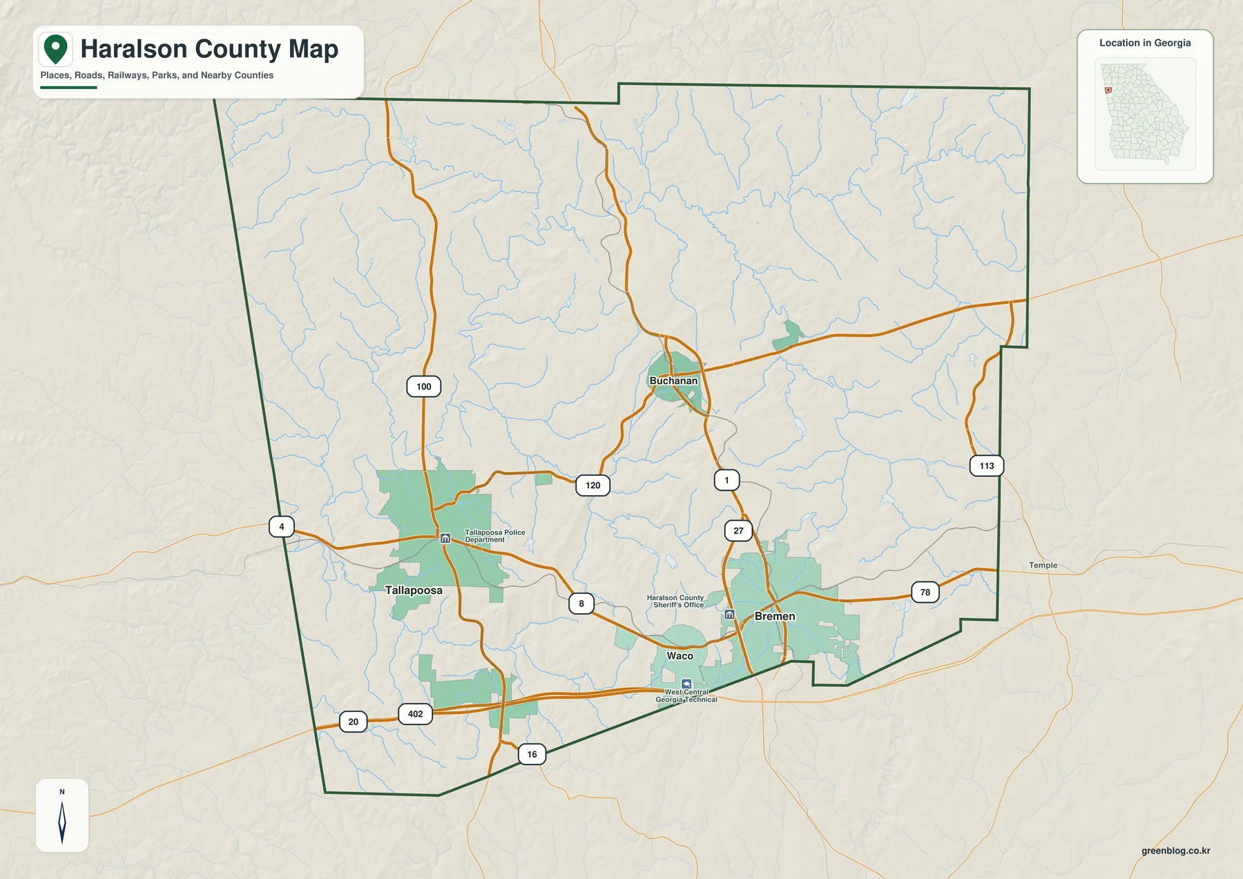
Buchanan appears near the central part of the county and provides the strongest administrative reference. Routes 1 and 27 extend south from the Buchanan area toward Bremen, while Route 120 reaches west and southwest toward Tallapoosa. Route 100 is an important north-south marker in the western half. On the eastern side, Route 113 provides another boundary-side reference, and Route 78 runs across the southeastern part of the county. The map is most useful at this scale for understanding direction and place relationships rather than for following individual streets.
The southern corridor around Bremen and Waco contains a denser road pattern. Route 8 crosses from the Tallapoosa side through Waco toward Bremen, while the 20/402 corridor forms a strong east-west line close to the southern edge. Route 16 appears farther south as another reference. The map also labels the Haralson County Sheriff’s Office, the Tallapoosa Police Department, and West Central Georgia Technical College, which help place the developed areas without turning the map into a detailed street or service directory.
Tallapoosa stands out as a broad developed area in the west, Bremen as another strong urban area in the southeast, and Waco as a smaller place between them. Buchanan remains the county seat even though its urban footprint is not the largest on the map. That distinction is useful for readers: administrative importance and visible development size are not the same thing. The general map is therefore a good first reference for seeing how the county seat, larger southern and western communities, and road network fit together.
Straight-Line City Connections from Bremen
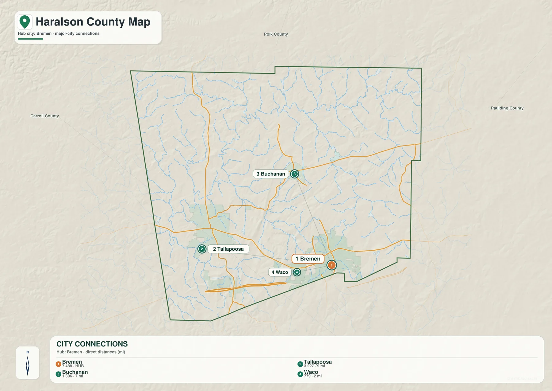
The city-connections map simplifies the county and uses Bremen as its hub. Its panel lists Bremen at 7,488, Tallapoosa at 3,227, Buchanan at 1,306, and Waco at 779. These numbers are the values printed on the supplied graphic and are included to explain its ranking; they should not be treated as newly verified population estimates for this article. Current demographic figures can be checked through the Census QuickFacts source in the reference section.
The connector labels show Tallapoosa about 9 miles from Bremen, Buchanan about 7 miles away, and Waco about 2 miles away. They are straight-line distances, not driving mileage. Actual road travel can be longer because roads bend through the terrain and the exact start and end points vary. Even so, the lines provide a clear visual comparison: Waco sits very close to Bremen, Buchanan is farther north, and Tallapoosa is the more distant western connection.
Polk County, Carroll County, and Paulding County are labeled outside Haralson County for regional orientation. Those labels are not intended as a survey product, but they help place the four highlighted cities within western Georgia. The map also reinforces an important difference in the county’s settlement pattern. The principal places are divided between the south and west rather than forming a single compact cluster around Buchanan.
| Place | Displayed value | Straight-line distance from Bremen | General direction |
|---|---|---|---|
| Bremen | 7,488 | hub | southern county |
| Tallapoosa | 3,227 | about 9 mi | west-northwest |
| Buchanan | 1,306 | about 7 mi | north |
| Waco | 779 | about 2 mi | nearby to the west |
Tallapoosa River, Little River, and Named Creek Valleys
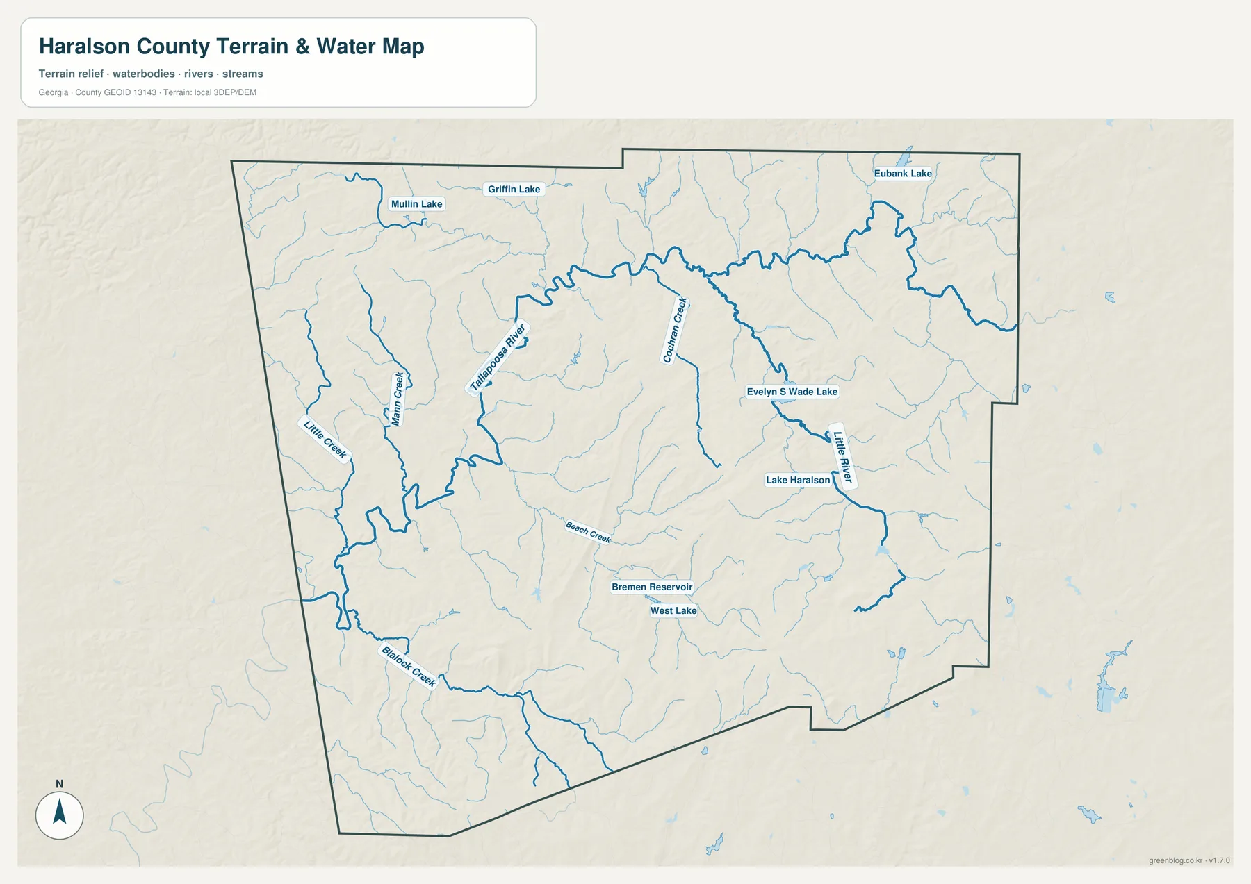
The Tallapoosa River is the strongest large water feature on the map. It enters the northwestern side and follows lower western ground before continuing toward the southwest. Numerous smaller channels feed into the same broad valley, which helps explain why the Tallapoosa area appears crossed by so many blue lines on the general map. When roads and city shading are removed, the western part of Haralson County looks much more like a river landscape than a simple sequence of towns.
Mann Creek and Little Creek provide named references on the western side, while Blalock Creek follows a southern valley. Beach Creek appears closer to the middle of the county. Farther east, Corinth Creek descends through a long north-south corridor, and Little River occupies another strong valley in the east and southeast. These waterways show that the county is not organized by the Tallapoosa River alone; the eastern half contains separate drainage corridors divided by ridges.
Several small lakes and reservoirs make local positions easier to identify. Mullin Lake and Griffin Lake appear near the northwestern side, while Eubank Lake lies in the northeast. Evelyn S Wade Lake and Lake Haralson are labeled in the eastern interior. Near Bremen, the map shows Bremen Reservoir and West Lake. These waters differ in size and purpose, so their main value here is as named map references within a dense network of small tributaries.
This water map is intended for county-scale orientation, not for deciding parcel flood status, shoreline ownership, channel depth, or legal water access. Those questions require current specialized records. For ordinary map reading, the useful relationships are the Tallapoosa River valley in the west, Corinth Creek and Little River in the east, Blalock Creek in the southwest, and the cluster of small lakes and reservoirs around the eastern and southern parts of the county.
Elevation from About 279 to 476 Meters
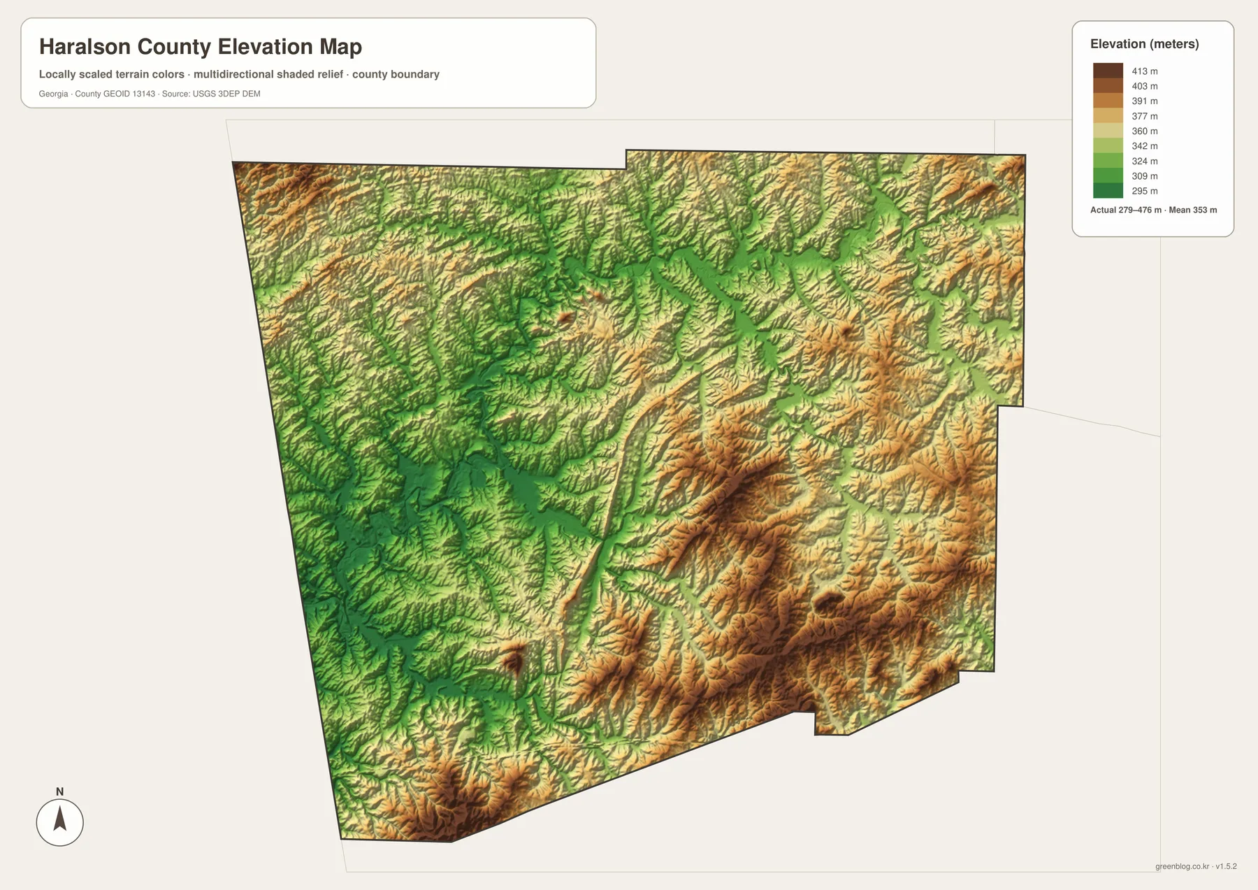
The supplied elevation map reports an actual range of approximately 279 to 476 meters, with a mean of 353 meters. Broad green areas dominate much of the west and west-central interior, while tan and brown ridges become more prominent toward the east and southeast. A difference of roughly 200 meters between the mapped low and high points is enough to create a strong ridge-and-valley texture even though Haralson County is not a high mountain county.
The Tallapoosa River corridor corresponds closely with the lower western terrain. Green valleys spread through the same part of the county where the water map shows the river and multiple tributaries. East of that low area, long narrow ridges rise through the central and southeastern interior. The contrast helps explain why watercourses often follow curved lower paths while roads cross or skirt higher ground.
The eastern half is generally higher, but it is not one flat upland. Corinth Creek, Little River, and smaller unnamed channels cut green valleys between the stronger ridges. Local high areas also appear along portions of the northwest and southwest edges, so the county cannot be reduced to a simple east-high/west-low slope. A better description is a broad low western river zone interrupted and bordered by repeated ridges and tributary valleys.
The relief colors are designed for broad geographic comparison rather than survey or engineering work. An exact elevation for a building site, drainage plan, road design, or property survey requires finer elevation data and, where appropriate, field measurements. For classroom geography, local research, or a presentation, the 279–476 meter range clearly shows the relationship between the lower Tallapoosa corridor and the higher ridged terrain farther east.
Buchanan’s County-Seat Role and the Bremen–Tallapoosa Corridor
The source article in the package identifies Haralson County as established in 1856 and notes Interstate 20 access, manufacturing, rail history, and ties to the Alabama-border region as parts of the county’s local context. The four maps here do not measure industry, rail activity, or economic growth. Instead, they provide the geographic framework behind those subjects: Buchanan as the county seat, stronger developed areas around Bremen and Tallapoosa, major routes in the south, the Tallapoosa River system, and rolling relief between about 279 and 476 meters.
The general map is the most useful starting point when roads, places, and the county outline all matter. The Bremen-centered city map provides a cleaner comparison of the four highlighted communities and their straight-line spacing. The water map is the better reference for the Tallapoosa River, Little River, Corinth Creek, and named lakes, while the elevation map explains the low western valleys and higher eastern ridges. Because all four views use the same county boundary, they can be compared directly in a class, report, or presentation.
The Bremen–Buchanan relationship is a good example of how the maps complement one another. Routes 1 and 27 connect the two areas on the general map, and the city view places Buchanan about 7 straight-line miles north of Bremen. Moving west toward Tallapoosa brings the major river valley into the picture, while heading east leads into stronger ridged terrain and the Little River side. These relationships make Haralson County easier to understand as an interconnected landscape rather than as a list of place names.
Frequently Asked Questions
Is Bremen or Buchanan the county seat?
Buchanan is the county seat. Bremen is used as the hub on the supplied city-connections map because that graphic compares Bremen with Tallapoosa, Buchanan, and Waco.
Are the 2-, 7-, and 9-mile labels driving distances?
No. The city map shows straight-line distances from Bremen: about 2 miles to Waco, 7 miles to Buchanan, and 9 miles to Tallapoosa. Actual driving mileage depends on the roads and exact start and end points.
Which water features are named on the map?
The map labels the Tallapoosa River, Little River, Mann Creek, Corinth Creek, Little Creek, Beach Creek, and Blalock Creek. It also identifies Mullin Lake, Griffin Lake, Eubank Lake, Evelyn S Wade Lake, Lake Haralson, Bremen Reservoir, and West Lake.
What is included in the A3 map ZIP?
The archive contains four large JPG originals covering the general county reference, Bremen-centered city connections, waterways, and elevation. Keeping the themes separate makes roads, place names, water labels, and relief easier to read when printed or placed in a document.
Map File Information
Haralson County A3 Map Files
- Included Files: 4 high-resolution A3 JPG map files shown in this article
- File Type: JPG files in a ZIP archive
- Intended Use: Printing, education, presentations, and map-based projects
Related Maps
Haralson County Data and Reference Sources
- U.S. Census Bureau QuickFacts: Haralson County – current official county statistics
- Haralson County official website – county administration and local information
- New Georgia Encyclopedia: Haralson County – county history and regional background
- Census TIGER/Line boundary resources – Haralson County and neighboring-county reference geometry
- USGS hydrography resources – reference data for the Tallapoosa River, Little River, creeks, lakes, and reservoirs
- USGS 3DEP elevation resources – source elevation data for comparing the 279–476 meter terrain range
Green Map creates custom-edited map images using open geographic data sources such as geoBoundaries, Natural Earth, OpenStreetMap, and government open data. These maps are edited visual materials, not raw data files, and are provided for education, documents, presentations, and graphic reference.