Greene County sits in east-central Georgia, where Greensboro anchors the road network while the Oconee River and a broad reservoir shoreline shape much of the western and southwestern landscape. Five cities stand out on the supplied city map—Greensboro, Union Point, Siloam, Woodville, and White Plains—but they occupy only part of a county filled with creeks, small lakes, and rolling terrain. The map set on this page separates those features instead of crowding them into one image. A general reference view shows places and numbered roads, the city map ranks the five major cities, the water view traces the Oconee and several eastern river forks, and the elevation map shows an actual range of about 117 to 227 meters. High-resolution A3 JPG versions of all four views are available together in the downloadable ZIP.
Greensboro is the easiest point from which to understand the county. It lies slightly west of center, with Union Point farther east, Siloam to the southeast, Woodville to the northeast, and White Plains farther south. The western side tells a different story: the Oconee River follows a broad low corridor, and reservoir arms extend deep into the southwest. Elevation rises toward much of the eastern half, where narrow green stream valleys cut through tan and brown hills. Reading the road, water, and relief maps together therefore reveals a county divided not only by municipal boundaries but also by a strong west-to-east contrast between river lowlands and rolling higher ground.
Table of Contents
Greensboro at the County’s Main Road Crossroads
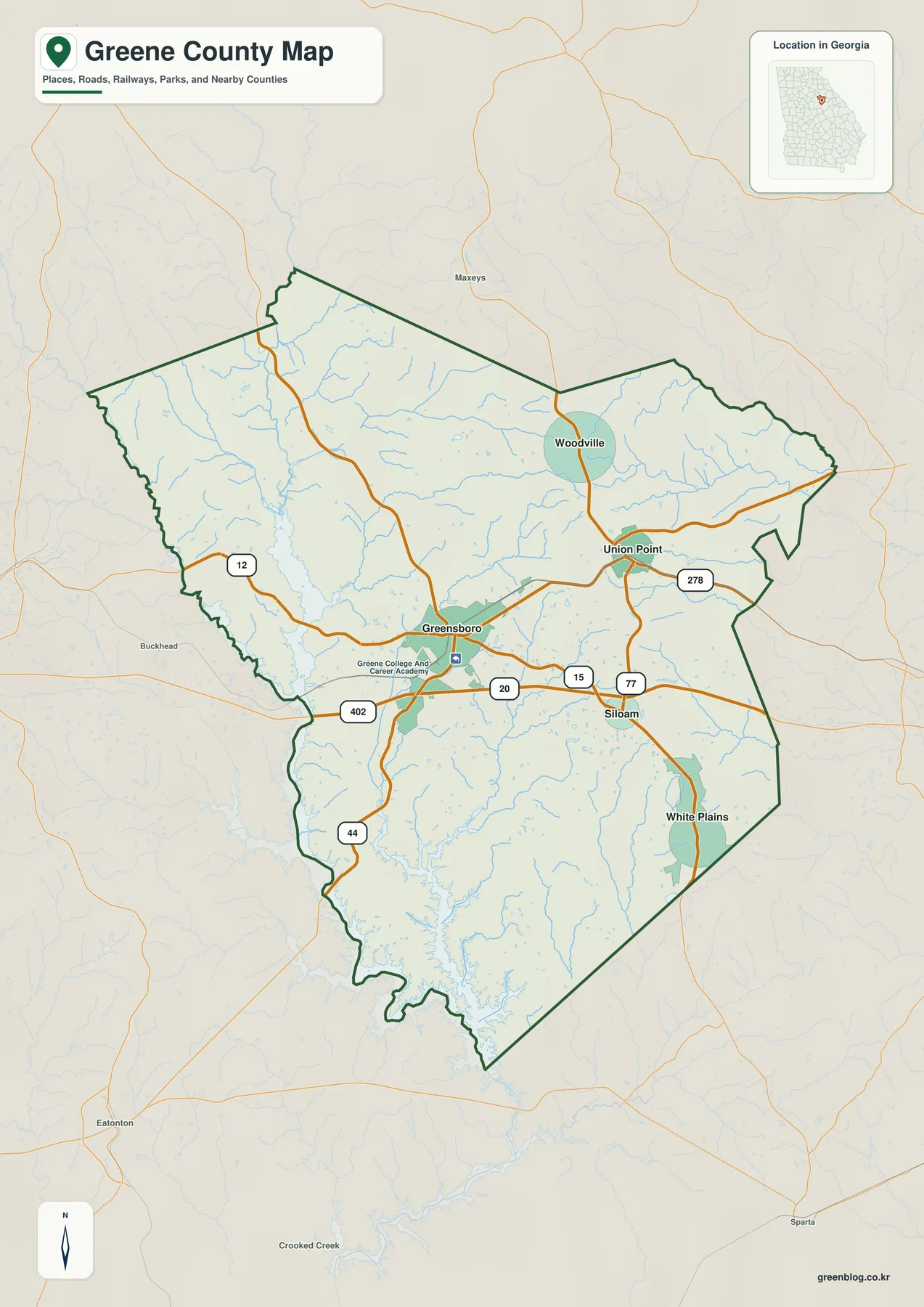
The general map gives Greensboro the strongest road context. Route 12 enters from the west and approaches the Greensboro area, while the east-west 20/402 corridor runs just south of the city and continues toward Union Point and Siloam. Routes 15 and 77 are visible east of Greensboro, Route 278 appears near Union Point, and Route 44 turns south from the Greensboro area toward the large water bodies in the lower part of the county. These labels are useful for county-scale orientation because they show the broad directions in which the main communities connect without trying to reproduce every local street.
The settlement pattern is weighted toward the eastern half. Greensboro sits in the central-western interior, Union Point lies farther east, Siloam is southeast, Woodville is north of Union Point, and White Plains is near the southeastern side. The west and southwest contain fewer major city labels and much more visible water. That difference is important: Greene County is not a single compact urban cluster centered on Greensboro. It has an administrative and road center near the middle, several smaller municipalities across the east, and a substantial western landscape organized around the Oconee River and reservoir shoreline.
Greene College and Career Academy is labeled near Greensboro and provides another local reference point. Outside the boundary, places such as Buckhead, Maysville, Eatonton, and Sparta help orient the county within the surrounding part of Georgia. Those outside labels are not part of a legal boundary survey; they simply make the regional setting easier to understand. The general map works best when the question involves place names, major routes, county shape, and waterways together. Site-level addresses or current driving directions require a more detailed navigation source.
Five Ranked Cities from Greensboro to White Plains
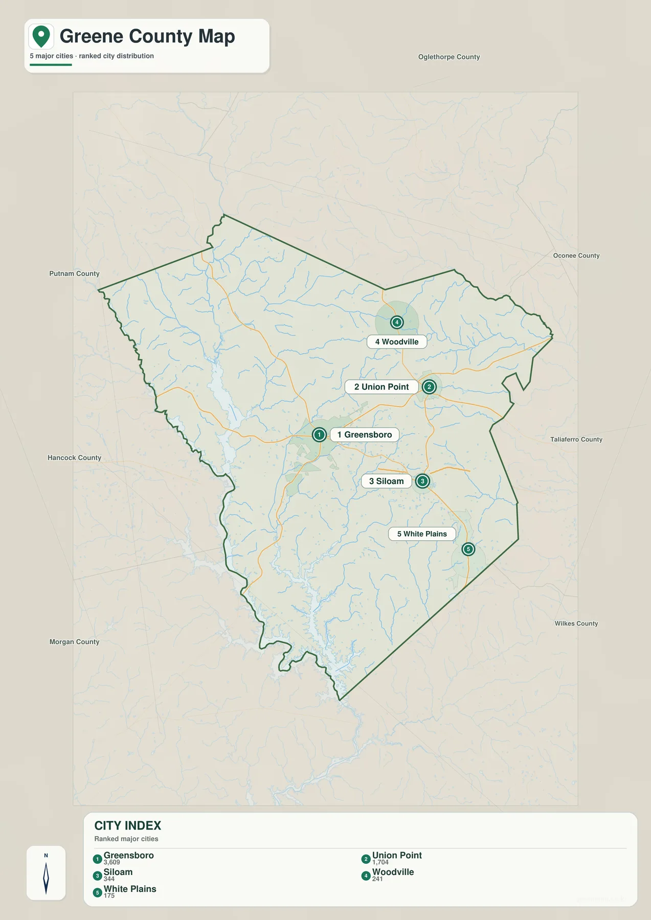
The city map strips away most road and terrain detail and highlights five places. Its CITY INDEX lists Greensboro at 3,609, Union Point at 1,704, Siloam at 344, Woodville at 241, and White Plains at 175. These are the values printed on the supplied map and are repeated here only to explain the graphic’s ranking. They are not newly calculated population estimates for this article. Current demographic figures should be checked against the Census QuickFacts source in the reference section.
Geography matters more than the ranking alone. Greensboro occupies the central-western interior, while Union Point and Siloam follow the broad eastward road pattern. Woodville sits well north of those two cities, and White Plains lies farther south. The arrangement does not form a straight chain or a neat circle around the county seat. Instead, the five labels spread across the eastern and central parts of Greene County, leaving the reservoir-dominated southwest without a city of comparable map prominence.
Neighboring county labels add useful orientation. Putnam, Hancock, Morgan, Oglethorpe, Oconee, Taliaferro, and Wilkes counties appear around the map frame. Greensboro is relatively central within Greene County, but Union Point and Siloam sit closer to the eastern county side, while the western water corridor faces toward Putnam and Morgan County territory. The city view is therefore a good tool for understanding municipal distribution, but it becomes more informative when paired with the water map that explains what occupies the large spaces between those cities.
| Map rank | City | Displayed value | General position |
|---|---|---|---|
| 1 | Greensboro | 3,609 | central-western interior |
| 2 | Union Point | 1,704 | east-central |
| 3 | Siloam | 344 | southeast |
| 4 | Woodville | 241 | northeast |
| 5 | White Plains | 175 | southern/eastern side |
Oconee River Lowlands and the Eastern River Forks
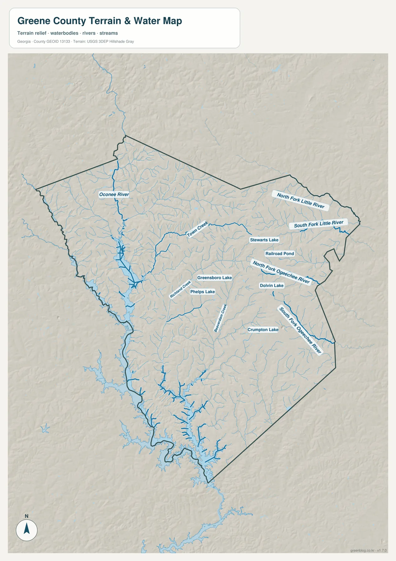
The Oconee River is the clearest large water feature on the western side of the county. It enters from the northwest, follows a broad low corridor west of Greensboro, and continues south into an area where the shoreline widens into long reservoir arms. The existing source article identifies Lake Oconee as an important part of Greene County’s modern setting, and the supplied map visually supports that description through the extensive water surface in the southwest. This western water landscape is one of the strongest differences between Greene County and neighboring inland counties without a comparable reservoir edge.
The eastern half has a different drainage pattern. North Fork Little River and South Fork Little River are labeled across the northeast and east, while North Fork Ogeechee River and South Fork Ogeechee River occupy separate valleys farther south. Town Creek extends across the central-northern interior and provides a useful connection between the Greensboro area and the eastern stream network. Richland Creek is another named reference south and east of Greensboro. Together, these features show that the county is not drained by one river alone; the western Oconee corridor and the eastern river forks divide the landscape into several distinct water systems.
Smaller standing waters make the interior easier to locate. Greensboro Lake and Phelps Lake are labeled southeast of the county seat. Stewarts Lake and Railroad Pond appear farther east, Dolvin Lake is marked nearby, and Crumpton Lake lies in the southeastern half. These features differ in size and purpose, so the map should not be read as if every named water body were equivalent. Their value here is positional: they create local reference points within a county where numerous small tributaries can otherwise look very similar.
This water view is a geographic overview rather than a parcel, flood-insurance, shoreline-access, or boating chart. Property-level decisions require the appropriate current local or agency records. For map reading, the useful relationships are the large Oconee corridor west of Greensboro, the reservoir shoreline in the southwest, the Little River forks in the northeast, and the Ogeechee River forks farther east and south. Those relationships also help explain the height differences visible on the relief map.
Elevation from About 117 to 227 Meters
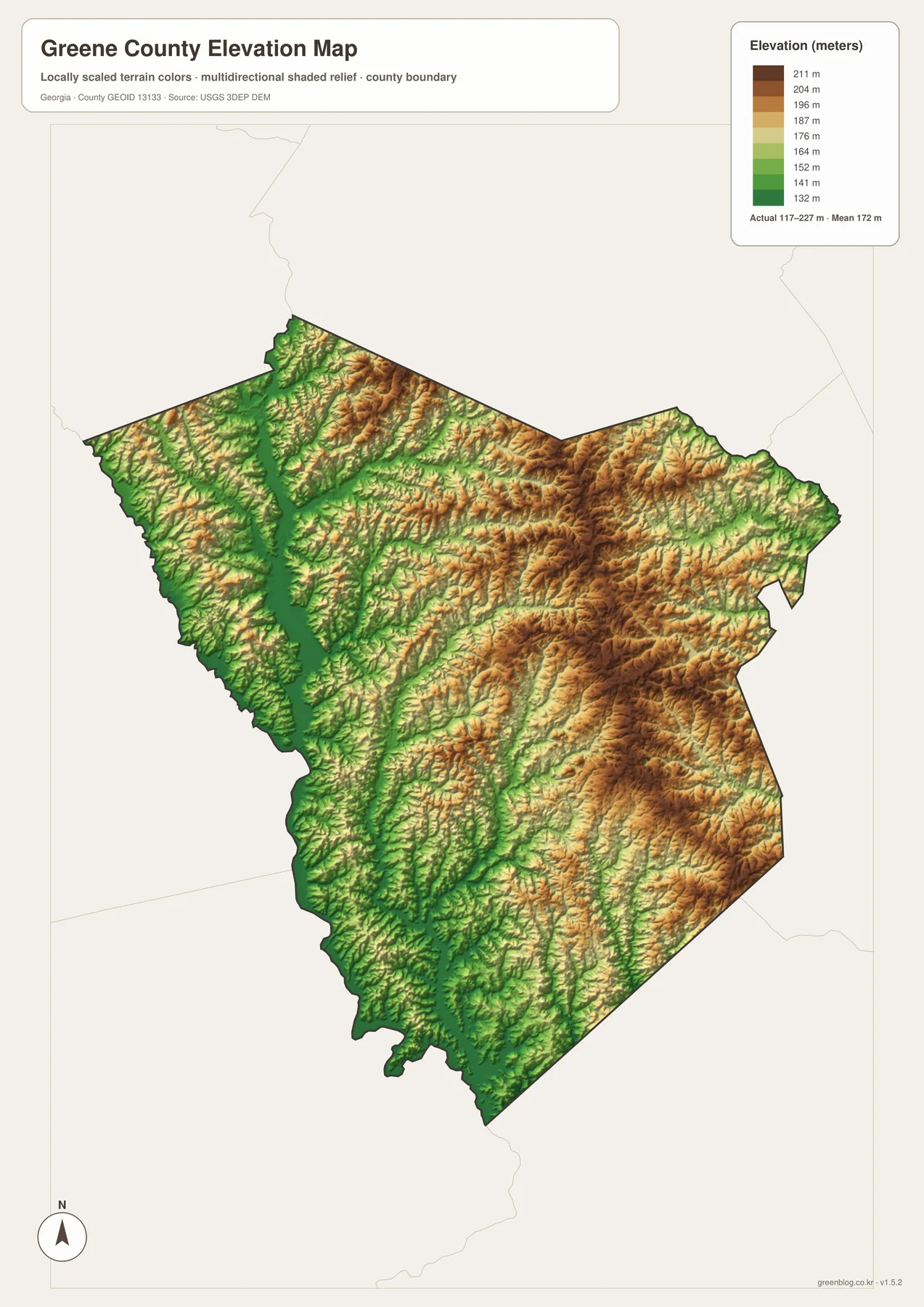
The supplied elevation view gives Greene County an actual range of roughly 117 to 227 meters, with a mean of 172 meters. The west contains the most continuous green lowlands, especially along the Oconee River and the reservoir-influenced southwest. Much of the eastern half rises into tan and brown rolling terrain. A difference of about 110 meters is modest compared with the mountains of northern Georgia, yet it is enough to create a strong visual separation between broad river valleys and the higher ground between them.
The Oconee corridor is the easiest place to compare water and relief. A long green band runs from the northwestern side toward the southwest, following the same route as the river on the water map. The widened shoreline in the lower county also sits in low terrain. Greensboro lies near the edge of this broader western lowland rather than in the highest part of the county. That setting helps explain why the road map and the water map both give the central-western area such a different appearance from the eastern municipal cluster.
East of Greensboro, the terrain becomes more strongly rolling. The Union Point, Siloam, and White Plains side contains broad tan and brown areas cut by narrow green stream valleys. The Little River and Ogeechee River forks occupy some of those lower corridors. The northeast is similarly textured, with repeated small ridges rather than one continuous plateau. This is useful context for the city distribution map because the eastern towns sit among a dense pattern of hills and tributaries that the simplified city view deliberately leaves out.
The relief colors are designed to compare broad county-wide elevation, not to provide a survey value for a house lot or construction project. Engineering, drainage design, and exact property elevation require finer data and, when necessary, field measurements. For geography lessons, reports, or local orientation, the 117–227 meter range is enough to show the major contrast: the Oconee side is lower, while much of the eastern half consists of higher rolling ground broken by creek valleys.
Greensboro, Lake Oconee, and the County’s Modern Geography
The source material in the package states that Greene County was established in 1786 and identifies Lake Oconee, the I-20 corridor, resort development, agriculture, and historic towns as parts of the county’s modern context. The four maps here do not attempt to measure resort land, agricultural acreage, or historic-district boundaries. Instead, they provide the geographic framework behind those subjects: Greensboro at the county’s road center, several smaller cities toward the east, the Oconee and reservoir landscape to the west and southwest, and rolling higher terrain across much of the interior and east.
That framework is especially visible around Greensboro. East-west routes connect the county seat with Union Point and Siloam, while Route 44 turns toward the southern water area. On the water map, the Oconee River occupies the low western corridor, and on the elevation map that same corridor remains green. The eastern city cluster occupies higher ground crossed by the Little River and Ogeechee River forks. The county therefore has two strong organizing ideas on the map: roads and municipalities around Greensboro, and a separate natural structure created by water and relief.
The general map is the most useful starting point when roads, towns, and county position all matter. The ranked city view is cleaner for comparing Greensboro, Union Point, Siloam, Woodville, and White Plains. The water map is the better reference for the Oconee River, reservoir shoreline, river forks, and named lakes, while the relief map explains how low valleys sit between higher rolling areas. The A3 JPG files in the ZIP retain those separate themes at a larger size, making them suitable for printing, classroom comparison, reports, and presentation slides.
Frequently Asked Questions
Which five cities are ranked on the city map?
The map ranks Greensboro, Union Point, Siloam, Woodville, and White Plains. Its displayed values are 3,609, 1,704, 344, 241, and 175 respectively; current official demographic figures should be checked separately through the Census source.
What water features stand out most clearly?
The Oconee River is the dominant western feature, with a broad reservoir shoreline extending through the southwest. The map also labels the North and South Fork Little River, the North and South Fork Ogeechee River, Town Creek, and several smaller lakes and ponds.
How much elevation difference is shown?
The relief map reports an actual range of about 117 to 227 meters and a mean of 172 meters. The Oconee River corridor is among the lowest areas, while much of the eastern half appears as higher rolling terrain.
What does the A3 download package contain?
The ZIP contains four large JPG originals covering the county reference map, five-city distribution, waterways, and elevation. Keeping the subjects in separate files makes the labels easier to read when the maps are printed or placed in a document.
Map File Information
Greene County A3 Map Files
- Included Files: 4 high-resolution A3 JPG map files shown in this article
- File Type: JPG files in a ZIP archive
- Intended Use: Printing, education, presentations, and map-based projects
Related Maps
Greene County Data and Reference Sources
- U.S. Census Bureau QuickFacts: Greene County – current county statistics
- New Georgia Encyclopedia: Greene County – county history and regional background
- Census TIGER/Line boundary resources – geometry for Greene County and neighboring county reference
- USGS hydrography resources – reference data for the Oconee River, tributaries, lakes, and other mapped waters
- USGS 3DEP elevation resources – source elevation data for comparing the 117–227 meter terrain range
Green Map creates custom-edited map images using open geographic data sources such as geoBoundaries, Natural Earth, OpenStreetMap, and government open data. These maps are edited visual materials, not raw data files, and are provided for education, documents, presentations, and graphic reference.