Effingham County sits in eastern Georgia near the Savannah metropolitan area, but its map is not defined by one city alone. Rincon, Springfield, and Guyton occupy different parts of the county, numbered highways connect them, and a dense network of creeks becomes more noticeable toward the lower eastern and southern ground. This page brings those features together in four map views, with a downloadable ZIP containing four high-resolution A3 JPG files for printing or offline reference.
The four views are useful because the county changes character depending on what you choose to emphasize. A road-and-place map makes Springfield and Rincon easy to locate, the city view compares the three main labeled communities, the water map strips away much of the road detail so the Ogeechee system stands out, and the elevation map shows why the stream corridors look different from the higher northwest. Reading them together gives a much clearer picture than a single general-purpose map.
Table of Contents
Effingham County at a Glance
Springfield is the county seat, while the city map treats Rincon as the primary hub and places Guyton to the west. The existing county material identifies 1777 as the year Effingham County was established. Its present-day setting near Savannah helps explain why the southern and southeastern part of the county is important for commuting and regional connections, even though the administrative center remains farther inland at Springfield.
The county itself is long from north to south and narrows toward its southern end. Its northern boundary is irregular, while the southeast edge bends around a low, water-rich landscape. That shape matters when reading the maps: places and highways are concentrated in a few corridors, but the creeks and elevation changes extend across the full county. A visitor looking only for city names can use the first two maps, while someone interested in the natural setting will get more from the water and elevation views.
Roads and Places on the County Map
The general county map places Springfield near the middle of the developed corridor, Rincon to the southeast, and Guyton to the west. Several numbered routes are visible, including 21, 119, 275, 95, 30, 17, 80, 26, and 16. The map does not need every local street to show the overall pattern: multiple routes converge around Springfield, while other roads continue south and southeast toward the edge of the Savannah area.
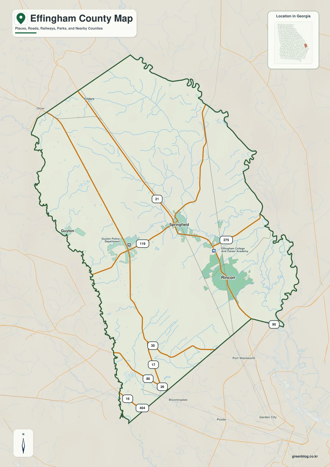
That makes this view especially useful for orientation. Springfield can be found quickly at the road junctions, Rincon is easy to pick out farther southeast, and Guyton gives a western reference point. The map also includes surrounding place labels outside the boundary, which helps a reader understand that Effingham County is part of a larger network rather than an isolated shape on the page.
This is still a county-scale reference, not a parcel or turn-by-turn street map. Small communities, every subdivision street, property lines, and site-specific boundaries are outside its purpose. For a classroom handout, county overview, travel planning at a broad scale, or a presentation that needs to show where the principal labeled places sit, the simpler level of detail is an advantage rather than a limitation.
Rincon, Springfield, and Guyton on the City Map
The city map changes the emphasis by making Rincon the hub and ranking Springfield second and Guyton third. Its information panel labels Rincon at 11,332, Springfield at 2,974, and Guyton at 2,740. It also gives direct-distance comparisons from Rincon: about 7 miles to Springfield and about 16 miles to Guyton. Those figures are presented as part of the map itself and are useful for comparing the relative scale and spacing of the three cities.
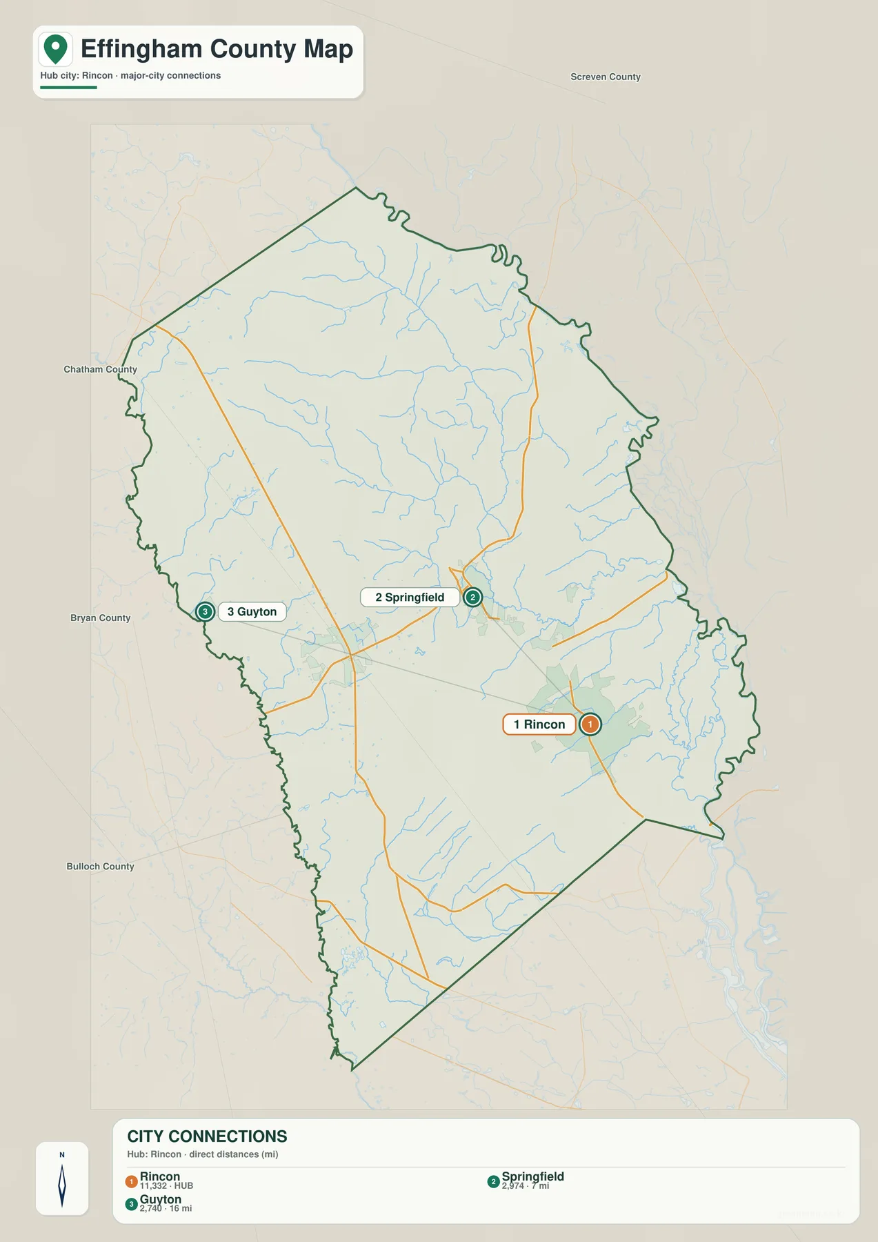
The difference between administrative importance and city size is easy to see here. Springfield is the county seat, yet Rincon is the larger hub on this map. Guyton sits well to the west of both, so the three places do not form a compact cluster. Instead, they create a broader east-west set of reference points across the developed part of the county.
Labels around the outside of the map include Screven, Chatham, Bryan, and Bulloch counties. They provide useful orientation when the county outline is viewed by itself. The southeastern position of Rincon also helps explain why discussions of Effingham County often connect it with the Savannah area: the county’s main population center lies closer to that side, while Springfield and Guyton sit farther inland.
Ogeechee River, Ebenezer Creek, and the Stream Network
The terrain-and-water map removes most of the urban emphasis and reveals how thoroughly Effingham County is crossed by water. Ogeechee River and Little Ogeechee River are labeled along the southwestern side. Farther inside the county, Ebenezer Creek is one of the most prominent named waterways, while Turkey Branch and Runs Branch occupy the central and northern portions. Smaller labels include Bony Creek, Raccoon Creek, Mill Creek, Sweigoffer Creek, and McCoys Cut toward the east and southeast.
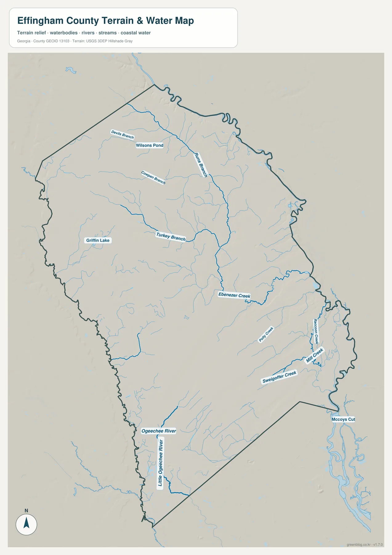
Willsons Pond and Griffin Lake add two still-water reference points in the northwestern half of the county. The eastern side has a noticeably tighter pattern of creeks, cuts, and branching channels. This does not mean every visible blue line is equally large; the value of the map is that it shows how many small drainage paths connect the landscape between the larger named waterways.
The water map should not be read as a flood-hazard or wetland-regulation map. It does not establish flood zones, property restrictions, boating access, or legal water boundaries. Its role is geographic: it lets a reader follow the major rivers and named creeks, see where minor streams become more concentrated, and compare those areas with the roads, cities, and elevation shown in the other views.
Elevation from the Higher Northwest to the Low Eastern Channels
The elevation map gives the county a very different appearance. Its legend reports an actual range of about -6 to 48 meters and a mean elevation of roughly 22 meters. These are modest elevations compared with mountainous Georgia counties, but the local contrast is still strong: brown and tan dominate much of the northwest, while green colors mark the lower eastern and southeastern ground.
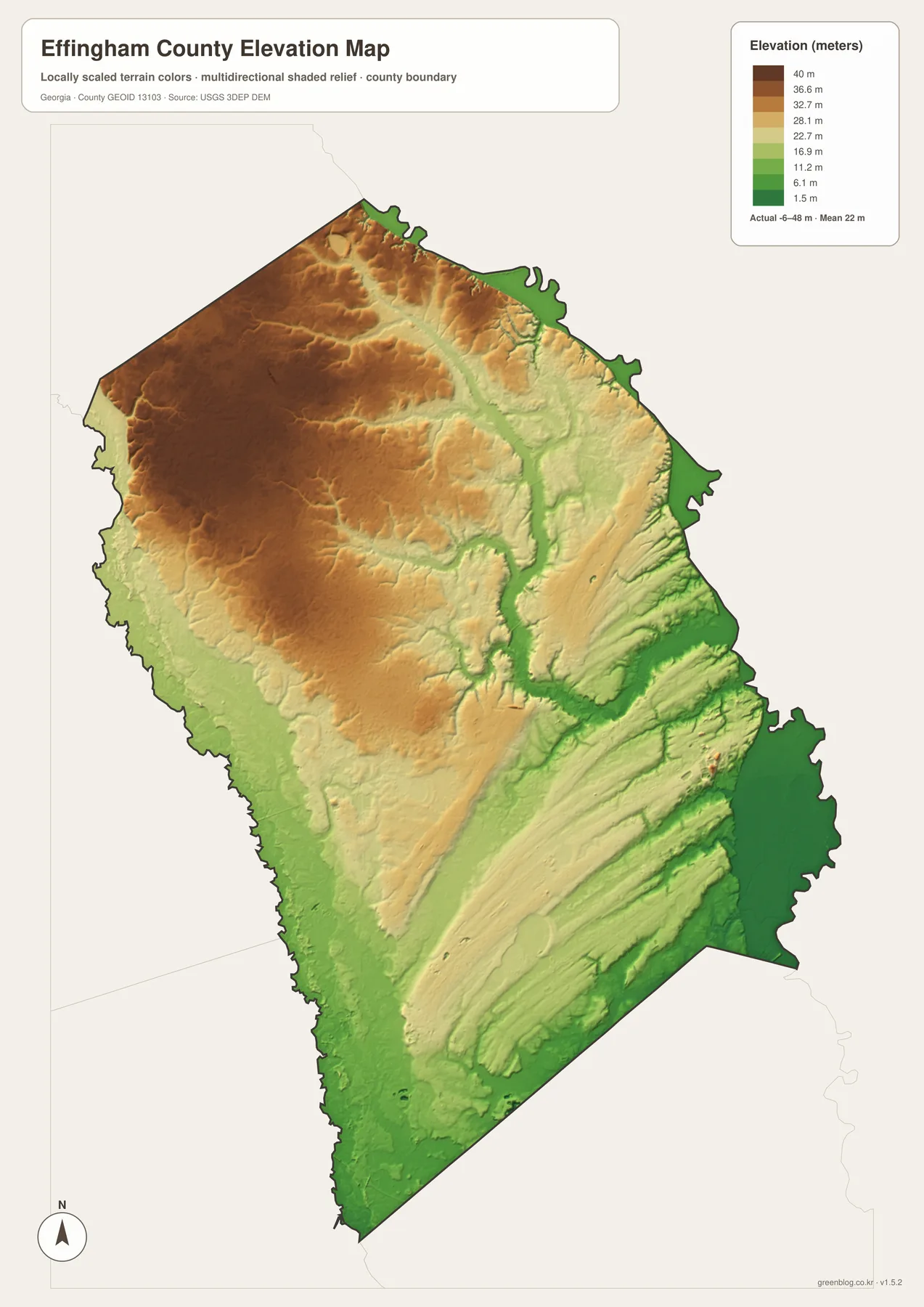
A broad higher surface covers much of the northwest, but narrow lower valleys cut through it. Moving east, those low corridors become more extensive and eventually connect with the deeply dissected creek country shown on the water map. The southeast corner is especially low, which matches the concentration of channels around that side of the county.
This comparison is useful because a general road map can make the county look almost flat. The shaded-relief view shows that even a low-elevation coastal-plain county has meaningful local relief. The difference is not a wall of mountains; it is a gradual shift from higher rolling ground in the northwest to lower river and creek corridors farther east and south.
What Becomes Clear When the Four Views Are Compared
The map set works best when each view answers a different part of the same geographic question. The county map establishes the boundary, principal places, and road network. The city map makes the spacing among Rincon, Springfield, and Guyton more explicit. The water map reveals a county threaded by creeks and rivers, while the elevation map explains why the east and southeast contain so many low channels.
For example, someone preparing a short presentation about Effingham County could start with the county map to locate Springfield and Rincon, switch to the city view to compare their positions, then use the water and elevation maps to explain the natural setting around them. A student focused on rivers might skip most of the road detail and rely on the water map, while a reader interested in terrain could use the elevation map to identify the higher northwest and lower Ogeechee-related corridors.
The downloadable files are designed for that flexibility. Each map is provided as its own A3 JPG rather than being flattened into one composite image, so the reader can print only the view needed for a lesson, report, local-history project, or personal reference. The WebP images on the page are convenient for browsing, while the ZIP preserves the larger JPG versions for offline use.
Frequently Asked Questions
Which city is the county seat of Effingham County?
Springfield is the county seat. The city map, however, identifies Rincon as the larger hub, so it is useful to distinguish the county’s administrative center from its largest labeled population center.
Which waterways stand out on the water map?
Ogeechee River and Little Ogeechee River are labeled on the southwestern side, while Ebenezer Creek is prominent farther east. The map also names several branches, creeks, ponds, and cuts, with particularly dense drainage in the eastern and southeastern portions of the county.
Is Effingham County completely flat?
No. The elevation map reports a range of about -6 to 48 meters with a mean near 22 meters. The northwest is generally higher, while stream and river corridors toward the east and southeast are lower.
Map File Information
Effingham County A3 map files
- Included Files: County, city, water, and elevation map views
- File Type: Four A3 JPG files in one ZIP archive
- Intended Use: Printing, education, presentations, and map-based projects
Related Maps
Sources and Further Reference
The links below provide county background and official data sources that can be used alongside the map set when a project needs more detail than a county-scale reference image can provide.
- U.S. Census Bureau QuickFacts – Effingham County, Georgia
- New Georgia Encyclopedia – Effingham County
- U.S. Census Bureau TIGER/Line Shapefiles
- USGS National Hydrography
- USGS 3D Elevation Program
Green Map creates custom-edited map images using open geographic data sources such as geoBoundaries, Natural Earth, OpenStreetMap, and government open data. These maps are edited visual materials, not raw data files, and are provided for education, documents, presentations, and graphic reference.