You can download the Banks County Map on this page as one ZIP containing four high-resolution A3 JPG files. The set separates the county into four useful views: roads and places, selected cities, streams and ponds, and elevation. That makes it easier to study northeast Georgia without forcing every label onto a single crowded image.
Banks County is organized around more than one center. Homer sits near the middle of the county and serves as the county seat, while I-85 and US 441 draw regional traffic toward the southeastern side. Several incorporated places also touch or cross county lines. The maps below are most useful when those relationships are compared rather than treated as one simple “county center” pattern.
Table of Contents
A quick orientation to Banks County
Banks County was created in 1858 from parts of Franklin and Habersham counties, and Homer is its county seat. The source material in the package lists a 2020 population of 18,035, a land area of 232.62 square miles, and a 2025 population estimate of 21,273. Those figures provide scale, but the map tells a more useful geographic story: the courthouse center, the interstate corridor, the border towns, and the stream-cut foothills occupy different parts of the county.
| State | Georgia |
|---|---|
| County seat | Homer |
| Created | 1858 |
| 2020 population | 18,035 |
| 2025 population estimate | 21,273 |
| Land area | 232.62 square miles |
| FIPS code | 13011 |
The existing county material identifies Habersham to the north, Stephens to the northeast, Franklin to the east, Madison to the southeast, Jackson to the south, and Hall to the west. That surrounding pattern matters because several place names extend beyond Banks County itself. Baldwin and Alto continue into Habersham County, Lula and Gillsville extend into Hall County, and Maysville continues into Jackson County. A town name in an address therefore does not, by itself, prove which county a property is in.
Roads, Homer, and the county framework
The general county map is the best starting point for orientation. Homer is labeled near the center, with Routes 51 and 164 nearby. US 441 runs through the southeastern half on its way toward Baldwin and Cornelia, while I-85 crosses the lower-right side of the county. Other numbered routes shown on the map include 15, 59, 63, 98, 105, 184, 198, 323, and 326, giving enough detail to see how local roads connect the interior with the larger highway network.
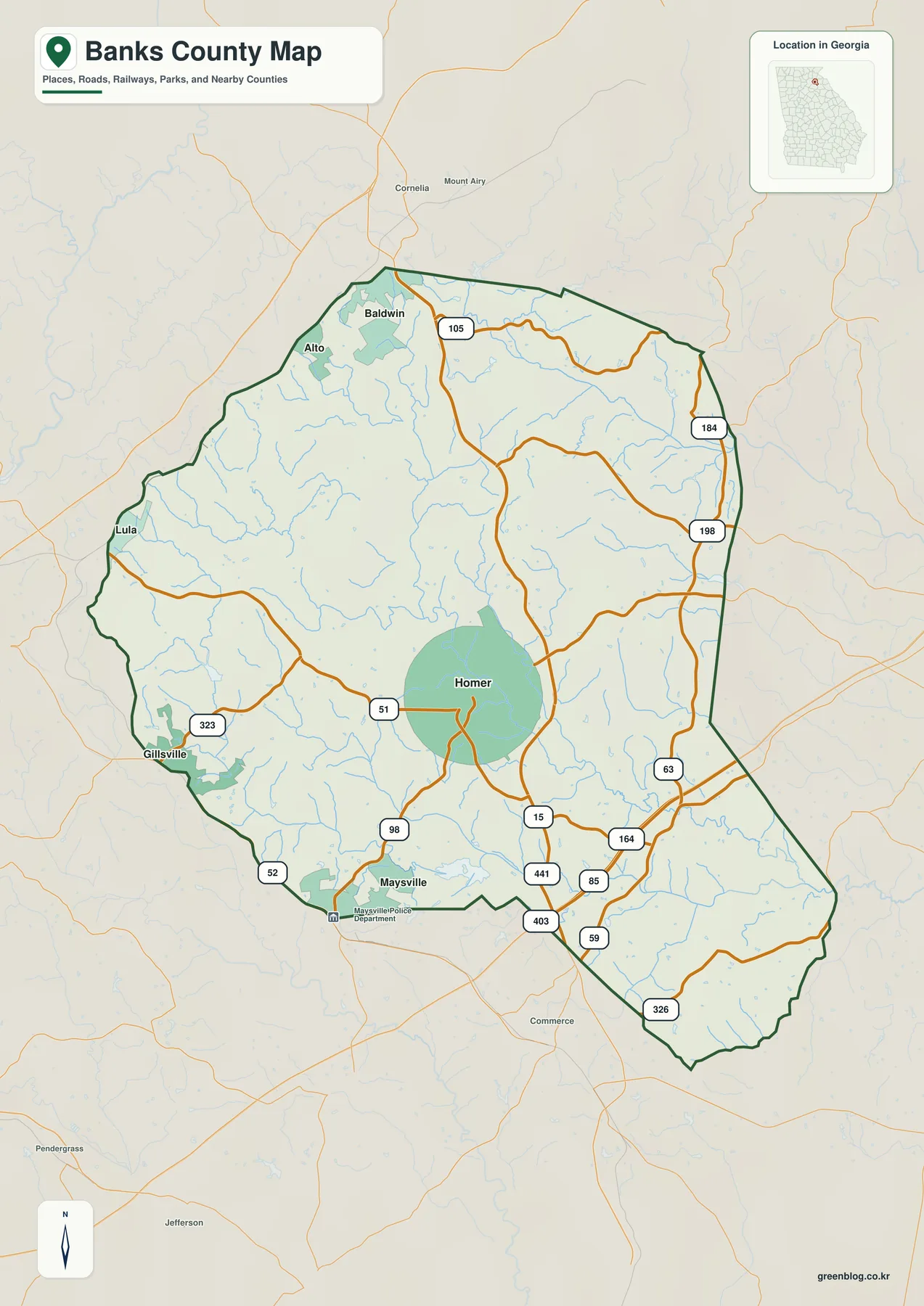
The highway pattern explains why Homer and the county’s busiest travel corridor are not the same place. The source package describes the I-85 and US 441 interchange at Exit 149 as the Banks Crossing area, where retail, lodging, services, and other highway-oriented activity concentrate. Homer remains the government center farther inland. Readers comparing public offices with regional travel or commercial access should keep those two locations separate.
The county map also gives context outside the boundary. Cornelia and Mount Airy appear north of Banks County, while Commerce, Jefferson, and Pendergrass are visible farther south and southwest. These labels are helpful for regional orientation, but the map is still a county-scale reference. It should not be used as a substitute for parcel boundaries, street-level navigation, or live road conditions.
Five mapped cities and a county seat in the middle
The city map reduces the visual noise from road shields and highlights five places: Baldwin, Maysville, Homer, Alto, and Gillsville. Homer appears near the center of the county. Baldwin and Alto sit close together along the northern edge, Gillsville is on the western side, and Maysville lies near the southern boundary. The arrangement makes it clear that several of the county’s named communities are peripheral rather than clustered around Homer.
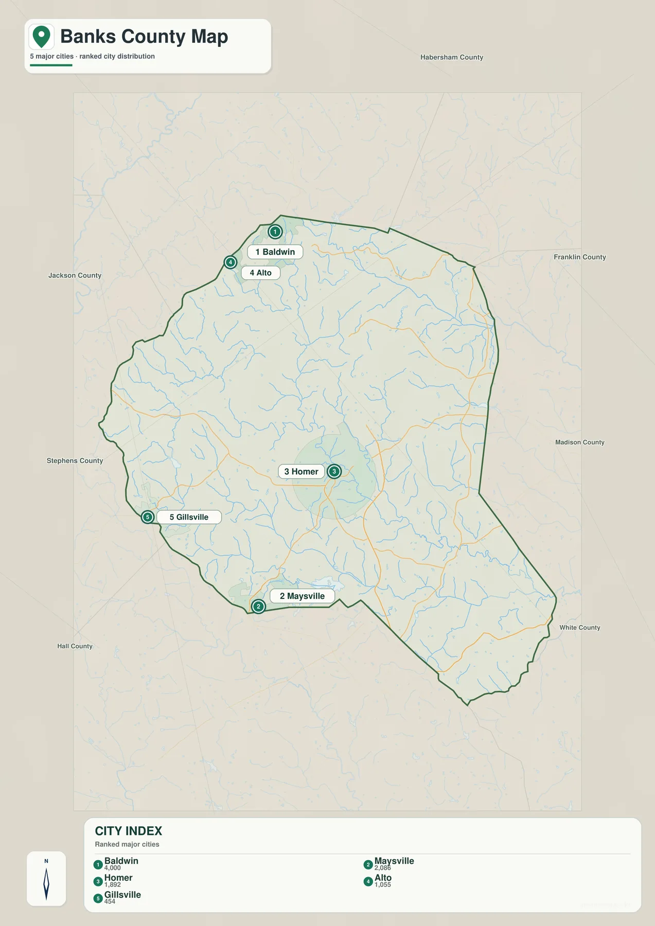
This view is especially useful for explaining cross-county municipalities. The package notes that Baldwin and Alto extend into Habersham County, Gillsville and Lula extend into Hall County, and Maysville extends into Jackson County. The city map does not replace municipal boundary data, but it shows why a county lookup may require more than matching a place name. When an exact address, school district, tax parcel, or service jurisdiction matters, an official GIS source should be checked.
Homer’s position also shows why “largest travel node” and “county seat” are different questions. The seat is centrally located for county government, while the interstate and US 441 corridor lies to the southeast. A classroom map, genealogy note, or local history page can use the city map to keep the administrative center visible without letting the highway corridor dominate the discussion.
Streams, tributaries, and small water bodies
Banks County’s water map is dense with streams rather than dominated by one large lake. The Middle Fork Broad River is labeled across the northern and northeastern area. Little Nails Creek, Silver Creek, Holbrook Creek, Hickory Level Creek, and Grove Creek cross the interior and western or southern portions, while the Hudson River is labeled near the southeastern side. Numerous smaller tributaries branch from these named channels.
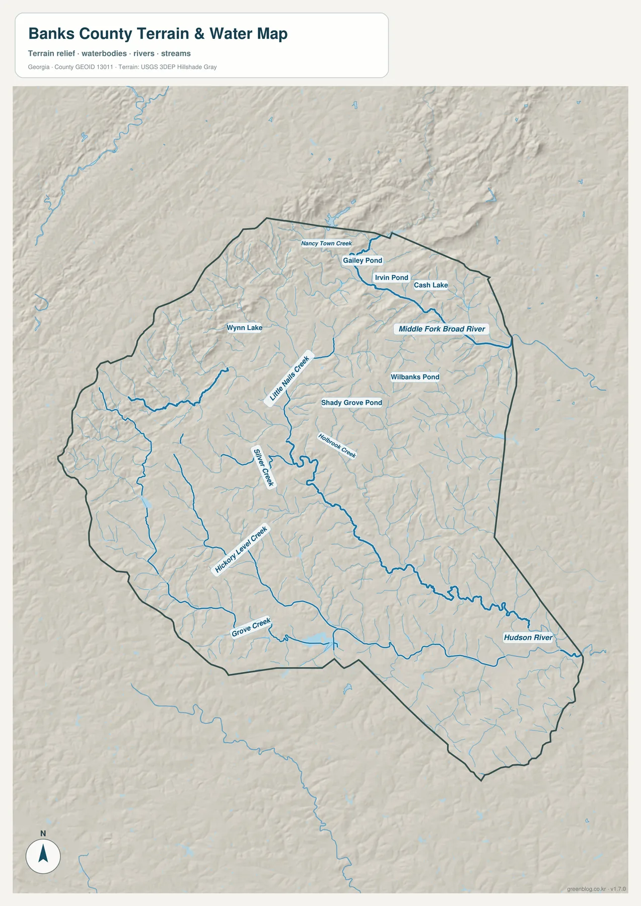
Several small water bodies are labeled as well, including Gailey Pond, Irvin Pond, Cash Lake, Wynn Lake, Wilbanks Pond, and Shady Grove Pond. None of them controls the county map the way a major reservoir would. Instead, they fit into a network of short valleys and stream branches. That is useful for readers who want to understand why the terrain appears dissected even though the county does not contain a single dominant mountain or lake feature.
The background material places many of these waters in the Broad-to-Savannah drainage, and Georgia’s water-planning material includes Banks County in the Savannah-Upper Ogeechee region. The package also notes a North Oconee tributary near Maysville on the southern side, showing that the county lies close to a drainage divide. For a general map page, the important point is that water leaves different parts of the county through different creek systems rather than following one central river from north to south.
Elevation from the higher northwest to the lower southeast
The elevation map adds a feature that the road and city maps cannot show: the county is made of rolling ridges and valleys. The map legend gives an actual elevation range of about 188 to 479 meters and a mean of about 265 meters. Darker high-elevation colors are concentrated most strongly along the western and northwestern side, while broader green areas mark lower ground toward the central and southeastern portions.
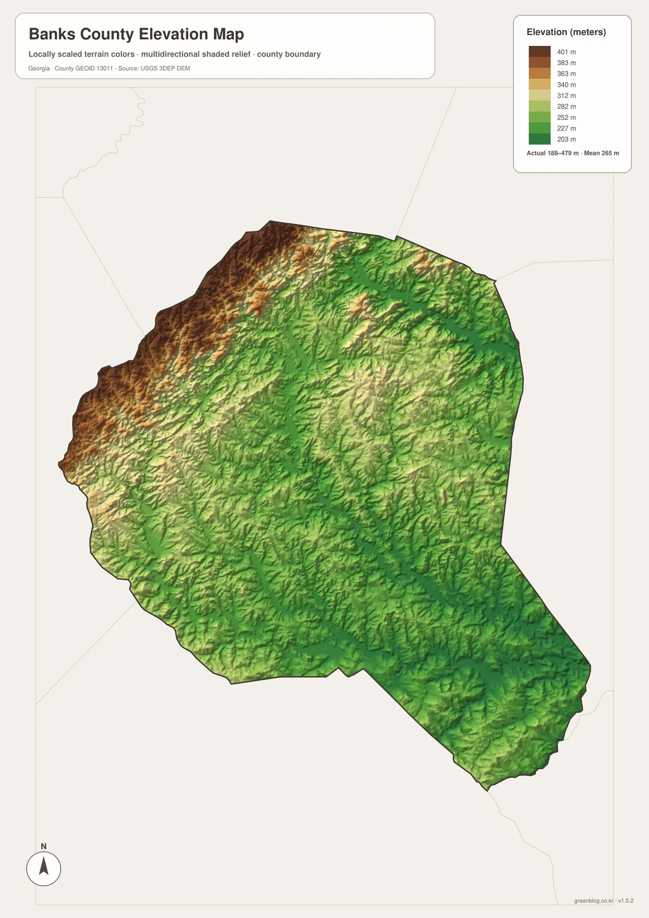
The shaded relief also reveals many short, narrow ridges rather than one continuous high crest. Those ridges are separated by stream valleys, which is why the elevation and water maps complement each other so well. Where the water map shows a branching creek, the relief map often shows the lower corridor that creek follows. The combination gives a clearer physical picture of Banks County than either layer provides alone.
This county-scale elevation image is meant for comparison, not engineering or property decisions. It is appropriate for explaining general relief, choosing a terrain illustration for a report, or comparing the northwest with the southeast. Precise slope, construction, survey, or parcel elevation work would require the original elevation dataset or an official survey product.
Which map should you use?
Use the county map when roads and regional orientation are the main topic. It keeps Homer, the boundary, US 441, I-85, and nearby place names in one frame. Choose the city map when the goal is to compare Baldwin, Maysville, Homer, Alto, and Gillsville without competing road labels. The water map is better for rivers, creeks, ponds, and drainage discussions, while the elevation map is the clearest choice for the county’s rolling topography.
The four files can also be paired. A transportation lesson can place the county and city maps side by side. A physical-geography page can compare the water and elevation maps to connect creek valleys with relief. Because the download contains large A3 JPGs, the images can be printed or resized for a presentation while preserving much more detail than the on-page previews.
- County map: roads, Homer, the county boundary, and nearby places
- City map: five highlighted cities and their relative positions
- Water map: named rivers, creeks, tributaries, ponds, and small lakes
- Elevation map: the roughly 188–479 m relief range and ridge-and-valley texture
Frequently Asked Questions
Where is the Banks County seat?
Homer is the county seat. It is shown near the middle of both the general county map and the city map, separate from the I-85 and US 441 highway area farther southeast.
What is included in the downloadable ZIP?
The ZIP contains four high-resolution A3 JPG files: a county map, city map, water map, and elevation map. The images shown in the article are WebP previews intended for quick viewing in the browser.
Do all labeled towns lie entirely inside Banks County?
No. The source material notes that several municipalities continue across county boundaries, including Baldwin, Alto, Gillsville, Lula, and Maysville. Use official GIS or address records when the exact county side of a municipal area matters.
Map File Information
Download the four Banks County map files
- Included Files: 4 high-resolution A3 JPG map files shown in this article
- File Type: JPG files in a ZIP archive
- Intended Use: Printing, education, presentations, and map-based projects
Related Maps
Sources and reference material
- U.S. Census Bureau QuickFacts – Banks County population and area
- New Georgia Encyclopedia – Banks County history and local context
- Banks County government – I-85, US 441, and Banks Crossing
- Georgia Water Planning – Savannah-Upper Ogeechee region
- USGS Water Data – monitoring locations in Banks County
Green Map creates custom-edited map images using open geographic data sources such as geoBoundaries, Natural Earth, OpenStreetMap, and government open data. These maps are edited visual materials, not raw data files, and are provided for education, documents, presentations, and graphic reference.