The Randolph County Alabama Map becomes much easier to understand when Lake Wedowee, the Georgia state line, Roanoke, Wedowee, and the county’s rolling Piedmont terrain are viewed together. This page separates those features into a general county-and-roads map, a city-connections map centered on Roanoke, a detailed terrain-and-water map, and an elevation map. After reviewing the maps on the page, you can download a ZIP containing four original A3 high-resolution JPG files for printing, teaching, local comparison, or personal map projects.
Randolph County does not revolve around a single place. Wedowee is the county seat near the middle of the county, while Roanoke is the largest city and a stronger population center in the south. Wadley lies to the southwest, Woodland to the northeast, and smaller places such as Graham and Rock Mills help define the eastern side near Georgia. The water network cuts through the interior, and elevation changes create ridges and valleys that affect the shape of roads and streams. Looking at those layers separately makes the county’s geography far clearer than a list of place names alone.
Table of Contents
An east Alabama border county with several local centers
Randolph County sits on Alabama’s eastern edge, where its county boundary also becomes the state line with Georgia. The supplied county material identifies Carroll, Heard, and Troup counties on the Georgia side, while Cleburne, Clay, Tallapoosa, and Chambers counties surround Randolph County within Alabama. That location matters because the eastern boundary is not merely a line between neighboring counties; it marks a state transition that helps explain why communities on the east side look toward a different set of nearby places than those on the west or south.
| State | Alabama |
|---|---|
| County | Randolph County |
| County seat | Wedowee |
| Largest city | Roanoke |
| Founded | December 18, 1832 |
| Area reference | About 585 sq mi in county material; about 580.6 sq mi of land in Census geography |
| Key highways shown | U.S. 431; Alabama 22, 48, 77 and other routes |
| Major water context | Tallapoosa River, Little Tallapoosa River, Lake Wedowee |
The county government’s information gives Randolph County an area of about 585 square miles and a founding date of December 18, 1832. Census geography reports about 580.6 square miles of land area. The difference is a reminder that total area and land area are not always the same measurement. For map reading, however, the more useful references are the Georgia boundary, Wedowee’s central position, Roanoke’s southern location, and the branching water system associated with Lake Wedowee.
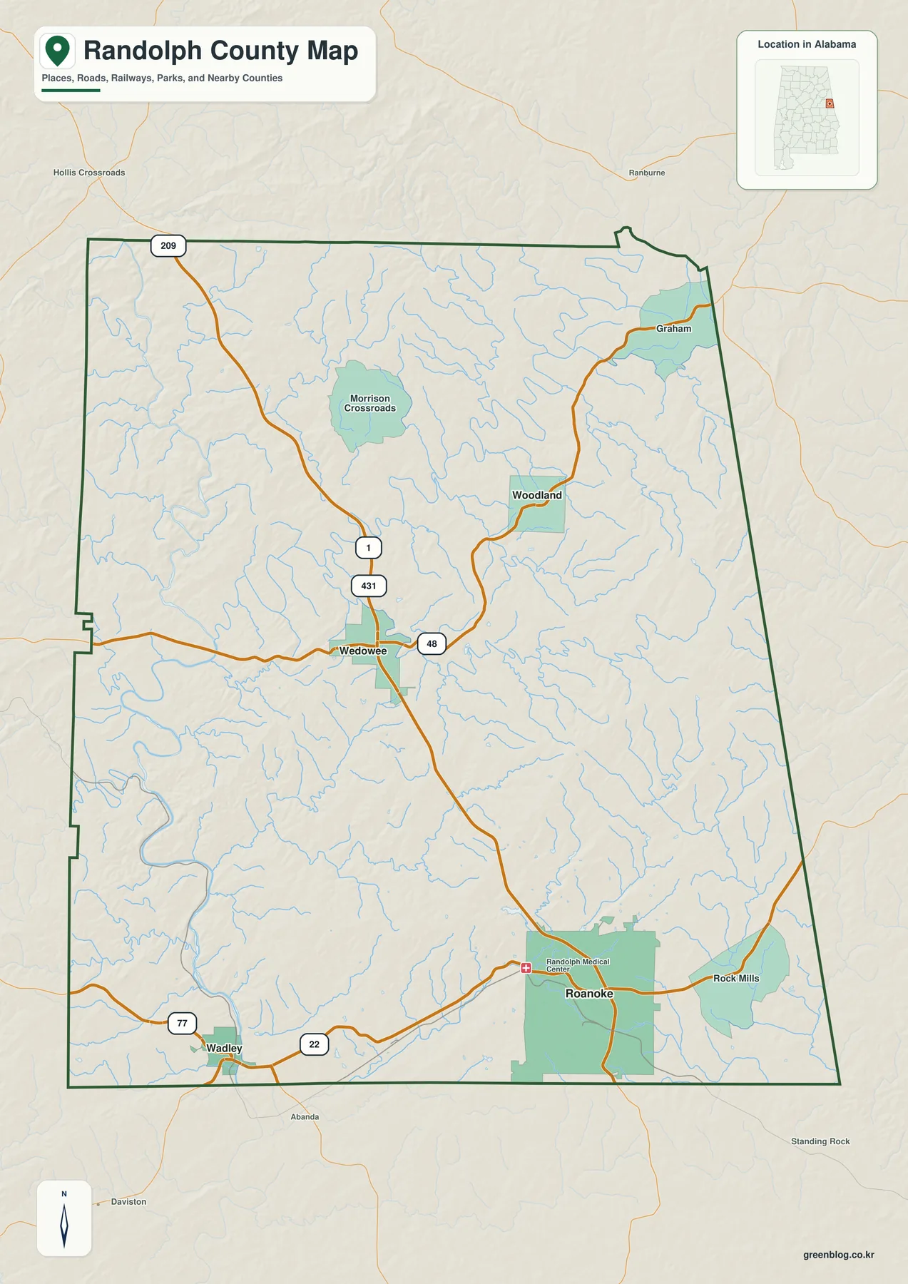
U.S. 431 is the clearest road for orienting the county. It enters from the north, runs through Wedowee, and continues south toward the Roanoke area. Alabama 48 adds an east-west connection around Wedowee, while Alabama 22 and 77 are important on the southern side near Roanoke and Wadley. Route 209 is also shown in the northwestern part of the map. The network is not a uniform street grid; longer highways connect separated communities across rolling terrain and numerous stream valleys.
The settlement pattern reinforces that point. Wedowee sits near the middle and works well as an administrative and geographic reference, but Roanoke appears as the larger urban area farther south. Wadley anchors the southwest, Woodland the northeast, and Graham and Rock Mills sit close to the Georgia side. Reading those locations together shows a county with several local centers rather than one dominant city surrounded by evenly spaced suburbs.
Roanoke connects to Wedowee, Wadley, and Woodland across different parts of the county
The city-connections map uses Roanoke as the hub and compares it with three other selected communities. Its index prints Roanoke at 5,336, Wedowee at 899, Wadley at 753, and Woodland at 682. The connector labels show approximately 13 miles from Roanoke to Wedowee, 12 miles to Wadley, and 16 miles to Woodland. These are straight-line distances, not driving distances, so they are most useful for understanding relative position and direction rather than estimating a road trip.
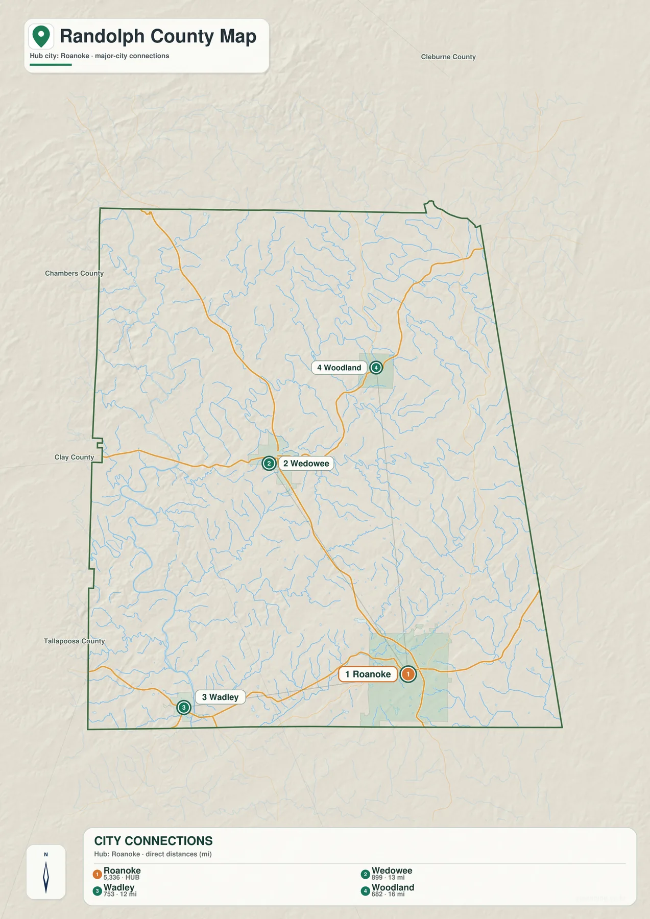
The map makes the difference between administrative importance and settlement size especially clear. Wedowee is the county seat, yet Roanoke is used as the city hub because it is the larger population center in the supplied material. Wadley and Woodland sit in opposite directions, giving the county a distinctly dispersed layout. A straight connector can make these places look simple to reach, but the actual road route may be longer because highways bend around ridges, stream valleys, and the branching Lake Wedowee system.
Census geography provides another way to think about the same multi-center pattern. The existing source material divides Randolph County into five county subdivisions, or CCDs: Folsom, Roanoke, Wadley, Wedowee, and Woodland. CCDs are statistical areas rather than municipal governments, but the names help show how population data are organized across different parts of the county. The overlap between those names and the places visible on the map reinforces the idea that Randolph County is made up of several recognizable local areas.
Lake Wedowee sits within a branching Tallapoosa River system
Water is one of the strongest physical features in Randolph County. The supplied background explains that the upper Tallapoosa River and Little Tallapoosa River meet in R. L. Harris Reservoir, commonly known as Lake Wedowee, before the system continues downstream as the Tallapoosa River. Because the lake is a reservoir occupying flooded river valleys, it does not form one compact round basin. Long arms reach into the surrounding countryside, and those branches affect how roads and nearby communities relate to one another.
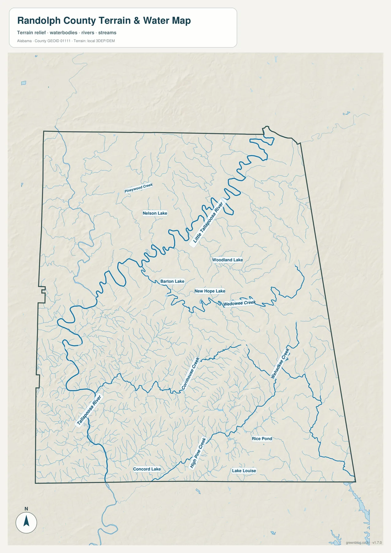
Little Tallapoosa River is the most prominent labeled river in the upper and central part of the water map, winding from the northeast toward the west. Tallapoosa River is labeled farther southwest. Wedowee Creek enters the central-eastern part of the system, while Pineywood Creek appears in the northwestern interior. Named water bodies such as Nelson Lake, Woodland Lake, Barton Lake, New Hope Lake, Concord Lake, Rice Pond, and Lake Louise provide additional local reference points that are difficult to see on the more general road map.
The branching water network is important for practical orientation. Two locations can be close as the crow flies but separated by a long reservoir arm or stream valley, forcing a road route toward a bridge or a better crossing. That is one reason the straight-line city connectors should not be treated as driving distances. Comparing the water map with the road map shows where the geography becomes more complicated around Wedowee and the central part of the county.
This water map is a geographic reference, not a flood-risk, parcel-boundary, navigation, or engineering product. It is useful for identifying rivers, streams, reservoirs, and named small lakes; for classroom work; and for explaining how water divides the county landscape. Current flood zones, legal water boundaries, boating conditions, and site-specific drainage require specialized sources.
Elevation ranges from 183 to 464 meters across a strongly dissected Piedmont landscape
The elevation map makes Randolph County’s rolling and rugged character immediately visible. Its printed summary gives an actual elevation range of 183 to 464 meters, with a mean of 287 meters. Lower green terrain follows many valleys and parts of the west and southwest, while higher tan and brown ridges become especially noticeable in the north and east. The relief is not concentrated into one mountain block; ridges and valleys repeat across much of the county.
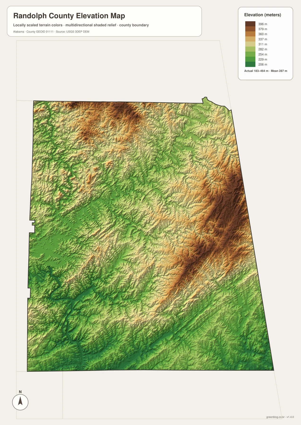
The existing regional description places Randolph County in Alabama’s Piedmont, a landscape of rolling uplands and stream valleys rather than broad flat coastal plain. The elevation surface matches that description. Between Roanoke, Wedowee, Woodland, and the Georgia line, ridges and valleys appear repeatedly, which helps explain why both roads and streams follow irregular paths. The physical terrain is therefore not just background decoration; it is part of the reason the county’s communities and transport routes are spread the way they are.
The elevation and water maps work particularly well together. Little Tallapoosa River, Wedowee Creek, and other tributaries occupy lower valley floors, while the brighter and browner terrain marks higher ground between them. Lake Wedowee follows the same broad valley system because the reservoir fills branching river channels. This relationship is useful for general geographic understanding, but the elevation map is a county-scale reference and should not be used as survey-grade height information for a parcel, construction project, drainage design, or engineering calculation.
U.S. 431 provides the simplest road reference from Wedowee toward Roanoke
For road orientation, U.S. 431 is the best place to start. It passes through Wedowee and continues south through the county toward the Roanoke side, while also connecting north toward Cleburne County. This route gives the central and southern parts of Randolph County a clear north-south framework. Alabama 48 serves the Wedowee area, and Alabama 22 and 77 help define the southern network around Roanoke and Wadley.
Wadley lies southwest of the county seat, Woodland is northeast, and Graham and Rock Mills provide useful eastern references close to Georgia. These directions matter because the county’s travel pattern is not simply a series of short trips radiating from Wedowee. Some communities are better connected to Roanoke, others sit closer to the state line, and water or ridge crossings can lengthen the practical route between two points.
The city map’s 13-mile Roanoke-Wedowee connector is a good example. It accurately communicates the relative separation of the two centers on a map, but it is not intended to replace turn-by-turn directions. A driver must follow the road network through rolling terrain and around water features. When the goal is actual travel, use a current navigation source; when the goal is geographic comparison, the county and city maps provide a much cleaner picture.
Choose the map by the question you want to answer
Use the general county map for boundaries, community names, highways, smaller roads, streams, and nearby places in one view. It is the best starting point for locating Wedowee, Roanoke, Wadley, Woodland, Graham, and Rock Mills while keeping U.S. 431 and the Georgia side in context. The city-connections map is better when the question is how Roanoke relates to Wedowee, Wadley, and Woodland by direction and straight-line distance.
Choose the water map when Lake Wedowee, Little Tallapoosa River, Tallapoosa River, Wedowee Creek, or smaller named waters are the focus. It removes much of the road emphasis and makes tributaries and lakes easier to identify. Use the elevation map when terrain matters more than labels. The 183-464 m range and the strong pattern of ridges and valleys show why this part of eastern Alabama looks and travels differently from flatter counties.
For a classroom handout, local-history project, printed reference, or personal map design, the four maps complement one another. The general map establishes place and transport, the city map simplifies settlement relationships, the water map explains the reservoir and tributary network, and the elevation map supplies the physical relief beneath those features. The downloadable ZIP below contains all four original A3 high-resolution JPG files rather than only the smaller WebP previews shown on the page.
Frequently Asked Questions
Are the county seat and largest city the same place?
No. Wedowee is the county seat, while the supplied county material identifies Roanoke as the largest city. The general map places Wedowee near the middle of the county and Roanoke farther south, making the difference between administrative center and larger settlement easy to see.
Are the 12-16 mile labels on the city map driving distances?
No. The map shows straight-line connections from Roanoke: about 13 miles to Wedowee, 12 miles to Wadley, and 16 miles to Woodland. Actual driving distance can be longer because roads follow ridges, cross streams at limited points, and may need to route around branches of the reservoir.
How is Lake Wedowee related to the Tallapoosa River system?
The supplied background explains that the upper Tallapoosa River and Little Tallapoosa River meet in R. L. Harris Reservoir, commonly called Lake Wedowee, before continuing downstream as the Tallapoosa River. The water map helps show the branching river valleys and tributaries that feed the reservoir system.
Map File Information
Randolph County map files
- Included Versions: county, city connections, water, elevation
Related Maps
- Abbeville, Headland, and Lake Eufaula on the Henry County Alabama Map
- Athens to Wheeler Reservoir on the Limestone County Alabama Map
- Autauga County Map
Sources and references
- Randolph County Alabama official website — county seat, communities, founding date, and local background
- U.S. Census Bureau — land area, CCDs, and census geography
- Outdoor Alabama: Tallapoosa River — Tallapoosa River, Little Tallapoosa River, and reservoir drainage context
- Alabama Power: Harris Lake — R. L. Harris Reservoir and Lake Wedowee background
- USGS 3D Elevation Program — elevation-data reference
Green Map creates custom-edited map images using open geographic data sources such as geoBoundaries, Natural Earth, OpenStreetMap, and government open data. These maps are edited visual materials, not raw data files, and are provided for education, documents, presentations, and graphic reference.