Download the Madison County Alabama Map as four A3 high-resolution JPG files in one ZIP, while using the WebP images on this page as quick previews. The maps cover the county reference view, major cities, waterways, and elevation, so you can compare Huntsville and Madison with the Tennessee River system and the higher ground to the east. That comparison is especially useful here because the broad, low Tennessee Valley changes quickly into steeper ridge-and-valley terrain on the eastern and southeastern side of the county.
Huntsville is the easiest place to begin. Madison lies immediately to the west, Redstone Arsenal occupies a large area to the southwest, and communities such as Harvest, Hazel Green, Meridianville, Moores Mill, and New Market spread across the northern valley. Gurley is near the eastern side, while Owens Cross Roads and New Hope sit farther south where the mountains crowd closer to the developed area. Wheeler Reservoir follows the southern edge, and the Flint River and other tributaries carry water through the county toward the Tennessee River system. Looking at these features together makes the map more useful than a simple list of place names.
Table of Contents
Huntsville, County Boundaries, and the Main Road Corridors
Madison County is in northern Alabama and reaches the Tennessee state line. Limestone County borders it on the west and Jackson County on the east. Along much of the south, the Tennessee River creates a broad natural edge with Morgan County beyond the river, while the southeastern side approaches the higher country toward Marshall County. This location places most of the county within the Tennessee Valley, but the landscape is not uniformly flat. The central, western, and northern areas are generally open and low, whereas long ridges rise sharply near the eastern boundary and immediately east of Huntsville.
The reference map shows that contrast through both settlement and transportation. Huntsville is the county seat and largest urban center. Madison forms a closely connected developed area to the west, while Redstone Arsenal occupies a broad federal tract southwest of central Huntsville. Farther north are Harvest, Hazel Green, Meridianville, Moores Mill, and New Market. Gurley appears near the eastern edge, and the southern communities of Owens Cross Roads and New Hope sit closer to the ridge-and-valley landscape. Their positions help explain why development looks expansive on the west side but more constrained in the east and southeast.
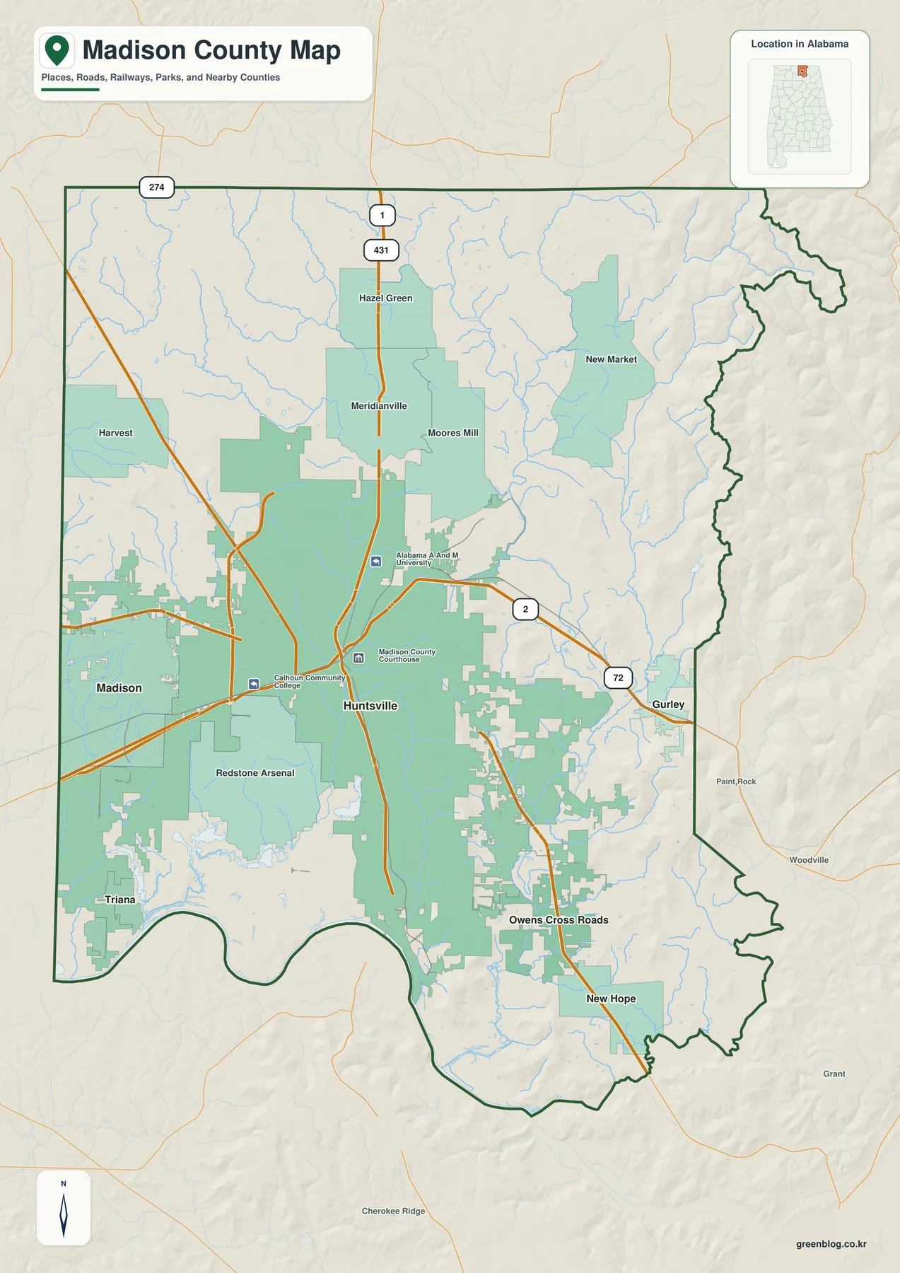
Several routes organize the county. U.S. 231/431 runs north from Huntsville through the Meridianville and Hazel Green area toward Tennessee. U.S. 72 crosses the developed Huntsville-Madison area and continues east toward Gurley and Jackson County. I-565 provides the major western approach to Madison and Huntsville and serves access points around Redstone Arsenal, while Alabama 53 reaches the northwestern side near Harvest. Alabama 255 is another important corridor on the western side of Huntsville. On the lower valley floor these roads can follow long, relatively direct paths; to the east, ridges and narrow valleys force travel into fewer usable corridors.
Redstone Arsenal is also important when interpreting the road pattern. It is not an ordinary city neighborhood but a large federal installation, so the southwest side of Huntsville does not display a continuous public street grid. The reference map therefore works well for more than locating the county line. It helps explain why the Huntsville-Madison urban area spreads broadly to the west and north, while movement toward Gurley, New Hope, and Owens Cross Roads is more strongly shaped by terrain.
Six Major Cities from Madison and Triana to Gurley
The city map reduces the number of labels and highlights six places: Huntsville, Madison, Triana, New Hope, Owens Cross Roads, and Gurley. Huntsville occupies the central urban position, Madison is to the west, and Triana sits southwest near the Tennessee River and Wheeler Reservoir. New Hope and Owens Cross Roads are on the southern and southeastern side, while Gurley marks the eastern part of the county. This stripped-down view makes it easy to compare directions without the additional community, road, and stream labels that appear on the reference map.
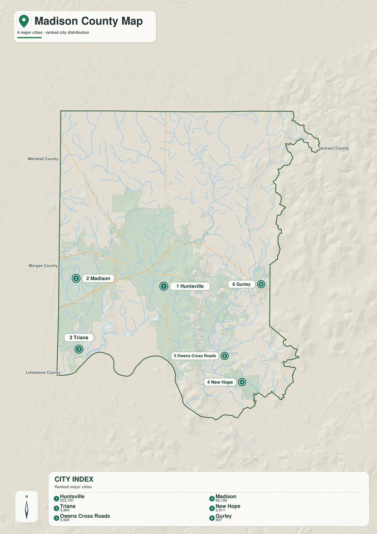
The population labels on this particular city map also show a large difference in scale. Huntsville is marked at 222,791 and Madison at 60,106. Triana is labeled 3,964, New Hope 2,911, Owens Cross Roads 2,826, and Gurley 607. Those figures are useful for comparing the six selected places, but they should not be treated as a complete description of settlement across the county. Harvest, Hazel Green, Meridianville, Moores Mill, and New Market are all important parts of the broader northern and northeastern pattern even though they are not among the six ranked cities.
Terrain and transportation help explain the pattern. I-565 and U.S. 72 support a broad east-west urban corridor through Huntsville and Madison, while U.S. 231/431 and Alabama 53 extend into relatively open country north of the city. Around Owens Cross Roads and New Hope, the ridges are much closer together. The straight-line distance to Huntsville may be modest, but roads still have to use lower gaps and valleys, so development follows a more confined shape. Comparing the city and elevation maps is the clearest way to see why two parts of the same metropolitan area can look so different.
Triana and Gurley provide another useful contrast. Triana is close to Wheeler Reservoir on the low southwestern side of the county, while Gurley sits near the eastern mountain front. Their settings are visible even before reading any population data. One lies beside the broad river-and-valley landscape; the other occupies a narrower passage near higher ridges. The city map is most useful when those geographic settings are kept in mind rather than reading the six labels as isolated dots.
Wheeler Reservoir, Flint River, and the Tributary Network
The Tennessee River and Wheeler Reservoir dominate Madison County’s southern edge. The reservoir widens below Triana and the Redstone Arsenal area, creating a clear geographic reference that is easy to recognize on both the county and water maps. The dedicated water map then adds a much denser network of tributaries. Small streams spread across the northern and central county before joining larger channels that ultimately connect with the Tennessee River system. This makes the water view useful for understanding the county as a drainage landscape rather than just locating one large river.
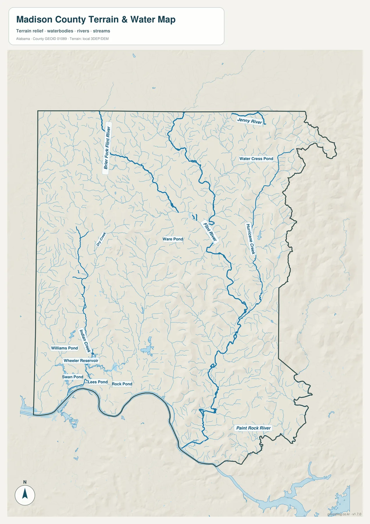
Flint River is one of the strongest internal features on the map, running south as numerous smaller streams join it. Brier Fork Flint River is labeled in the northwestern drainage area, Hurricane Creek stands out farther east, and Paint Rock River appears near the southeastern edge. Indian Creek is visible on the western side. The map also labels smaller water bodies near Wheeler Reservoir, including Williams Pond, Swan Pond, Lees Pond, and Rock Pond. Instead of treating these as a list to memorize, it is more useful to follow the larger channels first and then see how the smaller tributaries feed into them.
The southeast is where water and terrain are easiest to connect. Around New Hope and Owens Cross Roads, streams occupy lower valleys between ridges, and roads and developed areas tend to use many of the same passages. In the north and northwest, drainage crosses a broader and gentler valley floor, leaving more room for roads and neighborhoods to spread in several directions. The water map is a reference for river, creek, pond, and drainage locations; it is not a flood-risk map, navigation chart, parcel map, or legal water-boundary product.
This connection is helpful when reading the Huntsville area as well. The Tennessee River forms a major southern limit, while the Flint River and many smaller channels divide the interior into a series of local valleys. Roads sometimes bend with those valleys or cross the streams at a limited number of points. Moving back and forth between the reference map and the water map reveals relationships that are easy to miss if each subject is viewed separately.
From the Low Tennessee Valley to the Eastern Ridges
The elevation map shows the strongest physical contrast in Madison County. Its legend reports an actual range of about 168 to 566 meters, with a mean elevation of 239 meters. Lower green tones cover much of the west, north, and the area near the Tennessee River. Higher colors become increasingly prominent along the eastern boundary, in the northeast, east of Huntsville, and across ridges that extend toward the southeastern corner. The result is not a gentle countywide slope but a sharp transition between broad valley floor and narrow high ground.
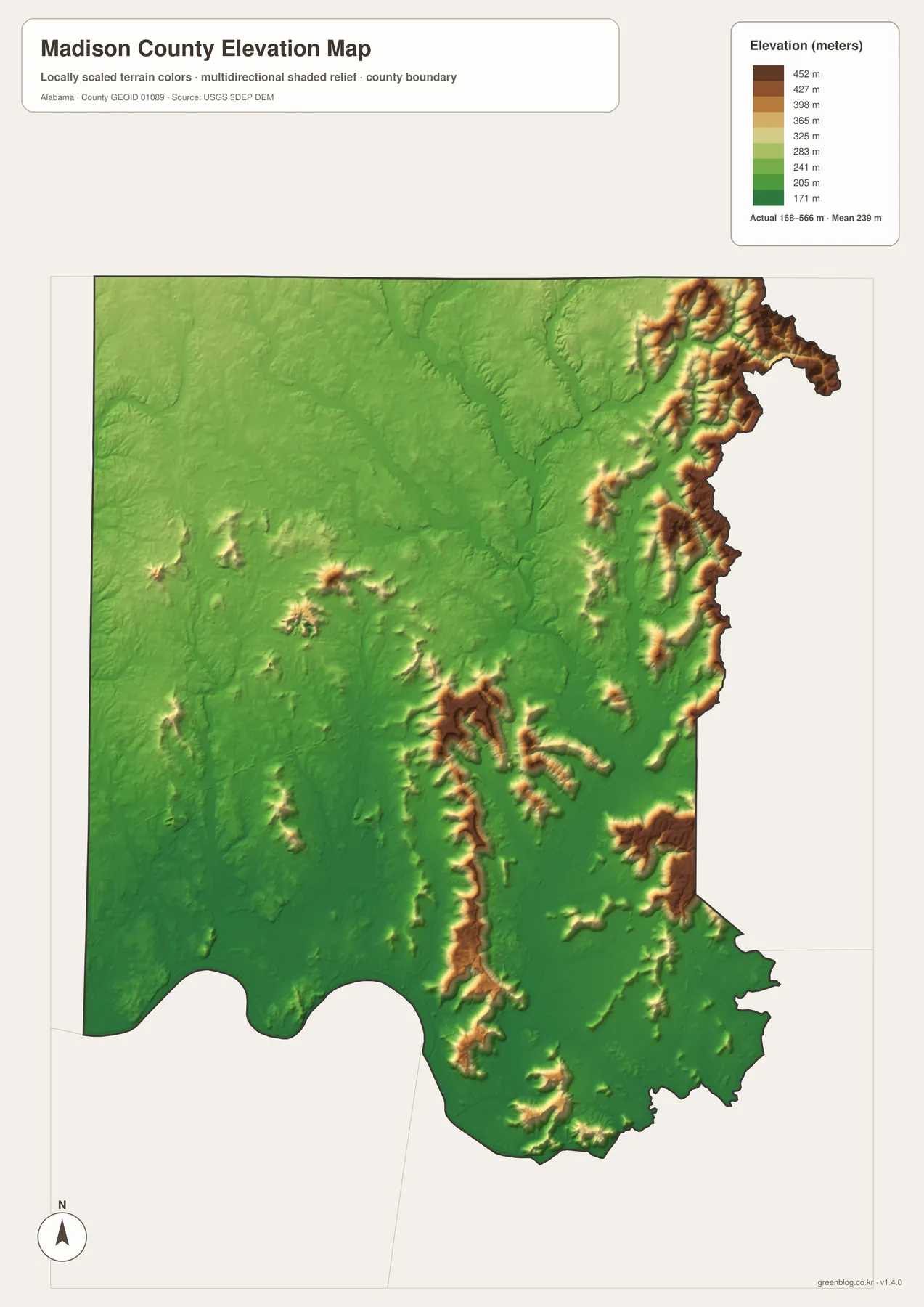
Monte Sano and Green Mountain are useful named examples of the higher terrain close to Huntsville. They stand immediately east and southeast of the main urban area, creating real barriers to direct travel even though they are close in straight-line distance. Routes toward Hampton Cove and Owens Cross Roads must use lower gaps and valleys instead of spreading across the landscape in the same way as roads west of Huntsville. This is one reason the eastern road pattern looks more confined than the wide suburban network around Madison.
North of Huntsville, the situation is different. Hazel Green, Harvest, Meridianville, and nearby communities occupy a much broader lowland with fewer major topographic obstacles. U.S. 231/431 and Alabama 53 can continue north for long distances, and development has room to spread outward from the road corridors. When the city map is placed beside the elevation map, the geography becomes much clearer: the west and north are defined by open valley terrain, while the east and southeast are shaped by ridges and the lower passages between them.
The elevation colors are intended for regional comparison, not engineering measurement. They make it easy to identify high ridges, low valleys, and the overall relief pattern, but they should not be used to determine the exact elevation of a building site or to make construction, drainage, or survey decisions. For work that depends on precise elevation values, an authoritative source such as the USGS 3D Elevation Program should be consulted directly.
Redstone Arsenal, Transportation, and the Growth of Huntsville
Modern Madison County is easier to understand when the transportation history is considered alongside the current road map. The county was created in 1808 during the Mississippi Territory period and named for James Madison. Huntsville grew around Hunt’s Spring and became an early regional center. The county’s official history records the completion of the Memphis and Charleston Railroad in 1855, while the Tennessee River also connected the area with a wider transportation network. Those older river and rail links existed long before I-565 and today’s suburban road system.
The southwest side changed substantially beginning in 1941 with Huntsville Arsenal and Redstone Ordnance Plant. After World War II, Redstone Arsenal became closely associated with Army rocket and missile work. NASA’s Marshall Space Flight Center was established in 1960 and is located within Redstone Arsenal. For map reading, the distinction matters: Redstone Arsenal is the large federal installation, while Marshall is a major NASA center located inside that broader area. Recognizing the size of Redstone helps explain the unusual development and access pattern southwest of downtown Huntsville.
The western Huntsville area also includes the University of Alabama in Huntsville and Cummings Research Park, while Madison continues the developed area farther west. Together with I-565, U.S. 72, and access to Redstone Arsenal, these destinations help create a large employment and commuting zone. Gurley, New Hope, and smaller communities on the eastern side have a very different setting because their roads and neighborhoods must adapt to the ridge-and-valley terrain. The maps therefore show two connected stories at once: a rapidly developed urban region and a physical landscape that still strongly controls where movement is easiest.
Madison County Facts and Choosing the Right Map
| State | Alabama |
|---|---|
| County | Madison County |
| County seat | Huntsville |
| July 1, 2025 population estimate | 433,516 |
| 2020 census population | 388,153 |
| Land area | 801.60 square miles |
| 2020 population density | 484.2 people per square mile |
| Major roads | I-565, U.S. 72, U.S. 231/431, Alabama 53, Alabama 255 |
| Major water features | Tennessee River/Wheeler Reservoir, Flint River, Paint Rock River system |
| Elevation shown on map | About 168–566 m; mean 239 m |
The Census Bureau material included with this project gives Madison County a July 1, 2025 population estimate of 433,516, compared with 388,153 in the 2020 census. Land area is 801.60 square miles, and the 2020 population density is 484.2 people per square mile. Those countywide numbers are useful background, but they do not describe the internal pattern by themselves. Huntsville and Madison form a concentrated urban area, northern communities spread across open valley land, and development in the east is more tightly fitted to ridges and narrow lowlands.
Choose the reference map when you need the boundary, highways, Redstone Arsenal, and a wider set of place names in one image. The city map is cleaner for comparing Huntsville, Madison, Triana, New Hope, Owens Cross Roads, and Gurley. The water map is best for Wheeler Reservoir, Flint River, Hurricane Creek, Paint Rock River, and the tributary network. Use the elevation map when the main question is why the western valley and eastern mountain areas look so different. You do not need all four maps for every task; start with the subject that answers your question and use the others when you need additional geographic context.
Frequently Asked Questions
Are Redstone Arsenal and NASA’s Marshall Space Flight Center the same place?
No. Redstone Arsenal is the large U.S. Army installation on the southwestern side of Huntsville, while NASA’s Marshall Space Flight Center is a NASA research center located within the Arsenal. For map reading, it is useful to treat Redstone as the broad federal land area and Marshall as one of the major institutions inside it.
Which map should I use for rivers and which one for mountains?
Use the water map for Wheeler Reservoir, Flint River, Hurricane Creek, Paint Rock River, and the smaller tributaries. Use the elevation map to compare the low Tennessee Valley with the higher ridges east and southeast of Huntsville. Viewing the two together makes it easier to see how many streams follow lower valleys between the ridges.
What files are included in the Madison County download ZIP?
The ZIP contains four separate A3 high-resolution JPG files: a county reference map, a major-city map, a water map, and an elevation map. The WebP images in the article are lighter previews for on-screen viewing, while the JPG files are better suited to printing and offline reference.
Map File Information
Madison County A3 Map Files
- Included Files: County reference map, major-city map, water map, and elevation map
- File Type: One ZIP containing four A3 high-resolution JPG files
- Intended Use: Printing, education, presentations, and map-based projects
Related Maps
- Abbeville, Headland, and Lake Eufaula on the Henry County Alabama Map
- Athens to Wheeler Reservoir on the Limestone County Alabama Map
- Autauga County Map
Sources and Reference Data
- U.S. Census Bureau QuickFacts – Madison County, Alabama
- Madison County official history
- Alabama Department of Transportation map resources
- USGS National Hydrography
- USGS 3D Elevation Program
- NASA Marshall Space Flight Center
Green Map creates custom-edited map images using open geographic data sources such as geoBoundaries, Natural Earth, OpenStreetMap, and government open data. These maps are edited visual materials, not raw data files, and are provided for education, documents, presentations, and graphic reference.