The Dallas County Alabama Map set gives you four practical views of a Black Belt county shaped by Selma, the Alabama River, and a wide rural interior. One map combines the boundary, highways, communities, and nearby places. A second simplifies the county to show how Selma relates to Valley Grande and Orrville. The water map follows major rivers, creeks, lakes, and relief, while the elevation map separates low river country from the higher ridges in the north and southeast. All four maps are available below as full-size A3 JPG files in one downloadable ZIP.
Dallas County is in south-central Alabama, with Selma slightly north of the county’s middle. Its outline has a long northern projection, a broad western arm, and a more rectangular southern section. That unusual shape becomes easier to understand when roads and streams are visible together. Selma forms the main hub, Valley Grande sits just to its north, and Orrville marks the southwestern side. Beyond those places, many creeks cross gently rolling country before reaching the Alabama or Cahaba rivers.
Table of Contents
Selma, the Road Network, and the County Boundary
Selma is the clearest starting point on the general county map. U.S. 80 crosses the county from west to east and passes through the city before continuing toward Montgomery. Alabama 22 reaches Selma from the Orrville side and continues north toward Valley Grande. Several other numbered routes meet or pass near the city, so the road pattern quickly explains why Selma serves as the county seat and primary service center.
The map labels routes 5, 8, 14, 22, 41, 66, 80, 89, 140, and 219. U.S. 80 provides the most obvious cross-county line, while routes 41 and 89 extend deep into the southern part of the county. Roads 8 and 140 help show connections east and south of Selma, including approaches to the Alabama River. The map is not a turn-by-turn navigation product, but it makes the hierarchy of major routes and local connectors easy to see.
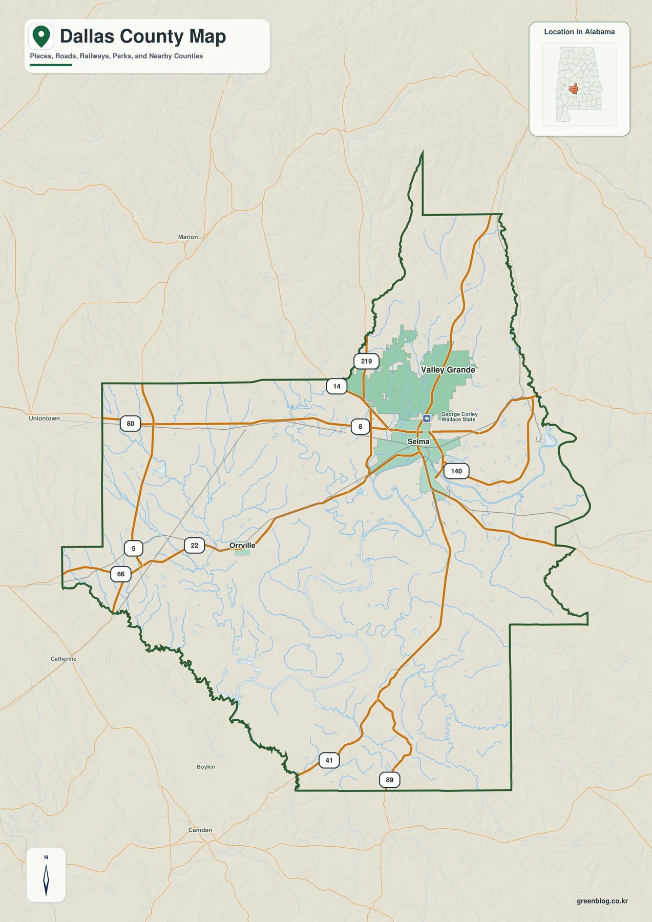
Labels outside the boundary provide useful orientation without suggesting that those places lie in Dallas County. Marion and Uniontown appear to the west, while Boykin and Camden are south or southwest of the county. The surrounding county labels include Hale and Perry to the north, Lowndes and Autauga to the east, Chilton and Wilcox to the west, and Marengo to the southwest. These references are especially helpful because the Dallas County line has several steps, narrow extensions, and curved sections rather than one simple geometric form.
The general map also shows that roads and waterways do not stop at the administrative line. A highway may leave the county and continue toward a nearby town, while a creek may cross the border without any visible change in its course. For classroom or reference use, this distinction matters: the dark green line defines Dallas County, whereas the lighter background supplies regional context.
How Selma Connects with Valley Grande and Orrville
The city-connections map removes most secondary labels so the county’s three incorporated municipalities stand out. Selma is marked as the hub with a population of 17,057. Valley Grande, shown with 4,047 residents, lies about 6 miles north of Selma. Orrville, with 158 residents on the map, is approximately 15 miles southwest of the hub. These figures and distances give the page a simple scale for comparing the county’s urban center with its much smaller municipalities.
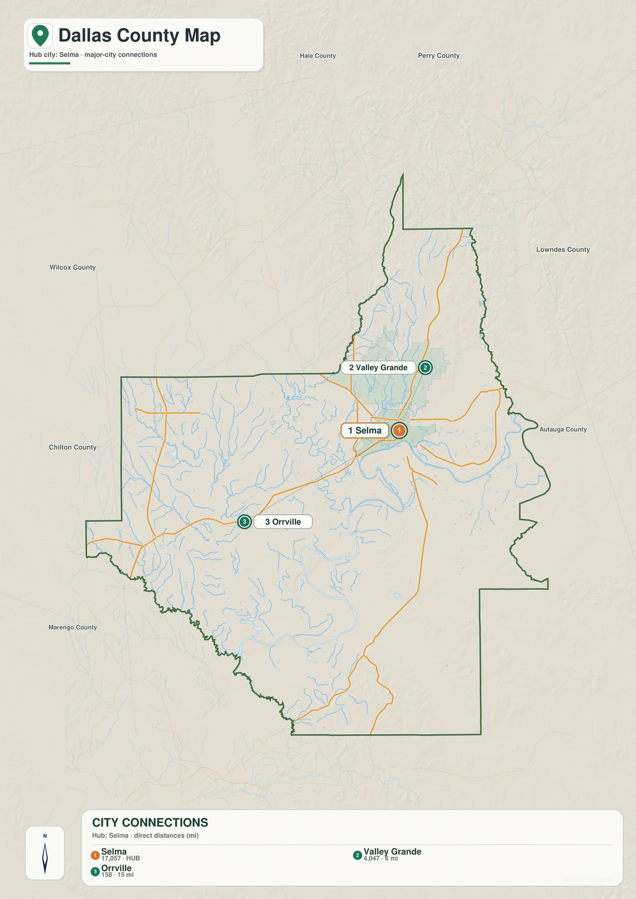
The 6-mile and 15-mile values are direct point-to-point measurements, not mileage along a road. That difference is important in a county crossed by large rivers and winding rural routes. A destination may look close on the page but require a longer drive to reach the correct bridge or highway. Anyone planning a trip should use the map for orientation and then check current navigation directions for the actual route.
Selma’s dominance is visible even without a population table. Roads converge there, the built-up area is larger, and the city sits beside the county’s principal river crossing. Valley Grande represents the short northern extension of the Selma area into more open country. Orrville anchors the broad southwestern section and provides a useful reference for reaching the Cahaba River and Old Cahawba. Together, the three labels explain far more about local settlement than a crowded list of every small community would.
The Alabama–Cahaba River System and Smaller Waters
The Alabama River is the dominant feature on the terrain-and-water map. It enters from the east, bends broadly around the Selma area, and continues through the central and southern part of Dallas County. The Cahaba River approaches from the northwest and joins it farther southwest. Near that confluence, the map shows an especially dense network of channels and low-lying ground. This is the setting of Old Cahawba, the archaeological site associated with Alabama’s first state capital.
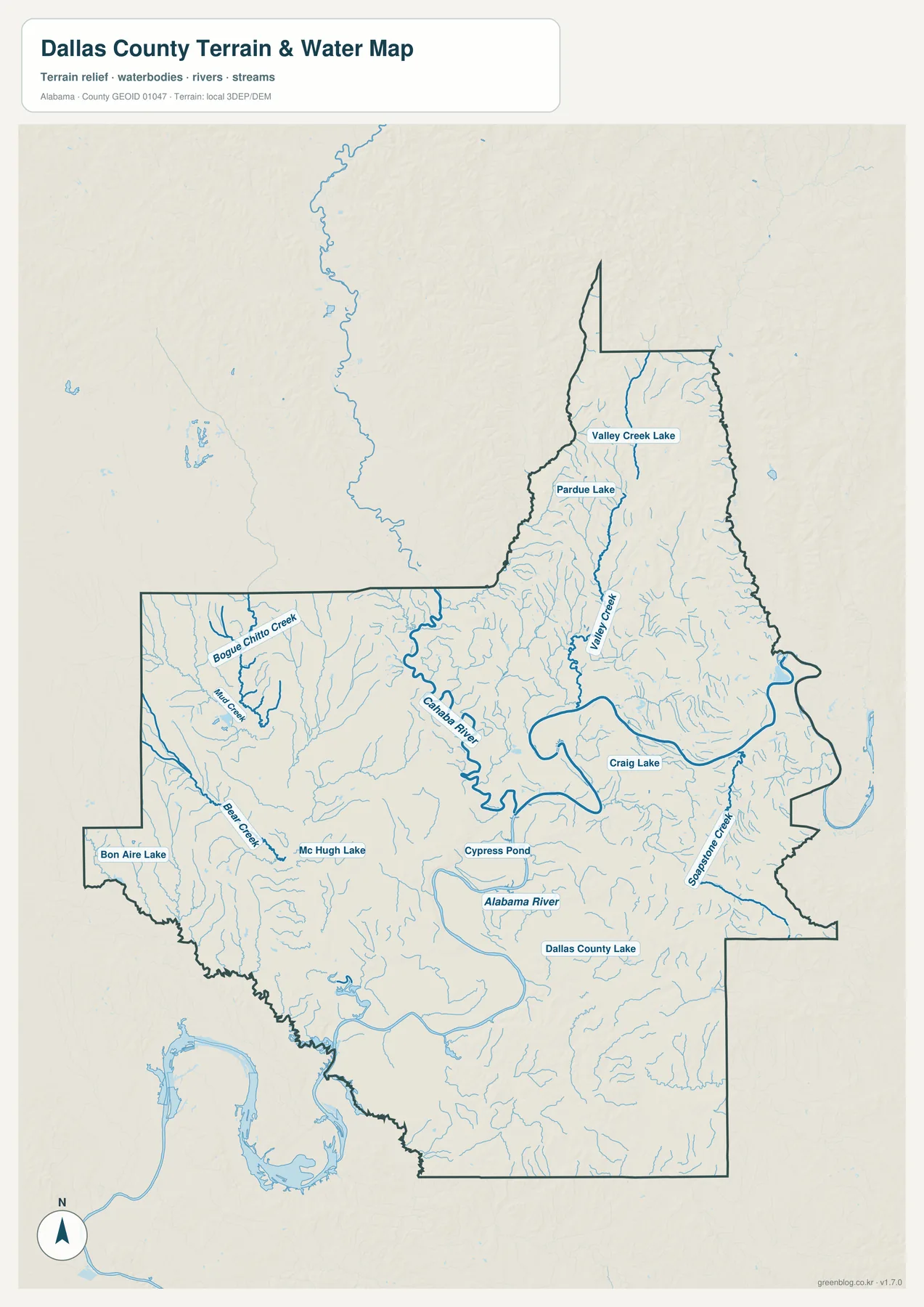
Valley Creek runs through the long northern part of the county, with Valley Creek Lake and Pardue Lake labeled nearby. On the western side, Bogue Chitto Creek, Mill Creek, and Bear Creek feed a fine network of smaller channels. Bon Aire Lake appears near the far western boundary. Mc Hugh Lake and Cypress Pond lie closer to the middle, Craig Lake is east of the central river bend, and Dallas County Lake is farther south. Sopstone Creek provides another clear reference on the southeastern side.
The light-blue tributaries reveal how thoroughly water reaches into the rural interior. Many begin in narrow upland valleys and then join larger creeks or rivers on lower ground. Comparing this map with the road map also shows why some routes curve and why crossings are concentrated in particular places. The Alabama River separates central Selma from communities on the south side, so a bridge can matter more for travel than short straight-line distance.
This map is intended for regional reference. It does not show flood probability, parcel ownership, water depth, channel conditions, or safe navigation routes. A blue line confirms the mapped location of a water feature, but it should not be used by itself to make decisions about boating, construction, insurance, or emergency evacuation. Those activities require current information from the responsible agency.
Elevation from Northern Ridges to River Lowlands
The elevation map uses greens for lower ground and tan or brown shades for higher terrain. Its legend gives an actual county range of roughly 24 to 173 meters, with a mean elevation of 58 meters. The displayed color scale is locally adjusted to make variation inside Dallas County easy to recognize. Because of that local scaling, matching colors on a map of another county do not necessarily represent the same elevation.
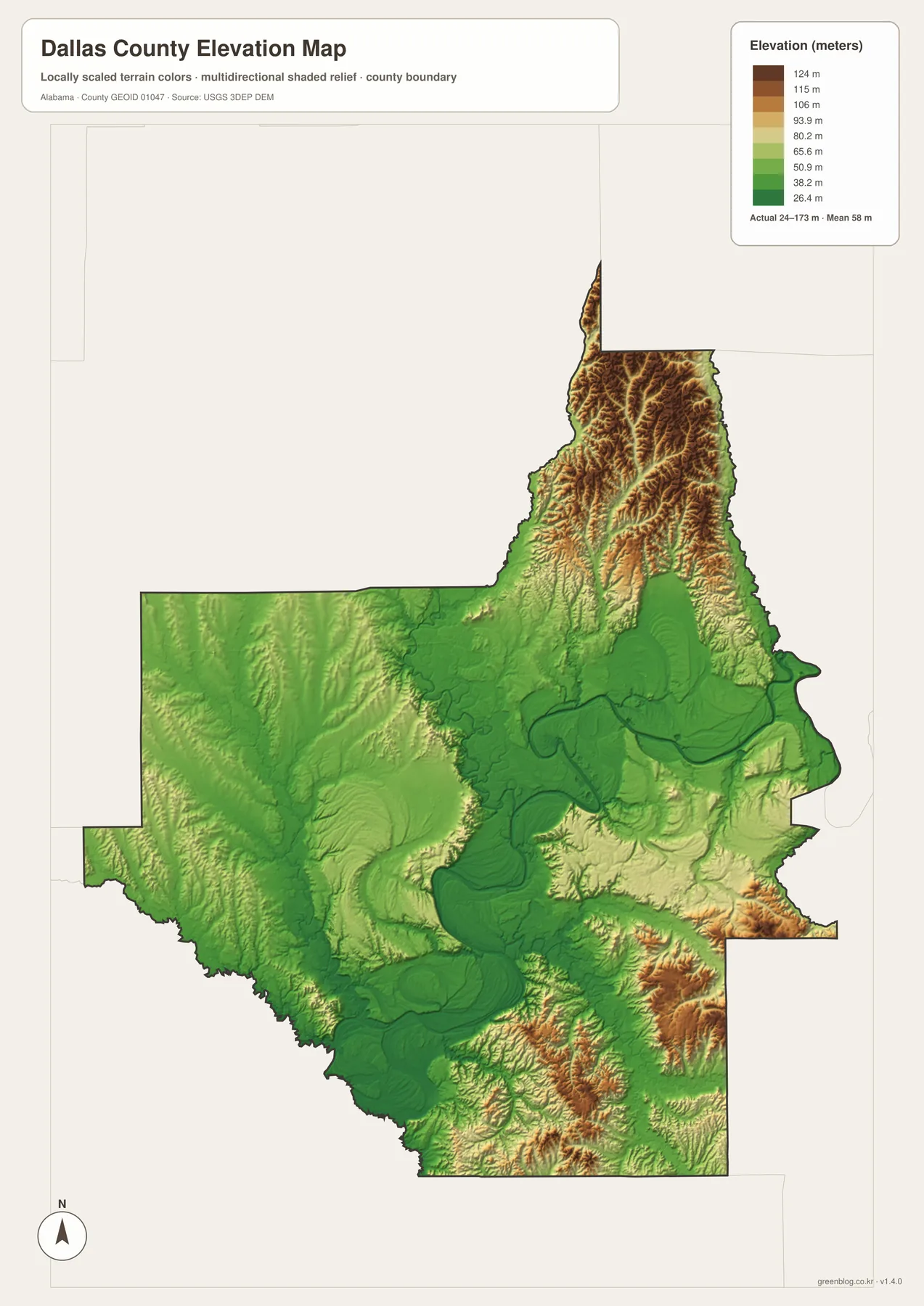
The strongest relief appears in the northern projection. Numerous narrow ridges and valleys create a textured band of brown, tan, and pale green. Higher hills also stand out along parts of the southeastern boundary. Between them, the Alabama River occupies a broad dark-green corridor. Selma sits near the meeting point between northern rolling ground and the lower river landscape, which helps explain why the city’s site looks different from the flatter floodplain farther south.
Western and southwestern Dallas County are generally lower and gentler, although the shaded surface still reveals many small valleys. The Cahaba River descends through this terrain before reaching the Alabama River. When the elevation and water maps are viewed side by side, the fine creek network lines up with depressions between ridges, and the two major rivers occupy the widest low areas. This comparison gives a clearer picture than either map can provide alone.
The elevation layer is a generalized surface made for regional viewing. It is useful for distinguishing hills, valleys, and river lowlands, but it is not a survey or engineering drawing. Do not use a color boundary to determine a property elevation, building grade, or precise slope. Site-specific work requires professional measurements and the appropriate official data.
Choosing the Right Dallas County Map
Use the general map when you need the county outline, major roads, incorporated places, nearby towns, and streams on one page. The city map is faster when the question is simply where Valley Grande and Orrville lie in relation to Selma. For rivers, named creeks, lakes, and the shape of the drainage network, the water map provides the most detail. The elevation sheet is the best choice for comparing northern ridges, southeastern hills, and low ground beside the two major rivers.
A useful classroom sequence begins with the county boundary and U.S. 80, then adds the Alabama River, and finally compares those features with elevation. Students can locate Selma, follow the highway east and west, trace the river through the county, and see why tributaries descend from higher ground. For local-history study, the same maps help place Selma, the Edmund Pettus Bridge corridor, Orrville, and the river confluence near Old Cahawba in one geographic framework.
Printed copies also work well for labeling exercises, route sketches, presentations, and personal reference. Since the source files are high-resolution A3 JPGs, lines and place names remain clearer than they would in a small screenshot. Scale the page to fit a smaller sheet if needed, but keep the original file when you want the sharpest print.
Frequently Asked Questions
Are the city-map distances the same as driving distances?
No. The labels of about 6 miles to Valley Grande and 15 miles to Orrville are straight-line distances from Selma. Road mileage may be longer because of route curves, bridge locations, and the exact start and end points. Use current navigation directions when planning an actual drive.
Why is the Alabama River corridor dark green on the elevation map?
Dark green represents relatively low ground within Dallas County. The Alabama and Cahaba rivers occupy broad lowlands below the northern ridges and southeastern hills. The color does not by itself identify a flood zone, so official flood-hazard information should be consulted for risk decisions.
Where does Old Cahawba fit on these maps?
Old Cahawba is near the place where the Cahaba River joins the Alabama River, southwest of Selma and southeast of Orrville. It is significant as the site of Alabama’s first state capital and is now managed as an archaeological park. The water map is the clearest sheet for understanding its river setting.
Map File Information
Dallas County A3 Map Files
- Included Files: 4 high-resolution A3 JPG maps described on this page
- File Type: JPG files in a ZIP archive
- Intended Use: Printing, education, presentations, and map-based projects
Related Maps
- Autauga County Map
- Barbour County Alabama Map
- Butler County Alabama Map
- Alabama Population Density Map: Urban Clusters, County Totals and a Decade of Change
Sources and Further Reference
- Dallas County official municipalities information
- Alabama Department of Transportation county road maps
- USGS National Hydrography
- USGS 3D Elevation Program
- Alabama Historical Commission: Old Cahawba
- National Park Service: Edmund Pettus Bridge
Green Map creates custom-edited map images using open geographic data sources such as geoBoundaries, Natural Earth, OpenStreetMap, and government open data. These maps are edited visual materials, not raw data files, and are provided for education, documents, presentations, and graphic reference.