Autauga County sits in central Alabama, but its map is easier to understand when you look beyond Prattville alone. Prattville occupies the southeastern side of the county, where the most visible urban area and several major roads are concentrated. West and north of the city, the county opens into a much larger area with fewer settlements, many small creeks, and a more broken pattern of valleys and ridges. The Alabama River follows the southern edge, while tributaries descend from the interior toward lower ground. This page explains those relationships with county, city, water, and elevation views, and the high-resolution A3 JPG files are available together in a downloadable ZIP.
If you are new to Autauga County, three places make useful reference points: Prattville in the southeast, Autaugaville farther west, and Billingsley near the northern boundary. Their positions show that the county seat is not close to the geographic center of the county. A large amount of territory extends west and north of Prattville, and the landscape becomes less urban as you move away from the southeastern corner. The maps below are designed for county-scale reference rather than turn-by-turn navigation, so they are most useful for understanding where communities, roads, streams, and higher or lower terrain sit in relation to one another.
Table of Contents
Prattville, Major Roads, and the County Outline
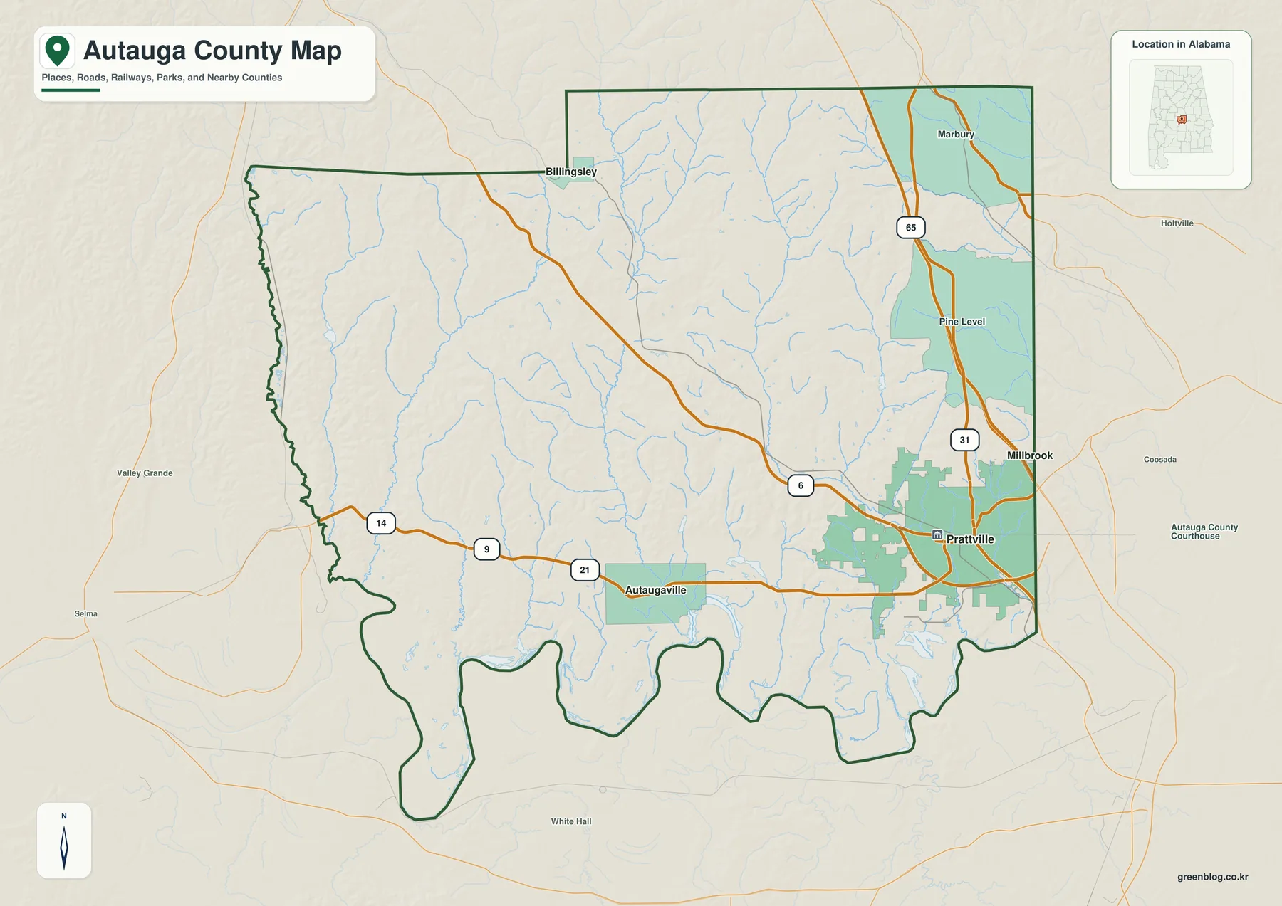
Prattville is the easiest place to find on the reference map because the built-up area is clearly visible in the southeast. I-65 and U.S. 31 pass near the city and create a strong north-south reference line. Looking west from Prattville, Alabama 14 leads toward Autaugaville, while Pine Level and Marbury appear to the north and northeast. This arrangement makes an important point immediately: Prattville is a county seat near the eastern side of Autauga County, not a city located in the middle of the county outline.
Billingsley lies close to the northern boundary, while the county’s western side faces Dallas County. Lowndes and Perry counties appear to the southwest and south, and Elmore and Montgomery counties are close to the eastern side. Those surrounding names help orient the map even if you are not familiar with the shape of Autauga County. The southern edge is especially distinctive because it bends repeatedly instead of following one long straight line. The Alabama River and the lowlands along it help give this part of the county its irregular outline.
The road layer is intentionally selective. It highlights the highways and routes that are most useful for understanding the county at a glance rather than trying to reproduce every local street. For travel planning, live traffic, or driveway-level directions, a current navigation service is the better tool. Here, the value of the reference map is broader: it shows how Prattville relates to the rest of the county, where the larger road connections run, and why the western and northern parts of Autauga County feel much more open than the southeastern corner.
Where Autaugaville and Billingsley Sit Relative to Prattville
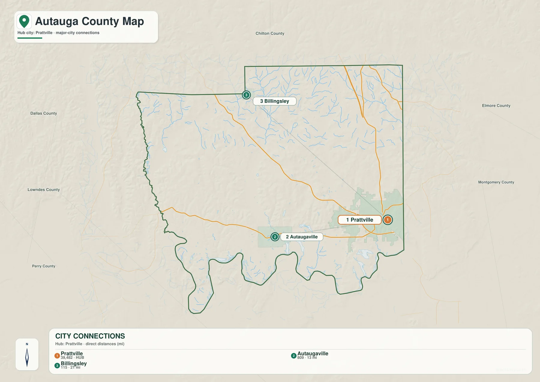
The city view strips away much of the extra detail and focuses on the relative positions of Prattville, Autaugaville, and Billingsley. Autaugaville is west of Prattville, and the map marks the straight-line separation at about 13 miles. Billingsley is northwest of the county seat and is marked at about 21 miles from Prattville. Those values are not driving mileage. They connect the mapped points directly, so an actual road trip will usually cover a longer distance depending on the route, the exact starting point, and the final destination.
The spacing between the three communities also makes the county’s proportions easier to grasp. Prattville and Autaugaville occupy roughly the same southern part of the county, which emphasizes the county’s east-west width. Billingsley sits much farther north, showing how much territory extends toward the Chilton County side. Someone who knows only Prattville may picture Autauga County as a compact suburban area, but the city map makes clear that the county includes a broad interior between these communities, with many smaller roads, streams, wooded areas, and rural landscapes.
The numbered city markers are simply a visual key. They do not rank the communities and do not suggest a travel order. For a classroom activity or presentation, a useful approach is to identify Prattville first, place Autaugaville to the west, then locate Billingsley toward the northwest. Returning to the county reference map afterward adds the road context, including I-65, U.S. 31, and Alabama 14. This keeps the explanation simple without reducing the county to a list of place names.
Creeks, Lakes, and the Alabama River
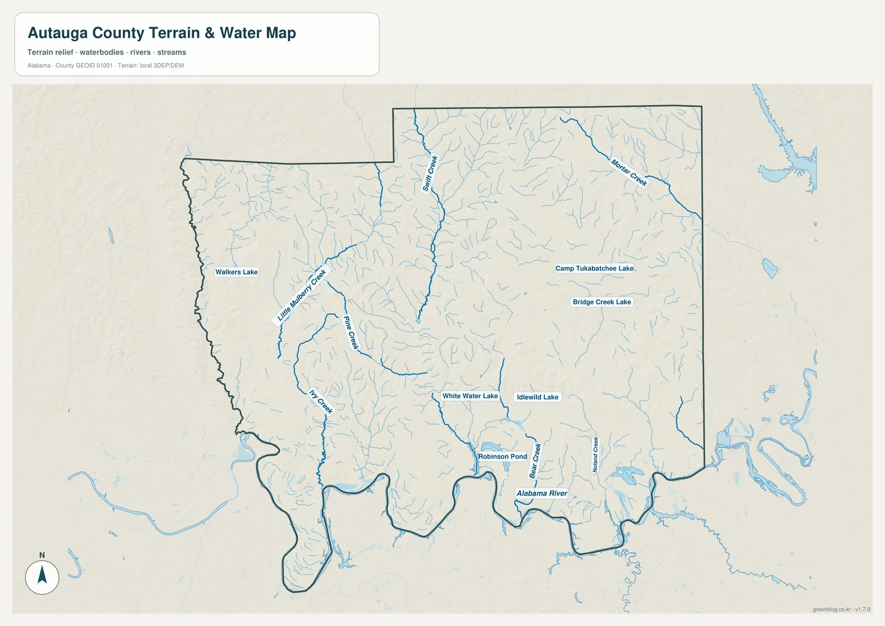
The water map changes the emphasis from roads and communities to the county’s drainage network. The Alabama River is the dominant feature along the south, and many interior streams descend toward lower ground connected with that river system. Once the road layer is removed, the number of small tributaries becomes much more obvious. Northern and western Autauga County are crossed by many short branches, which helps explain why the terrain there is divided into narrow valleys rather than forming one smooth, uninterrupted surface.
Several named waterways provide useful anchors. Little Mulberry Creek, Pine Creek, Ivy Creek, Pintlala Creek, and Mortar Creek appear across the interior, while Bear Creek and Walnut Creek are labeled in the southeastern part of the county. Numerous smaller tributaries connect to these larger channels. Their pattern is especially helpful when the water map is compared with the elevation map, because many streams occupy the greener, lower corridors between higher ridges. You do not need technical drainage terminology to see the relationship: water generally follows the lower paths through the landscape.
The map also labels smaller water bodies, including Walkers Lake, Camp Tukabatchee Lake, Bridge Creek Lake, White Water Lake, Idlewild Lake, and Robinson Pond. These features are useful local reference points, but their presence on the map does not tell you whether public access is available or whether a lake is suitable for boating, fishing, or swimming. The water map also does not define flood zones, property boundaries, current water levels, or safe crossings. Those questions require current information from the appropriate agencies or site-specific sources.
Lower Ground in the South, Higher Ridges in the North
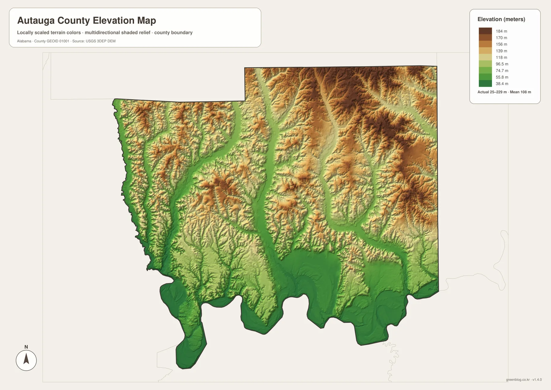
Elevation gives the county a very different appearance from the road map. Much of the south is green, especially near the Alabama River and along the lower ends of tributary valleys. Moving north, the colors shift through lighter green and yellow into tan and brown as the land becomes higher. The legend shows elevations of roughly 25 to 229 meters, with an average near 108 meters. The exact numbers provide context, but the clearest takeaway is the broad contrast between lower southern terrain and the more strongly ridged northern half of the county.
The northeast contains some of the most noticeable high ground. Narrow ridges are separated by green valleys that branch through the hills, and similar patterns appear across the west. The uplands are therefore not one flat plateau. Creeks have cut many valleys through them, leaving higher strips of land between neighboring channels. Farther south, those valleys become broader and the overall terrain drops toward the Alabama River. That transition is one reason the southern part of the elevation map looks smoother and greener than the north.
Comparing the water and elevation views side by side is useful because the connection between streams and low ground becomes easy to see. Blue tributaries on the water map often match the green corridors on the elevation surface, while warmer colors occupy the ridges between them. This simple comparison explains much of the county’s physical geography without requiring a specialized GIS background. It also helps a reader understand why the northern interior contains so many short creeks and why the southern river area has a broader lowland appearance.
The elevation image is a county-scale reference, not a survey. It cannot give the precise elevation of a parcel, the grade of a construction site, or the slope needed for drainage design. Small variations may also be generalized so the larger terrain pattern remains readable at this scale. For engineering, property, or site-planning decisions, use the underlying elevation data and appropriate professional measurements. For general geographic study, however, the map provides a clear way to compare the Alabama River lowlands with the ridged country farther north.
Choosing the Best Map for Your Purpose
The best starting point depends on the question, not on working through the files in a fixed order. Someone trying to place Prattville within the county will naturally begin with roads, nearby communities, and the county outline. A reader interested in the Alabama River or the smaller creeks will need a view that gives water features more space, while the north-to-south change in terrain is easier to understand when height becomes the main focus. Framing the maps around real questions keeps the page useful without turning the article into a list of map versions.
In a lesson or presentation, a smoother approach is to follow the story of the county. Prattville provides a familiar starting point, then Autaugaville and Billingsley show how far the county extends west and north. From there, the Alabama River and the branching creeks explain much of the lower ground, and the higher northern ridges make more sense once those valleys are visible. The maps support that story at different moments instead of functioning as four separate items that must be introduced one after another.
The downloadable originals are 3638 × 2572 pixel JPG files in landscape orientation, suitable for A3 printing. They also work well in slides, classroom handouts, reports, and personal map projects where a larger image is useful. If a small creek label or a ridge pattern matters, place one map at a generous size instead of shrinking several images onto the same page. Printer margins and automatic scaling differ, so checking the print preview before producing an A3 copy will help preserve the intended layout.
A useful way to remember Autauga County is to connect a few simple features rather than memorize every label. Prattville sits in the southeast near the strongest road connections. Autaugaville is west of the county seat, and Billingsley lies much farther north. The Alabama River forms the major southern water feature, while many creeks cut through the interior. Higher, more deeply divided terrain is concentrated toward the north and northeast. Together, those observations give a clear picture of the county before you move into more detailed local information.
Using Neighboring Counties to Orient the Map
A county map becomes easier to read when the surrounding counties are treated as reference points rather than background labels. Elmore County and Montgomery County are on the eastern side of Autauga County, while Dallas County is to the west. Lowndes and Perry counties appear around the southwest and southern side, and Chilton County is north of the Billingsley area. If you locate those neighbors first and then find Prattville, the county’s position in central Alabama becomes much easier to picture. This also explains why Prattville looks close to an outer edge instead of sitting near the middle of the county shape.
The southern boundary is another useful visual clue. It bends in and out much more than many of the straighter boundary segments to the north and west. The Alabama River and its adjacent lowlands are closely associated with that irregular southern edge. When comparing Autauga County with nearby county maps, remembering the winding southern outline and the concentration of development near the southeast provides a quick way to recognize the county. These simple visual cues are often more useful than trying to memorize every boundary line or road number.
Major highways should also be read as orientation tools rather than a complete transportation inventory. I-65 and U.S. 31 create a clear north-south reference near the eastern side, and Alabama 14 helps connect Prattville with the interior toward Autaugaville. Many smaller local roads are not emphasized because the map is designed to stay readable at county scale. If your purpose is to understand the broad arrangement of communities and neighboring counties, that simplified road network is enough. If your purpose is to drive to a specific address, a current navigation map should take over once the county-scale relationship is clear.
What the Water and Elevation Maps Reveal Together
The water and elevation views become especially useful when the same area is compared between them. In the northern half of the county, the water map shows many branching tributaries. The elevation surface shows that those blue lines generally occupy lower green corridors between higher ridges. Farther south, tributary valleys widen and descend toward the broad low ground near the Alabama River. The relationship is straightforward and visible without technical analysis: streams tend to follow lower terrain, while the higher ground remains between neighboring valleys.
This comparison also explains why northern and southern Autauga County have such different visual character. The north contains more closely spaced ridges and valleys, so the drainage network breaks into many small branches. The south is lower overall and contains broader areas of smoother terrain near the river. Prattville attracts attention on the reference map because of its roads and developed area, but the physical landscape is organized by a much larger north-to-south change in relief. Recognizing that pattern makes it easier to understand why the road, water, and elevation views do not all emphasize the same parts of the county.
The smaller named lakes and ponds can also be used as local anchors when moving between maps. Walkers Lake appears toward the west, while Camp Tukabatchee Lake and Bridge Creek Lake are farther east. White Water Lake and Idlewild Lake are closer to the central and southern interior, and Robinson Pond lies nearer the southern part of the county. Their labels help readers identify portions of the water map, but they are not a guide to recreation access. Ownership, boat access, fishing rules, water levels, and current conditions require separate and up-to-date sources.
Printing and Classroom Use
The A3 landscape format provides more room for labels than a small web preview, which is useful when the map will be printed for a lesson, report, or display. The county reference map works well for a general introduction because roads, communities, and neighboring counties appear together. The city view is cleaner when the goal is simply to compare Prattville, Autaugaville, and Billingsley. The water image gives stream names more room, and the elevation image uses color to make low and high areas easy to distinguish. Selecting one map for one clear purpose usually produces a better handout than shrinking every theme into a small grid.
A presentation can also be organized around questions instead of map types. Start by asking where Prattville sits within the county and answer that with the reference map. Next, ask how far the county extends beyond the county seat and use the city view to place Autaugaville and Billingsley. A question about rivers and creeks naturally leads to the water map, while a question about why the north looks more divided leads to the elevation image. This approach gives the audience a reason to look at each map and prevents the page from feeling like a repetitive list of four products.
The downloadable JPG files are large enough for A3 landscape output, but print quality still depends on the software and printer settings. Keep the original aspect ratio when placing an image in a document so the county shape is not stretched. Check the print preview for unwanted cropping, especially around legends and labels near the edges. If a creek name or terrain ridge is important, use the map at a larger size rather than heavily compressing it. The elevation legend should remain visible because the colors have little meaning without the height scale beside them.
County-Scale Reference versus Site-Specific Data
These maps are designed to summarize a whole county on one page. That means some local detail must be simplified. Minor roads and very small tributaries may not be labeled, community symbols represent general locations, and terrain colors summarize elevation across a broad area. This is appropriate for education, geographic reference, and comparison, but it is not the level of detail needed for a parcel boundary, construction project, or emergency decision. Understanding that difference helps readers use the maps confidently without expecting them to replace specialized local data.
For a driving route, consult a current road service after using the county map to understand the general direction. For flood risk, use official flood information and current hydrologic sources. Property boundaries require cadastral or survey records, and exact slopes or elevations require detailed terrain data and measurements. By contrast, the maps on this page are well suited to questions such as where Prattville lies, how Autaugaville and Billingsley are positioned, which streams cross the county, and how the southern lowlands differ from the higher northern terrain.
Because the full-resolution files can be downloaded, readers do not have to rely on the reduced web previews when labels or terrain details matter. A classroom handout may need a clean view of communities, while a local-history presentation may focus on the river corridor or the physical setting of the county. The useful point is not that the files form a numbered set, but that each one can be pulled into a project when its information is relevant. That makes the download practical for both quick reference and larger printed or presentation materials.
Frequently Asked Questions
Why does Prattville appear so close to the county edge?
Prattville is in southeastern Autauga County rather than near the geographic center. The county extends much farther west toward Autaugaville and north toward Billingsley, so the full map naturally leaves a large amount of county territory on those sides of the county seat.
Are the distances on the city map driving miles?
No. The roughly 13-mile value to Autaugaville and 21-mile value to Billingsley are straight-line measurements between the mapped points and Prattville. Actual road mileage depends on the route and the exact starting and ending locations, so current navigation data should be used for travel planning.
Can the water and elevation data guide property or engineering decisions?
No. These are county-scale reference maps. The water information does not establish flood status, property lines, access rights, or current water conditions, and the elevation image is not survey-grade. Parcel, construction, drainage, or engineering work requires current detailed data and appropriate professional measurements.
Map File Information
Autauga County Four-Map JPG Set · A3 landscape · 3638 × 2572 px · 4 JPG files in one ZIP
- Included Files: County, city, water, and elevation maps
- File Type: High-resolution JPG files in one ZIP archive
- Intended Use: Printing, education, presentations, and map-based projects
Related Maps
Sources for Autauga County Maps
These references provide supporting information for county boundaries, roads, streams, elevation, population, and local geographic background. The maps on this page are simplified for clear county-scale viewing, so the original sources are the better choice when you need the latest official data or more detailed measurements.
- U.S. Census Bureau TIGER/Line — county and place boundaries
- Alabama Department of Transportation — county road maps
- USGS National Hydrography — streams and water bodies
- USGS 3D Elevation Program — elevation data
- U.S. Census Bureau QuickFacts — Autauga County profile
- Encyclopedia of Alabama — Autauga County history and geography
- Alabama Population Density Map: Urban Clusters, County Totals and a Decade of Change
- Autauga County Alabama Land Cover Map – Wooded West, Prattville Hard Surfaces & Wetlands
Green Map creates custom-edited map images using open geographic data sources such as geoBoundaries, Natural Earth, OpenStreetMap, and government open data. These maps are edited visual materials, not raw data files, and are provided for education, documents, presentations, and graphic reference.