A Chiayi County Map has an unusual visual center: a gray gap where Chiayi City sits as a separate jurisdiction. Around that enclave, 18 county divisions extend from small western coastal areas through a tightly divided central belt to the broad Alishan shape in the east. The result is a long east–west map with two very different scales of administration on one page.
The collection contains three 1200-by-849-pixel landscape images arranged for A3 use. The color sheet separates all 18 divisions with muted fills, the black-and-white sheet keeps their names and boundaries, and the outline removes every geographic label. Each Chiayi County Map uses the same geometry, making it possible to move from visual reference to print study and then to recall or annotation.
These images focus only on county administration. They do not label the Taiwan Strait, Yunlin County, Tainan City, Nantou County, Kaohsiung City, roads, terrain, railways, rivers, or tourist sites. Taibao and Puzi appear as names inside their administrative shapes rather than as city-point symbols, and the separate Chiayi City area is left unlabeled.
Table of Contents
Why This Chiayi County Map Is Useful
Chiayi County lies in southwestern Taiwan and reaches from the island’s western coast toward mountainous eastern territory. That change in width and terrain is not encoded with elevation shading, but it influences the administrative pattern visible on the page. Western divisions are comparatively compact, while Alishan and Dapu occupy much larger eastern and southern spaces.
The county surrounds Chiayi City, which is administratively separate. On the artwork, the city appears as a gray cutout between Taibao, Minxiong, Zhuqi, Fanlu, Zhongpu, and Shuishang. Because it has no text label, readers unfamiliar with the area might mistake the opening for missing map data. Recognizing the enclave explains the county’s interrupted-looking center.
The Chiayi County Map also clarifies the relationship between the two county-administered cities. Taibao lies immediately west of the enclave and serves as the county seat; Puzi sits farther west. Neither label refers to Chiayi City. Keeping these three names separate is essential when describing local government, addresses, or a county-versus-city map.
At the western edge, Dongshi and Budai reach the coast, with Yizhu farther south and Liujiao near the northwestern side. The map’s eastern half is anchored by Meishan, Zhuqi, Fanlu, Zhongpu, Dapu, and Alishan. This west-to-east reading path is more useful than treating the 18 names as an unstructured list.
Map Versions Included
All three sheets preserve the long county silhouette, the coastal indentations, the central city enclave, and the same internal division network. Their information levels differ:
- Pastel map with all 18 county division names
- Black-and-white map retaining the full label set
- Blank outline with boundaries but no administrative names
The colors serve only to separate adjacent areas. They do not communicate population, elevation, land use, political affiliation, or an official regional classification. The monochrome version remains a labeled reference, while the outline provides the only answer-free sheet. None of the three is a road, physical, tourist, or navigation map.
Color Administrative Map
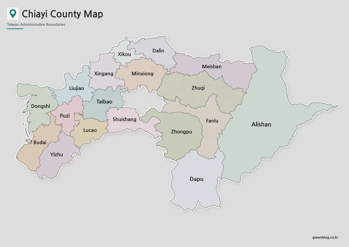
Muted fills help distinguish the crowded western and central divisions. Puzi, Taibao, Lucao, Shuishang, Liujiao, Dongshi, Budai, and Yizhu meet within a relatively small portion of the page, so color makes their boundaries easier to follow. Farther east, the broad Alishan fill contrasts sharply with these compact polygons.
On this Chiayi County Map, the gray background flows into the Chiayi City enclave. A white county border outlines the outer silhouette, while thin dark lines separate divisions inside it. The graphic does not assign a color or label to Chiayi City because that jurisdiction is outside the county’s 18-division set.
Use the color sheet when viewers need to compare the entire pattern quickly. It can introduce the two cities, the two urban townships, the rural townships, and the large Alishan area before a more detailed explanation. Any custom data layer should use its own legend so the decorative pastel fills are not mistaken for values.
Black and White Printable Map
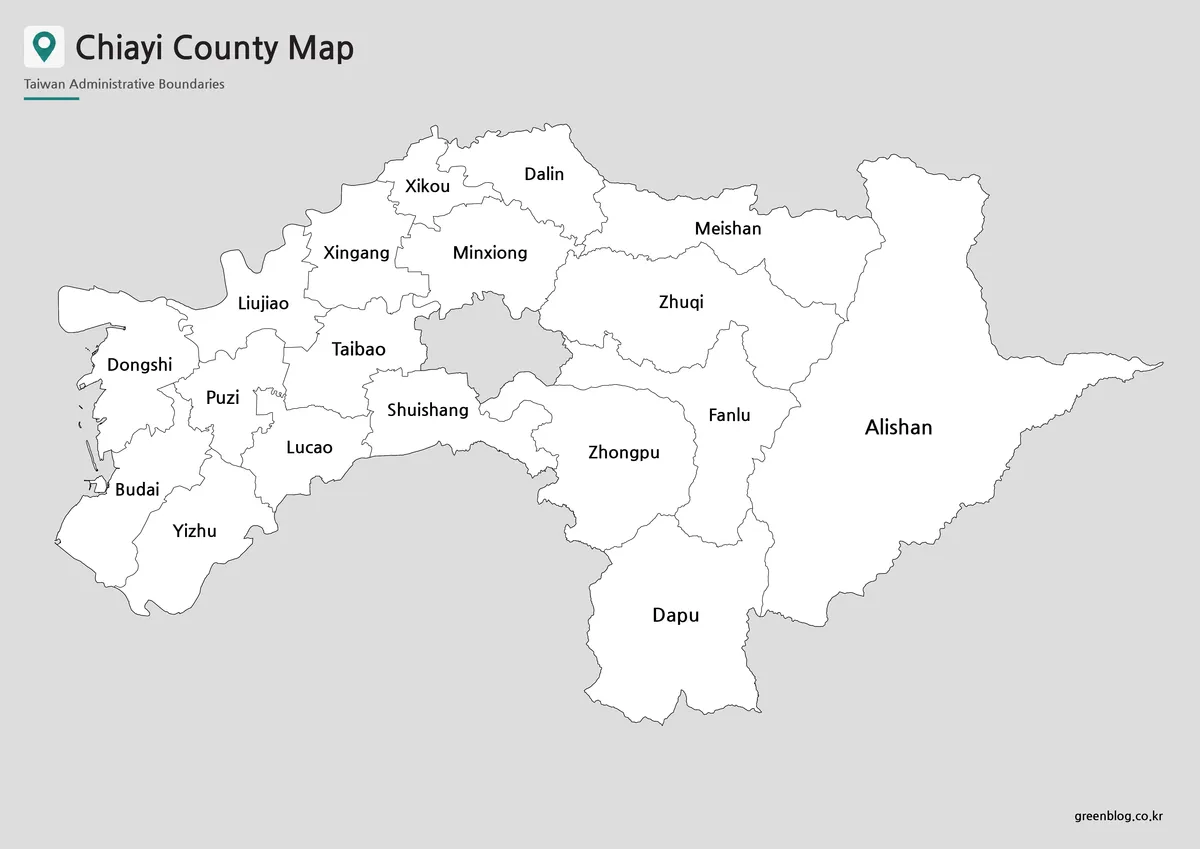
The monochrome image replaces every pastel fill with white and keeps the surrounding background gray. Names and boundary lines therefore become the primary reading elements. Alishan, Dapu, Zhuqi, Meishan, and other larger areas provide ample label space, whereas western names such as Puzi, Budai, and Dongshi sit within tighter forms.
The black-and-white Chiayi County Map fits reports, labeled worksheets, reference pages, and grayscale handouts. Before printing a class set, test the chosen paper size and inspect the thin western coastline, small gaps, and compact labels. The map is arranged for A3 landscape use, but reducing it significantly can make the western boundary network harder to distinguish.
Because every county division is already named, the sheet works best as a checking reference rather than a blank quiz. It can sit beside the outline while students verify their labels or help a writer identify which county area surrounds a particular side of Chiayi City. It does not mark exact town-center locations.
Blank Outline Map for Editing
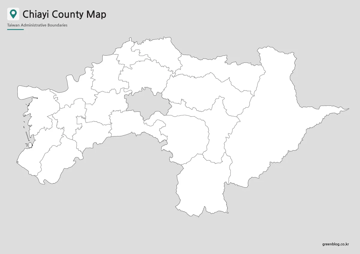
The outline removes the 18 names but preserves the entire administrative geometry. The central gray opening remains visible, as do the small western coastal features and the long eastern projection of Alishan. Readers can therefore practice the actual spatial arrangement rather than label a simplified county-only silhouette.
A blank Chiayi County Map can support several concrete tasks: labeling Taibao and Puzi without confusing them with Chiayi City, grouping coastal and eastern divisions, or coloring selected administrative types. A designer may add routes or points, but those features must come from a current source because the outline contains no roads, attractions, or city coordinates.
Keep an untouched duplicate before editing. Add a legend when colors represent data, preserve the image’s aspect ratio during export, and avoid covering narrow boundaries with large symbols. The supplied map is a raster image rather than a confirmed vector file, so excessive enlargement may soften lines and labels added later.
Chiayi County Administrative Areas
On the Chiayi County Map, the 18 divisions consist of Taibao and Puzi; the urban townships of Budai and Dalin; and Dapu, Dongshi, Fanlu, Liujiao, Lucao, Meishan, Minxiong, Shuishang, Xikou, Xingang, Yizhu, Zhongpu, Zhuqi, and Alishan. Alishan is the mountain indigenous township. The images omit suffixes such as “City” and “Township” to keep the English labels compact.
A quick location sequence helps organize the list. Xikou and Dalin sit along the north, followed eastward by Meishan. Minxiong and Xingang lie below that northern band. Liujiao, Dongshi, Puzi, Budai, Lucao, and Yizhu form much of the west; Taibao and Shuishang border the enclave; and Zhuqi, Fanlu, Zhongpu, Dapu, and Alishan lead toward the east and south.
Romanization can differ among sources. The artwork uses Liujiao, Xikou, Xingang, Zhuqi, Zhongpu, and Shuishang, while other official materials may show Lioujiao, Sikou, Singang, Jhuci, Jhongpu, or Shueishang. Follow the spelling required by the institution or project, and avoid treating a spelling variation as a different administrative area.
Practical Uses for the Map
For a geography lesson, introduce the color map, use the monochrome sheet for close name reading, and finish with the outline for recall. Ask learners to identify the Chiayi City enclave before labeling the county divisions around it. Shared geometry allows answers to be checked without changing orientation or scale.
When printing the Chiayi County Map at A3, choose landscape orientation and use “fit to page” rather than stretching width and height independently. Preserve enough margin for the title and western coastline. On smaller paper, confirm that Puzi, Lucao, Dongshi, and other compact western labels remain legible.
Presentation and infographic users should match the sheet to the task. Color offers fast division separation; monochrome supports a restrained document; and the outline accepts sourced custom overlays. A project about elevation, transit, tourism, population, or neighboring jurisdictions requires additional verified data rather than assumptions based on the administrative shapes.
Frequently Asked Questions
The protected answers address versions, printing, editing, and the county–city distinction. Visually, the Chiayi County Map shows Chiayi City only as an unlabeled gray enclave; the 18 printed names all belong to Chiayi County.
What versions are included in this Chiayi County map collection?
The collection includes a color map, a black and white map, and an outline map of Chiayi County.
Can I print the Chiayi County map in A3 size?
Yes. The map is prepared as an A3 layout, making it suitable for large printed reference sheets, classroom materials, and presentation boards.
Is the outline map useful for editing?
Yes. The outline version is designed as a blank boundary map. You can add colors, labels, route markers, data points, or project notes.
What is the difference between Chiayi County and Chiayi City?
Chiayi City is a separate administrative area. Chiayi County surrounds and extends beyond it, covering coastal, inland, and mountain-side regions.
Who may find this map useful?
Teachers, students, travel writers, bloggers, designers, and presentation creators can use the map for educational, printable, and visual reference projects.
Map File Information
The download contains the three Chiayi County administrative map views shown on this page, each using the same 18-division framework and central enclave.
- Included Versions: Color labeled map, black-and-white labeled map, and blank outline map
- Printable Size: Maps arranged for A3 landscape use
- File Type: Image files
- Intended Use: Administrative study, worksheets, presentations, reports, labeling, and sourced overlays
Additional Resources
- Taiwan Chiayi District Prosecutors Office: Jurisdictional Area: Review an official English list of Chiayi County’s 18 divisions and the separate status of Chiayi City.
Related Maps
Green Map creates custom-edited map images using open geographic data sources such as geoBoundaries, Natural Earth, OpenStreetMap, and government open data.
These maps are edited visual materials, not raw data files, and are provided for education, documents, presentations, and graphic reference.