A Yunlin County map has to explain two patterns at once: a long western coast facing the Taiwan Strait and a compact network of 20 local divisions stretching inland toward Gukeng and Linnei. The supplied collection does this with three 1200 × 849 images—a labeled color map, a labeled black-and-white map, and an unlabeled version that keeps the internal administrative boundaries.
The county occupies a central-western position in Taiwan. Changhua is shown beyond the northern edge, Nantou lies to the east, Chiayi appears to the south, and the Taiwan Strait fills the western side. Within Yunlin, broad coastal divisions contrast with smaller inland areas clustered around Huwei, Douliu, and Dounan. That change in size and shape is much easier to understand visually than from a place-name list.
This Yunlin County map set is intended for readers who need a practical administrative reference rather than a transport or terrain map. Teachers can compare the 20 divisions, students can practice labeling them, and presentation creators can choose between color separation and a quieter monochrome design. The images do not show roads, railways, rivers, elevation, tourist sites, distance scales, or city-center markers, so those details should be verified and added separately when a project requires them.
Table of Contents
Map Overview
Yunlin County is organized into one city, five urban townships, and 14 rural townships. Douliu is the county’s only city and the seat of the county government. The five urban townships are Dounan, Huwei, Xiluo, Tuku, and Beigang. The remaining 14 are Mailiao, Lunbei, Erlun, Citong, Linnei, Taixi, Baozhong, Dongshi, Sihu, Yuanchang, Dapi, Gukeng, Kouhu, and Shuilin.
Reading the Yunlin County map from west to east reveals a useful orientation pattern. Mailiao, Taixi, Sihu, and Kouhu meet the coast; Dongshi and Shuilin sit immediately inland from parts of that shoreline; Huwei, Tuku, Yuanchang, Dounan, and Dapi occupy the central belt; and Douliu, Linnei, and Gukeng form the eastern side. Xiluo, Erlun, Lunbei, and Citong help define the northern tier, while Beigang lies near the southern boundary.
The English spellings in the artwork follow familiar romanized forms such as Douliu, Xiluo, Citong, Taixi, Baozhong, Dongshi, Sihu, and Shuilin. Yunlin County Government’s English directory uses some alternate spellings, including Douliou, Siluo, Cihtong, Taisi, Baojhong, Dongshih, Sihhu, and Shueilin. These are spelling variants for the same local administrations, not extra divisions. That distinction is helpful when matching the map to official English pages or search results.
Included Map Versions
The three images share the same landscape proportions and geographic frame. Neighboring areas remain visible around the county, which keeps the western coastline and adjoining Changhua, Nantou, and Chiayi context from being lost. Their information density differs, however, so each file serves a separate task.
- Color version: all 20 division names and boundaries, with a separate fill for each area.
- Black-and-white version: the same labels and boundary network without colored administrative fills.
- Blank-label version: all internal division lines remain, but Yunlin and neighboring-area names are removed.
Select the color image for immediate visual comparison, the monochrome file for text-heavy documents and grayscale output, or the blank-label file when learners or editors need to supply names and thematic information. Because every preview measures 1200 × 849 pixels, one version can replace another in a layout without changing the image box’s proportions.
Color Yunlin County Map
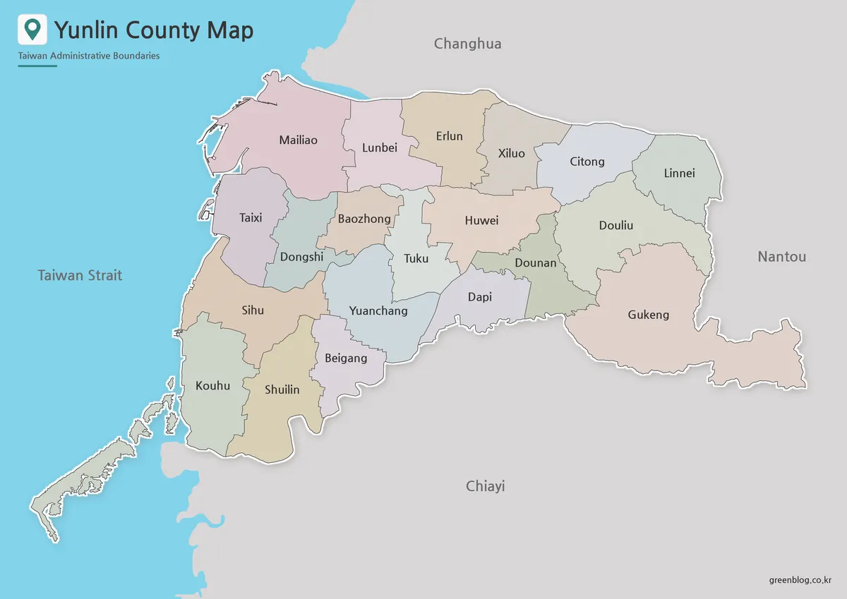
The color image makes the irregular administrative mosaic readable without adding a legend. Each local division receives a contrasting pastel fill, while thin lines preserve the shared borders. The colors are categorical only: they do not encode population, land use, elevation, election results, or administrative rank. Douliu City is not given a special symbol, and the five urban townships are not visually grouped as a separate class.
Several local shapes become especially clear in this treatment. Gukeng extends across a large, irregular southeastern area; Douliu sits immediately to its north; narrow or compact central divisions meet around Huwei, Tuku, Dounan, Yuanchang, and Dapi; and Kouhu includes a distinctive southwestern coastal edge. The pale-blue Taiwan Strait also separates the county’s coastline from the gray land context outside Yunlin.
For a classroom screen or presentation, the color Yunlin County map is the fastest way to point out relative position. A presenter can trace the coastal sequence from Mailiao to Kouhu, compare the northern Xiluo–Citong–Linnei line, or show how the county seat relates to Gukeng and Dounan. If colors are assigned a new meaning in an edited graphic, add a clear legend so readers do not confuse the original decorative palette with project data.
Black and White Printable Version
The black-and-white Yunlin County map retains every division label and internal boundary while removing the pastel fills. It is best treated as a labeled reference sheet, not a blank quiz. The simplified appearance reduces competition between labels and background color, which can help when the image is placed beside explanatory text or reproduced on a monochrome office printer.
Line clarity matters in the center of the county, where several short boundaries and nearby names occupy limited space. Preserve the original aspect ratio and avoid shrinking the image until Huwei, Tuku, Dounan, Yuanchang, and Dapi become difficult to distinguish. A trial print at the intended size is sensible because printer quality, page margins, and document scaling can affect the thinnest lines.
This file can serve as an answer key for an exercise made from the blank-label version. It is also suitable for a report in which readers need to verify spellings while following a written discussion of coastal and inland divisions. Since neighboring labels remain visible, the page still communicates where Yunlin sits within western Taiwan.
Blank Outline Map for Editing

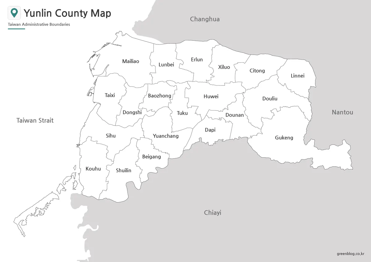
Despite its existing title, the third image is more accurately described as an unlabeled administrative map than a simple county outline. All 20 internal division boundaries remain visible. What disappears are the names of the divisions, the labels for Changhua, Nantou, Chiayi, and the Taiwan Strait, and the color fills. The title and small subtitle remain at the upper left.
That structure makes the blank Yunlin County map suitable for identification exercises. Learners can add all 20 names, group the one city and five urban townships, shade the four coastal divisions, or mark Douliu as the county seat after checking an authoritative source. Editors can also use separate colors to represent verified statistics, provided every class is defined in a legend and the data share the same reference date.
The file is a raster image rather than a confirmed vector source, so complex boundary editing may require tracing or another suitable geographic dataset. Keep a clean copy before adding labels. When preparing an accessible worksheet or presentation, supply descriptive alternative text that explains the exercise or added data rather than using only the words “blank map.”
Practical Uses for This Map
A three-stage lesson can use the files as orientation, reference, and recall materials. First, display the color image and ask learners to identify the coast, the neighboring counties, and the eastern side. Next, provide the monochrome version while students organize the 20 names by location. Finally, use the blank-label image for independent labeling or a comparison between coastal and inland divisions.
For presentations, the Yunlin County map can support a focused explanation of one part of the county instead of crowding a slide with every topic. A coastal discussion might highlight Mailiao, Taixi, Sihu, and Kouhu; an administrative overview can distinguish Douliu from the townships; and a regional comparison can retain the surrounding Changhua, Nantou, Chiayi, and Taiwan Strait context. Add roads, stations, rivers, or attractions only from current sources, since none are supplied here.
In data graphics, first confirm that the dataset uses the same 20 local divisions and consistent spellings. Assign colors according to the data rather than preserving the decorative palette, cite the reference year, and check whether the values refer to a city, urban township, rural township, village, or another geographic level. This prevents a local statistic from being attached to the wrong boundary.
Document editors should keep the Yunlin County map’s 1200 × 849 proportion and allow sufficient width for the central labels. Its wide page is suited to landscape placement, while a portrait page may require a full-width figure or a separate landscape section. Cropping excess margin is possible, but avoid removing the coastline or neighboring areas if regional orientation is important to the explanation.
Frequently Asked Questions
What is included in this Yunlin County map collection?
It includes three map styles: a color map, a black and white map, and an outline map.
Can I print the Yunlin County map?
Yes. The map files are prepared for printable use, including A3-style layout.
Is the outline map suitable for editing?
Yes. The outline version works well for adding colors, markers, routes, notes, or infographic labels.
What is the color map best for?
The color version is best for quickly comparing Yunlin County’s city, township, and rural township areas.
Can this map be used for classroom materials?
Yes. The black and white and outline versions are especially useful for worksheets, handouts, and geography projects.
Map File Information
This download contains color, black-and-white, and blank-label Yunlin County maps for administrative reference, printing, lessons, presentations, and annotation.
- Included Versions: Color labeled map, black-and-white labeled map, blank-label administrative map
- Printable Size: A3-style landscape layout
- File Type: Image files
- Intended Use: Reference sheets, labeling exercises, presentation graphics, and custom annotations
Related Maps
Additional Resources
- Yunlin County Government: Village, Township and City Offices — check the county’s official English directory and alternate romanized spellings for all 20 local administrations.
Green Map creates custom-edited map images using open geographic data sources such as geoBoundaries, Natural Earth, OpenStreetMap, and government open data. These maps are edited visual materials, not raw data files, and are provided for education, documents, presentations, and graphic reference.