A Nantou County Map immediately shows why this inland part of central Taiwan cannot be understood as a set of equal-sized districts. Ren’ai fills much of the northeast, Xinyi occupies a vast southern area, and a much tighter group of cities and townships lines the west and center. The contrast creates a distinctive tall composition rather than a compact municipal grid.
The collection includes three portrait images measuring 1200 by 1488 pixels and arranged for A3 use. One Nantou County Map separates all 13 administrative areas with muted colors, another presents the same names and lines in black and white, and the third removes all geographic text. Because the geometry remains constant, the sheets can function as reference, print, and practice versions of one map.
The labeled maps also place six surrounding names in the gray margin: Taichung, Changhua, Yunlin, Chiayi, Kaohsiung, and Hualien. They do not show roads, terrain, elevation, rivers, attraction symbols, city-point markers, or a distance scale. Sun Moon Lake and other destinations may be relevant to Nantou, but they are not named on this artwork and should be added only from a suitable source.
Table of Contents
Nantou County Map Download Overview
Nantou County is an inland county near the center of Taiwan’s main island. The map positions Taichung above it, Changhua and Yunlin along the western side, Chiayi toward the southwest, Kaohsiung below, and Hualien to the east. These names supply regional orientation even though the surrounding jurisdictions are not drawn in full.
The county government lists 13 local administrative divisions: Nantou City; Puli, Caotun, Zhushan, and Jiji; and Mingjian, Lugu, Zhongliao, Yuchi, Guoxing, Shuili, Xinyi, and Ren’ai. English romanization varies across official pages, so readers may also encounter forms such as Jhushan, Jhongliao, Yuchih, Guosing, Shueili, Sinyi, and Ren-ai. The artwork consistently uses the shorter forms printed on the images.
A practical reading route begins with Ren’ai in the northeast and Xinyi in the south, the two largest visible shapes. Puli sits west of Ren’ai, while Yuchi and Shuili lead southward toward Xinyi. Guoxing reaches north of Puli, and Zhongliao forms an interior link toward the compact western group.
On the western side, Caotun lies above Nantou City, with Mingjian below it. Jiji is a small horizontal area between Mingjian, Zhongliao, Shuili, and Lugu. Zhushan occupies the southwest, and Lugu lies between Zhushan and Shuili. This arrangement gives the Nantou County Map a dense left side and expansive right and lower sections.
What the Nantou County Map Shows
All 13 names appear in the color and monochrome versions: Guoxing, Caotun, Nantou, Zhongliao, Mingjian, Jiji, Puli, Yuchi, Shuili, Lugu, Zhushan, Ren’ai, and Xinyi. No separate dots identify town centers. A label is placed within an administrative area, so it should not be interpreted as an exact settlement location.
The maps emphasize relative shape and adjacency. Ren’ai meets Puli and Yuchi along complicated internal lines, while Xinyi adjoins Yuchi, Shuili, Lugu, and Zhushan across the southern half. The smaller western divisions require shorter labels and tighter spacing. Color separation helps with that density, but it does not represent a data category.
The outer gray field supplies context without showing complete neighboring boundaries. Taichung and Hualien sit near the broad eastern and northern sides, while four western or southern names fit around the narrower edge. The map is therefore a county-level administrative reference rather than a full central Taiwan atlas.
Color Nantou County Administrative Map
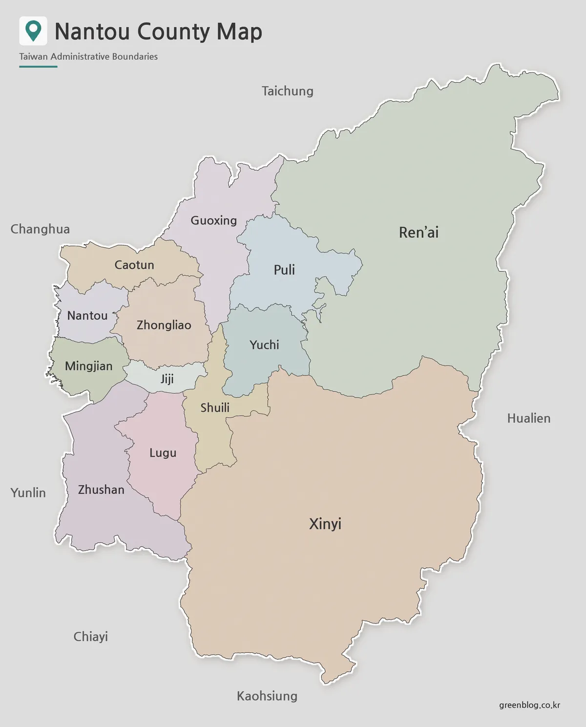
Pastel fills make the boundary network legible without overpowering the names. This is especially helpful around Nantou, Zhongliao, Mingjian, Jiji, Lugu, and Shuili, where several compact shapes meet. Ren’ai and Xinyi receive large uninterrupted fills that make their scale difference from Jiji or Nantou immediately apparent.
The Nantou County Map uses larger type for Ren’ai and Xinyi because those polygons provide more room. Labels in the western cluster are smaller but remain horizontal. The surrounding names appear outside the white county border, allowing viewers to distinguish context labels from the 13 internal administrative names.
Choose color for an introductory slide, an answer key, or a comparison in which adjacent areas must be separated quickly. The fills are not official township colors and have no legend. If a project adds population, route, tourism, or environmental information, use a separate visual system and explain it clearly.
Black and White Nantou County Map for Printing
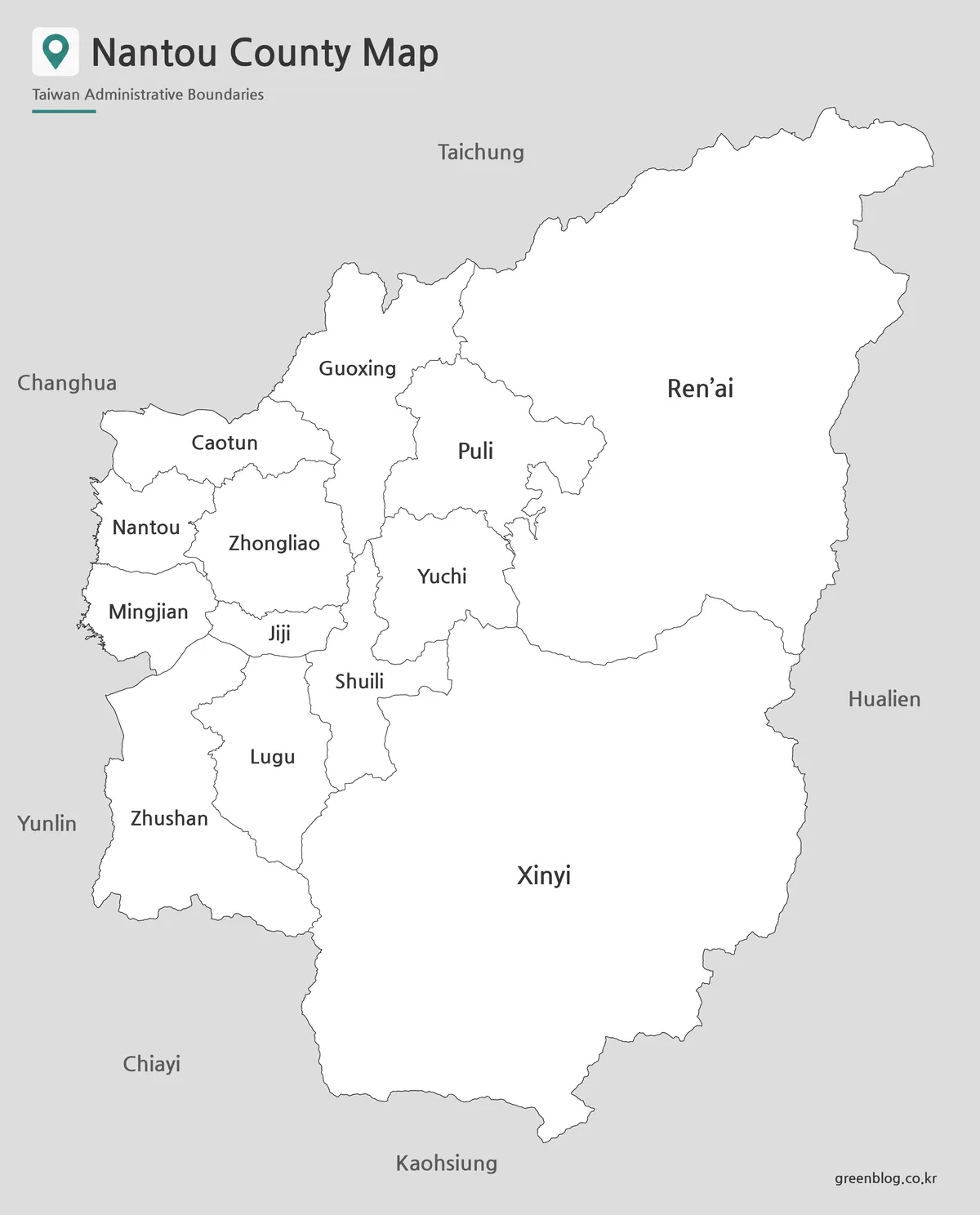
The monochrome sheet replaces the colored interiors with white while retaining the entire label set. A pale gray background separates the county from surrounding space, and thin dark lines define each administrative area. With no fill colors competing for attention, the names and unequal district sizes become the main reading cues.
This version suits grayscale reports, labeled worksheets, reference sheets, and presentation handouts. The narrow width of Jiji and the tight western cluster deserve attention during printing. Make one sample at the intended paper size and confirm that small labels and fine lines remain sharp before producing multiple copies.
The sheet is not blank: learners can see all 13 names and the six neighboring labels. It works as a checking reference beside the outline or as a base for handwritten notes that do not require erasing existing text. An activity asking students to supply every place name should begin with the third version.
Blank Nantou County Outline Map for Editing
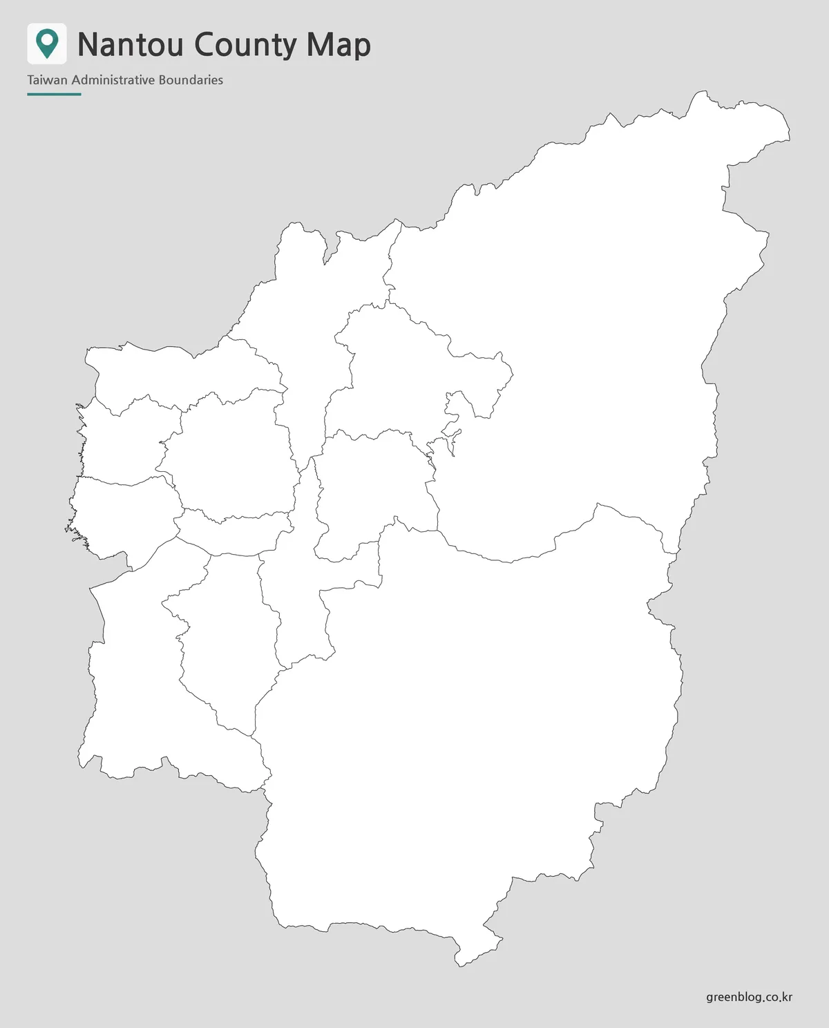
The outline removes every internal and surrounding name but preserves the county silhouette and all 13 administrative shapes. Even the title remains at the top, so the subject is identifiable while the geographic answer space stays clear. The large Ren’ai and Xinyi polygons make useful starting points when reconstructing the labeled arrangement.
A blank Nantou County Map can support a labeling exercise, a custom district grouping, or a sourced route overlay. Students might identify the two largest eastern and southern areas before completing the western cluster. Designers can add a controlled palette or symbols, but any lake, road, town center, attraction, or data value must come from another verified reference.
Retain an untouched copy before digital editing. Preserve the portrait aspect ratio, place labels where they do not cross thin district lines, and include a legend whenever added colors have meaning. The supplied preview is a raster image, so it should not be described as a vector or editable source file.
Practical Uses for the Nantou County Map Collection
For classroom sequencing, introduce the color sheet, use the black-and-white map for close name reading, and finish with the outline for recall. The repeated geometry makes completed work easy to compare with a reference. A presenter can use the same progression to move from county orientation to a project-specific overlay.
When printing the Nantou County Map at A3, choose portrait orientation and use “fit to page” rather than stretching width and height separately. Keep enough margin for the title and the surrounding names. If a smaller sheet is required, inspect Jiji, Mingjian, Shuili, and the internal western boundaries on a test copy.
The maps are also helpful for explaining the difference between county-level divisions and destination maps. Puli and Yuchi are administrative labels here, not route markers, and no symbol locates Sun Moon Lake or Cingjing. A travel graphic can use the outline as a base only after those features are placed with current, appropriate source data.
Frequently Asked Questions
The protected answers below cover printing, editing, and the number of divisions. In visual terms, the Nantou County Map shows all 13 administrative shapes, but only the color and black-and-white versions print their names and surrounding regional labels.
What is included in this Nantou County map download?
The Nantou County map download includes color, black and white, and outline versions. Each version is prepared for a different purpose, such as presentation use, printing, or editing.
Can I print the Nantou County map in A3 size?
Yes. The files are arranged for A3 layout use, which makes them suitable for larger printed materials, classroom handouts, and presentation graphics.
Is the outline version good for editing?
Yes. The blank outline map works well for adding township names, travel routes, tourism points, classroom notes, or infographic data.
How many administrative areas are shown?
The map shows 13 administrative areas in Nantou County, including Nantou City, Puli, Caotun, Zhushan, Jiji, Yuchi, Xinyi, and Ren’ai.
Map File Information
The download contains the three Nantou County administrative map views displayed on this page, each using the same 13-area boundary framework.
- Included Versions: Color labeled map, black-and-white labeled map, and blank outline map
- Printable Size: Maps arranged for A3 portrait use
- File Type: Image files
- Intended Use: County study, worksheets, presentations, reports, labeling, and sourced overlays
Additional Resources
- Nantou County Government: Organization: Check the county government’s English list of all 13 local administrative divisions and alternative romanizations.
Related Maps
Green Map creates custom-edited map images using open geographic data sources such as geoBoundaries, Natural Earth, OpenStreetMap, and government open data.
These maps are edited visual materials, not raw data files, and are provided for education, documents, presentations, and graphic reference.