Washington County occupies a sharply varied part of eastern Nebraska, with Blair serving as the county seat and Arlington, Fort Calhoun, Kennard, Herman, and Washington spread between deep creek-cut hills and the Missouri River. This Washington County Nebraska Map page combines the main road network with ranked community locations, the Missouri and Elkhorn rivers, Papillion Creek tributaries, and an elevation view that shows higher western uplands dropping quickly toward the eastern river lowlands. The WebP previews are for quick viewing, and the same four maps can be downloaded below as high-resolution JPG files in one ZIP archive. High-resolution map files are available for download in the section below.
Blair and the Missouri River are the best anchors for reading the county. Blair lies in the east-central interior and is the largest city shown, while Fort Calhoun sits farther southeast near the river. Arlington is southwest, Kennard lies between Arlington and Blair, Herman is near the northern boundary, and the small community of Washington sits close to the southern edge. This dispersed settlement pattern reflects both the road network and the deeply dissected terrain between major waterways.
Table of Contents
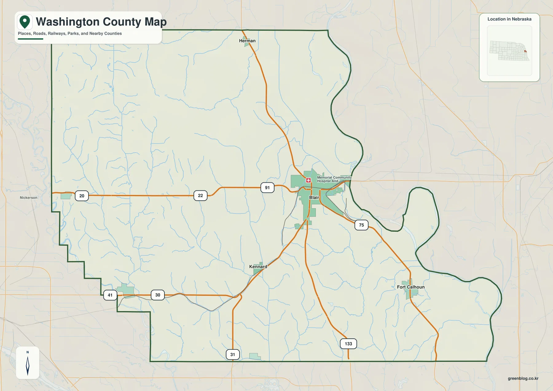
Blair where the county road network meets the Missouri River side
The general county map makes Blair the obvious transportation and service center. Nebraska 91 approaches from the west, U.S. 75 connects Blair with Fort Calhoun and the southeastern river corridor, and Nebraska 133 runs south toward the Omaha side of the region. Nebraska 31 and other roads help connect the southwestern communities around Arlington and Kennard. Together these routes give Blair the strongest concentration of road links in the county.
Herman occupies the northern edge and connects south toward Blair through the county road system. Kennard lies southwest of Blair and provides a useful reference between the county seat and Arlington. Fort Calhoun is closer to the Missouri River lowlands, while Arlington stands farther west near the county boundary. The different settings are clear even before looking at the elevation map: the eastern communities sit closer to broad river bottoms, while the western side is crossed by many narrow creek valleys.
The official county website identifies Blair as the county seat and lists Arlington, Fort Calhoun, Herman, Kennard, and Washington among the county’s towns. Blair contains county government and other major services, matching its prominent position on the supplied map. Reading town locations together with roads and stream valleys gives a better picture of the county than city names alone.
This map is a regional reference rather than a live navigation product. Construction, detours, and seasonal road conditions can change after a static image is made. Its value lies in orientation: readers can quickly see how Blair relates to Fort Calhoun and Arlington, how U.S. 75 follows the eastern side, and how Nebraska 91 and 133 connect the county seat with the western and southern road network.
Six communities from Blair to Arlington and Fort Calhoun
The ranked city map simplifies the county to Blair, Arlington, Fort Calhoun, Kennard, Herman, and Washington. Blair ranks first and is clearly the largest center. Arlington ranks second in the southwest, while Fort Calhoun ranks third in the southeast. Kennard and Herman provide smaller interior and northern reference points, and Washington appears near the southern county line.
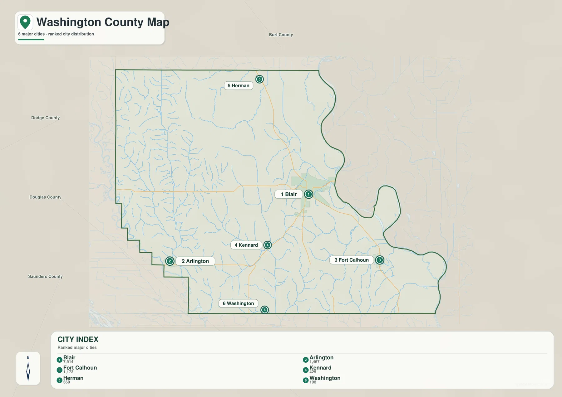
The city panel is useful for relative scale, but current population totals should come from the latest Census or local estimates when exact figures matter. The stronger geographic point is spacing. Blair and Fort Calhoun occupy the eastern half, Arlington is separated to the southwest, and Herman lies far to the north. The county therefore has several distinct community settings rather than one continuous urban strip.
Kennard sits between Blair and the southwest, while Washington is a much smaller settlement near the southern boundary. These places are easier to understand when the city map is compared with the road and elevation images. Higher ridges and creek valleys divide the western interior, while the Missouri River side opens into broader lowlands around Blair’s eastern edge and Fort Calhoun.
Missouri River bends, Elkhorn River, and the Papillion Creek system
The water map is dominated by the Missouri River, which forms the county’s winding eastern edge. Broad bends in the river create a distinctive boundary and a wide lowland around the Blair and Fort Calhoun side. The Elkhorn River appears along the southwest, giving Washington County a second major river setting that is separated from the Missouri by a broad interior of creek-cut hills.
Big Papillion Creek runs through the central part of the county, with Northwest Branch Big Papillion Creek and Southwest Branch Big Papillion Creek feeding the system from the west and south. Bell Creek, Little Bell Creek, and Brown Creek cut long valleys through the western hills. New York Creek crosses the north-central uplands, while Long Creek and Deer Creek drain the eastern and southeastern side toward the Missouri River.
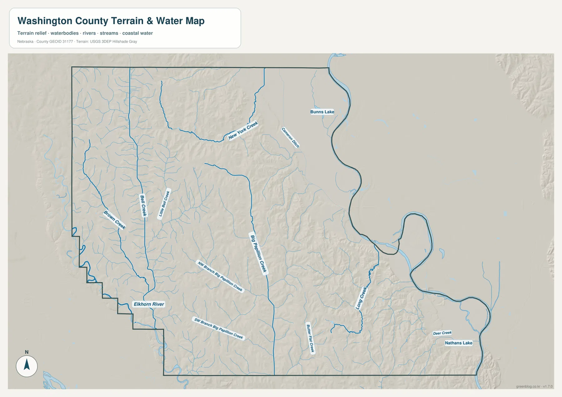
Bunns Lake appears in the northeast and Nathans Lake in the southeast. These labels help with local orientation, but the map does not provide current water level, water quality, access, fishing, or boating status. The blue line width used for streams is also symbolic and should not be treated as a measurement of discharge, depth, or flood danger.
The creek network explains much of the county’s surface form. Streams descending from the western uplands carve long narrow valleys before joining the Papillion system or turning toward the Missouri. When the water and elevation maps are compared, the named creeks generally line up with green low corridors between higher ridges.
Steep western creek hills above the Missouri River lowlands
The elevation map shows a large contrast within a relatively compact county. The displayed surface ranges from about 262 to 422 meters, with a mean near 366 meters. Brown and orange dominate the west and west-central interior, where ridges are cut by many creek valleys. Deep green covers the Missouri River side, especially inside the broad eastern bends.
Bell Creek and Brown Creek occupy long lower corridors through the western hills, while Big Papillion Creek creates another low route through the center. Numerous smaller tributaries branch into the uplands, leaving narrow ridges between them. The shaded relief therefore looks much more rugged than the general road map might suggest.
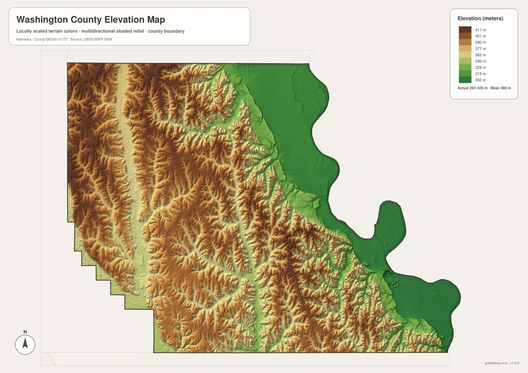
East of Blair, terrain drops toward the Missouri River and broad lowlands become more prominent. The Fort Calhoun side also sits close to this lower river country. Arlington and the western boundary, by contrast, remain surrounded by stronger relief. The short distance between steep creek hills and broad river flats is one of the county’s most distinctive physical features.
This elevation surface is intended for county-scale comparison, not parcel surveying or engineering. Exact site elevations, road grades, construction benchmarks, and design values require USGS source data, professional surveying, or another appropriate technical source. Here the image is most useful for comparing western ridges, Papillion Creek valleys, and the Missouri River lowland.
Fort Atkinson at Fort Calhoun and the shift of the county seat to Blair
Washington County’s official history says the county was organized in 1854 as one of Nebraska Territory’s original counties. The county seat moved among Fort Calhoun and DeSoto before Blair became the permanent seat in 1869. That history helps explain why both Blair and Fort Calhoun have strong civic and historical significance even though Blair is the larger modern center.
Fort Calhoun is closely associated with Fort Atkinson State Historical Park. Nebraska Game and Parks describes Fort Atkinson as one of the earliest U.S. military posts west of the Missouri River. Established in 1820 and active until 1827, it served the fur trade, river traffic, and government relations in the region. Much of the fort has been reconstructed at the modern historical park.
The fort’s location near Fort Calhoun makes geographic sense on the county maps. It stands near the Missouri River side, where lowlands meet the first rise of the interior hills. The supplied county map is not a detailed visitor map for the park, but it gives useful regional context for placing Fort Atkinson relative to Blair, Fort Calhoun, U.S. 75, and the Missouri River.
The transition from the early river-oriented Fort Calhoun area to Blair as the county seat also mirrors a broader geographic shift. Fort Calhoun is tied closely to the Missouri corridor, while Blair sits slightly inland where several roads converge. Viewing both places together helps connect the county’s early river history with its later administrative and transportation center.
A practical sequence for comparing communities, water, and relief
Begin with the general county map by locating Blair, Fort Calhoun, Arlington, Kennard, and Herman and then identifying U.S. 75, Nebraska 91, and Nebraska 133. The ranked city map provides a cleaner second view when the goal is simply to compare the six major communities and see how strongly Blair dominates the county’s settlement pattern.
Next, use the water map to trace the Missouri River, the Elkhorn River, and Big Papillion Creek. The elevation image then shows why the Missouri side becomes a broad lowland while the western interior is cut into ridges and valleys. This pairing is especially useful around Blair and Fort Calhoun, where river flats and higher ground meet over a short distance.
High-resolution JPG files are better suited to printing and close inspection when smaller creek names and route numbers matter. These maps remain regional references rather than legal or safety documents. County boundaries can be checked against Census TIGER/Line data, waterways against USGS National Hydrography, and elevation against the USGS 3D Elevation Program.
Frequently Asked Questions
Which map is easiest for comparing Blair, Fort Calhoun, and Arlington?
The ranked city map is the simplest choice because it removes most road detail. Blair is in the east-central part of the county, Fort Calhoun is southeast near the Missouri River, and Arlington is southwest. Use the general county map when U.S. 75, Nebraska 91, Nebraska 133, and smaller communities also matter.
Where are the Missouri and Elkhorn rivers in Washington County?
The Missouri River forms the winding eastern boundary, while the Elkhorn River appears along the southwestern side. Big Papillion Creek and several branches cross the interior between the two major river systems.
Does the county map show Fort Atkinson?
The general map provides the Fort Calhoun location and regional setting needed to place Fort Atkinson in southeastern Washington County. It does not show the park’s internal buildings or trails, so current visitor information should come from Nebraska Game and Parks.
Map File Information
Download the four high-resolution JPG maps shown on this page for Washington County in one ZIP archive.
- Included Files: Use only the versions confirmed in the article and supplied images
- File Type: Use the confirmed download contents
- Intended Use: Printing, education, presentations, and map-based projects
Related Maps
Sources and references
County-seat history, town listings, and Washington County background come from the official county website. Fort Atkinson history comes from Nebraska Game and Parks, while the federal sources below provide authoritative references for boundaries, hydrography, and elevation.
- Washington County – About
- Nebraska Game and Parks – Fort Atkinson
- U.S. Census Bureau – TIGER/Line Shapefiles
- USGS – National Hydrography
- USGS – 3D Elevation Program
Green Map creates custom-edited map images using open geographic data sources such as geoBoundaries, Natural Earth, OpenStreetMap, and government open data. These maps are edited visual materials, not raw data files, and are provided for education, documents, presentations, and graphic reference.