Haskell County lies in southwestern Kansas, where Sublette and Satanta provide the clearest anchors for understanding roads, settlement, drainage, and the broad High Plains surface. Sublette is the county seat and largest city, while Satanta is the second major community to the southwest. U.S. 83 runs north and south through Sublette, and U.S. 56 connects the Satanta–Sublette corridor. High-resolution JPG versions of the maps shown on this page can be downloaded together from the ZIP box below. High-resolution map files are available for download in the section below.
The county is mostly open High Plains, but the terrain is not completely flat. The Cimarron River clips the southwestern corner, Crooked Creek cuts a longer valley across the eastern side, and smaller streams branch through the north and east. Wild Horse Lake and Ellsaesser Pond provide additional water references. The elevation surface ranges from about 838 to 944 meters with a mean near 891 meters, showing higher western ground and a gradual decline toward the east.
The Kansas Historical Society records that Haskell County was established and organized in 1887. Santa Fe was the first county seat, but when the railroad arrived in 1911 it bypassed that settlement. Buildings and residents shifted toward two new railroad communities that became Sublette and Satanta, and Sublette eventually became the county seat. The simple two-city pattern on the modern map reflects that history unusually well.
Table of Contents
Sublette and U.S. 83 as the main orientation point
Sublette is the strongest reference on the general county map. U.S. 83 runs north and south through the community, while U.S. 56 approaches from the Satanta side and continues through the central-southern transportation corridor. K-190 also provides an east-west connection between the Satanta area and U.S. 83.
Satanta lies southwest of Sublette and serves as the county’s second urban center. Between the two towns and across the northern half, long straight rural roads form a pronounced agricultural grid. Tice appears as a small eastern reference, and Copeland is labeled beyond the county line in Gray County, helping place Haskell County within the surrounding region.
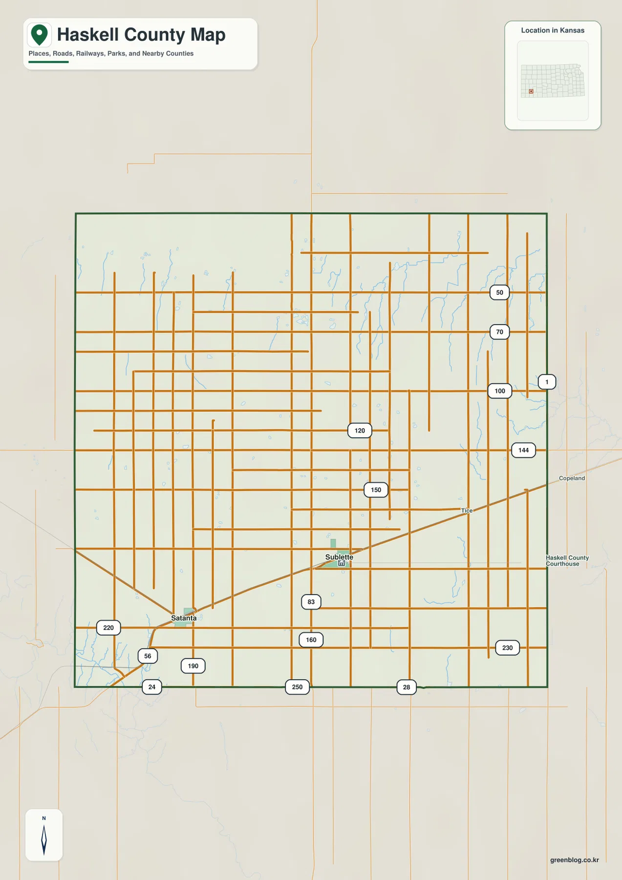
The northern half contains few settlement labels, but numerous small drainage lines break up the otherwise regular road pattern. Western Haskell County is generally higher and smoother, while the eastern side is more dissected by creeks. This map is intended for county-scale orientation rather than live navigation, so current construction, unpaved-road conditions, wind, and winter weather should be checked separately.
A two-city pattern centered on Sublette and Satanta
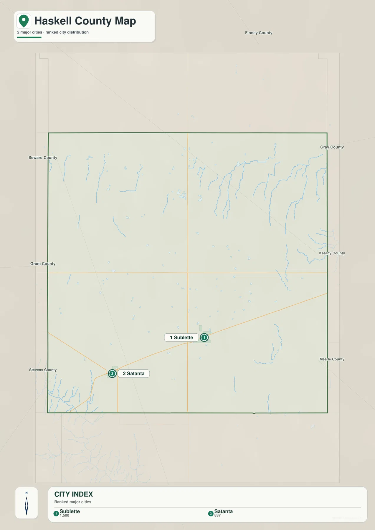
The city distribution map ranks Sublette first and Satanta second. The displayed values are 1,500 for Sublette and 837 for Satanta, figures tied to the source used to create the map rather than a permanent population count. The geographic pattern matters more: these two towns contain nearly all of the county’s visible urban concentration.
Sublette anchors the U.S. 83 corridor and county administration, while Satanta provides the main reference for the southwestern side along U.S. 56 and K-190. Large agricultural spaces separate the communities from the county boundaries, and there is no chain of similarly sized towns filling the interior.
The Kansas Historical Society explains why the two-town pattern developed. The original county seat of Santa Fe was not directly served when the railroad crossed Haskell County in 1911, and much of the settlement shifted to the two new sites. Sublette and Satanta therefore represent both present-day community geography and a major change in early twentieth-century transportation.
Cimarron River, Crooked Creek, and scattered High Plains water features
The terrain and water map shows the Cimarron River only in the southwestern corner. It does not cross the full county, but it creates an important lowland near the Satanta side and helps distinguish the southwest from the broad central uplands. Several short tributaries branch around the river corridor.
Crooked Creek is more prominent across eastern Haskell County. A network of smaller branches descends toward it from the north and west, creating a noticeably more dissected landscape than the high western plains. Wild Horse Lake appears in the northeastern portion, while Ellsaesser Pond provides another named water feature farther south.
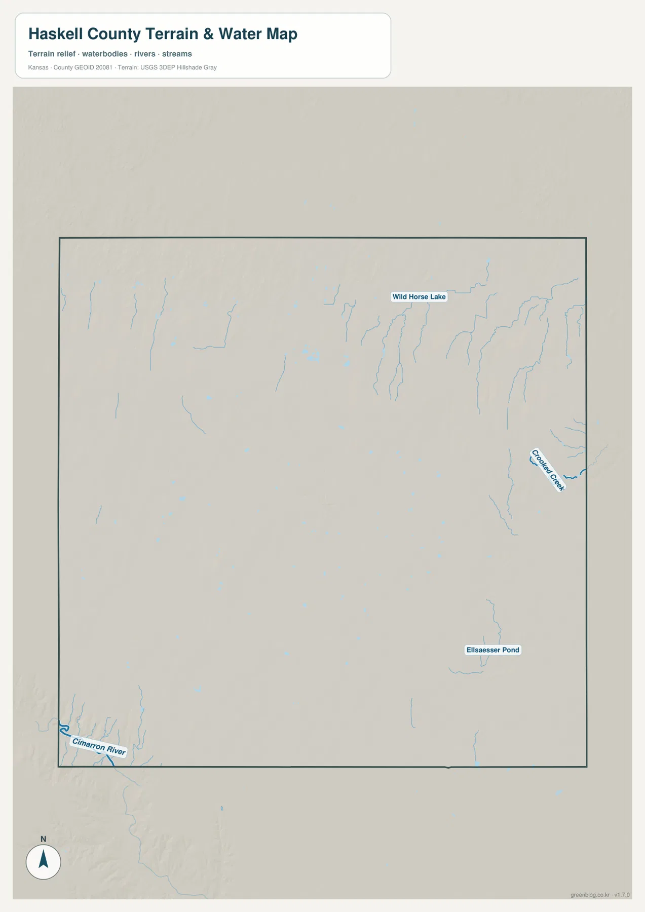
Many of the smaller High Plains channels may carry very different amounts of water depending on season and precipitation. The map is therefore a geographic reference rather than a live streamflow or flood product. Current conditions, flood warnings, and water quality should be checked through USGS or responsible local agencies when those details matter.
An 838–944 meter slope from western uplands toward the east
The elevation map shows an actual county range of approximately 838 to 944 meters and a mean elevation near 891 meters. Brown and orange colors dominate the west and northwest, while yellow-green and green become more common toward the east. The overall surface therefore slopes gently downward across the county.
Crooked Creek and its tributaries cut lower green corridors into the eastern side. The northeast is also more textured because numerous short valleys divide the upland surface. In the southwest, the Cimarron River creates a separate low area near the county corner. Western Haskell County remains broader and higher, though small drainages still interrupt the plains.
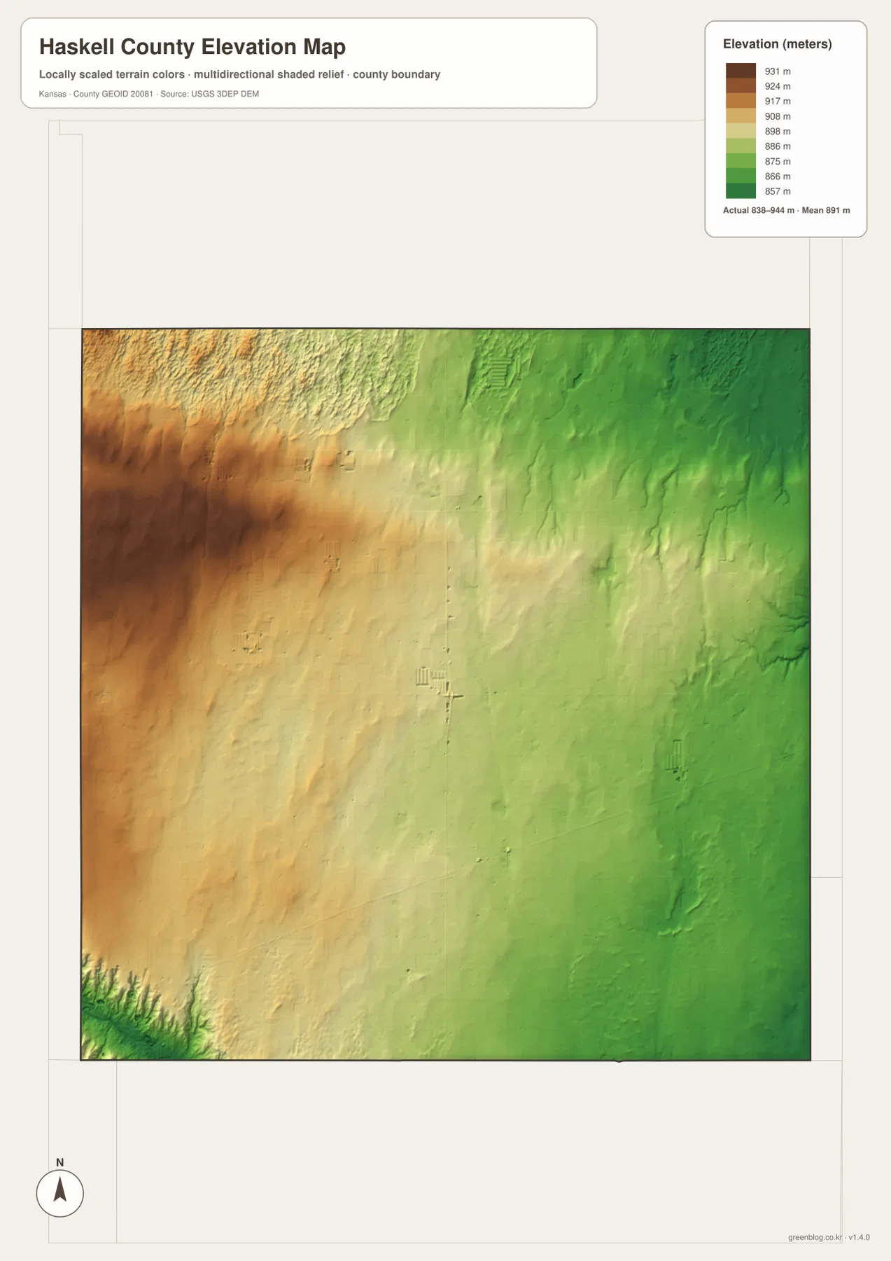
This elevation surface is intended for county-scale comparison rather than survey-grade measurement. It should not be used to establish exact parcel elevations, design drainage, or replace engineering and legal survey data. Its main value is context: from Sublette, readers can compare the higher western colors with the lower terrain around Crooked Creek in the east.
How the railroad reshaped Santa Fe into Sublette and Satanta
Haskell County’s early settlement history changed sharply with the arrival of rail service. The Kansas Historical Society notes that stage lines once connected the original county seat of Santa Fe with other small communities before the railroad reached the county. In 1911, however, the railroad route bypassed Santa Fe.
Residents and buildings shifted toward two sites along the new transportation line, producing modern Sublette and Satanta. Sublette was named for fur trapper William Sublette and became the county seat. Satanta was named for the Kiowa leader Satanta. This history explains why two communities dominate an otherwise sparsely settled county.
Agriculture and ranching remain central to the county’s identity, according to the Kansas Historical Society. The broad fields, straight rural roads, and sparse settlement shown on the maps fit that long economic pattern. Haskell County is therefore a useful example of how a High Plains landscape, railroad routing, and agricultural land use can shape a simple but distinctive settlement geography.
Using the maps for printing, study, and county orientation
For basic orientation, begin with Sublette and U.S. 83, then follow U.S. 56 toward Satanta. For physical geography, compare Crooked Creek in the east with the Cimarron River corner in the southwest and locate Wild Horse Lake farther north. The elevation map then makes the broad west-to-east slope much easier to see.
The high-resolution JPG files in the ZIP are better suited than the reduced web previews for printing, classroom projects, local-history materials, and close inspection of labels. They are useful for county overviews and regional comparison, but current roads, live stream conditions, parcel boundaries, and exact elevations should always be checked against the latest authoritative sources when those details matter.
Frequently Asked Questions
Where is Sublette on the Haskell County map?
Sublette sits in the southern-central part of the county and serves as the county seat and largest city. U.S. 83 runs north and south through the community, while U.S. 56 connects the wider corridor with Satanta to the southwest.
Where are the Cimarron River and Crooked Creek?
The Cimarron River appears only in the southwestern corner of Haskell County, while Crooked Creek forms a longer drainage across the eastern side. Both occupy terrain lower than much of the surrounding High Plains.
Can the 838–944 meter elevation map be used for surveying?
No. The elevation map is a county-scale visual reference for comparing uplands and drainage valleys. Exact parcel elevations, construction design, drainage engineering, and legal surveys require purpose-built data and professional methods appropriate to those tasks.
Map File Information
Download the high-resolution JPG files corresponding to the Haskell County general, city distribution, terrain-and-water, and elevation maps in one ZIP archive.
- Included Files: Use only the versions confirmed in the article and supplied images
- File Type: Use the confirmed download contents
- Intended Use: Printing, education, presentations, and map-based projects
Related Maps
Sources and references
- Kansas Historical Society — Haskell County, Kansas — Sublette, Santa Fe, railroad history, High Plains setting, and county background
- Kansas Historical Society — Haskell County profile — county seat, establishment, and name origin
- U.S. Census Bureau TIGER/Line — boundary, road, and geographic data resources
- USGS National Hydrography — hydrography and stream-network data information
- USGS 3D Elevation Program — elevation data information
Green Map creates custom-edited map images using open geographic data sources such as geoBoundaries, Natural Earth, OpenStreetMap, and government open data.
These maps are edited visual materials, not raw data files, and are provided for education, documents, presentations, and graphic reference.