Keith County occupies a distinctive part of western Nebraska where Ogallala sits between two major Platte River corridors and Lake McConaughy dominates the northern landscape. Interstate 80 and U.S. 30 run through the South Platte valley past Brule, Ogallala, and Paxton, while Highway 61 leads north toward Lake Ogallala, Kingsley Dam, and Lake McConaughy. This page compares the communities, major roads, North and South Platte waterways, smaller creeks and canals, and an elevation range of about 909 to 1,173 meters. The four original high-resolution JPG maps are also available in one ZIP file for printing or detailed viewing. High-resolution map files are available for download in the section below.
The county has much more relief than a simple plains outline suggests. Lake McConaughy and the North Platte River occupy a deep northern lowland, while the South Platte crosses a separate valley near I-80 in the south. Between those two corridors, short tributaries cut into rolling uplands, and the highest terrain is concentrated toward the west and northwest. Ogallala lies near the southern transportation corridor but is connected directly to the reservoir country by Highway 61, making it the easiest place to use as a reference when moving between the road, water, and elevation maps.
Table of Contents
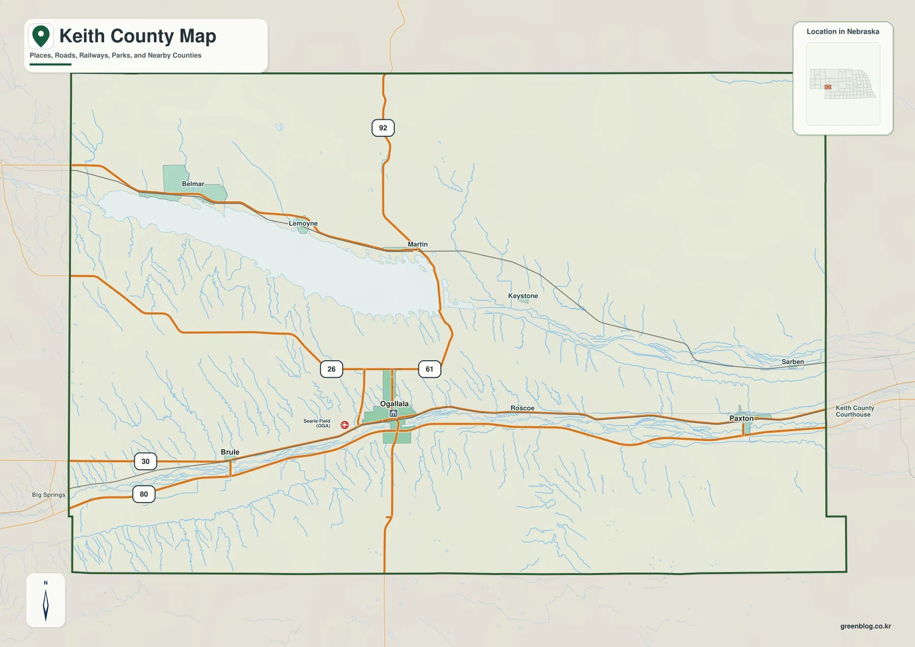
Ogallala ties I-80 and U.S. 30 to Highway 61 and the lake country
Ogallala is the most useful starting point on the general county map. I-80 runs east–west just south of the city, and U.S. 30 follows the same broad South Platte corridor through Brule, Ogallala, and Paxton. Highway 61 turns north from Ogallala toward Lake Ogallala and the eastern end of Lake McConaughy. Highway 26 heads northwest from the city toward the south side of the reservoir, while Highway 92 crosses the northern part of the county and provides another north–south reference through sparsely settled country.
Brule lies west of Ogallala in the South Platte valley, and Paxton is east along the same transportation belt. Around Lake McConaughy, smaller labels such as Belmar, Lemoyne, Martin, and Keystone help locate different parts of the reservoir shoreline. Roscoe and Sarben appear farther east near the North Platte corridor. Keith County does not have a dense network of large towns, so the lake, the two Platte rivers, and a few major roads are more useful for orientation than urban density.
The broader frame places Perkins and Garden counties to the west, Arthur County to the north, Lincoln and McPherson counties to the east, and Deuel County toward the southwest. Most outer boundaries look relatively simple, but the landscape inside them is strongly shaped by the two river valleys. Once Ogallala, Lake McConaughy, and the South Platte corridor are fixed in mind, the neighboring counties become easier to place around that structure.
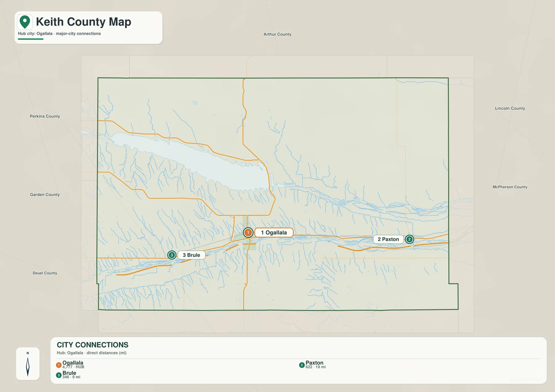
Direct distances place Brule close to Ogallala and Paxton farther east
The city-connections map uses Ogallala as its hub and gives straight-line distances to the other two ranked communities. Brule is shown about 9 miles from Ogallala, while Paxton is about 19 miles away. These are direct point-to-point measurements rather than driving distances. Actual road mileage follows I-80, U.S. 30, and local streets, so the graphic is best for comparing relative spacing and direction instead of planning a trip.
Ogallala is numbered first, Paxton second, and Brule third. The map also prints index values of 4,777 for Ogallala, 622 for Paxton, and 346 for Brule. Those numbers belong to the supplied graphic and should not be treated as a live population table; current demographic questions are better checked against recent Census data. For geographic purposes, the strong difference is clear: Ogallala is the main center, with Brule to the west and Paxton farther east along the South Platte transportation corridor.
Ogallala’s role as the hub also matches the county’s history. Keith County’s official historical account says the county was organized in 1873 and Ogallala was selected as the county seat. Today, the city still sits where I-80, U.S. 30, and Highway 61 provide access in three important directions. Brule and Paxton share the same broad river valley but serve as smaller reference points on opposite sides of the county seat.
Lake McConaughy expands the North Platte valley into the county’s largest water feature
Lake McConaughy is the dominant feature on the terrain-and-water map. The reservoir stretches from the northwestern side of Keith County toward the center, then narrows near Kingsley Dam and Lake Ogallala before the North Platte River continues east. Nebraska Game and Parks identifies Lake McConaughy as the state’s largest reservoir and manages a major state recreation area along its shores. Its size is immediately apparent on the map because it occupies a much broader area than any creek, canal, or other water body in the county.
Several named creeks descend toward the reservoir from the surrounding uplands. Mall Creek, Otter Creek, and Lonergan Creek enter from the north and northwest, while Whitetail Creek and Spring Creek are labeled near the eastern end around Lake Ogallala. Numerous smaller tributaries cut into the south shore as well. These short valleys are especially obvious on the elevation map, where steep transitions separate the low reservoir surface from the higher ground on both sides.
East of the lakes, the North Platte River is accompanied by several named canals, including Sutherland Canal, Keith Lincoln Canal, and Sheridan Wilson Canal. Their straighter shapes distinguish them from the winding natural channels. The county’s historical account notes that Lake McConaughy was built as an irrigation reservoir, so the combination of river, reservoir, and canals is central not only to the physical map but also to the region’s long-term water use.
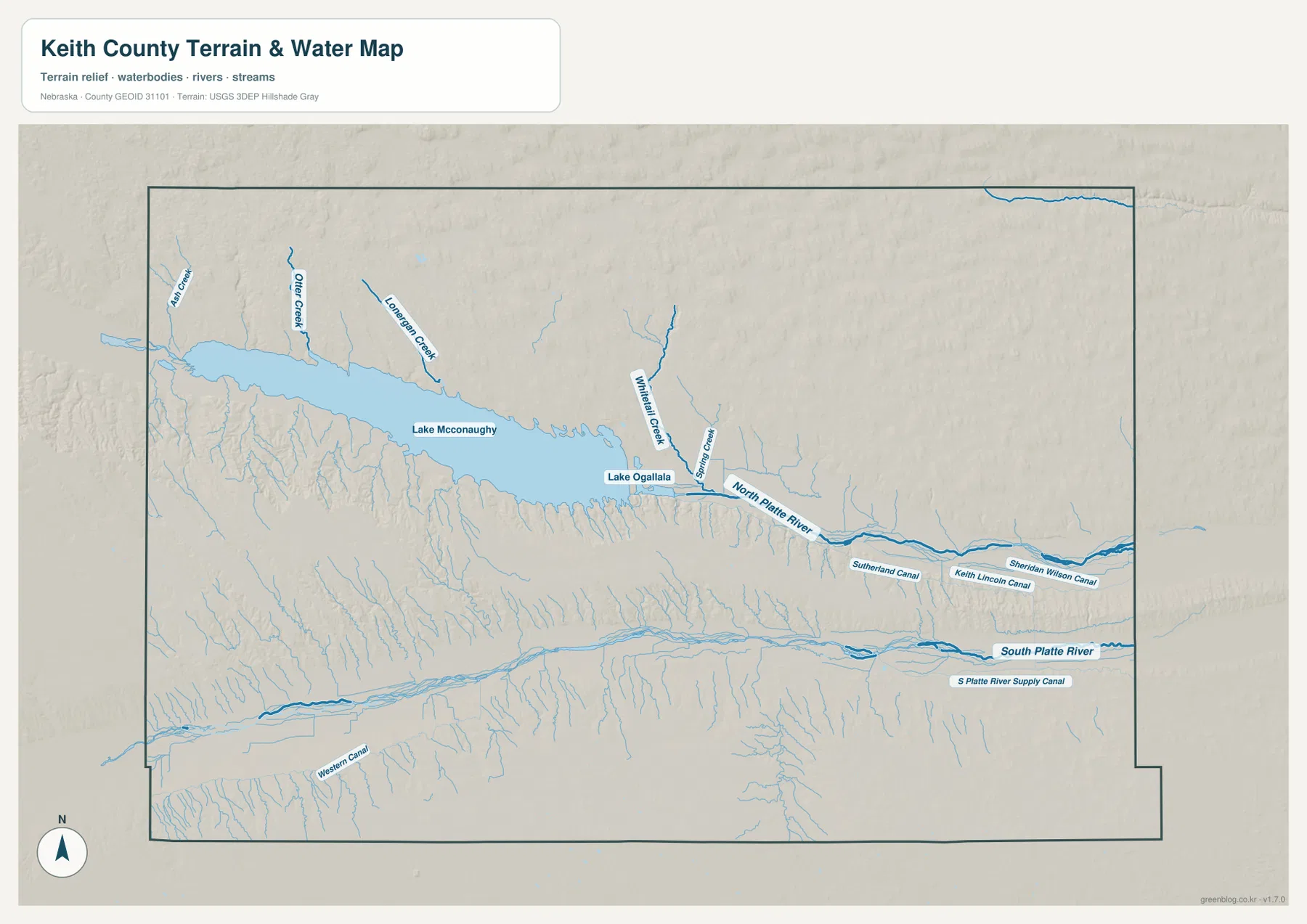
This map is intended for general geographic reference rather than real-time lake conditions, flood decisions, water rights, or boating access. Lake McConaughy’s level can change substantially, and current access conditions may differ from the static shoreline shown here. Anyone planning recreation on the reservoir should check the latest Nebraska Game and Parks notices. For county orientation, the map is most useful for showing how the reservoir, river, and tributaries divide the northern half of Keith County.
The South Platte valley carries both the river and Keith County’s main east–west roads
The South Platte River forms a second major water corridor across the southern part of the county. It enters from the west, passes near Brule and Ogallala, and continues east toward Paxton. I-80 and U.S. 30 occupy the same broad valley, though they do not follow the river channel exactly. This close relationship between water and transportation makes the South Platte lowland the most important east–west orientation feature in southern Keith County.
The river itself consists of multiple shallow channels in places, and short tributaries descend toward the valley from the north and south. Western Canal appears in the southwest, while S Platte River Supply Canal is labeled farther east. Unlike the reservoir-dominated North Platte system, the southern landscape is defined more by a broad river floor and the roads that parallel it. Comparing the two halves of the county makes the contrast clear: one is organized around a giant reservoir, the other around a transportation-rich river valley.
Keith County’s official history also emphasizes the South Platte corridor as a route of western migration, railroad development, and early settlement. Pioneers, the Pony Express, and later the transcontinental railroad moved through this valley. Ogallala then developed into a major cattle shipping point. Modern I-80 and U.S. 30 still use the same broad natural passage, so the map shows a transportation pattern with roots much older than the highways themselves.
A 909–1,173 meter elevation range highlights the reservoir bluffs and higher northwest
The elevation map gives an actual county-wide range of about 909 to 1,173 meters, with a mean near 1,026 meters. Brown and orange colors dominate the west and northwest, while lower greens become more common toward the east and within the river valleys. The roughly 264-meter difference between the mapped low and high points is substantial enough to produce steep local relief around Lake McConaughy and a clear west-to-east decline across much of the county.
The reservoir is the most dramatic example. Lake McConaughy and the North Platte valley form a long green lowland, while short gullies cut sharply into higher slopes on both the north and south shores. Southwestern parts of the lake are bordered by especially high brown and orange terrain. East of Lake Ogallala, the North Platte valley widens and becomes lower and smoother as it continues toward Lincoln County.
The South Platte valley also appears as a green band, but it is generally broader and less sharply enclosed than the reservoir corridor. Between the two rivers, long ridges and many smaller gullies create a textured central landscape. High ground also remains along the western and southwestern portions of the county. Keith County therefore cannot be summarized as a single gentle slope; it contains two major lowlands separated by extensive rolling uplands.
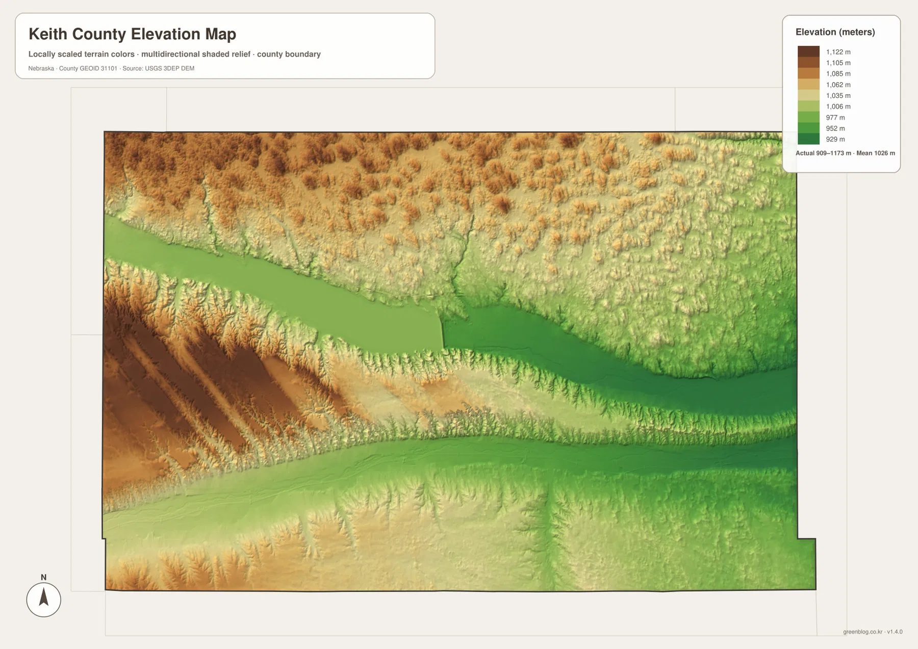
The elevation surface is generalized for county-scale comparison. It is not survey-grade information for a parcel, building site, drainage design, road grade, or engineering project. Those tasks require current detailed elevation data such as the USGS 3D Elevation Program and, when appropriate, professional field measurements. For regional study, however, the map clearly shows why the reservoir shoreline, river valleys, and western uplands feel so different despite being part of the same county.
Ogallala and Lake McConaughy connect Keith County’s transportation and water history
Keith County’s official history says the county was organized in 1873 and Ogallala became the county seat. The South Platte valley had already served as an important route for western migration, telegraph lines, railroads, and cattle movement. Ogallala grew where that corridor could support rail access and livestock shipping. On the modern map, the city remains on the same valley, now served by I-80 and U.S. 30.
Lake McConaughy added a second major focus in the twentieth century. Nebraska Game and Parks describes it as Nebraska’s largest reservoir, and today it supports recreation as well as the water-management history that led to its construction. Highway 61 provides the direct map connection between Ogallala and the reservoir’s eastern end. That arrangement gives Keith County two very different but closely linked centers: an urban and transportation hub in the south and a vast reservoir landscape to the north.
Smaller communities fill in the spaces between those two anchors. Brule and Paxton mark the South Platte corridor on either side of Ogallala, while Keystone, Lemoyne, Martin, and other small labels identify parts of the Lake McConaughy country. Reading the map through these features is more useful than memorizing the county outline alone. The two Platte rivers, Lake McConaughy, I-80, and U.S. 30 explain most of the county’s large-scale geography in a way that is easy to remember.
Choose the map by whether you need roads, settlement, water, or relief
The general county sheet is the best starting point for Ogallala, Brule, Paxton, I-80, U.S. 30, and Highways 61, 26, and 92. It keeps communities, roads, county boundaries, and Lake McConaughy in one view. The city-connections map is much simpler and is useful when the main question is how Brule and Paxton relate to Ogallala. Its mileage labels are straight-line distances, not road mileage.
For water features, the terrain-and-water map provides far more detail. Lake McConaughy, Lake Ogallala, the North Platte River, South Platte River, named creeks, and irrigation canals can all be compared on one sheet. The elevation map answers a different question by emphasizing height: it makes the higher northwest, the steep reservoir margins, and the long low river valleys immediately visible.
A practical study sequence is to locate Ogallala and the highways first, trace the lakes and rivers on the water map, and then compare the same areas on the elevation surface. The WebP images on the page are convenient previews, while the original JPG files are better for enlarging labels or printing. These are general-reference products, so legal boundaries, flood determinations, current lake levels, boating access, water rights, surveying, and engineering work should use the latest authoritative source for the specific task.
Frequently Asked Questions
Where is the Keith County seat?
Ogallala is the county seat. Keith County’s official history says the county was organized in 1873 and Ogallala was selected as the seat. It is also the most useful modern map reference because I-80, U.S. 30, and Highway 61 connect through the same area.
Are the 9-mile and 19-mile labels on the city map driving distances?
No. The map shows direct straight-line distances from Ogallala to Brule and Paxton. Driving mileage follows I-80, U.S. 30, and local roads and can be different, so current navigation information should be used for trip planning.
Are Lake McConaughy and Lake Ogallala the same lake?
No. Lake McConaughy is the large North Platte River reservoir above Kingsley Dam. Lake Ogallala is a separate, much smaller water body immediately below the dam, and the North Platte River continues east from that area. The water map labels both lakes separately.
Map File Information
The county, city-connections, terrain-and-water, and elevation maps are available together in one ZIP file. It contains four original high-resolution JPG maps suitable for detailed viewing and printing.
- Included Files: County map, city-connections map, terrain-and-water map, elevation map
- File Type: JPG files in a ZIP archive
Related Maps
Sources and references
These official and public sources provide additional context for Keith County government and history, Lake McConaughy, administrative boundaries, waterways, and elevation. The maps on this page are simplified for readable regional reference, so legal, engineering, and current-condition decisions should be checked against the original authoritative datasets and notices.
- Keith County, Nebraska official website – county government and local history
- Keith County History – county formation, Ogallala, and Platte valley history
- Nebraska Game and Parks – Lake McConaughy – reservoir and State Recreation Area information
- U.S. Census Bureau TIGER/Line – administrative boundary and geographic reference data
- USGS National Hydrography – river, lake, and canal data
- USGS 3D Elevation Program – elevation data
Green Map creates custom-edited map images using open geographic data sources such as geoBoundaries, Natural Earth, OpenStreetMap, and government open data. These maps are edited visual materials, not raw data files, and are provided for education, documents, presentations, and graphic reference.