Kearney County lies in south-central Nebraska, with Minden near the middle and smaller communities such as Axtell, Wilcox, Heartwell, and Norman spread through broad agricultural country. The Platte River system defines the northern edge, while the Little Blue River and Sand Creek drainage cut into the southern and eastern uplands. U.S. 6/34 and Nebraska Highways 10, 44, and 74 make Minden the easiest road reference. This page compares settlements, highways, waterways, and county-wide relief, and the four original high-resolution JPG map files are available together in a ZIP archive for printing or closer viewing.
Kearney County’s official planning material describes two major physical settings: the Platte River valley along the north and gently undulating loess plains across much of the southern two-thirds. The supplied elevation surface shows the same contrast. Higher brown terrain covers much of the southwest, while the north and east become progressively greener and lower. In the southeast, branching stream valleys carve the rolling surface into a denser pattern than the broad river lowland along the northern boundary.
Table of Contents
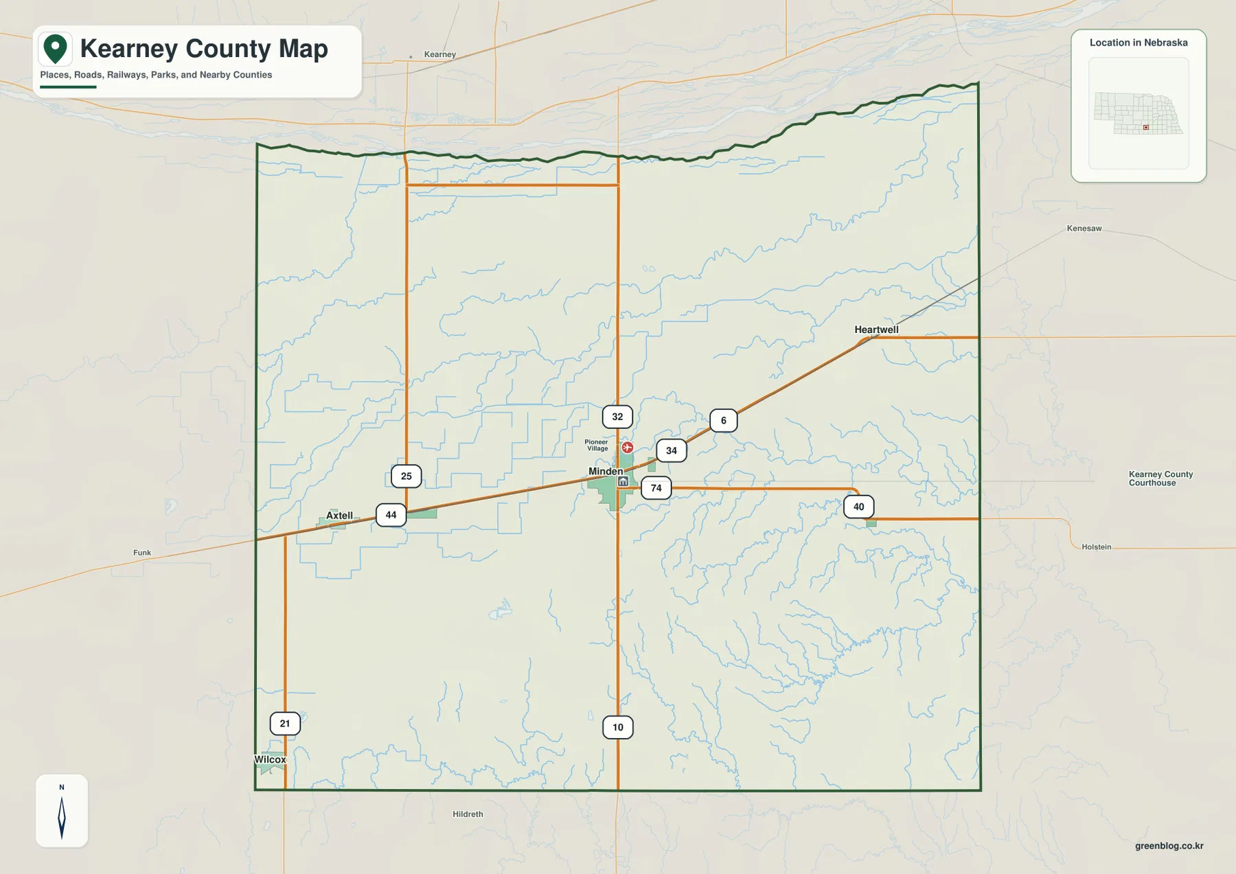
Minden organizes U.S. 6/34 and Highways 10, 44, and 74 into a simple road framework
Minden is the best place to begin on the general county map. U.S. 34 approaches from the Axtell side in the west and passes through the Minden area before continuing east. U.S. 6 angles northeast toward Heartwell, while Highway 10 runs south from Minden to the county line. Highway 74 also crosses the central part of the county from west to east. With those routes fixed in mind, the rest of the county becomes much easier to orient.
Axtell lies west of Minden near U.S. 34, while Wilcox occupies the far southwestern part of the county. Heartwell is northeast of Minden along the U.S. 6 side, and Norman lies southeast in open agricultural country. The map also labels Highways 25, 32, 40, and 44, along with many local roads. Those additional routes are useful for understanding how the smaller communities connect to the main corridor, although live construction, surface conditions, and turn-by-turn navigation require current transportation information.
The northern boundary is less geometric than the straight western and southern edges because it follows low ground near the Platte River system. Kearney and Kenesaw appear outside the county to the north and northeast, while Holstein lies east in the Adams County direction. Phelps County is west, and Franklin and Harlan counties appear farther south and southwest on the broader frame. Those surrounding labels make Kearney County’s position south of the Platte corridor much easier to remember.
Direct distances from Minden reveal a four-direction settlement pattern
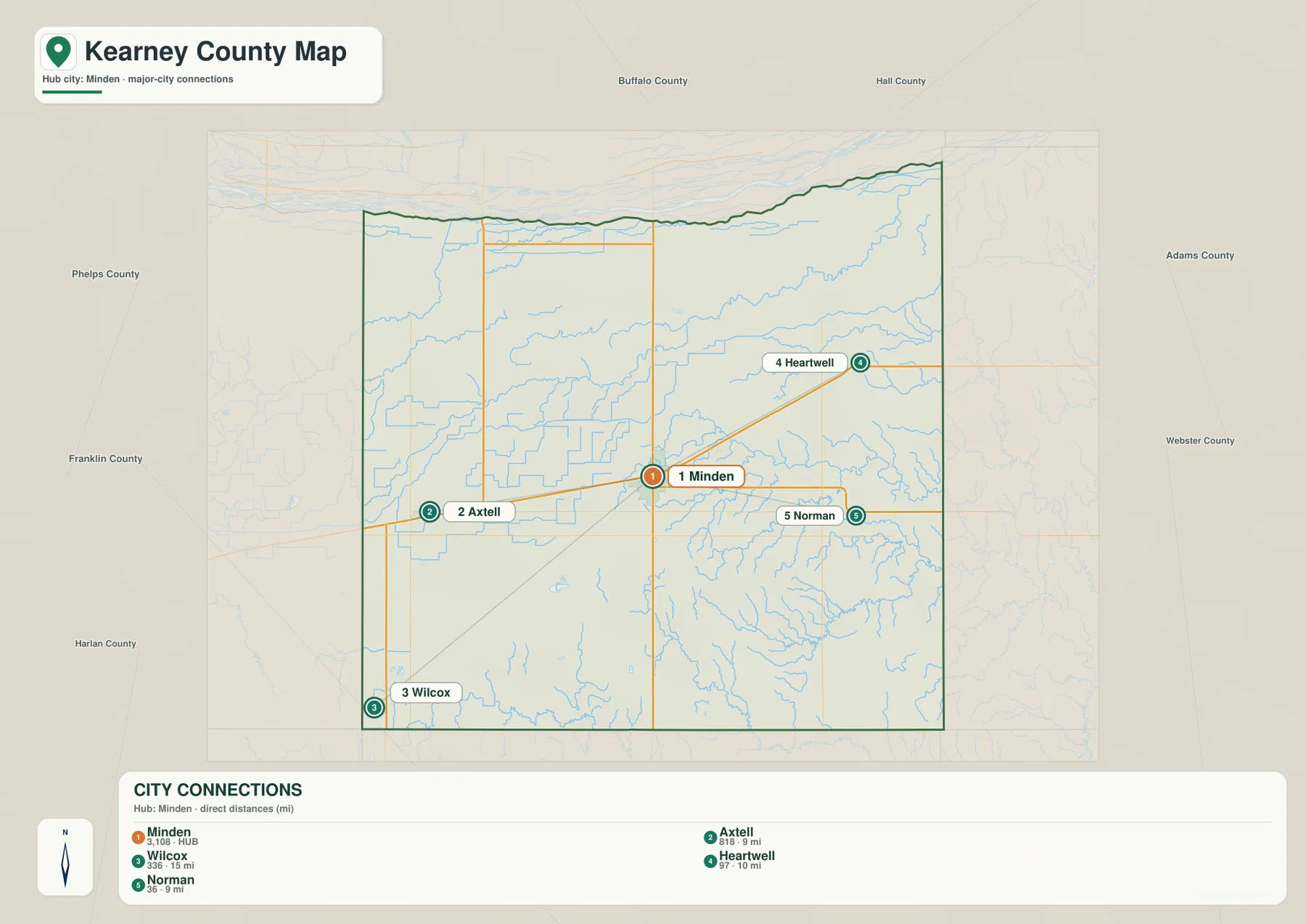
The city-connections map uses Minden as its hub and gives straight-line distances to four surrounding communities. Axtell is shown about 9 miles away, Norman also about 9 miles, Heartwell about 10 miles, and Wilcox about 15 miles from Minden. These measurements are direct point-to-point distances rather than driving mileage. The map is therefore most useful for comparing relative proximity and direction, not for estimating the length or time of a road trip.
The pattern is unusually balanced around the hub. Axtell is west of Minden, Heartwell northeast, Norman southeast, and Wilcox southwest. That arrangement spreads the labeled communities into four different parts of the county and helps explain why Minden is such a convenient central reference. On a small outline the places can appear close together, but the direct-distance values make the broad agricultural spaces between them more apparent.
The graphic also prints city index values of 3,108 for Minden, 818 for Axtell, 336 for Wilcox, 97 for Heartwell, and 36 for Norman. These values belong to the supplied map and should not be treated as a current official population table. For up-to-date demographic questions, a recent Census source is more appropriate. Geographic reading is simpler: Minden is clearly the dominant settlement and the other four places form much smaller reference points around it.
The Platte lowlands in the north contrast sharply with the Little Blue drainage in the southeast
The broadest continuous water feature is the South Channel Platte River along the northern edge of the terrain-and-water map. Whiskey Slough and smaller channels run nearby, reinforcing the impression of a wide, low river environment. Kearney County’s comprehensive plan likewise identifies the Platte River valley as the defining landscape along the northern boundary. On the elevation map, this zone appears greener and smoother than the higher interior to the southwest.
Farther south, the map combines natural streams with irrigation infrastructure. Dry Creek and North Dry Creek cross the north-central and northeastern interior, while the Adams County Canal and Phelps County Canal are labeled as long engineered waterways. Cottonwood Creek drains part of the northeast. The county’s irrigation history is unusually relevant here: Minden’s official history notes that the Kearney County Canal, conceived for power and irrigation, eventually became part of central Nebraska’s larger irrigation and public-power system.
The southern and southeastern drainage looks very different. Sand Creek cuts a prominent winding valley toward the east, and South Branch Sand Creek follows a separate lower corridor farther south. The Little Blue River appears in the south-central portion and continues toward the southern boundary, while West Branch Thompson Creek reaches the southwest edge. These streams produce a much denser pattern of branching valleys than the wide Platte lowland to the north.
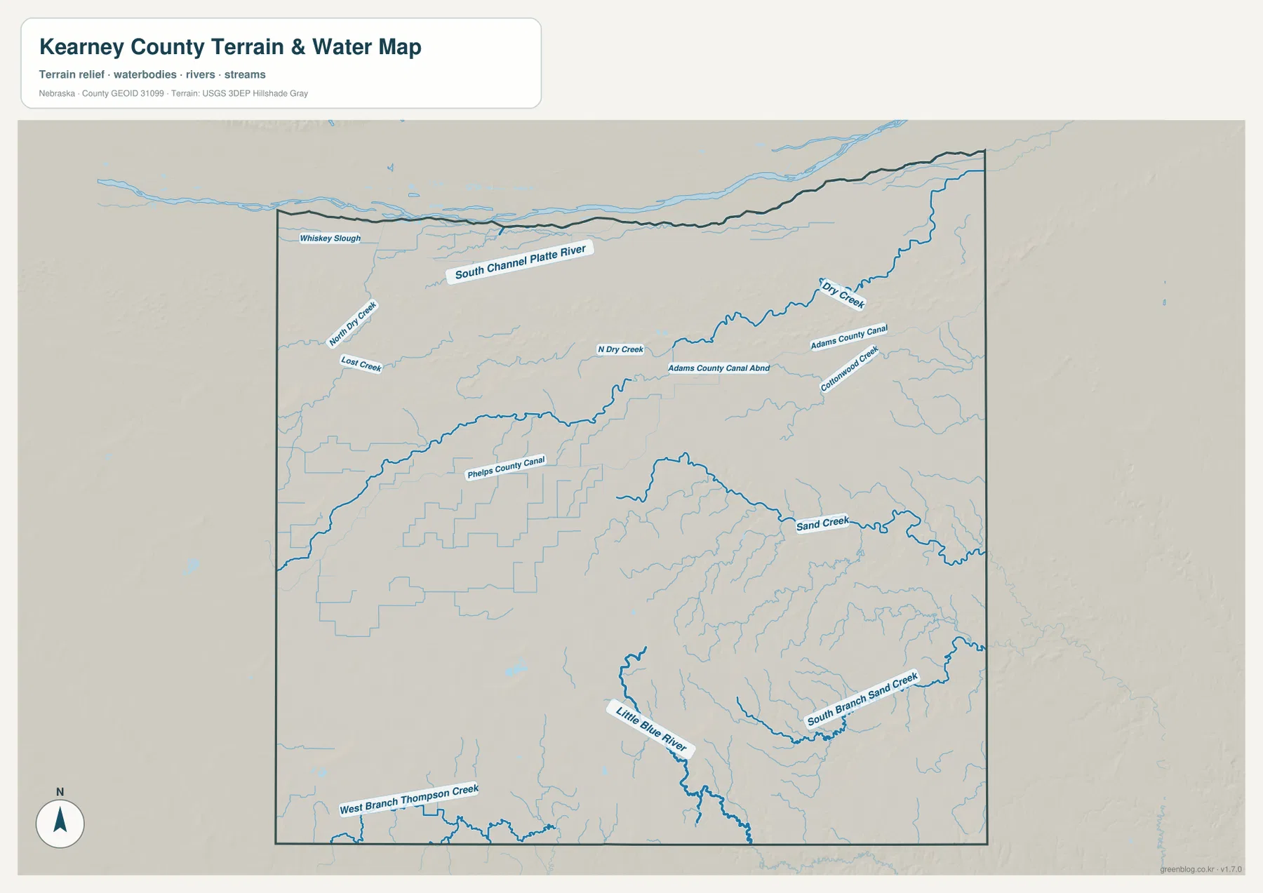
This water layer is intended for general geographic reference. It is not a flood map, legal water-rights map, parcel boundary product, or real-time stream and canal status display. Natural channels and engineered canals appear together, so current access or operational questions should be checked with the responsible agency. For county orientation, the useful distinction is between the wide northern Platte setting and the more deeply dissected southern and eastern drainage.
Elevation drops from 697-meter southwestern uplands toward lower northern and eastern corridors
The supplied elevation map gives an actual Kearney County range of about 608 to 697 meters, with a mean near 653 meters. The highest brown and orange terrain occupies much of the southwest and west-central interior. Northward and eastward, the colors shift through yellow-green to darker green. The county-wide difference is only about 89 meters, yet that is enough to distinguish the higher loess uplands from the lower Platte corridor and stream valleys.
The northern river zone is broad and comparatively smooth. Low green terrain follows the Platte side of the county, becoming especially obvious toward the northeast. South of that zone, the surface rises gradually into rolling agricultural uplands. The southwest around the Wilcox side contains some of the highest colors, matching the comprehensive plan’s description of undulating loess plains across much of the county interior.
The southeast has a different type of relief. Sand Creek and South Branch Sand Creek carve narrow green valleys into the broader surface, creating a branching pattern that is easy to match with the water map. The Little Blue River corridor is also lower than the surrounding uplands. These valleys show that the county does not simply slope in one smooth direction; the general west-to-east and south-to-north decline is repeatedly interrupted by local drainage cuts.
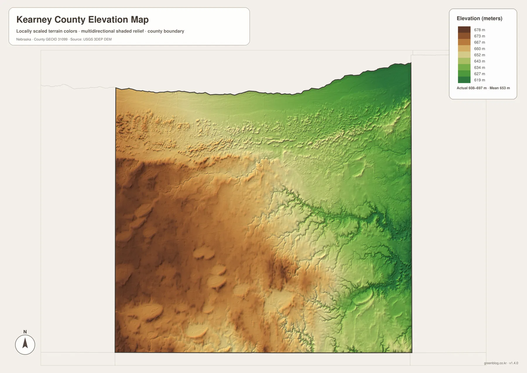
The elevation surface is generalized for county-scale comparison. It should not be used as survey-grade information for a parcel, building site, drainage design, road grade, or engineering project. Those tasks require current detailed elevation data such as the USGS 3D Elevation Program and, where necessary, professional measurements. For regional study, the 608–697 meter range makes the county’s broad north–south and west–east terrain differences easy to see.
Minden sits between the Platte corridor and the loess uplands that shaped county settlement
Kearney County’s planning documents describe a geographic split between the Platte River valley and the loess plains covering much of the southern interior. Minden lies close to the transition between those environments. From the city, major roads reach the flatter northern river country as well as the higher agricultural land to the south and west. This helps explain why Minden works so well as both an administrative center and a practical map reference.
The city’s official history adds a useful settlement story. Early population in Kearney County was concentrated near the Platte River and the Oregon Trail, but farming later expanded south across the divide. In 1876 voters moved the county seat from Lowell in the northeast to the more centrally located site that became Minden. On the modern map, the result is easy to appreciate: Minden lies near the center of the county and connects naturally to Axtell, Heartwell, Wilcox, and the surrounding road network.
The county also highlights several places and projects tied to that transportation and irrigation history. Pioneer Village in Minden preserves a large collection of historic buildings and artifacts, while the county’s official overview points to Fort Kearny State Park and the Kearney County Canal as notable parts of local history. These references fit the maps well because the county developed between a major Platte River travel corridor and an irrigated agricultural interior.
Choose the map according to whether the question is about roads, settlement, water, or relief
The general county sheet is the best starting point for Minden, Axtell, Wilcox, Heartwell, U.S. 6/34, and Highways 10, 44, and 74. It keeps roads, communities, the county boundary, and nearby place names together. The city-connections map simplifies the same geography and is more useful when the question is how far Axtell, Norman, Heartwell, and Wilcox lie from Minden in direct distance. Driving mileage still needs a current navigation source.
For physical geography, the terrain-and-water map provides the most named detail. It includes the South Channel Platte River, Sand Creek, Little Blue River, Dry Creek, Cottonwood Creek, and several canals. The elevation map removes much of that labeling and emphasizes height instead, making the high southwest and lower north and east easy to compare. Placing the water and elevation sheets side by side shows how the green lowlands closely follow the major channels.
A useful study sequence is to locate Minden and the principal roads first, trace the same areas on the water map, and then compare them with the elevation surface. The WebP images on the page are convenient previews, while the original JPG files are better for enlarging labels or printing. These are general-reference maps, so legal boundaries, flood decisions, water rights, live road conditions, surveying, and engineering work should use the latest authoritative source for the specific task.
Frequently Asked Questions
Where is the Kearney County seat?
Minden is the county seat. Kearney County’s official website identifies it as the government center, and the road map shows why it is an effective geographic reference: U.S. 6/34 and Highways 10 and 74 connect through the central part of the county. Minden’s official history says the county seat moved there from Lowell in 1876.
Are the 9–15 mile labels from Minden driving distances?
No. The city-connections map uses straight-line distances from Minden to Axtell, Norman, Heartwell, and Wilcox. Actual road mileage can be longer because travel follows the highway and local-road network, so current navigation information should be used for trip planning.
Why do the northern and southeastern water patterns look so different?
The north is part of the broad Platte River valley, where river channels and canals extend across comparatively flat low ground. The southeast contains Sand Creek, the Little Blue drainage, and many branching tributaries that cut more deeply into rolling uplands. The elevation map shows the same contrast as a broad northern lowland versus narrower green valleys in the southeast.
Map File Information
The county, city-connections, terrain-and-water, and elevation maps are available together in one ZIP file. It contains four original high-resolution JPG maps suitable for detailed viewing and printing.
- Included Files: County map, city-connections map, terrain-and-water map, elevation map
- File Type: JPG files in a ZIP archive
Related Maps
Sources and references
These official and public sources provide additional context for Kearney County government, Minden history, local terrain, administrative boundaries, waterways, and elevation. The maps on this page are simplified for readable regional reference, so legal, engineering, and current-condition decisions should be checked against the original authoritative datasets and notices.
- Kearney County, Nebraska official website – county government and community information
- Kearney County Comprehensive Plan – Platte River valley, loess plains, road, and water context
- City of Minden – History of Minden – county-seat and local development history
- U.S. Census Bureau TIGER/Line – administrative boundary and geographic reference data
- USGS National Hydrography – river and stream data
- USGS 3D Elevation Program – elevation data
Green Map creates custom-edited map images using open geographic data sources such as geoBoundaries, Natural Earth, OpenStreetMap, and government open data. These maps are edited visual materials, not raw data files, and are provided for education, documents, presentations, and graphic reference.