Download the high-resolution A3 JPG Scott County Illinois Map ZIP directly from this page. Winchester is the main central reference, while Bluffs and Naples lie in the northwest and Alsey, Glasgow, and Manchester spread across the south. The supplied maps show numbered roads, small settlements, Mauvaise Terre Creek and several other named streams, plus a strong elevation contrast between the low western side and the higher eastern and southeastern hills.
The browser-sized WebP images are convenient for quick reading, while the original JPG files are better for enlarging creek names, road numbers, and small place labels. A practical way to begin is to find Winchester and Route 100, then move north toward Bluffs and Naples and south toward Alsey, Glasgow, and Manchester. After those settlement positions are clear, the water and elevation views explain why the western edge looks broad and low while the eastern half is cut by many narrow valleys and ridges.
Table of Contents
Winchester links the northern and southern parts of the county
Winchester is the easiest place to locate on the general county map. It sits slightly south of the center and is crossed by Route 100, which enters from the west and continues eastward. Route 106 runs south from the Winchester area toward Alsey, while Manchester lies near the southeastern corner close to Routes 67 and 267. Because Winchester is also the county seat, it works naturally as the starting point for understanding both the road network and the wider settlement pattern.
The northern part has a much more dispersed arrangement. Bluffs is the strongest northwestern community, while Naples lies farther west near the county edge. Routes 36 and 72 cross the western side near Oxville before leaving the county. Exeter sits farther east in the north-central area, and Merritt and Riggston are small labels in the northeast. No continuous urban strip connects these places; instead, the map shows individual settlements separated by long stretches of rural roads and drainage channels.
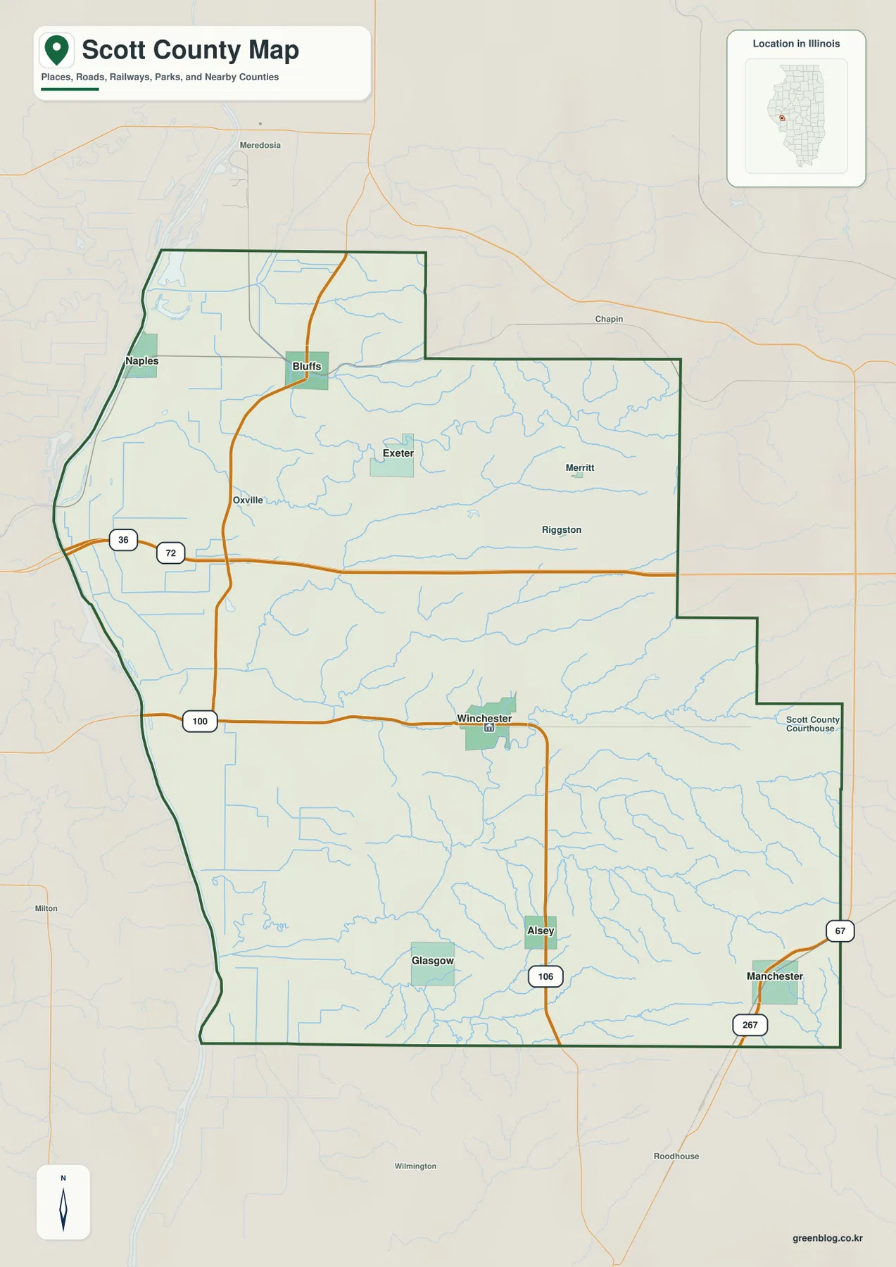
South of Winchester, the settlements are smaller and more widely spaced. Alsey lies along Route 106, Glasgow sits farther southwest, and Manchester marks the southeastern side. The map also labels the Scott County Courthouse east of the Winchester town center, providing another local reference near the middle of the county. The western boundary is comparatively long and smooth, while the eastern boundary steps inward in several places, giving Scott County an uneven outline rather than a simple rectangle.
The official Scott County website and Illinois State Archives identify Winchester as the county seat and note that Scott County was established in 1839. That history helps explain why Winchester remains the dominant map reference despite the county’s broad rural extent. For map reading, however, the most useful approach is still geographic: begin at Winchester and trace the roads toward Bluffs, Naples, Alsey, and Manchester before adding the smaller communities.
The six-place index shows how far the main settlements are spread
The city-index map removes much of the road detail and highlights six communities. Its printed ranking places Winchester first with 1,498, Bluffs second with 531, Alsey third with 258, Manchester fourth with 197, Glasgow fifth with 179, and Naples sixth with 108. These figures are treated only as values printed on the supplied map; they are not presented here as newly verified current population counts.
The positions are more informative than the numbers alone. Winchester occupies the central-southern area, Bluffs and Naples are separated in the northwest, Alsey and Glasgow lie to the south and southwest, and Manchester sits near the southeast. The six markers therefore cover a large share of the county rather than forming one compact cluster. That spread is one of the defining features of Scott County’s settlement pattern.
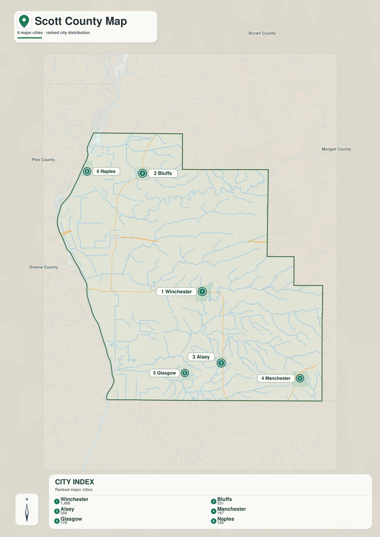
Smaller labels such as Exeter, Merritt, Riggston, and Oxville do not appear in the simplified six-place index, which is useful when the goal is to understand the main settlement pattern at a glance. Bluffs and Naples occupy the lower western side of the topographic surface, while the southern communities are closer to the dissected hill country. Comparing the city and elevation maps makes that northwestern-versus-southern contrast especially clear.
Mauvaise Terre Creek and Sandy Creek valleys cut through the hills
Mauvaise Terre Creek is one of the strongest named waterways on the terrain-and-water map. It bends across the northern-central part of the county, while Plum Creek runs farther south. Walnut Creek drains the middle-southern area, and the southern half contains Big Sandy Creek, Little Sandy Creek, and North Little Sandy Creek. Instead of one major river crossing the center of the county, Scott County is divided by several creek systems that occupy narrow valleys between higher ridges.
Near the northwest, Seamans Pond provides a clear water-body reference, with Coon Run and Eagle Run nearby. Wolf Run descends through the northern hills toward the broader Mauvaise Terre Creek drainage. In the east-central area, Big Branch and Sandy Creek are labeled around Blackburn Lake, while Brushy Fork appears farther east. These names are easier to use when the county is divided into northern, central, and southern drainage areas rather than read as one long list.
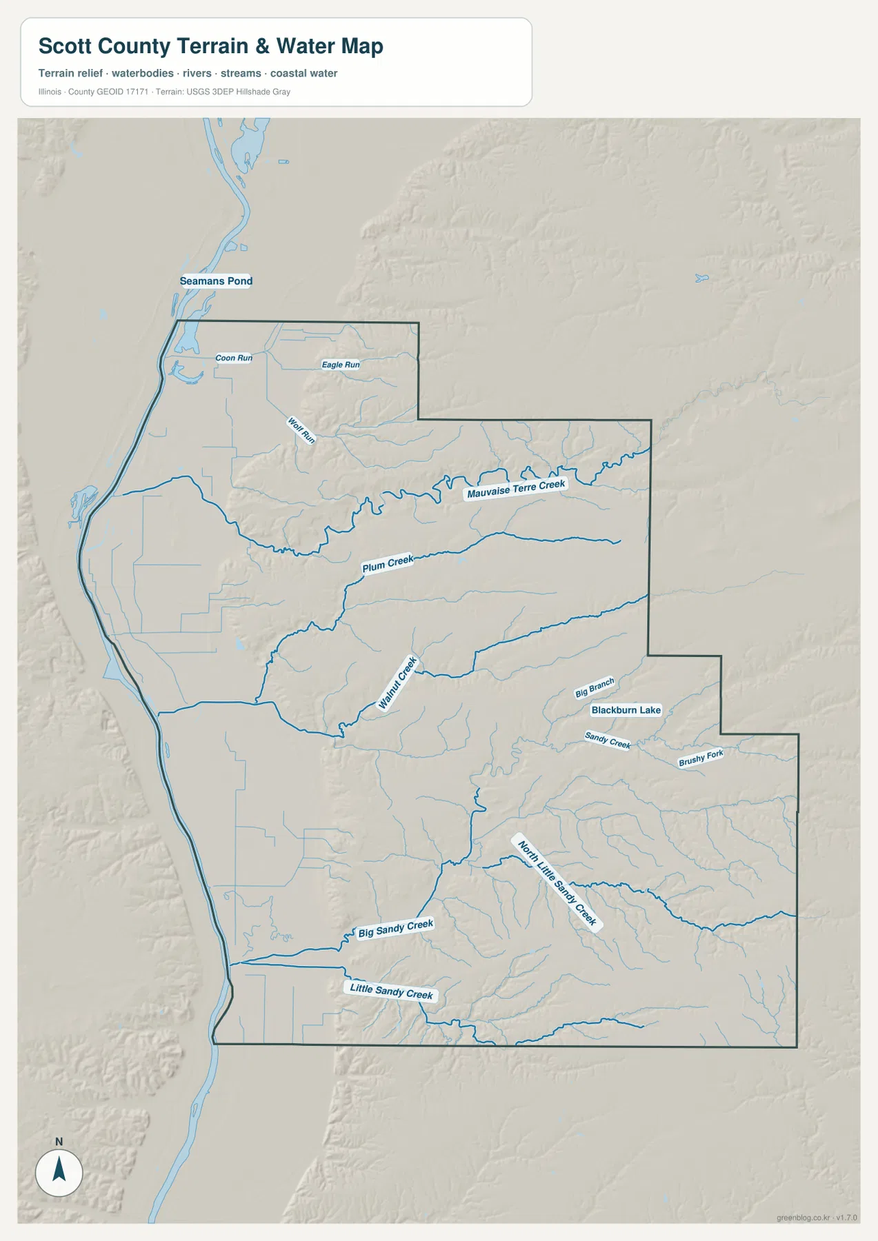
The water map also makes the broad low western side stand out from the more deeply dissected interior. Along the western edge, the terrain appears flatter and lower. Moving eastward brings more branching channels and closely spaced valleys. The southern half is especially intricate around Big Sandy Creek and North Little Sandy Creek, where many small tributaries cut into the higher terrain shown on the elevation map.
This terrain-and-water view is intended for general geographic reference. It does not establish flood risk, water quality, navigation rights, legal waterfront boundaries, or public access. Its best use is to locate named streams and small water bodies and to compare how the valleys are arranged across the county.
From 127 to 217 meters, the land rises sharply toward the southeast
The supplied elevation map reports an actual range of about 127 to 217 meters and a mean near 164 meters. The lowest dark-green terrain forms a long band along the western side, and the Naples–Bluffs area is also broadly low. Moving toward the center introduces more light green and yellow, while the eastern and especially southeastern sections contain the strongest orange and brown colors. This west-to-east rise is the clearest physical contrast on the map.
The higher southeastern terrain is not a smooth plateau. Big Sandy Creek, North Little Sandy Creek, and many smaller tributaries cut green corridors into the orange and brown surface. The same relationship appears in the north, where Mauvaise Terre Creek and Plum Creek occupy lower valleys between higher ridges. Looking at the water and elevation maps together shows why the terrain is so finely divided across the eastern half of the county.
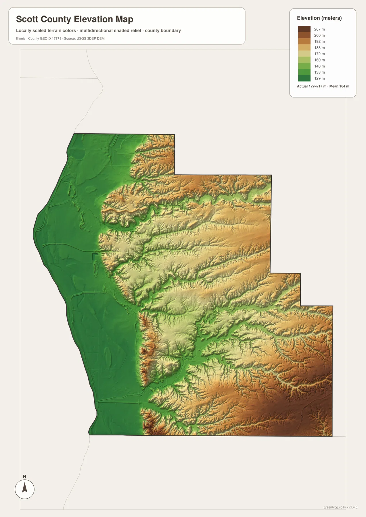
Settlement positions make the elevation contrast easier to relate to the road map. Naples and Bluffs sit close to the lower northwestern side. Winchester is near the transition between the broad western lowland and the more rolling eastern interior. Alsey and Glasgow are surrounded by a mixture of hill slopes and creek valleys, while Manchester lies close to some of the county’s strongest high-elevation colors in the southeast.
The elevation layer is designed for county-scale comparison rather than parcel surveying or engineering work. The 127–217 m range is useful for distinguishing the western lowlands, creek valleys, and higher eastern ridges, but it does not provide a survey-grade elevation at a specific address. Construction, drainage design, and legal property decisions require more precise current data.
A simple order for reading roads, streams, and relief
For communities and roads, start with Winchester and then move northwest to Bluffs and Naples and south to Alsey, Glasgow, and Manchester. The city index is useful when only the six principal settlements need to be compared. For water features, locate Mauvaise Terre Creek and Plum Creek first, then add Walnut Creek and the Big Sandy Creek system in the south. The elevation layer becomes easier to interpret once those valleys are familiar, because the lowest green corridors repeatedly follow the same drainage lines.
The ZIP below contains the original high-resolution JPG files for the road-and-boundary map, city index, terrain-and-water map, and elevation map. Each image is 2572 × 3638 pixels in portrait orientation, making small labels easier to enlarge or print than in the browser-sized WebP versions. These are general reference maps, so current traffic, legal parcel boundaries, flood determinations, water-quality rules, navigation questions, and survey-grade elevations should be checked against the appropriate official source.
Frequently Asked Questions
What is the easiest place to use as a map reference in Scott County?
Winchester is the clearest reference. It is the largest central-southern community on the map, Route 100 passes through it, and it provides a practical starting point for locating Bluffs and Naples to the northwest and Alsey, Glasgow, and Manchester to the south. The official county website also identifies Winchester as the county seat.
Which map is best for finding Mauvaise Terre Creek and the southern creeks?
The terrain-and-water map is the best choice. Mauvaise Terre Creek and Plum Creek are prominent in the northern and central sections, while Walnut Creek and the Big Sandy Creek, Little Sandy Creek, and North Little Sandy Creek system occupy the south. Blackburn Lake and Seamans Pond are also labeled.
Where is the strongest elevation contrast in Scott County?
The strongest contrast is between the low western edge and the higher eastern and southeastern hills. The supplied elevation map reports an actual range of about 127 to 217 meters and a mean near 164 meters, with the most extensive high terrain near the southeastern side.
Map File Information
The ZIP contains high-resolution A3 JPG versions of the Scott County road-and-boundary map, major-city index, terrain-and-water map, and elevation map.
- Printable Size: 2572 × 3638 pixels each
- File Type: ZIP containing 4 JPG files
Related Maps
Sources and references
- Official Scott County website – county overview and Winchester county-seat information
- Illinois State Archives – Scott County – county establishment and administrative-history reference
- U.S. Census Bureau TIGER/Line Shapefiles – county boundaries, roads, and place references
- USGS National Hydrography – rivers, streams, and lakes
- USGS 3D Elevation Program – elevation and terrain reference
Green Map creates custom-edited map images using open geographic data sources such as geoBoundaries, Natural Earth, OpenStreetMap, and government open data.
These maps are edited visual materials, not raw data files, and are provided for education, documents, presentations, and graphic reference.