Hitchcock County occupies a broad rural part of southwestern Nebraska where the Republican River forms the clearest geographic thread through the county. Stratton, Trenton, and Culbertson line up along or close to that east–west river corridor, while Palisade sits near the northern county edge. The maps on this page add roads, community connections, waterways, shaded terrain, and elevation to that basic pattern. High-resolution JPG versions of all four maps are also available together in a downloadable ZIP for printing or closer inspection.
The Republican River is a better starting point than the county boundary alone. It enters from the west, widens at Swanson Lake, passes the Trenton area, and continues toward Culbertson before leaving the county to the east. The elevation map shows the same corridor as a lower green band, while much of western and southwestern Hitchcock County rises into warmer brown and orange tones. Roads and towns tend to follow the easier valley routes, so comparing the transportation map with the water and elevation maps explains the county far better than any single layer by itself.
Table of Contents
Three river towns define the main east–west corridor
The county map places Stratton in the west, Trenton near the middle, and Culbertson in the east along a remarkably clear east–west route. U.S. 34 provides the strongest road connection among them and generally follows the same broad Republican River valley. Trenton is the county seat, and the official Hitchcock County website lists the courthouse there. Culbertson forms another important road junction toward the eastern side of the county, while Stratton marks the western community along the river corridor before the landscape opens toward Dundy County.
Nebraska Highway 25 adds the most obvious north–south route near Trenton. It crosses the Republican River, meets U.S. 34 near town, and continues north toward Palisade and Hayes County. Farther east, Nebraska Highway 17 approaches Culbertson from the south, where it connects with the U.S. 6 and U.S. 34 corridor. These junctions matter because Hitchcock County has long distances between small communities; a limited number of paved routes carry much of the through movement while local roads spread out into agricultural areas on both sides of the river.
Palisade appears near the northern edge rather than on the main Republican River line. The community lies at the Hitchcock–Hayes county boundary, so it works as a useful reminder that local settlement does not always fit neatly inside one rectangular county. The southern half of the county looks quite different. Major town symbols are scarce there, but roads and tributary valleys remain dense, showing that the absence of larger communities does not mean the landscape itself is empty or featureless.
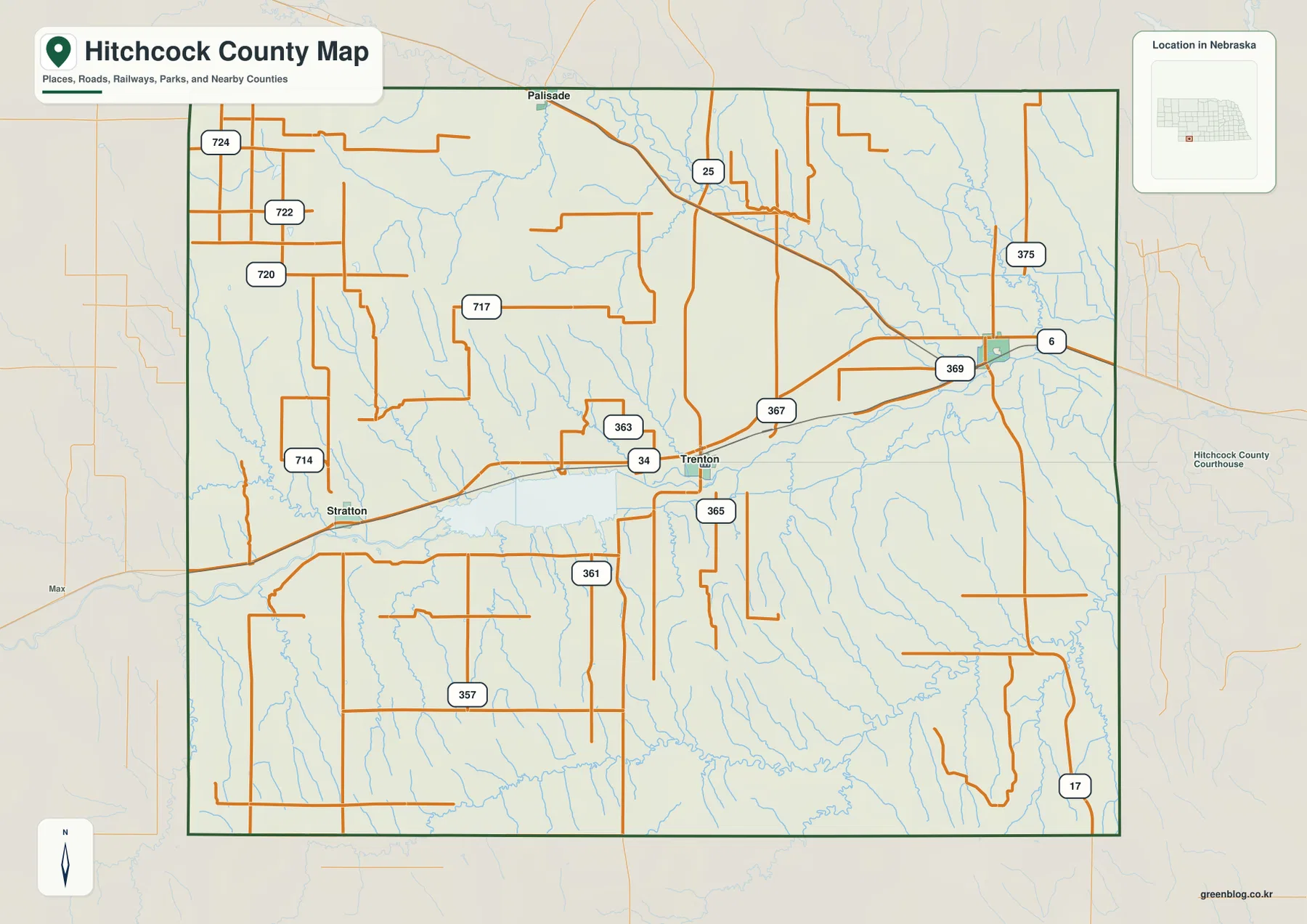
The county boundary also provides useful regional context. Dundy County is to the west, Hayes County is to the north, and Red Willow County is to the east; the Kansas state line lies to the south. That placement explains why roads from Trenton and Culbertson continue southward as well as east or west. This map is well suited to orientation and printed reference, but it is not a live navigation product. Road closures, construction, and local access can change, so current travel decisions should always be checked against up-to-date transportation information.
Culbertson gives a simple reference for the four mapped communities
The city-connections map uses Culbertson as a hub and simplifies the county to four labeled communities: Culbertson, Trenton, Stratton, and Palisade. The map lists straight-line distances of about 10 miles from Culbertson to Trenton, 16 miles to Palisade, and 21 miles to Stratton. Those figures are not driving distances, but they make the county’s settlement pattern immediately legible. Trenton lies to the west, Stratton farther west-southwest, and Palisade to the northwest near the county line.
Culbertson’s role as the mapping hub should not be confused with county government. Trenton is the county seat and remains the administrative reference point. The hub designation simply provides one common origin for measuring direction and relative spacing. That distinction is useful because Culbertson is a natural transportation reference on the eastern side, whereas Trenton is the central civic reference. Looking at both roles helps explain why no single community completely dominates the county map.
The spacing among the four places also shows why Hitchcock County feels different from a densely settled county. There is no continuous chain of built-up areas between Stratton, Trenton, and Culbertson. Instead, broad stretches of farmland, river bottom, side valleys, and local roads separate the towns. Palisade is even more detached from the east–west line because it sits near the northern edge. The simplified city map is therefore most useful for understanding direction and scale rather than for showing every road or small locality.
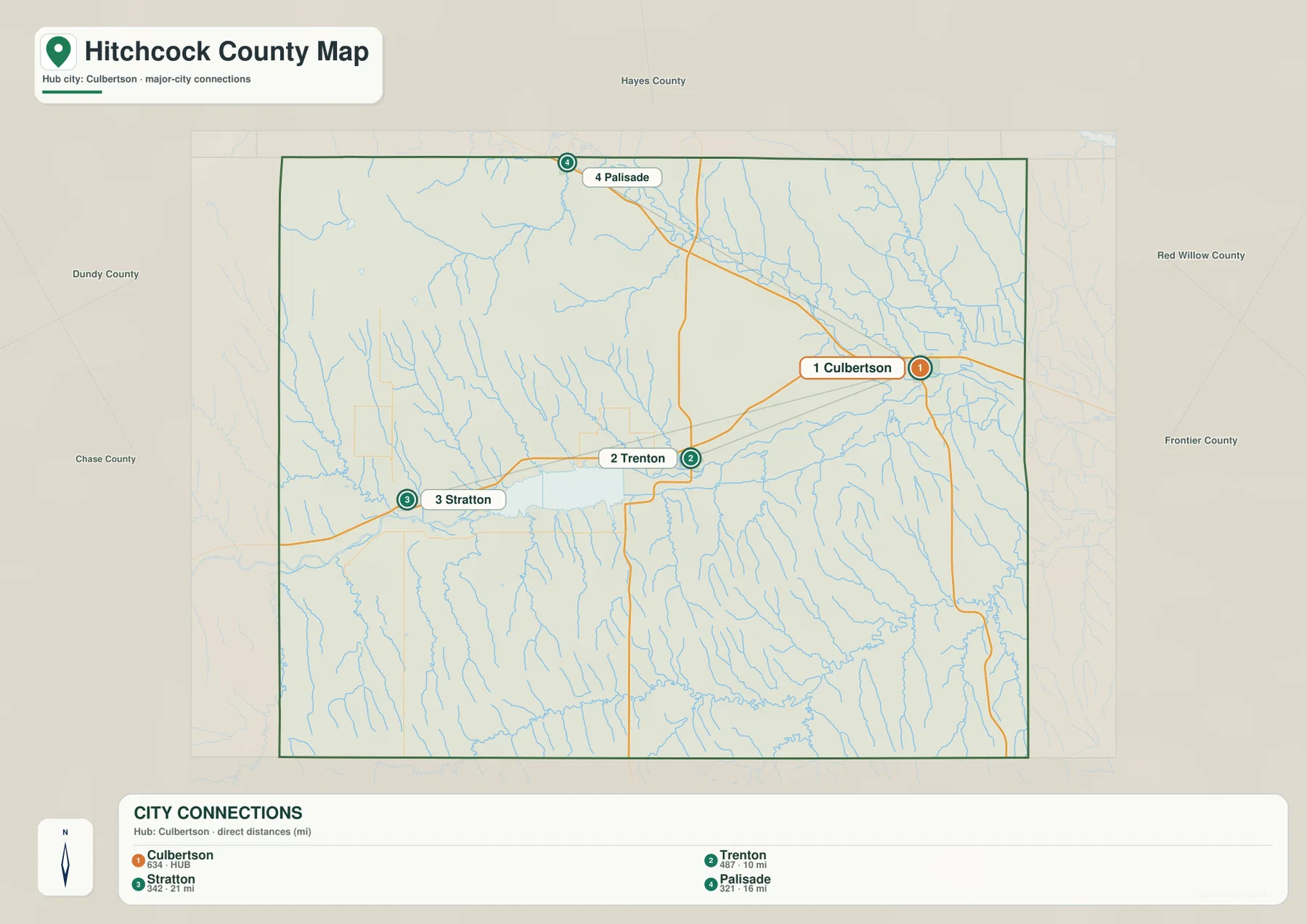
For an actual trip, the straight-line figures should be treated only as geographic reference. Driving distance depends on the available road network, bridge locations, the reservoir, and the shape of the river valley. A route that looks short on a direct line may require a longer road approach. The city-connections map is best for quickly answering where the communities sit in relation to one another; current navigation services are better for mileage and travel time.
The Republican River links Swanson Lake, Trenton, and Culbertson
The terrain-and-water map makes the county’s physical structure much clearer. The Republican River crosses Hitchcock County from west to east and forms the central drainage corridor. In the western half, the river broadens into Swanson Lake, the largest single water body shown on the map. Nebraska Game and Parks Commission manages Swanson Reservoir State Recreation Area near Trenton and describes it as a major recreation site in southwestern Nebraska. Even for readers who are not planning a visit, the reservoir is an excellent landmark because it anchors the western part of the river valley.
Several named streams join the broader Republican River system. Frenchman Creek approaches from the northwestern side and reaches the Culbertson area, while Blackwood Creek descends farther east. The map also labels the Culbertson Canal, Culbertson Canal Extension, and Upper Meeker Canal, showing that the valley contains engineered water features as well as natural streams. They are useful for understanding the local water landscape, but the map does not describe current diversions, water rights, irrigation operations, or seasonal flow conditions.
South and southeast of the main river, Driftwood Creek and its North and South forks cut a second set of noticeable valleys. Elm Creek appears near the eastern edge, and Muddy Creek approaches the Swanson Lake area from the west. These tributaries explain why the southern half of the county looks highly dissected in the shaded relief. What seems like open upland on a road map is actually broken by many branching drainage lines, especially where small creeks have cut into the higher surface.
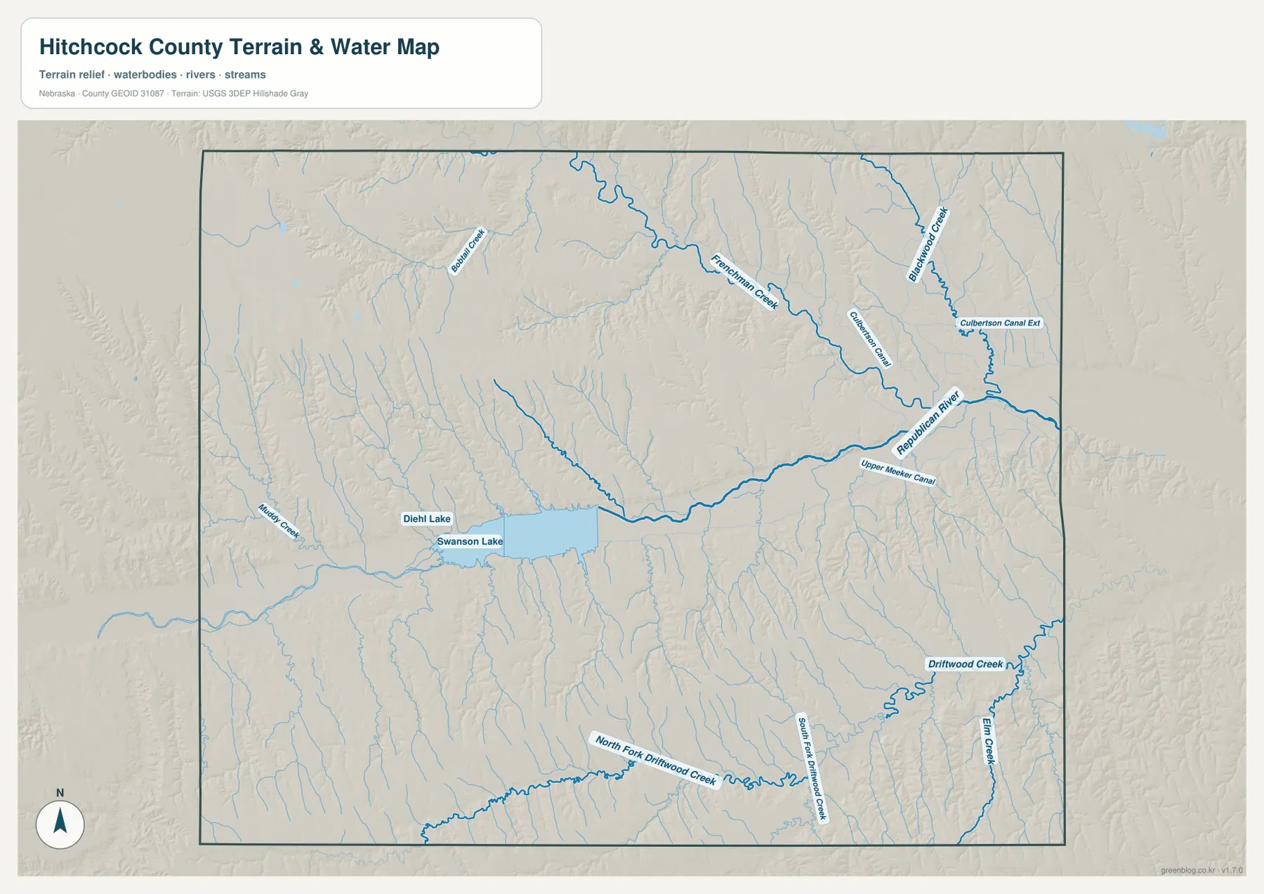
This is a reference map of water features and terrain, not a flood map, parcel map, navigation chart, or real-time water-status product. Reservoir access and boating conditions can also change with maintenance, water levels, or seasonal operations. For a current visit to Swanson Reservoir, Nebraska Game and Parks Commission notices should take priority over a static map. For geographic study, however, the combination of named waterways and shaded relief is especially useful because it shows where the valleys sit in relation to the towns and highways.
A 771–968 meter range reveals high western uplands and a lower river floor
The elevation map gives Hitchcock County an approximate mapped range from 771 to 968 meters, with a mean near 875 meters. Warm brown and orange tones dominate broad parts of the west and southwest, while the Republican River corridor appears as a long green band of lower ground. The difference between the mapped minimum and maximum is about 197 meters. That is not mountain relief, but it is enough to create a distinct contrast between the upland surfaces and the main valley.
The west is not simply one uninterrupted high plateau. Lower green channels cut through the higher colors wherever tributaries approach Swanson Lake or the Republican River. East of Trenton, the main valley remains low toward Culbertson, and branching green fingers follow smaller drainages away from the river. In the southeast, the Driftwood Creek network produces a particularly clear pattern of incised valleys. These features match the terrain-and-water map closely and show why reading the two maps together is more informative than relying on color alone.
The towns also make more sense when viewed against this relief. Trenton and Culbertson occupy the lower river corridor rather than the highest uplands, and U.S. 34 follows the same broad east–west lowland. Stratton is also tied to the Republican River valley, but higher terrain rises more strongly around the western part of the county. Palisade sits near northern tributary country, outside the main river-town chain. The map therefore connects settlement and transportation patterns with the physical shape of the land without claiming that terrain alone determined where every road or community developed.
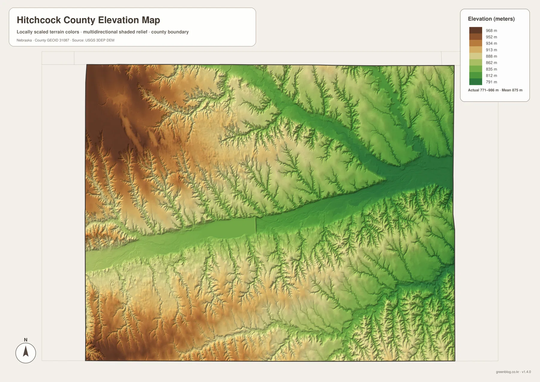
The elevation surface is generalized for county-scale comparison. It should not be treated as survey-grade elevation for a parcel, building site, drainage design, or engineering project. Anyone needing precise height information should work from current USGS 3D Elevation Program data or a professional survey. For classroom use, regional comparison, and map reading, the color ramp is valuable because it makes the county’s major relief pattern visible at a glance.
Swanson Reservoir is the easiest landmark for reading western Hitchcock County
Swanson Lake is large enough to serve as a visual anchor on both the water map and the broader county map. Nebraska Game and Parks Commission operates Swanson Reservoir State Recreation Area near Trenton and identifies it as one of the important recreation destinations in southwestern Nebraska. On the map, the reservoir occupies the Republican River valley west of Trenton, where it separates the higher uplands north and south of the valley. Finding the reservoir first makes it easier to orient Stratton to the west and Trenton to the east.
Trenton then becomes the best second reference point. It combines county government, the U.S. 34 corridor, Highway 25, and the river valley in one location. Culbertson provides a different kind of anchor at the eastern side, where the U.S. 6 and U.S. 34 corridor and north–south roads meet near additional waterways and canals. Stratton marks the western river corridor, while Palisade helps locate the northern county line. The four communities are small, but their positions reveal the county’s overall structure much more clearly than population size alone would suggest.
Natural features also continue beyond the administrative border. The Republican River enters from Dundy County and continues toward Red Willow County, while Frenchman Creek and other tributaries belong to drainage systems larger than Hitchcock County. That means county lines are essential for government and statistics but less meaningful to the movement of water or the shape of a valley. A useful map reading habit is to keep both ideas in view: use the boundary for administrative location, then follow the terrain and waterways across it to understand the wider landscape.
Choose the map that matches the question
For towns, roads, neighboring counties, and general orientation, start with the county map. It is the best single sheet for showing the U.S. 34 corridor from Stratton through Trenton to Culbertson, Highway 25 toward Palisade, and the spread of local roads across the rural landscape. If the only question is how the four labeled communities relate to one another, the city-connections map is cleaner. Its straight-line distances from Culbertson remove most background detail and make direction and spacing the focus.
Use the terrain-and-water map when the Republican River, Swanson Lake, Frenchman Creek, Driftwood Creek, or canals are the main subject. It is especially helpful for explaining why the county is divided into a broad central river corridor and many smaller side valleys. The elevation map is better for comparing the higher western and southwestern uplands with the lower river floor. Its 771–968 meter scale provides a simple way to describe where the largest relief differences occur.
For a school project or regional comparison, a good sequence is to identify the communities and roads first, then compare the water and elevation layers. U.S. 34 makes more sense when it is viewed alongside the Republican River valley, and Swanson Lake is easier to place when the surrounding higher ground is visible. The four files work well as a set because each removes some information and emphasizes something different rather than repeating the same map with cosmetic changes.
The original JPG files are preferable to the on-page WebP previews when small labels or shaded-relief details need to be enlarged or printed. You can use a single sheet for a focused task or keep all four together for comparison. These are general-reference maps, so legal boundary determination, property surveying, flood decisions, live road conditions, and engineering work should rely on the latest authoritative datasets and professional sources.
Frequently Asked Questions
Is Trenton or Culbertson the county seat?
Trenton is the county seat, and the official Hitchcock County website lists the courthouse there. Culbertson is used as the hub on the city-connections map only to provide one reference point for straight-line distance and direction to Trenton, Stratton, and Palisade.
Does Swanson Lake belong to the Republican River system?
Yes. The terrain-and-water map shows Swanson Lake along the Republican River in western Hitchcock County. The river continues eastward from the reservoir past the Trenton area toward Culbertson, while tributaries such as Frenchman Creek and the Driftwood Creek system join the wider drainage network.
Can the 771–968 meter elevation range be used for surveying or construction?
No. The elevation map is a generalized county-scale surface designed to compare broad relief, such as the higher western uplands and lower Republican River corridor. Parcel-level design, drainage, construction, or surveying should use current detailed elevation data and professional measurements.
Map File Information
The county, city-connections, terrain-and-water, and elevation maps described on this page are available together in one ZIP file. It contains four original high-resolution JPG maps suitable for printing and detailed viewing.
- Included Files: County map, city-connections map, terrain-and-water map, elevation map
- File Type: JPG files in a ZIP archive
Related Maps
Sources and references
These official sources provide additional context for Hitchcock County government, Swanson Reservoir, county geography, waterways, and elevation. The maps on this page are simplified for readable regional reference, so current facility notices and technical decisions should be checked against the original authoritative sources.
- Hitchcock County, Nebraska official website – courthouse and county government information in Trenton
- Nebraska Game and Parks Commission – Swanson Reservoir – state recreation area and reservoir information
- U.S. Census Bureau QuickFacts – Hitchcock County – county statistics and geographic reference
- U.S. Census Bureau TIGER/Line – boundary and geographic reference data
- USGS National Hydrography – waterways and hydrography reference
- USGS 3D Elevation Program – elevation data reference
Green Map creates custom-edited map images using open geographic data sources such as geoBoundaries, Natural Earth, OpenStreetMap, and government open data. These maps are edited visual materials, not raw data files, and are provided for education, documents, presentations, and graphic reference.