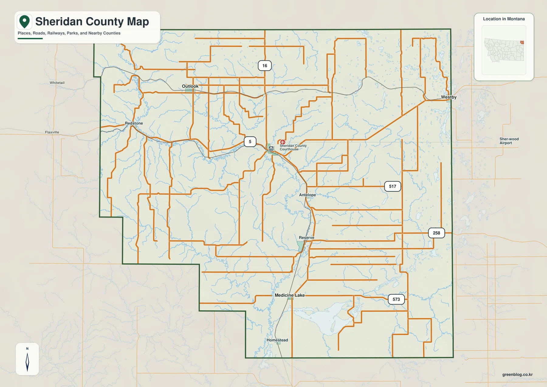
Sheridan County occupies Montana’s far northeastern corner, just south of the Canadian border, with Plentywood serving as the main settlement and road reference. Route 5 crosses the central-northern county, Route 16 runs north-south through the Plentywood area, and routes 517, 258, and 573 organize parts of the east and south. The terrain-and-water map adds Big Muddy Creek, Plentywood Creek, Antelope Creek, Wolf Creek, and Medicine Lake as useful natural landmarks across a broad prairie landscape. The elevation map shows lower creek corridors between gently higher western and north-central uplands. High-resolution JPG versions of the maps are available together in the download ZIP below.
Montana Association of Counties identifies Plentywood as the Sheridan County seat. The county’s planning page describes a joint county-city planning process centered on Plentywood, while the official area-attractions page highlights Medicine Lake National Wildlife Refuge and Medicine Lake. On the maps, Plentywood makes a practical starting point: Outlook lies to the northwest, Westby to the east, and Medicine Lake to the south.
Table of Contents
Routes 5 and 16 meet the county’s main settlement pattern
On the general county map, Plentywood sits slightly north of the county’s center and the Sheridan County Courthouse label appears in the same area. Route 5 is the clearest east-west road, approaching from Redstone and continuing toward the eastern side. Route 16 provides the long north-south reference through the Plentywood area and toward Reserve and Medicine Lake.
Outlook lies northwest of Plentywood, while Westby is close to the eastern boundary. The road network becomes dense across the northern and eastern agricultural country even where settlement labels are sparse.
Antelope appears east of center, with Reserve and Medicine Lake farther south. Route 517 crosses the east-central area, Route 258 lies farther south, and Route 573 provides another southern east-west reference near Medicine Lake. These are static reference maps, so current construction and winter driving conditions should be checked separately.
Plentywood connects to Outlook, Medicine Lake, and Westby by straight-line distance
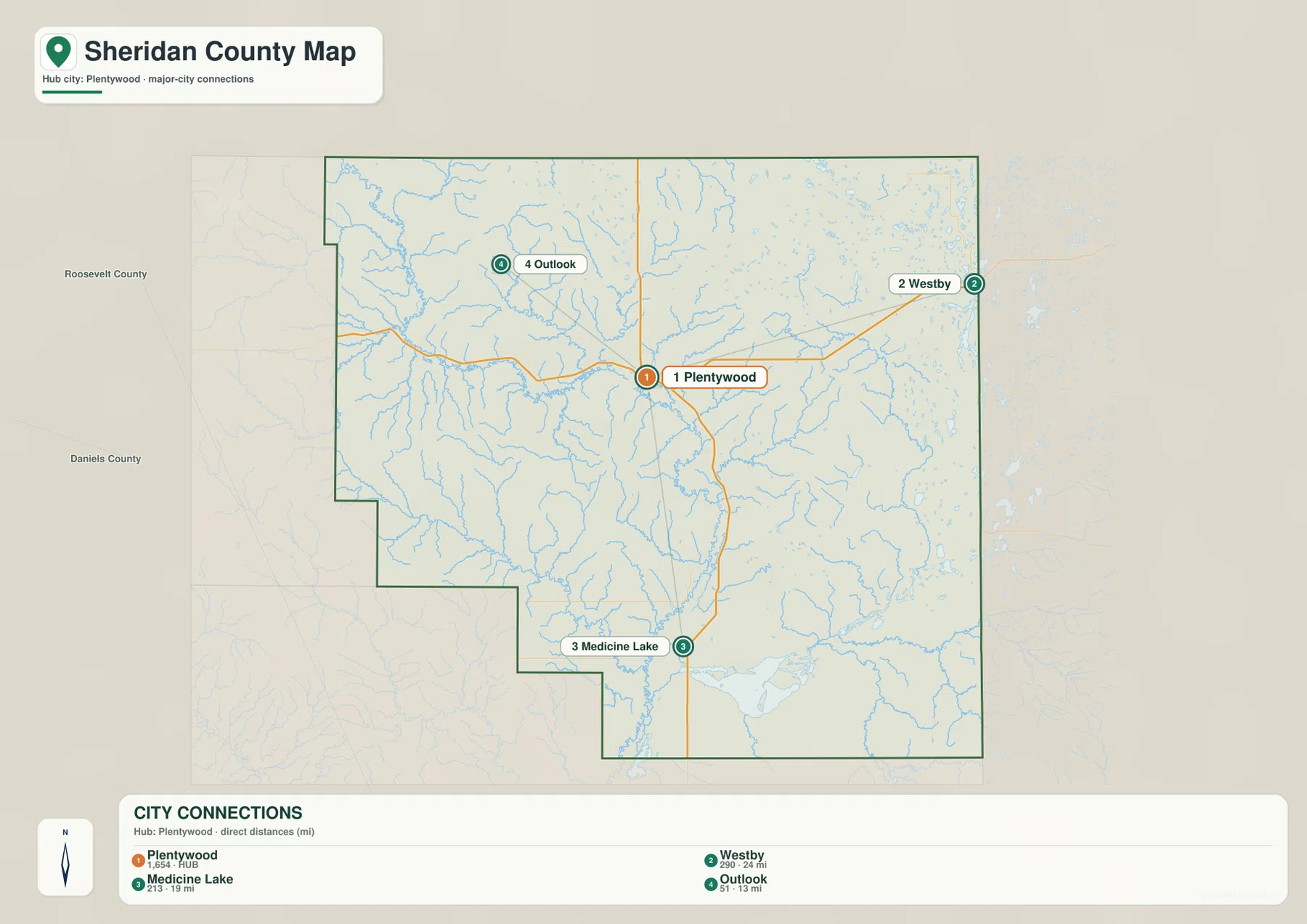
The city-connections map uses Plentywood as the hub. Its printed index lists Plentywood at 1,654, Westby at 290, Medicine Lake at 213, and Outlook at 51. These are values embedded in the supplied map and should not be treated as guaranteed current population estimates. Current demographic totals should be checked through recent U.S. Census Bureau data.
Outlook is labeled 13 miles from Plentywood, Medicine Lake 19 miles, and Westby 24 miles. All three are straight-line distances rather than driving mileage. Actual trips follow Route 5, Route 16, and local roads and can therefore be longer.
The three connections also show the county’s basic settlement pattern: Outlook to the northwest, Westby to the east, and Medicine Lake to the south. The city map is useful for relative location and direct-distance comparison, but it is not a routing map.
Big Muddy Creek and Plentywood Creek define the western and central drainage
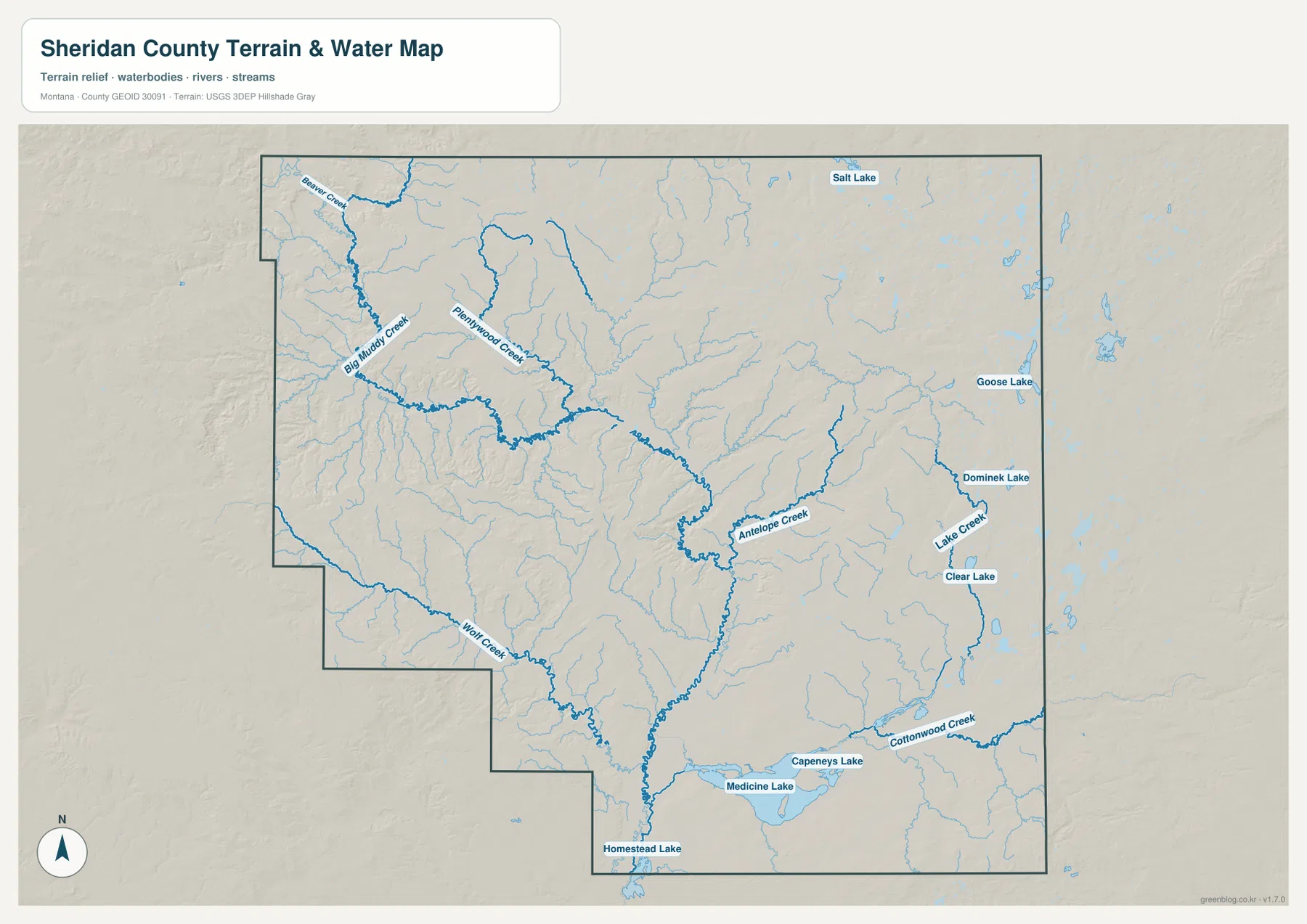
Big Muddy Creek is one of the strongest water references on the terrain-and-water map. It crosses the western and central county through a broad low drainage, while Beaver Creek approaches from the northwest. Plentywood Creek runs southeast from the Plentywood area and joins the same larger creek system.
South of Big Muddy Creek, numerous short tributaries cut through the prairie. Wolf Creek forms a longer drainage in the southwest. In a county with few large towns, these creek valleys provide useful local references for understanding the open western interior.
The terrain-and-water map is intended for geographic reference. It does not establish flood zones, water depth, parcel boundaries, water rights, navigation conditions, or safe stream crossings. Current water and access conditions should be checked through appropriate official sources.
Antelope Creek and Medicine Lake organize the eastern and southern prairie
Antelope Creek crosses the central-eastern county, while Lake Creek provides another long drainage farther east. Cottonwood Creek appears in the southeast near the Medicine Lake area. These streams divide otherwise broad prairie into a series of shallow valleys.
Salt Lake and Goose Lake provide landmarks in the northeast, while Clear Lake appears farther south. Medicine Lake is the largest and most prominent named lake on the map, with Homestead Lake nearby to the southwest. Sheridan County’s official attractions page also highlights Medicine Lake National Wildlife Refuge as an important wildlife area.
The map does not define the legal boundary of the refuge or any wetland-management zone. Visitors should use current agency information for refuge boundaries, access rules, seasonal closures, and recreation guidance.
Elevation ranges from about 587 to 843 meters
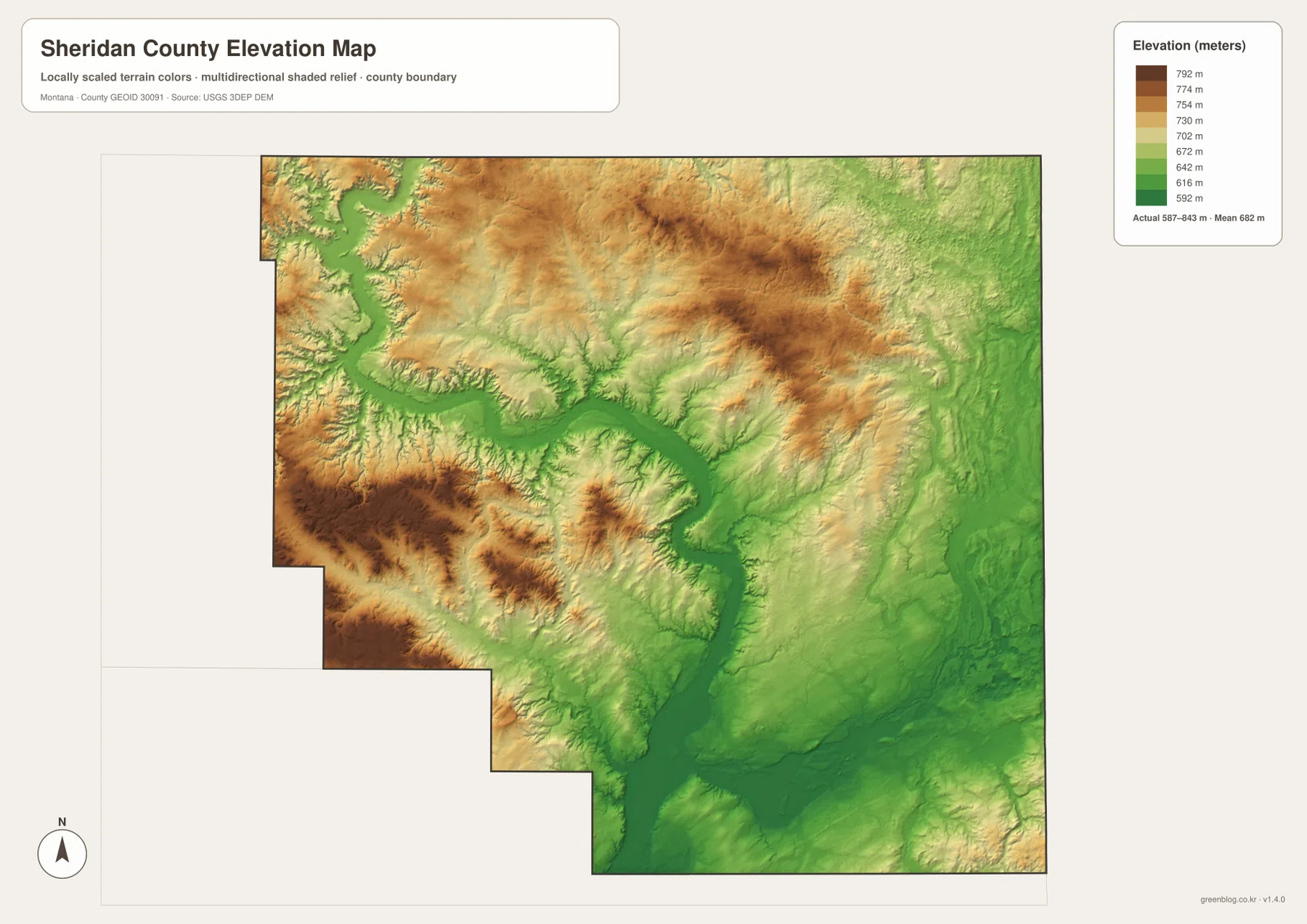
The elevation map reports an actual Sheridan County range of about 587 to 843 meters, with a mean elevation near 682 meters. The Big Muddy Creek corridor and the southern Medicine Lake area appear in darker and medium greens, marking the lower parts of the county.
Higher ground becomes more common along the west, southwest, and north-central uplands. These brown and yellow areas are broad rolling ridges rather than steep mountain terrain, and creek valleys cut green corridors through them. The eastern side is generally lower and smoother than the strongest western uplands.
Medicine Lake occupies one of the flatter southern lowlands, where several small drainages converge. The elevation map is intended for county-wide comparison only and should not be used as survey-grade or engineering-grade data for a specific property.
Plentywood and Big Muddy Creek provide a simple framework
A practical way to read Sheridan County is to begin with Plentywood and the crossing of Routes 5 and 16. Route 5 leads toward Redstone and Westby, while Route 16 provides the north-south reference toward Reserve and Medicine Lake. Outlook and Antelope add useful northwestern and east-central landmarks.
Water features provide the next layer. Big Muddy Creek and Plentywood Creek organize the west and center, Antelope and Lake creeks help with the east, and Cottonwood Creek provides a southeastern reference. Medicine Lake, Homestead Lake, Salt Lake, and Goose Lake make the flatter prairie easier to divide into recognizable areas.
The WebP images embedded in the article are convenient for quick browsing. The high-resolution JPG files in the ZIP are better for printing or enlarging small road, creek, and lake labels. Because these are static reference maps, current road access, water levels, and refuge rules should be checked through current official information.
Frequently Asked Questions
Are the Plentywood-to-Outlook, Medicine Lake, and Westby distances driving distances?
No. The city map shows 13 miles to Outlook, 19 miles to Medicine Lake, and 24 miles to Westby as straight-line distances from Plentywood. Actual driving distances follow Route 5, Route 16, and local roads and can be longer.
Where is the lowest terrain in Sheridan County?
The elevation map shows lower terrain along the Big Muddy Creek drainage and around Medicine Lake in the south. The western and north-central rolling uplands are higher.
Can the 587–843 meter elevation range be used for a property or engineering project?
No. The range is a county-wide reference for comparing lower creek valleys with higher prairie uplands. Precise site elevations should come from an authoritative source such as the USGS 3D Elevation Program and, when necessary, a professional survey.
Map File Information
Download the Sheridan County county, city, terrain-and-water, and elevation maps as high-resolution A3 JPG files.
- Included Files: county map, city map, terrain and water map, elevation map
- File Type: ZIP containing 4 JPG files
Related Maps
Sources and References
County government information is available from the official Sheridan County website. The Montana Association of Counties county-seat list identifies Plentywood as the Sheridan County seat. The county’s Area Attractions page highlights Medicine Lake National Wildlife Refuge and Medicine Lake.
Boundary and road-reference data can be checked through U.S. Census Bureau TIGER/Line Shapefiles. Hydrographic data are available from USGS National Hydrography, and elevation data through the USGS 3D Elevation Program.
Green Map creates custom-edited map images using open geographic data sources such as geoBoundaries, Natural Earth, OpenStreetMap, and government open data. These maps are edited visual materials, not raw data files, and are provided for education, documents, presentations, and graphic reference.