Leelanau County occupies one of Michigan’s most distinctive county shapes: a long peninsula between Lake Michigan and Grand Traverse Bay, accompanied by several offshore islands. Suttons Bay and Northport sit along the eastern side, Leland and Glen Arbor face Lake Michigan to the west, and Empire provides a useful southwestern reference near the Sleeping Bear Dunes area. This page separates roads and settlements, city relationships, water features, and elevation into four maps. High-resolution JPG copies of all four supplied sheets are available in the download box below.
Water defines the county almost as strongly as its roads. Lake Leelanau occupies a long north-south corridor through the interior, Glen Lake fills a broad basin in the southwest, and the mainland shoreline bends around bays, points, and narrow peninsulas. North and South Manitou Islands lie off the Lake Michigan side, while the Fox Islands appear farther north. A Leelanau County planning document describes M-22 as following both the eastern and western sides of the peninsula and identifies M-72, M-204, and M-109 as important connections between inland and shoreline communities.
Table of Contents
M-22 follows the peninsula while M-204, M-109, and M-72 connect across it
The general county map is easiest to orient from M-22. Entering the county from the southwest, the highway follows the Lake Michigan side toward Leland, turns around the northern peninsula near Northport, and continues down the Grand Traverse Bay side toward Suttons Bay. That curved route mirrors the shoreline and makes the north-south shape of the county immediately clear. Omena appears along the eastern shore between Northport and Suttons Bay, while Leland occupies the narrow western side between Lake Michigan and the long interior lake.
M-204 provides an important east-west crossing between the Leland side and Suttons Bay side. Because Lake Leelanau stretches through the middle of the peninsula, the highway crosses at a narrow section rather than cutting straight across open water. Farther south, M-109 links the Empire and Glen Arbor area through the Sleeping Bear Dunes corridor, while M-72 reaches Empire along the southern edge from the Traverse City direction. Maple City and Cedar sit inland from the shoreline roads, offering useful reference points for the southern interior.
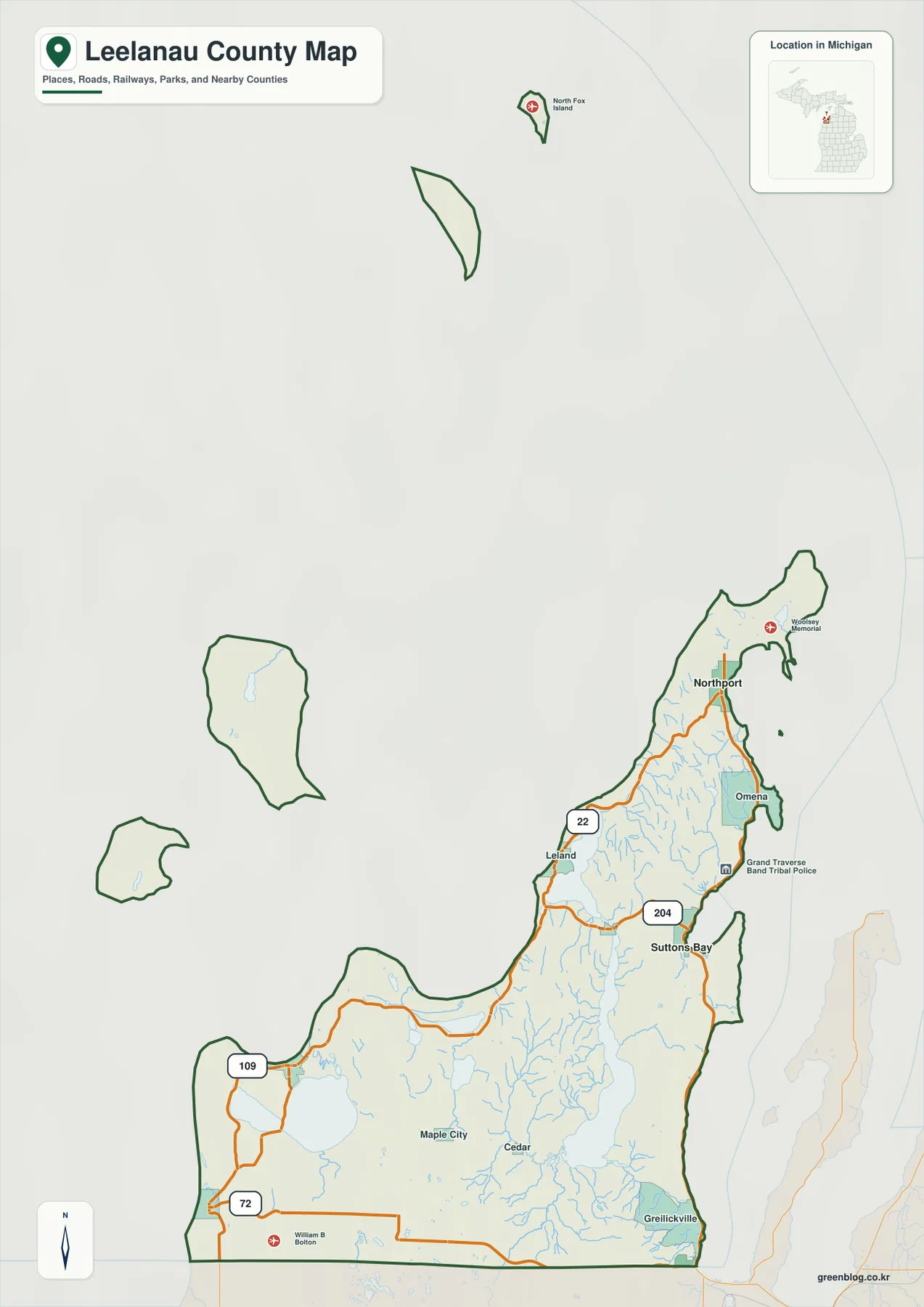
The settlement pattern is notably dispersed. Greilickville lies near the southeastern edge closest to Traverse City, Suttons Bay forms a central eastern reference, and Northport marks the far northern mainland. On the west side, Leland and Glen Arbor occupy separate Lake Michigan settings, with Empire farther south. The islands add another geographic layer because they belong to the county outline without being connected to the mainland road system. For current driving routes, closures, or travel times, this county map should be treated as a regional reference rather than a turn-by-turn navigation product.
Suttons Bay serves as the hub for a simple Northport and Empire comparison
The city-connection sheet simplifies the county to three labeled places. Suttons Bay is the hub, Northport is the second point, and Empire is the third. The map gives a direct distance of about 10 miles from Suttons Bay to Northport and about 23 miles from Suttons Bay to Empire. Those values are straight-line distances, not road mileage. The difference matters in Leelanau County because lakes, shorelines, and the shape of the peninsula often force roads to take a longer course than a direct line would suggest.
The three places also represent very different parts of the county. Suttons Bay sits midway down the Grand Traverse Bay side, Northport lies near the northern tip, and Empire is on the southwestern Lake Michigan side. The map therefore provides a quick way to see how far the county stretches between its eastern shore, northern end, and southern west coast. It is especially useful before returning to the general map, where M-22 and the cross-peninsula roads explain why the shortest geographic separation is not always the shortest practical drive.
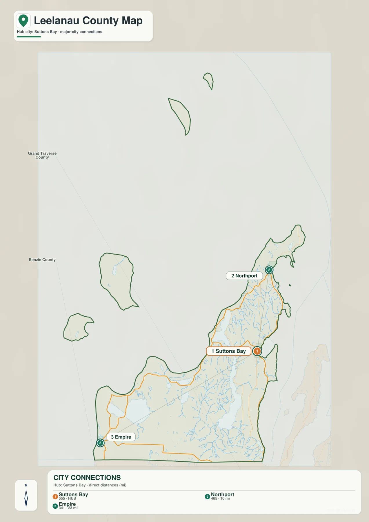
This sheet deliberately omits many other communities, so it should not be read as a complete city list or population ranking for the county. Leland, Glen Arbor, Cedar, Maple City, and Omena are better located on the general map. The connection sheet answers a narrower question: where are the three reference places relative to one another, and how far apart are they in a straight line? Once that relationship is clear, the road map supplies the practical route context.
Glen Lake, Lake Leelanau, and branching creeks create a dense inland water network
The terrain and water map makes the inland hydrography much more visible than the general road sheet. Glen Lake dominates the southwest, and Crystal River runs from the Glen Lake area toward Lake Michigan. Nearby labels include School Lake, Little Traverse Lake, and Lime Lake, each surrounded by smaller streams or wet lowlands. The National Park Service also identifies Crystal River and several small lakes as managed waters within the Leelanau County portion of Sleeping Bear Dunes National Lakeshore, reinforcing how strongly water shapes the southwestern landscape.
Farther east and north, Lake Leelanau forms the largest interior water corridor. The map labels Victoria Creek, Solon Creek, Cedar Run Creek, Mebert Creek, and Lee Creek among the many tributaries feeding or crossing the peninsula. Bright Lake, Pollack Lake, Armstrong Lake, and Steimel Lake add smaller inland basins to the southern and eastern interior. These features are easier to understand after the towns have already been located on the road map: the water sheet then shows why some roads curve around lakes or follow lower ground rather than taking a perfectly straight route.
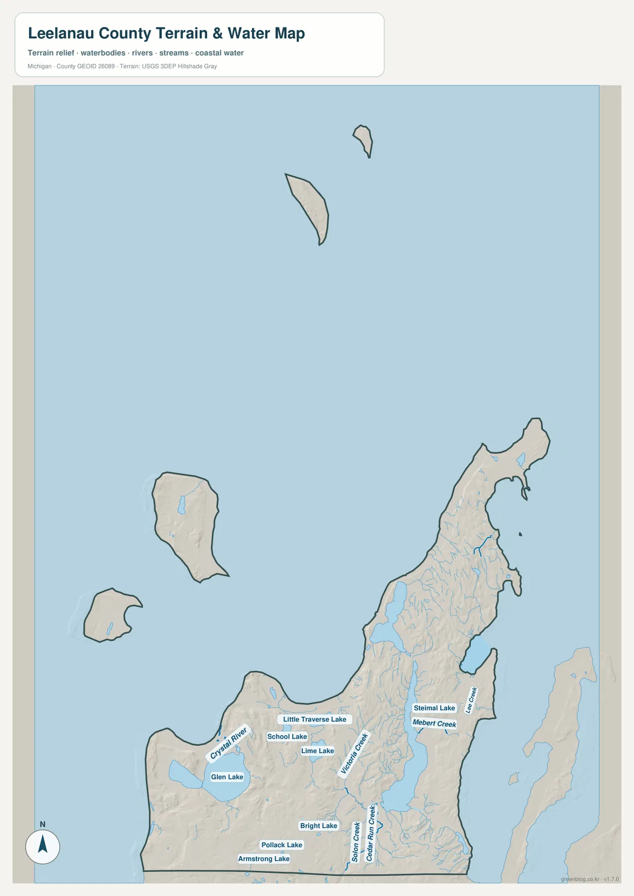
The offshore islands are part of the county geography as well, but they should be interpreted separately from the mainland road network. North and South Manitou Islands sit west of the peninsula, and the Fox Islands lie farther north in Lake Michigan. The water map is useful for general shoreline and hydrographic reference, not for navigation or regulatory decisions. It does not provide safe boating channels, water depths, flood elevations, wetland jurisdiction, or parcel boundaries, so those questions require the appropriate current official source.
Low shorelines surround ridges and hills that rise sharply through the interior
The elevation surface shows an actual range of roughly 170 to 355 meters, with a mean near 227 meters. Green tones dominate the lowest shorelines and several lake corridors, while yellows and browns appear across the higher interior. The contrast is especially strong in the south and southwest, where a series of hills rises behind the Lake Michigan shore. Lake Leelanau is bordered by lower terrain, but higher ridges stand only a short distance away on both sides, creating a much more varied landscape than the peninsula’s outline alone suggests.
The west side near Sleeping Bear Dunes is another place where shoreline and elevation interact closely. The National Park Service describes high dunes and bluffs above Lake Michigan, along with rolling hills around the Glen Lakes. On the county elevation map, the Glen Lake and western interior area shows abrupt shifts from low green basins to brighter upland colors. Moving north toward Leland and Northport, the peninsula narrows but does not become uniformly flat; long ridges continue between the lower shoreline margins.
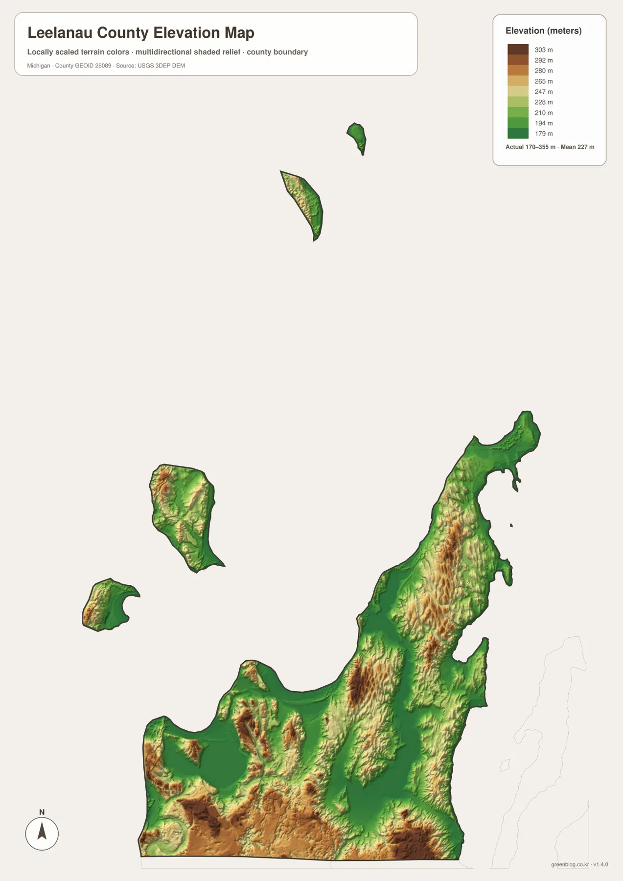
The islands also contain meaningful relief. North and South Manitou show low coastal margins together with higher interior terrain, and the Fox Islands display their own small-scale elevation changes. Even so, this sheet is a generalized county-scale surface. It is suitable for comparing broad high and low areas, but not for survey-grade elevations, engineering design, property grading, or precise slope calculations. Those tasks require original elevation data and, when necessary, site-specific field surveying.
A road-to-water-to-relief sequence makes the county easier to understand
For a first pass, start at Suttons Bay and use M-22 to establish the shape of the peninsula. Follow it north toward Northport, then use Leland on the west side and M-204 across the Lake Leelanau narrows to connect the two shores. Shift south to Glen Arbor and Empire, where M-109 and M-72 provide additional orientation. The city-connection sheet then reduces that geography to Suttons Bay, Northport, and Empire, making the large north-to-southwest spread of the county easy to remember.
Next, move away from roads and use Glen Lake and Lake Leelanau as water anchors. Crystal River and the smaller creeks become easier to place once those two lakes are fixed in mind. Finally, compare the same locations on the elevation map. Low lake and shoreline corridors sit remarkably close to steep or rolling uplands, especially around the southwestern dunes and the central peninsula. Looking at the maps in this order prevents the dense stream network or shaded relief from becoming overwhelming.
For printing or close inspection, the downloadable archive contains the original 2572 × 3638 pixel JPG files, which are larger than the WebP images embedded in the article. They are useful for classroom handouts, regional reference sheets, presentations, trip orientation, or any project that needs a clear county-scale view. The maps are not substitutes for legal boundary records, parcel surveys, flood-regulation products, marine charts, or engineering surveys. For specialized decisions, use the current authoritative dataset intended for that purpose.
Frequently Asked Questions
Are the Northport and Empire distances on the city map road distances?
No. The city-connection sheet gives direct, straight-line distances from the Suttons Bay hub: about 10 miles to Northport and about 23 miles to Empire. Actual driving distances are longer because the road network follows shorelines, lakes, and the shape of the peninsula. Use a current road map or navigation service when planning a trip.
Are Glen Lake and Lake Leelanau the same body of water?
No. Glen Lake is in the southwestern part of the county near the Lake Michigan and Sleeping Bear Dunes side, with Crystal River prominent nearby. Lake Leelanau is a separate, much longer inland lake extending through the central peninsula. M-204 crosses the narrow section between its northern and southern portions while linking the Leland and Suttons Bay sides.
Can the 170–355 meter elevation range be used for a property survey?
No. The elevation map is a generalized surface designed to compare county-scale high and low areas. It is useful for seeing low shorelines, lake basins, and higher interior ridges, but exact property elevations, drainage design, grading, construction, and slope measurements require authoritative elevation data and site-specific surveying.
Sources and Reference Information
- Leelanau County, Michigan official website: county government and local information.
- Leelanau County Community Parks and Recreation Plan: county transportation network and shoreline context.
- Sleeping Bear Dunes National Lakeshore: official information on the dunes, Glen Lakes, Lake Michigan shoreline, and island landscapes.
- U.S. Census Bureau TIGER/Line Shapefiles: county boundary and road reference.
- USGS National Hydrography: river, lake, and stream reference.
- USGS 3D Elevation Program: elevation-data reference.
Map File Information
The ZIP contains the original high-resolution JPG files for the county map, city connection map, terrain and water map, and elevation map. They are larger than the WebP images used in the article and are better suited to close viewing and printing.
- Included Files: Use only the versions confirmed in the article and supplied images
- File Type: Use the confirmed download contents
- Intended Use: Printing, education, presentations, and map-based projects
Related Maps
Green Map creates custom-edited map images using open geographic data sources such as geoBoundaries, Natural Earth, OpenStreetMap, and government open data. These maps are edited visual materials, not raw data files, and are provided for education, documents, presentations, and graphic reference.