Lenawee County occupies the southeastern part of Michigan’s Lower Peninsula, touching Ohio along its southern edge and spreading west from Monroe County toward Hillsdale County. Adrian sits near the middle of the county and provides an easy reference point for locating Tecumseh and Clinton to the north, Blissfield to the southeast, Hudson to the west, and Morenci near the southwestern state line. The maps on this page separate roads and communities, the city pattern, rivers and lakes, and elevation so the county can be studied without crowding every feature onto one sheet. The original high-resolution JPG map files are also available together in the download box below.
The county has two landscapes that become obvious when the sheets are compared. The eastern and southeastern side is broad and relatively low, with long drainage lines and a more open surface, while the northwest rises into hillier ground dotted with lakes. Lenawee County’s official website lists 59 lakes and about 334,000 acres of agricultural land, a combination that fits the visual contrast between the lake country in the northwest and the extensive rural landscape elsewhere. The road network follows that geography rather than forming a single urban grid.
Table of Contents
Adrian anchors a road network that reaches every side of the county
Adrian is the clearest starting point on the general county map because several major routes meet or pass close to the city. US-223 heads southeast from the Adrian area toward Blissfield and the Monroe County side. M-52 runs north through Tecumseh and toward Clinton, while continuing south from Adrian toward the Ohio line. M-34 extends west through the central part of the county toward Hudson and Clayton. Together, these routes create a simple framework for remembering where the principal communities sit.
The northern edge has a different set of connections. US-12 crosses the upper part of Lenawee County and passes near the lake district, while US-127 follows the western side near the Hillsdale County boundary. M-50 runs through Tecumseh and Britton across the northeast, giving the county an important east-west route away from Adrian. M-124 is useful around the northwest lake area, where the roads bend more often around water and rolling terrain. This makes the northwestern corner look noticeably less regular than the flatter southeast.
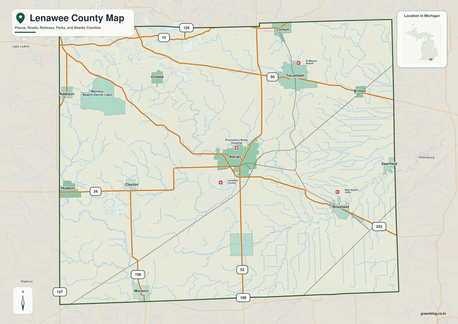
The county boundary helps explain the direction of those routes. Washtenaw and Jackson counties lie to the north, Hillsdale County is on the west, and Monroe County borders the east. The entire southern boundary meets Ohio, placing Morenci and other southern communities close to an interstate state line even though they remain part of Michigan. Adrian’s central position is therefore useful for orientation, but no single road serves every corner equally well. Trips toward the lake district, the Ohio border, or the northeast each rely on different corridors.
Six city markers show how widely the main population centers are separated
The city-index sheet highlights Adrian, Tecumseh, Blissfield, Clinton, Hudson, and Morenci. Adrian is the central marker, while Tecumseh and Clinton form a north-to-northeast pair. Blissfield sits well to the southeast, Hudson is close to the western edge, and Morenci lies near the southwest corner. The result is a dispersed settlement pattern rather than a cluster in one part of the county. That spacing matters when using a county-scale map because a destination can be many miles from Adrian even if it is still within the same county.
Each marker also connects naturally with a different road. Tecumseh is easy to locate from M-52 and M-50, Blissfield from US-223, Hudson from M-34, and Clinton from the northern road network near US-12. Morenci is separated from the other five by its position near the Ohio line in the southwest. These relationships are more useful for practical orientation than the rank numbers alone, since the map is intended to show where the cities are rather than to serve as a current population table.
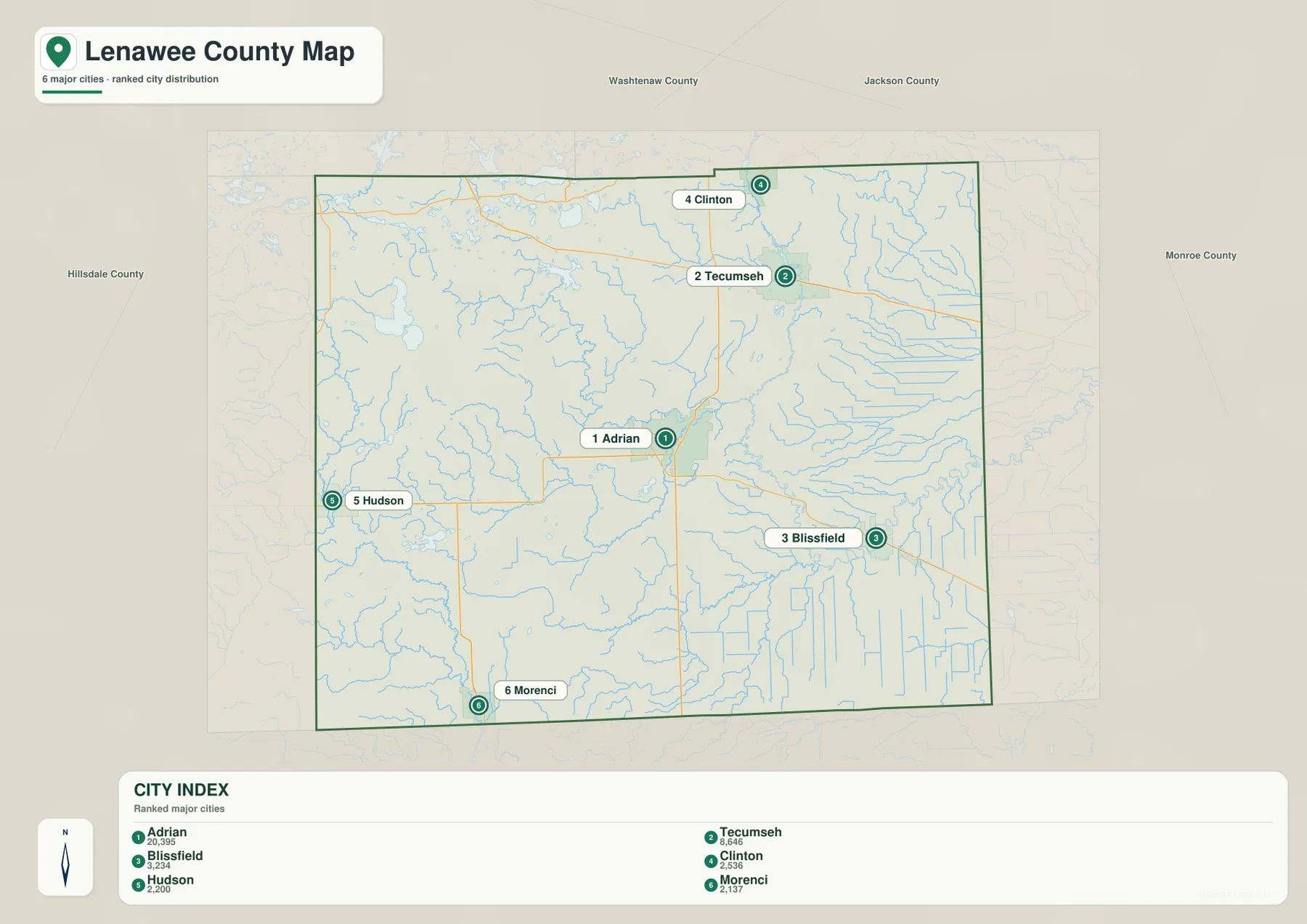
The six labels are not a complete list of communities. Addison, Onsted, Britton, Deerfield, Clayton, and the Manitou Beach-Devils Lake area appear on the more detailed county map and add important local reference points. The city sheet is best used as a quick mental framework; the general map should be used when a smaller community, specific highway, or nearby county boundary matters. This distinction is especially helpful in the northwest, where lakes and smaller settlements create a different pattern from Adrian and the southeast.
The River Raisin system crosses the center while lake country gathers in the northwest
The terrain-and-water map gives the county a very different appearance. River Raisin is the dominant named river through the central and northeastern part of the sheet. South Branch River Raisin approaches from the south and southwest, while Wolf Creek joins the system from the west-central area. Black Creek and South Branch Little River Raisin stand out farther east and southeast. The pattern shows that the county is drained by several branches rather than one straight river crossing the map from border to border.
Other named streams help separate the outer parts of the county. Bean Creek and Bear Creek appear in the southwest near the Hudson and Morenci side, and Middle Branch Macon River is labeled near the northeastern boundary. Numerous smaller channels are visible across the east and southeast. When the water sheet is compared with the road map, the relationship between Adrian, Tecumseh, Blissfield, and the River Raisin network becomes much easier to understand than it is from road names alone.
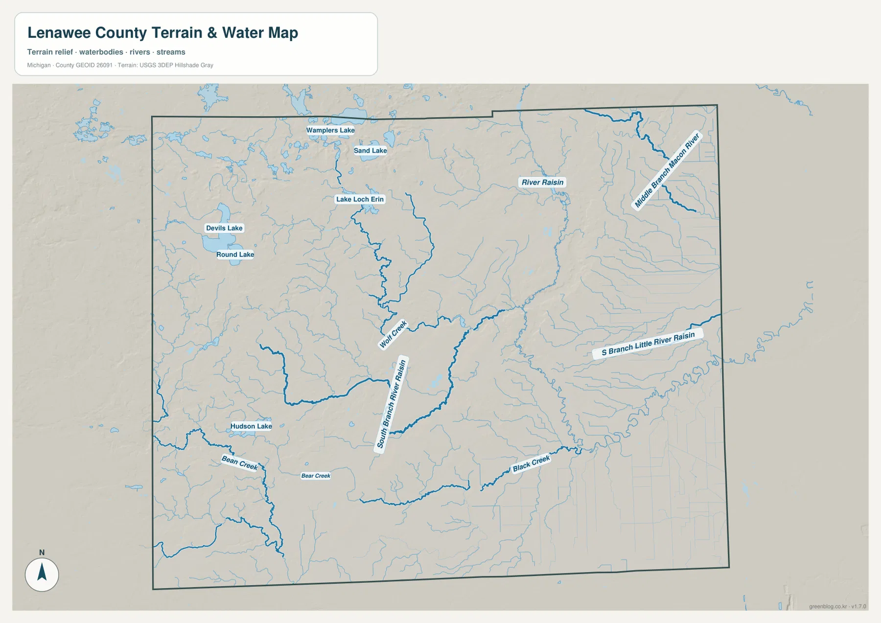
The strongest lake concentration is in the northwest. Wamplers Lake, Sand Lake, Lake Loch Erin, Devils Lake, and Round Lake are all labeled within a relatively compact area, while Hudson Lake appears farther southwest. The county’s official history notes that more than 50 lakes occur in Lenawee County and describes most of them as products of the glacial landscape left after the ice retreated. That background helps explain why the northwest combines enclosed lakes and rolling ground while the southeastern side looks more open. The water map is a geographic reference only; it does not show navigation channels, water depths, regulatory flood elevations, or legal wetland boundaries.
Relief rises toward the west and northwest and falls across the southeast
The elevation sheet has an actual mapped range of about 202 to 370 meters, with a mean near 251 meters. The highest browns and darker upland tones occupy much of the west and northwest, especially toward the Hillsdale and Jackson county sides. That elevated area includes the region around the northwest lakes, where short ridges and depressions create a textured surface rather than a broad plain. The difference is visible even without town labels because the color transition is so strong across the county.
Moving east from the Adrian area, greens become more widespread and the surface appears smoother. Blissfield and Deerfield are on the lower side of the overall county pattern, and the southeastern corner remains predominantly low in comparison with the northwest. The River Raisin and its tributaries occupy lower corridors through this landscape, producing narrow valleys that can be traced on the shaded surface. Adrian sits near the broad transition between the higher western ground and the lower eastern half.
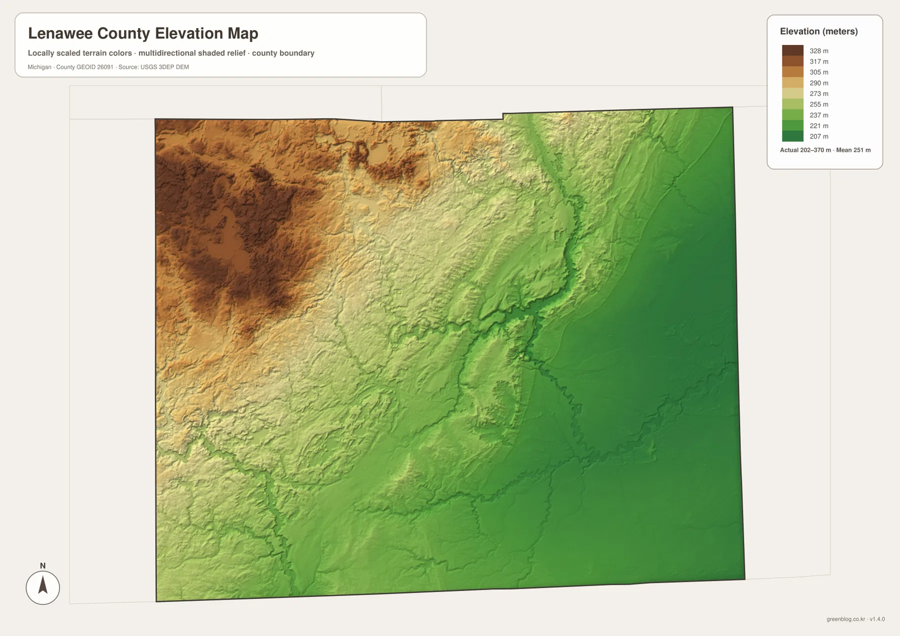
Comparing elevation with hydrography clarifies why the northwest lake district feels different from the southeast. Many lakes occupy lower pockets among rolling uplands, while the River Raisin system follows broader low corridors toward the east. The map is generalized at county scale, however, and should not be treated as a survey surface. Property elevations, construction grades, drainage engineering, and precise slope measurements require the original USGS data or a site survey with the accuracy needed for that decision.
A simple sequence makes the four map views easier to combine
For a first look, begin with Adrian and the major road network. Find US-223 and M-52, then place Tecumseh and Clinton to the north, Blissfield to the southeast, Hudson to the west, and Morenci near the southern border. Add US-12 and US-127 to understand the northern and western edges. Once that framework is familiar, the city-index sheet becomes a quick way to remember the spacing of the six principal markers without the distraction of smaller roads and streams.
Next switch to water. River Raisin, South Branch River Raisin, and Wolf Creek provide a central framework, while Wamplers Lake and Devils Lake anchor the northwest lake group. The elevation map can then be read against those same locations: the northwest becomes higher and rougher, while the southeast is lower and more even. This road-to-water-to-relief sequence makes it easier to understand why the county’s communities and transportation routes are spread the way they are.
The WebP images in the article are sized for convenient online viewing, while the download archive contains 2572 × 3638 pixel JPG originals for each map. The larger files are better for close inspection, classroom handouts, presentations, regional planning discussions, and printing. They remain general-purpose reference maps rather than legal or engineering documents. Parcel boundaries, official road closures, flood regulations, navigation, construction, and survey work should always use the current authoritative source created for that purpose.
Frequently Asked Questions
Why are so many Lenawee County lakes concentrated in the northwest?
The supplied water map places Wamplers Lake, Sand Lake, Lake Loch Erin, Devils Lake, and Round Lake close together in the northwest. Lenawee County’s official history describes most of the county’s many lakes as features associated with the landscape left by retreating glaciers. The elevation map also shows more rolling relief in this part of the county, which helps distinguish the lake district from the flatter southeast.
Which roads are the easiest references for finding Adrian, Tecumseh, and Blissfield?
M-52 is the clearest north-south reference between Adrian and Tecumseh, while US-223 is the prominent route from the Adrian area toward Blissfield in the southeast. M-50 is useful around Tecumseh, and M-34 leads west toward Hudson. These maps are suitable for general orientation, but current routing, construction, and traffic conditions should be checked with an up-to-date road or navigation source.
Can the 202–370 meter elevation range be used as a property elevation?
No. That range describes the generalized county-scale elevation surface shown on this map. It is useful for comparing the higher west and northwest with the lower east and southeast, but it is not accurate enough for a specific lot, building pad, drainage design, grading plan, or legal survey. Those tasks require suitable original elevation data and, when necessary, field surveying.
Sources and Reference Information
- Lenawee County, Michigan official website: county facts and local information.
- Lenawee County History: official county history and background on the lake landscape.
- U.S. Census Bureau TIGER/Line Shapefiles: county-boundary and road reference.
- USGS National Hydrography: river, lake, and stream reference.
- USGS 3D Elevation Program: elevation-data reference.
Map File Information
The ZIP contains the original high-resolution JPG files for the Lenawee County general map, city-index map, terrain and water map, and elevation map. They are larger than the WebP images embedded in the article and are better suited to printing and close inspection.
- Included Files: Use only the versions confirmed in the article and supplied images
- File Type: Use the confirmed download contents
- Intended Use: Printing, education, presentations, and map-based projects
Related Maps
Green Map creates custom-edited map images using open geographic data sources such as geoBoundaries, Natural Earth, OpenStreetMap, and government open data. These maps are edited visual materials, not raw data files, and are provided for education, documents, presentations, and graphic reference.