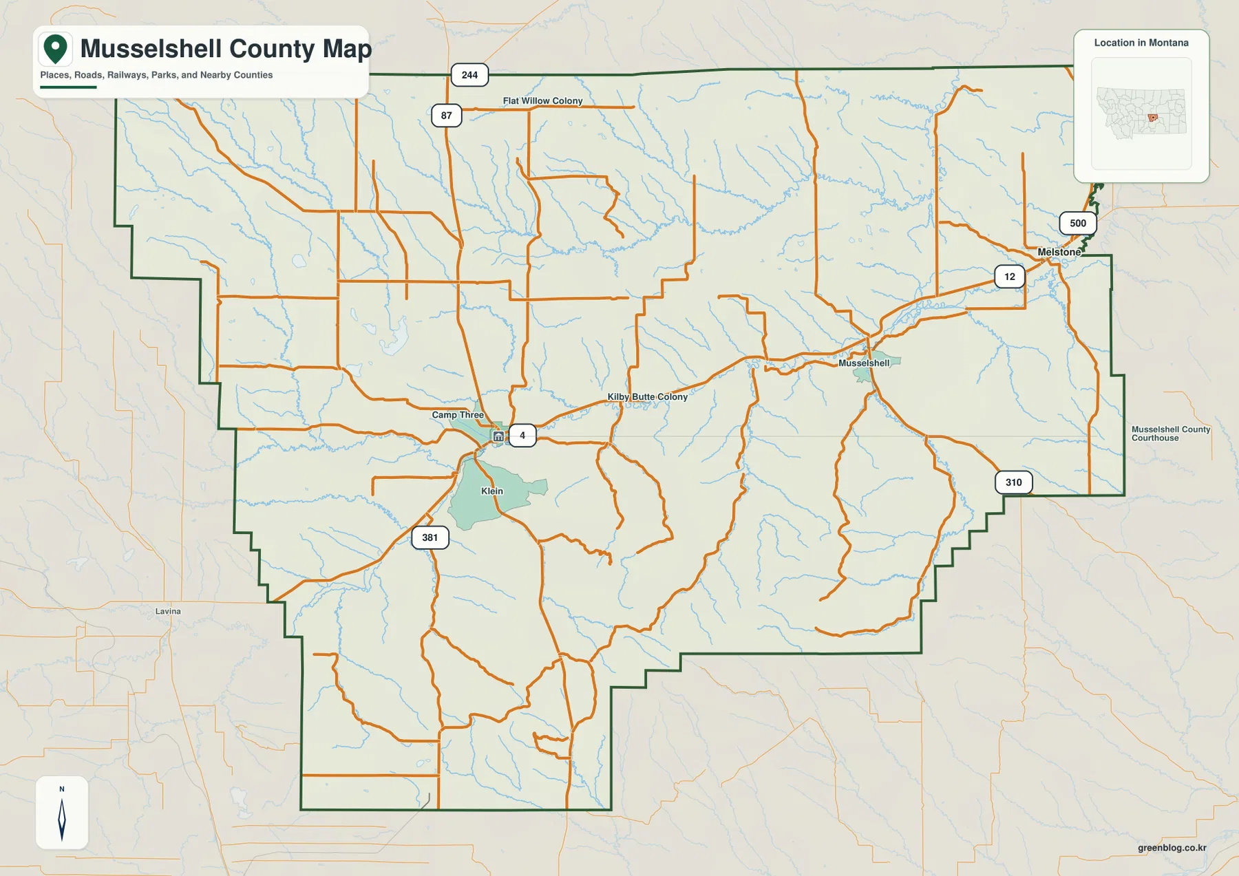
Musselshell County stretches across central Montana with Roundup as its main settlement and the Musselshell River forming the clearest east-west geographic corridor. Melstone marks the eastern side, while Musselshell, Klein, Camp Three, and Kilby Butte Colony provide additional local references along or near the river valley. The road map shows U.S. 12 around the Melstone side, routes 87 and 244 in the north, and routes 310, 381, and 500 in other rural sections. The terrain-and-water map adds Willow Creek, Pole Creek, Fattig Creek, Hawk Creek, and several small lakes, while the elevation view shows a lower river corridor bordered by higher southern and northwestern country. High-resolution JPG versions of the maps are available together in the download ZIP below.
Musselshell County’s official website places county government offices in Roundup, which matches the supplied map’s settlement pattern. Roundup is the clearest road hub, while Melstone provides the most useful eastern city reference. Beyond those places, creek valleys and relief become increasingly important for understanding the county, especially across the sparsely settled north and the more rugged southern half.
Table of Contents
Roundup is the main road and settlement hub
On the general county map, Roundup lies slightly west of center along the Musselshell River corridor. Camp Three and Klein appear nearby, and the settlement labeled Musselshell lies farther east along the same broad valley. Roads spread north and south from the Roundup area into a much more rural interior.
Routes 87 and 244 provide northern references, with Flat Willow Colony labeled nearby. Route 381 descends through the southwestern side near Klein, while several unnumbered local roads cross the central and southern hills. Lavina appears outside the western boundary as a regional reference rather than a place inside Musselshell County.
Toward the east, U.S. 12 serves the Melstone side and Route 500 connects at Melstone. Route 310 provides another reference in the southeast. The map is useful for geographic orientation, but current construction, winter restrictions, and local road conditions should be checked separately before travel.
Melstone marks the eastern end of the main valley
Melstone sits close to the eastern boundary and is one of the county’s two ranked cities. U.S. 12 passes the area, and Route 500 extends north from the Melstone side. West of town, both the road corridor and Musselshell River lead back toward the central county.
The settlement named Musselshell appears between Roundup and Melstone. Because the county, river, and settlement share the same name, it is useful to distinguish them carefully when reading labels. The settlement lies in the eastern half along the river corridor rather than at the county’s geographic center.
South and southeast of the main valley, settlement labels become sparse and relief becomes more pronounced. Route 310 provides a road reference, but creek valleys and terrain are often more helpful than town names for understanding this part of the county.
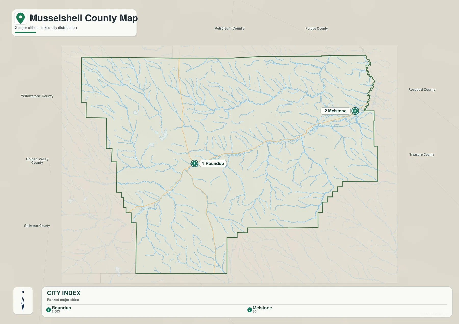
Roundup and Melstone are the two ranked cities
The city map ranks two places: Roundup and Melstone. Its CITY INDEX lists Roundup at 2,003 and Melstone at 80. These values are embedded in the supplied map and should not be treated as guaranteed current population estimates. Current demographic totals should be checked through recent U.S. Census Bureau data.
Roundup lies in the west-central interior, while Melstone sits close to the eastern boundary. Surrounding labels include Petroleum and Fergus counties to the north, Rosebud and Treasure counties to the east, Stillwater and Golden Valley counties toward the southwest and west, and Yellowstone County as another western regional reference.
No connector line or mileage label is printed between Roundup and Melstone. The map spacing should therefore be treated only as a location reference, not as straight-line distance or road mileage. Actual travel should be checked on the general road map and with current navigation information.
Musselshell River forms the county’s central water corridor
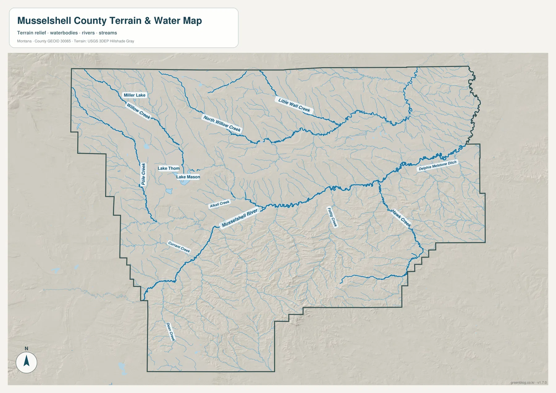
The terrain-and-water map is dominated by Musselshell River, which crosses the county from west to east through a long lower valley. The main settlement corridor follows the same general direction, making the river the strongest natural reference for Roundup, Musselshell, and Melstone.
Pole Creek and Currant Creek enter from the western and southwestern side, while Alkali Creek reaches the river farther east. Fattig Creek and Hawk Creek descend from the southern uplands in the eastern half. Near Melstone, the map also labels Delphia Melstone Ditch as a separate water feature.
The terrain-and-water map is intended for geographic reference. It does not establish flood zones, water depth, parcel boundaries, water rights, navigation conditions, or safe stream crossings. Current water and access conditions should be checked through the appropriate official sources.
Willow Creek and small lakes organize the northwestern country
Willow Creek and North Willow Creek run through the northwestern interior, while Little Wall Creek occupies a separate northern valley farther east. These drainages reveal much more detail than the road map in areas where settlement labels are scarce.
Miller Lake sits near the Willow Creek side. Lake Thom and Lake Mason appear farther south and relatively close together, providing useful landmarks in rolling country east of Pole Creek. The small water bodies are easy to miss at screen size, so the high-resolution files are useful when their labels matter.
The southern county contains many shorter tributaries and more broken relief. Dean Creek is labeled toward the southwest, and numerous unnamed channels cut through the uplands south of Musselshell River. This change becomes even clearer on the elevation map.
Elevation ranges from about 827 to 1,496 meters
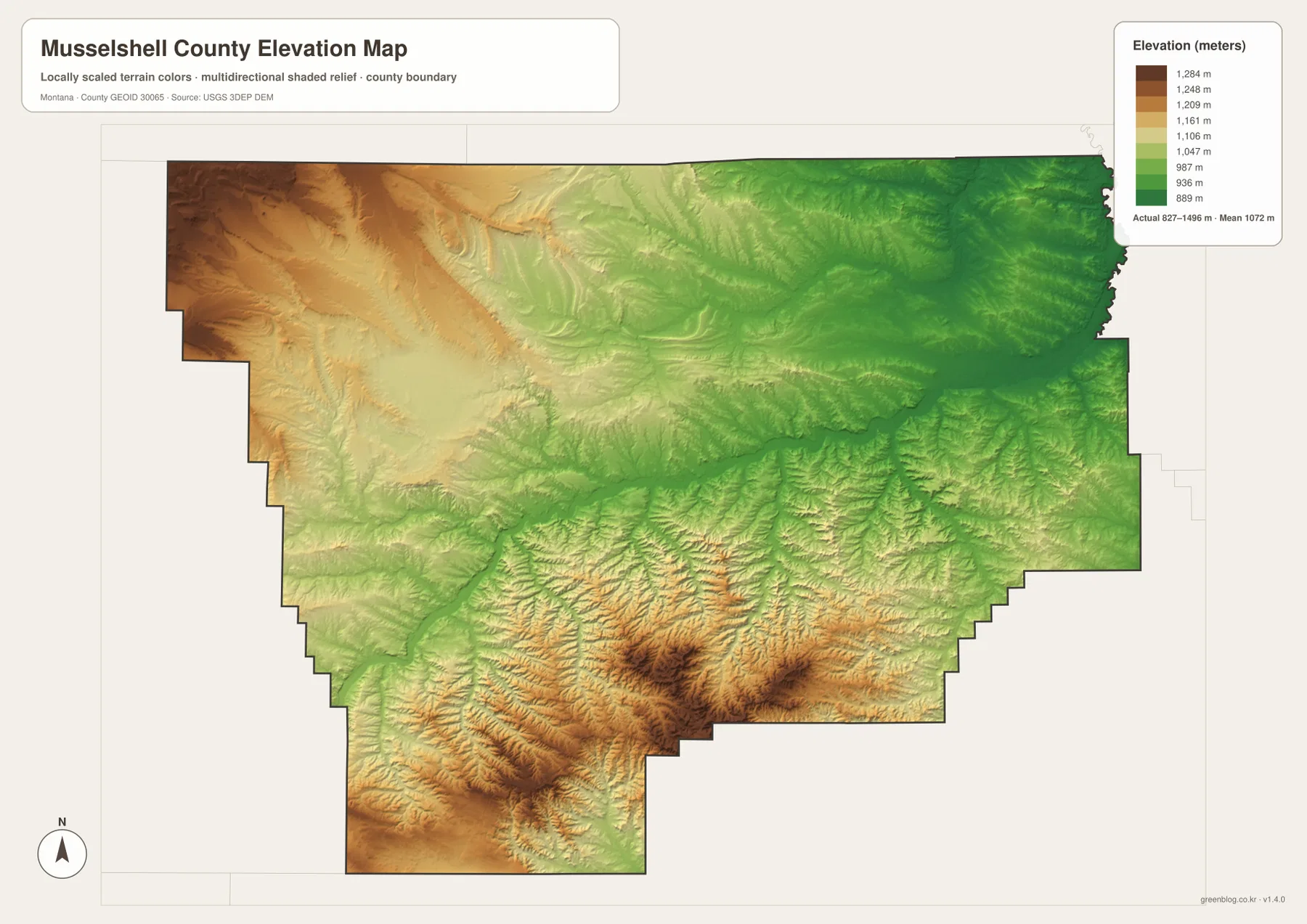
The elevation map reports an actual county range of about 827 to 1,496 meters, with a mean elevation near 1,072 meters. Much of the east and northeast appears in green, and Musselshell River follows a lower corridor across the center.
The highest terrain is concentrated in the south-central and southwestern uplands, with another broad high area along the northwestern edge. Numerous small valleys cut through the southern ridges, creating a much rougher surface than the main river corridor.
The Roundup-to-Melstone valley remains lower and gentler than the southern country. Northern terrain is generally rolling, though elevation increases noticeably toward the northwest. The elevation map is intended for county-wide comparison only and should not be used as survey-grade or engineering-grade data for a specific property.
Roundup and Musselshell River provide a simple framework
A practical way to read Musselshell County is to start with Roundup as the road reference and Musselshell River as the natural reference. Follow the river and U.S. 12 direction east toward Musselshell and Melstone, then add routes 87 and 244 for the northern side.
Water features provide more detail away from the main valley. Willow Creek, North Willow Creek, and Little Wall Creek help with the north, Pole and Currant creeks help with the west, and Alkali, Fattig, and Hawk creeks distinguish the central and eastern rural areas. Lake Thom, Lake Mason, and Miller Lake provide additional local landmarks.
The WebP images embedded in the article are convenient for quick browsing. The high-resolution JPG files in the ZIP are better for printing or enlarging small road, creek, and lake labels. Because these are static reference maps, current road access and water conditions should be checked through current official information.
Frequently Asked Questions
Does the city map show the distance between Roundup and Melstone?
No. The city map ranks and locates Roundup and Melstone but does not print a connector line, straight-line distance, or road mileage between them. Use the general county map and current navigation information for an actual trip.
Where is the highest terrain in Musselshell County?
The elevation map shows the highest uplands mainly in the south-central and southwestern county, with another high area in the northwest. The Musselshell River corridor and much of the east are lower.
Can the 827–1,496 meter elevation range be used for a property or engineering project?
No. The range is a county-wide reference for comparing the lower river corridor with surrounding uplands. Precise site elevations should come from an authoritative source such as the USGS 3D Elevation Program and, when necessary, a professional survey.
Map File Information
Download the Musselshell County county, city, terrain-and-water, and elevation maps as high-resolution A3 JPG files.
- Included Files: county map, city map, terrain and water map, elevation map
- File Type: ZIP containing 4 JPG files
Related Maps
Sources and References
County government information is available from the official Musselshell County website, whose public documents use Roundup for county offices and administration.
Boundary and road-reference data can be checked through U.S. Census Bureau TIGER/Line Shapefiles. Hydrographic data are available from USGS National Hydrography, and elevation data through the USGS 3D Elevation Program.
Green Map creates custom-edited map images using open geographic data sources such as geoBoundaries, Natural Earth, OpenStreetMap, and government open data. These maps are edited visual materials, not raw data files, and are provided for education, documents, presentations, and graphic reference.