Garden County occupies a striking transition zone in western Nebraska. Oshkosh and Lewellen sit in the low North Platte River corridor, while the northern half rises into the Nebraska Sandhills, where shallow lakes and wetlands fill low basins between grass-covered dunes. Roads and settlements are concentrated in the southern valley, but long rural routes extend north through ranch country and scattered wetland complexes. High-resolution map files are available for download in the section below.
This page explains Oshkosh and Lewellen, U.S. 26 and Nebraska Highways 27 and 92, North Platte River and named lakes such as Crescent, Island, Hackberry, and Whitehead, plus an elevation range of about 997 to 1,268 meters. The original high-resolution JPG versions of the supplied maps can also be downloaded together in a ZIP for printing, classroom use, or personal reference.
Table of Contents
Oshkosh anchors the county along the North Platte corridor
Oshkosh is the Garden County seat and the county’s largest community. Garden County’s official website says the county was created in 1909 from the northern portion of Deuel County, with Oshkosh selected as the county seat. On the map, Oshkosh lies close to the North Platte valley and major east-west transportation routes, making it the clearest starting point for orientation.
Lewellen lies east of Oshkosh along the same river and highway corridor, while Lisco appears farther west. Those southern settlements contrast sharply with the northern half, where population is sparse and the map is dominated by Sandhills lakes, wetlands, and ranch roads rather than towns.
The county name grew from local promotion. Garden County and the Nebraska Association of County Officials credit Oshkosh real-estate agents John and William Twiford with suggesting “Garden” because they believed the region could become the “garden spot of the west.” Voters approved separation from Deuel County in 1909.
U.S. 26 follows the populated North Platte Valley through Oshkosh and Lewellen
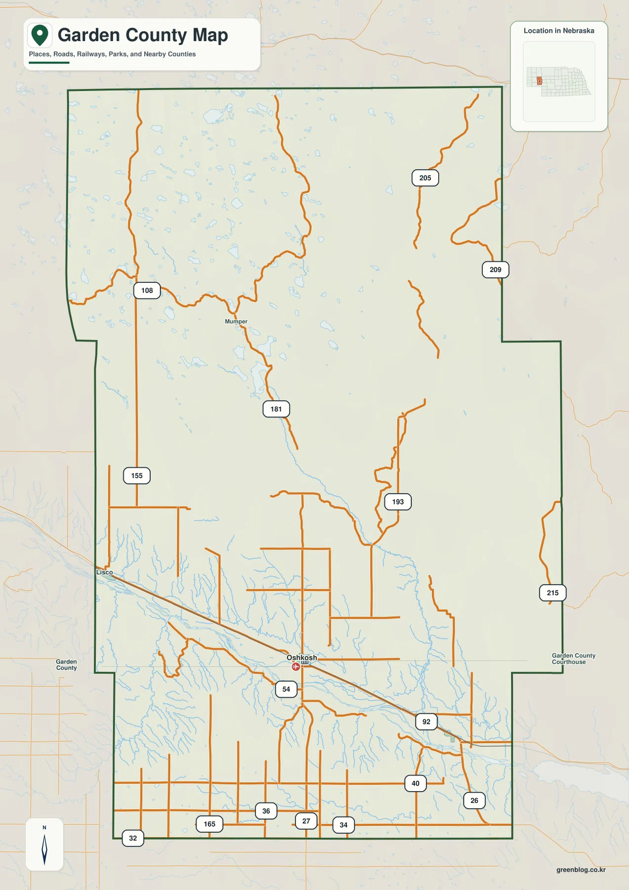
Garden County identifies U.S. Highway 26, Nebraska Highway 27, and Nebraska Highway 92 as its principal highways. U.S. 26 follows the North Platte valley through Oshkosh and Lewellen and provides the strongest east-west travel reference. A rail line follows the same broad corridor, reinforcing the close relationship between settlement and the river lowland.
Highway 27 extends away from Oshkosh, while 92 and several county roads serve the river corridor. Roads numbered 155 and 108 appear on the western side, and Road 181 reaches far north toward the Sandhills interior. Roads 193, 205, 209, and 215 provide additional references across the central and eastern rural areas.
The road pattern changes dramatically north of the river. The southern valley has more continuous road and rail connections, while the Sandhills contain wider road spacing and longer stretches between intersections because dunes, wetlands, and shallow lakes interrupt the landscape. Current road surfaces and seasonal conditions should be checked with local or Nebraska transportation sources before travel.
The city map compares only Oshkosh and Lewellen
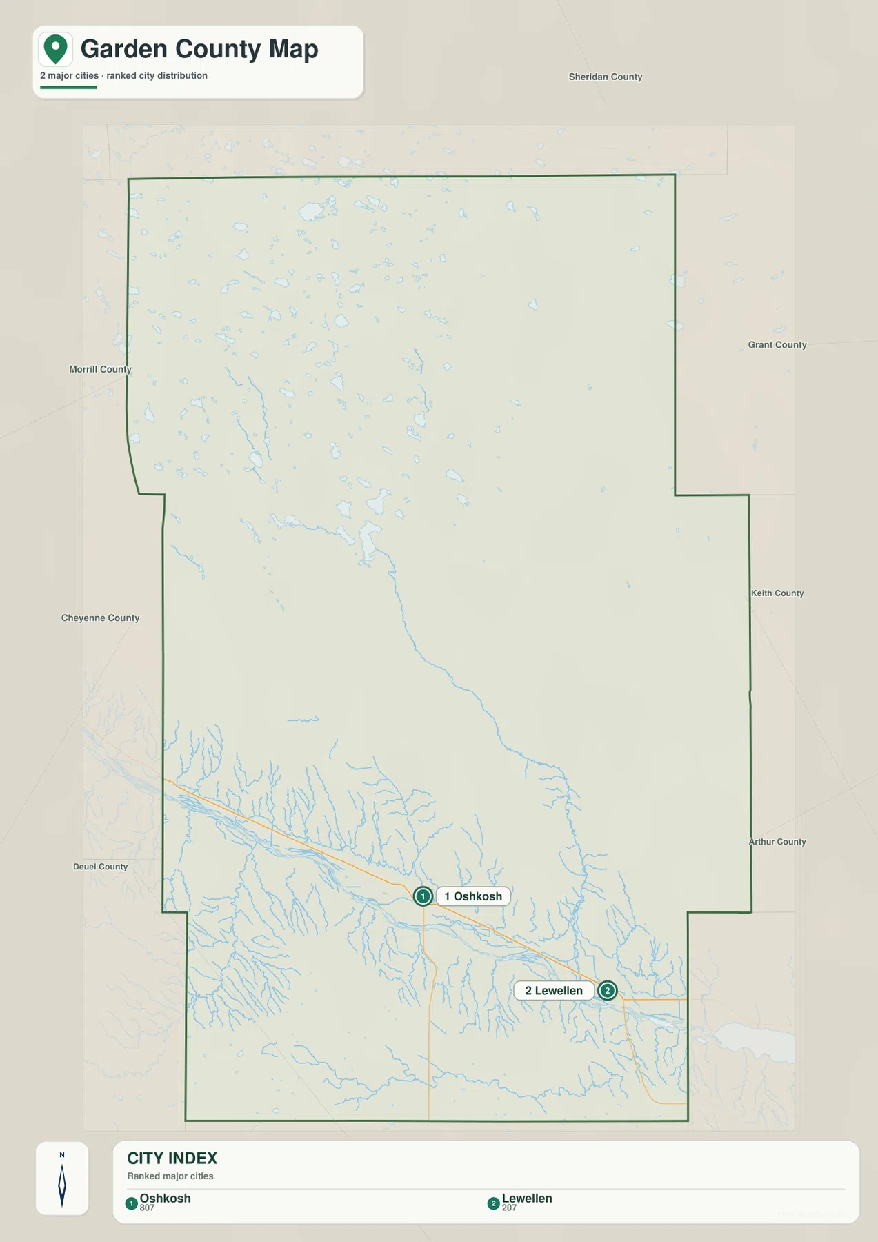
The city distribution map ranks Oshkosh first and Lewellen second. Oshkosh lies near the south-central portion of the county, while Lewellen is farther east. Both occupy the North Platte and U.S. 26 corridor, and no comparably ranked community appears across the much larger northern half.
No connector line or mileage value appears on the supplied city map. The useful comparison is therefore positional rather than numerical. Pairing it with the road map shows that the two major communities share the same east-west river corridor, while actual driving distance should be checked with a current routing service.
The values printed on the supplied graphic are 807 for Oshkosh and 207 for Lewellen. They belong to the ranked-city map and should not be treated as a continuously updated demographic table. Current population figures should be checked with the U.S. Census Bureau or official county sources when needed.
North Platte River lowlands give way to lake-filled Sandhills basins
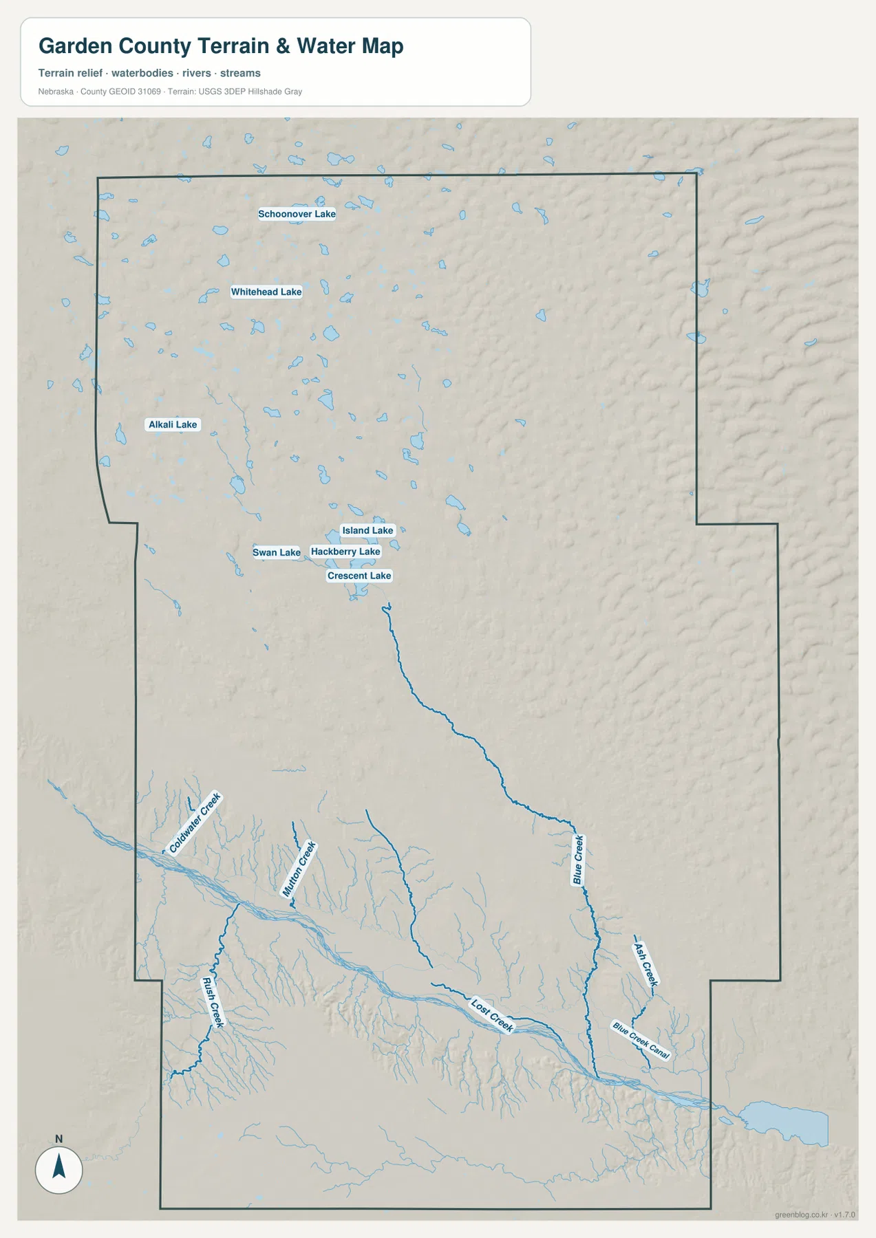
North Platte River is the dominant water feature across southern Garden County. Its broad valley passes through the Oshkosh and Lewellen area, receiving numerous tributaries from the surrounding uplands. Lost Creek, Blue Creek, Ash Creek, Rush Creek, and Coldwater Creek are among the named channels visible on the supplied map.
The northern water landscape is completely different. Schoonover Lake, Whitehead Lake, Alkali Lake, Crescent Lake, Island Lake, Hackberry Lake, and Swan Lake are scattered through the Sandhills. These shallow water bodies occupy low basins between dunes rather than one continuous river valley.
U.S. Fish and Wildlife Service says Crescent Lake National Wildlife Refuge lies north of Oshkosh at the southwestern end of the Nebraska Sandhills. The refuge protects a complex of shallow lakes, marshes, seasonal wetlands, wet meadows, and prairie, illustrating why the northern county contains so many mapped water bodies despite its dry-looking grassland setting.
This water map is intended for geographic reference. It does not define flood zones, legal water rights, parcel boundaries, current lake levels, channel depth, navigability, or public access. Those questions require current information from USGS, U.S. Fish and Wildlife Service, and the responsible local agencies.
The North Platte valley lies more than 270 meters below the highest uplands
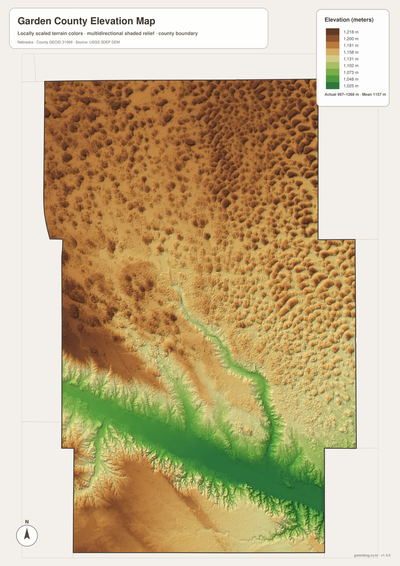
The elevation map reports an actual county-wide range of approximately 997 to 1,268 meters, with a mean near 1,157 meters. The lowest dark-green terrain follows North Platte River across the south. Oshkosh and Lewellen occupy this broad low corridor, which is clearly separated from the higher Sandhills to the north.
The highest brown terrain appears across parts of the north and northwest and in some uplands south of the river. The Sandhills are not a smooth plateau: closely spaced dunes and interdunal basins create constant small-scale relief changes. Total county relief is about 271 meters.
Crescent Lake and neighboring wetlands sit in lower Sandhills basins, while tributary valleys descend toward the North Platte. Near the river, steep bluff and canyon transitions are especially clear. Ash Hollow is one of the best-known examples of a route dropping from higher plains into the North Platte Valley.
The elevation colors are scaled locally for Garden County and should be used to compare locations within this map. Similar shades on another county map may represent different absolute heights. The generalized surface is not survey-grade information for engineering, construction, drainage design, or property work.
Garden County separated from Deuel County in 1909
Garden County’s official history says residents voted in 1909 to create a new county from the northern part of Deuel County. The Nebraska Association of County Officials gives the same year for authorization and organization. Oshkosh became the county seat when the new county government was established.
The modern landscape still reflects the county’s two economic zones. Garden County describes the north as cattle-ranching country, while productive farming occupies the North Platte River Valley. The maps show that contrast directly: northern roads cross broad Sandhills with few towns, while the southern valley contains the main population and transportation corridor.
Ash Hollow preserves a dramatic descent from the plains to the river valley
Ash Hollow State Historical Park lies southeast of Lewellen and is one of Garden County’s best-known historic landscapes. Nebraska Game and Parks says sweet spring water made the hollow an important stop on the Oregon and California trails, and deep wagon ruts remain visible on Windlass Hill.
History Nebraska describes Ash Hollow as a major canyon descending into the North Platte Valley. The elevation map helps explain why emigrant traffic concentrated there: travelers moving across high plains needed a practical route down the steep bluff country to the lower river corridor. The park also preserves evidence of much earlier Indigenous use of the area.
Use Oshkosh and North Platte River as the two easiest map anchors
For basic orientation, start at Oshkosh and follow U.S. 26 east toward Lewellen or west toward Lisco. Then identify Highways 27 and 92 to organize the southern road network. Road 181 provides a useful northward reference into the much more sparsely settled Sandhills.
For physical geography, begin with North Platte River and move north through the tributary valleys into the Crescent Lake and Whitehead Lake area. The elevation map shows the same transition as low green river country rises into higher brown Sandhills with numerous small wet basins.
The downloadable high-resolution JPG files are especially useful when small road numbers, creek names, and lake labels are difficult to read in the web previews. Start with the Oshkosh-Lewellen corridor and then compare the river, northern wetlands, and elevation surface to see how settlement follows the county’s strongest physical contrast.
Frequently Asked Questions
Does the city map show the distance between Oshkosh and Lewellen?
No. The supplied city map ranks and locates Oshkosh and Lewellen, but it does not include a connector line or mileage value. Use U.S. 26 on the road map for relative position and a current routing service when actual driving distance is needed.
Where is the lowest terrain in Garden County?
The North Platte River valley across the southern county contains the lowest broad terrain. The mapped elevation range is about 997 to 1,268 meters, and terrain generally rises away from the river into the Sandhills and other uplands.
Why are there so many lakes in northern Garden County?
Northern Garden County lies within the Nebraska Sandhills, where shallow basins between grass-covered dunes hold lakes, marshes, wet meadows, and seasonal wetlands. Crescent Lake National Wildlife Refuge protects a representative part of this wetland-rich landscape.
Map File Information
The ZIP contains the original high-resolution JPG files for the Garden County boundary and road map, city distribution map, terrain and water map, and elevation map.
- Included Files: Use only the versions confirmed in the article and supplied images
- File Type: Use the confirmed download contents
- Intended Use: Printing, education, presentations, and map-based projects
Related Maps
Sources and references
- Garden County – About Our County
- Nebraska Association of County Officials – Garden County
- Nebraska Game and Parks – Ash Hollow State Historical Park
- U.S. Fish and Wildlife Service – Crescent Lake National Wildlife Refuge
- USGS National Hydrography
- USGS 3D Elevation Program
These maps are intended for geographic reference. For legal boundaries, land ownership, flood determinations, water rights, road conditions, construction, surveying, or other decisions requiring current authoritative information, consult Garden County and the responsible state or federal agency.
Green Map creates custom-edited map images using open geographic data sources such as geoBoundaries, Natural Earth, OpenStreetMap, and government open data. These maps are edited visual materials, not raw data files, and are provided for education, documents, presentations, and graphic reference.