Dawes County occupies the northwestern Nebraska Panhandle, where Chadron sits between the lower White River country to the north and the much higher Pine Ridge terrain to the south. Crawford and Whitney lie west of Chadron along the U.S. 20 corridor, while the southern half is dominated by ridges, canyons, forests, and long creek valleys. The contrast between those two landscapes is the county’s most obvious map feature. High-resolution map files are available for download in the section below.
This page explains the principal towns and roads, straight-line connections from Chadron, the White and Niobrara river systems, named creeks and reservoirs, and an elevation range of about 928 to 1,474 meters. The original high-resolution JPG versions of the supplied maps can also be downloaded together in a ZIP for printing, classroom use, or personal reference.
Table of Contents
Chadron sits between the northern lowlands and the Pine Ridge escarpment
Chadron is the Dawes County seat and the best reference point for reading the map. The county courthouse and main government offices are based there, and the city sits near the junction of U.S. 20 and U.S. 385. That makes Chadron a practical starting point for Crawford and Whitney to the west as well as the high country and recreation areas to the south.
Dawes County was separated from Sioux County in 1885 and named for Nebraska Governor James W. Dawes. History Nebraska records that Chadron was first designated the temporary county seat, then competed against Dawes City, today’s Whitney, in the June 1885 election for the permanent seat. Chadron prevailed and has remained the administrative center.
The county reaches Sioux County on the west, Box Butte County on the south, and Sheridan County toward the northeast. The southern boundary is comparatively straight, but the interior is strongly shaped by river and creek valleys. Moving south from Chadron, the terrain quickly becomes more rugged as Pine Ridge ridges and canyons replace the lower northern landscape.
U.S. 20 links Crawford, Whitney, and Chadron across the north
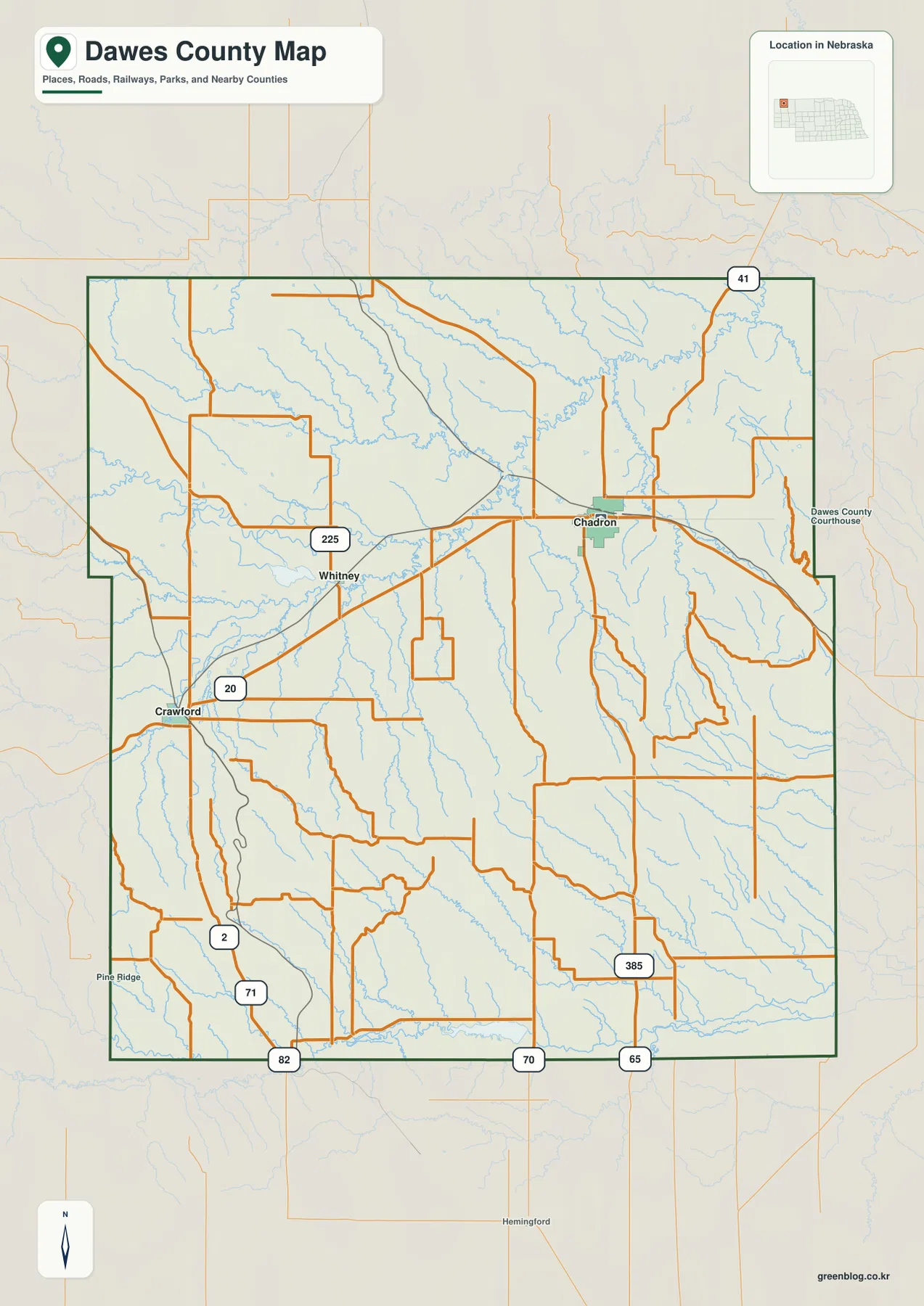
U.S. 20 is the simplest east-west reference. It runs from Crawford through the Whitney area and continues to Chadron before leaving the county to the east. The three principal communities therefore line up along the same northern transportation corridor, making the county’s settlement pattern easy to understand.
U.S. 385 turns south from Chadron and climbs toward Pine Ridge and Chadron State Park. Around Crawford, routes marked 2 and 71 provide additional north-south connections, while 225 appears near Whitney. Route 41 is visible in the northeast, and roads marked 82, 70, and 65 cross the southern edge of the county.
Roads are generally more open across the lower north, but they bend more often in the southern high country because ridges and narrow drainage valleys interrupt direct routes. The county map is useful for orientation, while current construction, closures, unpaved segments, and actual driving time should be checked with live Nebraska transportation information.
Whitney is 13 direct miles from Chadron, Crawford 23
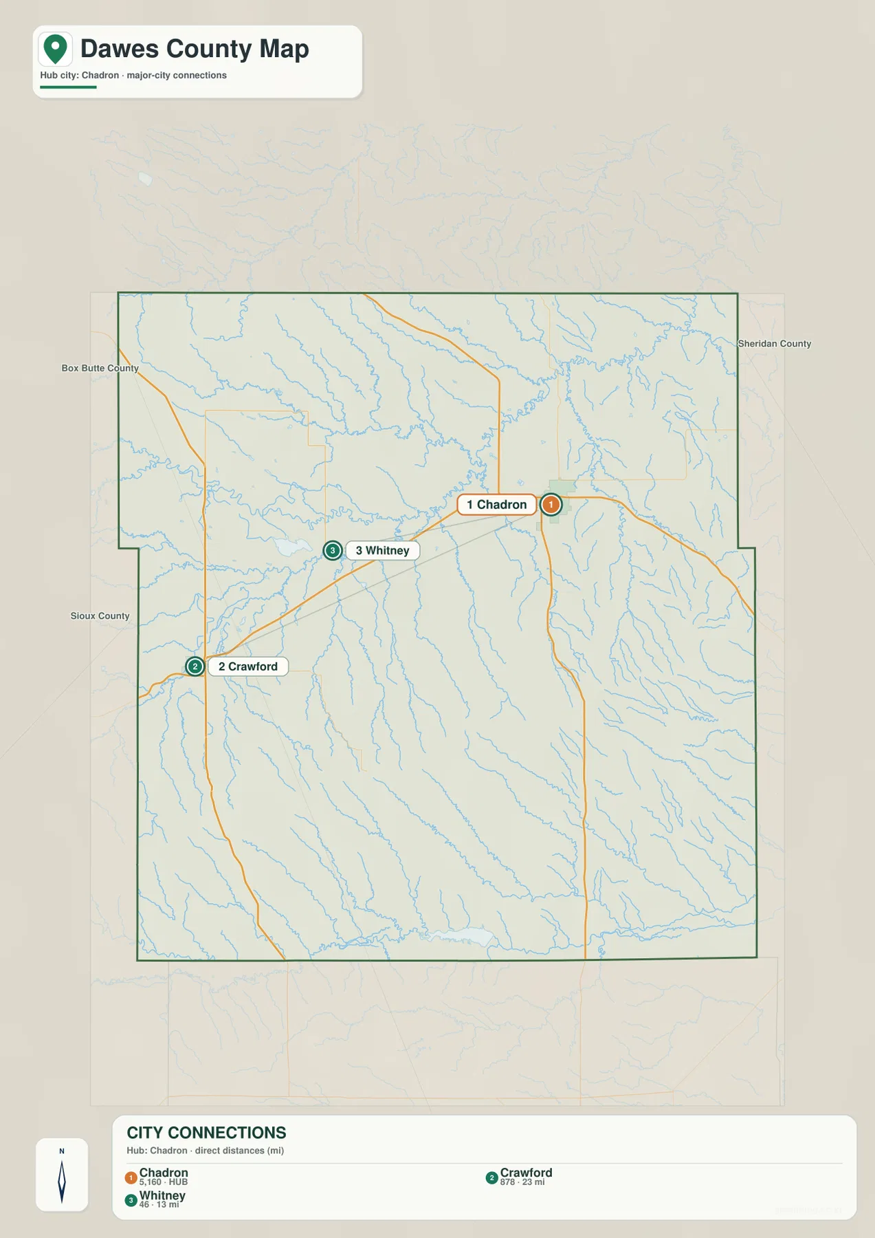
The city-connection map uses Chadron as the hub. It shows approximately 13 straight-line miles to Whitney and 23 miles to Crawford. These are direct point-to-point measurements rather than road mileage, so actual driving distances depend on the route and the exact starting and ending locations.
Whitney lies west of Chadron close to U.S. 20, while Crawford is farther west-southwest along the same general corridor. The two connectors therefore point in similar directions and emphasize how the county’s principal communities cluster across the northern third rather than the rugged south.
The values printed on the supplied city map are 5,160 for Chadron, 878 for Crawford, and 46 for Whitney. They are part of the supplied ranked-city graphic rather than a continuously updated demographic table. Current population figures should be checked with the U.S. Census Bureau or another authoritative source when needed.
White River drains the north while the Niobrara follows the southern edge
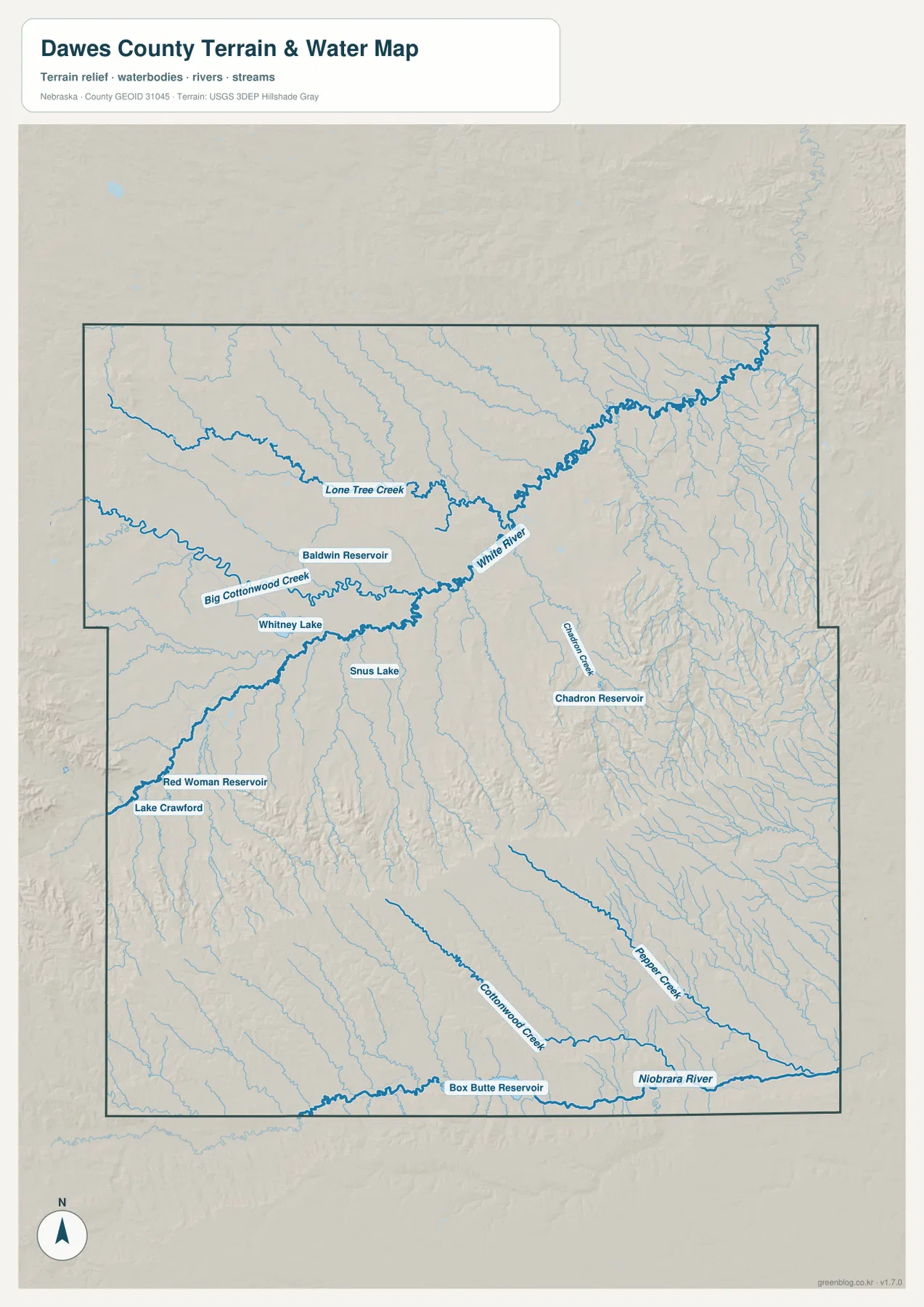
The White River is the most prominent watercourse across the northern interior. It runs from the west-central side toward the northeast, receiving Lone Tree Creek and Big Cottonwood Creek from higher ground. Whitney Lake and Baldwin Reservoir appear close to this drainage, providing additional landmarks in the lower northern part of the county.
South of Chadron, Chadron Creek cuts into the Pine Ridge terrain and passes close to Chadron Reservoir. Nebraska Game and Parks notes that Chadron Creek also runs through Chadron State Park, where steep buttes, wooded slopes, and canyons create one of Nebraska’s most distinctive landscapes.
Along the southern edge, the Niobrara River forms another major drainage line. Cottonwood Creek and Pepper Creek descend through the high southern terrain toward that side of the county. Near Crawford, Red Woman Reservoir and Lake Crawford are labeled, while Snus Lake appears farther east. Box Butte Reservoir lies just beyond the southern boundary.
This water map is intended for geographic reference. It does not define flood zones, legal water rights, parcel boundaries, reservoir levels, channel depth, navigability, or public access. Those questions require current information from USGS and the appropriate local or state agencies.
More than 500 meters separate the northern lowlands from Pine Ridge high ground
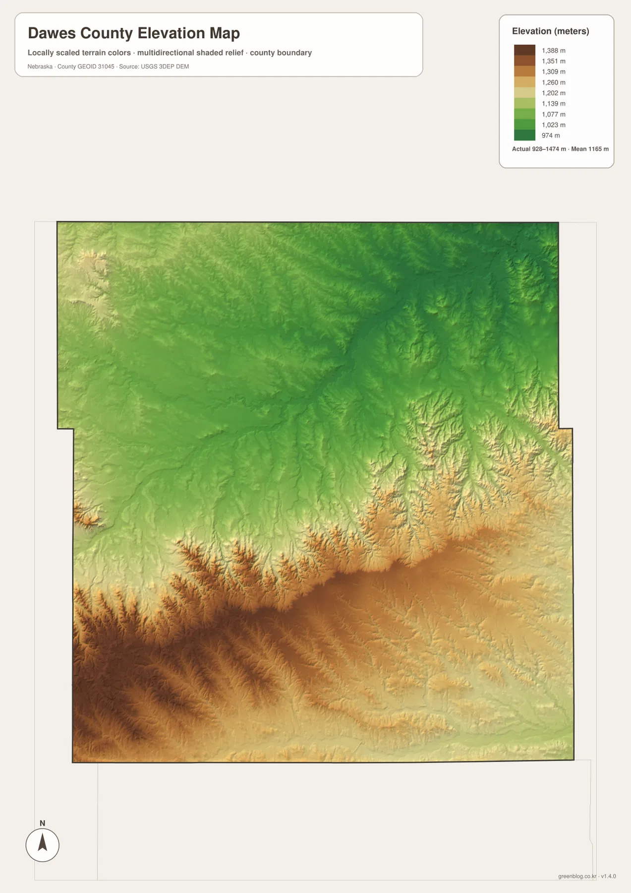
The elevation map reports an actual county-wide range of approximately 928 to 1,474 meters, with a mean near 1,165 meters. Greens dominate the north and northeast, including the White River valley, while tan and brown terrain increases rapidly toward the south and southwest.
The highest ground is concentrated in the southwestern Pine Ridge country. Long ridges and steep canyon walls create sharp local relief rather than one single mountain mass. A high east-west belt also extends through the south-central county, where creeks cut deeply into the elevated terrain.
The northern third is generally lower and smoother, although the White River and tributaries still carve narrow valleys. Chadron lies close to the transition between the lower north and the high ridge country. Traveling south on U.S. 385 toward Chadron State Park therefore involves a noticeable climb that is easy to see on the elevation map.
The elevation colors are scaled locally for Dawes County and should be used to compare locations within this map. Similar shades on another county map may represent different absolute heights. The generalized surface is not survey-grade information for engineering, construction, drainage design, or property work.
Chadron State Park puts the Pine Ridge terrain on display
Nebraska Game and Parks says Chadron State Park was established in 1921 as Nebraska’s first state park. It sits south of Chadron in the Pine Ridge among distinctive buttes and canyons, with ponderosa pine forest and Chadron Creek adding to the landscape. U.S. 385 provides the main road connection from Chadron.
The park and adjacent Nebraska National Forest lands include extensive hiking and biking opportunities, making them useful real-world references for the high relief shown on the map. This county map is not a trail guide, however, so current trail conditions, campground information, fire restrictions, and seasonal closures should be checked on the official park page.
County formation and railroad growth established Chadron as the regional center
Dawes County’s official history says the area belonged to Sioux County after 1877 and was separated in 1885. Box Butte County was later carved from Dawes, leaving the county with its present area. The same history describes earlier Oglala and Brule presence, followed by trappers, fur traders, ranchers, homesteaders, and railroad settlement.
History Nebraska records that Chadron became the permanent county seat in 1885 during the same period that railroad towns were developing across northwestern Nebraska. Crawford also grew with the railroad and the transportation network around Fort Robinson. Today’s U.S. 20 corridor between Chadron, Whitney, and Crawford still reflects that northern settlement history.
Use U.S. 20 and Pine Ridge as the two main map anchors
For basic orientation, locate Chadron first and follow U.S. 20 west through Whitney to Crawford. Then use U.S. 385 to move south toward Chadron State Park and the Pine Ridge high country. The city-connection map simplifies the same northern settlement pattern with direct distances from Chadron.
For physical geography, begin with White River, Big Cottonwood Creek, and Lone Tree Creek in the north, then move south through Chadron Creek, Cottonwood Creek, and Pepper Creek to the Niobrara River. The elevation map explains the same transition by showing green northern lowlands and much higher brown terrain across the south and southwest.
For printing or classroom display, the downloadable high-resolution JPG files preserve more road labels, creek names, and reservoir detail than the web previews. The county map emphasizes roads and settlements, the city map shows Chadron-centered direct distances, the water map highlights the river-and-reservoir network, and the elevation map shows the strong north-to-south relief change.
Frequently Asked Questions
Are the distances from Chadron to Whitney and Crawford driving distances?
No. The city map shows straight-line distances of about 13 miles to Whitney and 23 miles to Crawford. Actual driving mileage depends on the road used and the exact starting and ending points.
Where is the highest terrain in Dawes County?
The highest ground is concentrated in the southwestern Pine Ridge and along elevated terrain across the southern half. The county-wide elevation range is about 928 to 1,474 meters, while the north and northeast are generally lower.
Can the water map be used for flood or property decisions?
No. It is a geographic reference showing White River, Niobrara River, Big Cottonwood Creek, Chadron Creek, and several lakes and reservoirs. Flood risk, water rights, parcel boundaries, channel conditions, and access questions require current authoritative records.
Map File Information
The ZIP contains the original high-resolution JPG files for the Dawes County boundary and road map, city-connection map, terrain and water map, and elevation map.
- Included Files: Use only the versions confirmed in the article and supplied images
- File Type: Use the confirmed download contents
- Intended Use: Printing, education, presentations, and map-based projects
Related Maps
Sources and references
- Dawes County – Mission & History
- History Nebraska – Dawes County Historical Note
- Nebraska Game and Parks – Chadron State Park
- U.S. Census Bureau TIGER/Line Shapefiles
- USGS National Hydrography
- USGS 3D Elevation Program
These maps are intended for geographic reference. For legal boundaries, land ownership, flood determinations, water rights, road conditions, construction, surveying, or other decisions requiring current authoritative information, consult Dawes County and the responsible state or federal agency.
Green Map creates custom-edited map images using open geographic data sources such as geoBoundaries, Natural Earth, OpenStreetMap, and government open data. These maps are edited visual materials, not raw data files, and are provided for education, documents, presentations, and graphic reference.