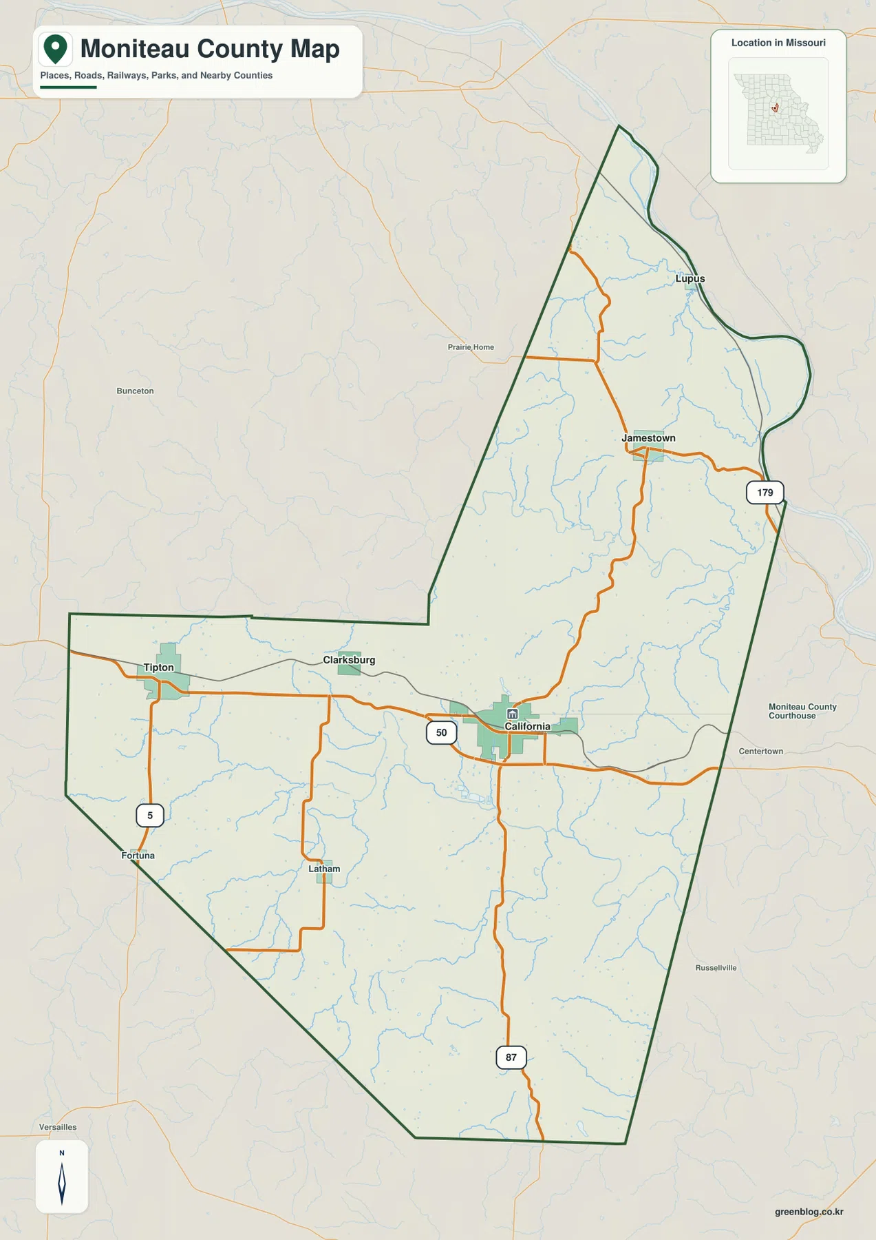
Moniteau County sits in central Missouri with California serving as the main road and settlement reference point. U.S. 50 crosses the county through California and Tipton, Route 87 heads south from California, and Route 179 reaches north toward Jamestown and the Missouri River side of the county. The northern and northeastern boundary follows broad bends of the Missouri River, while the southwest is defined by much straighter county lines and rolling uplands. High-resolution map files are available for download in the section below.
The maps on this page separate those features into a general county view, a simplified city-connections map, a terrain-and-water map, and an elevation map. High-resolution JPG originals of all four are available together in one ZIP, which is useful when the WebP previews are too small for detailed inspection or A3 printing.
Table of Contents
California anchors the county’s road network
California is the easiest place to begin reading the general map because several of the county’s clearest routes meet there. U.S. 50 runs east-west through the city toward Tipton on one side and the Cole County direction on the other. Route 87 leaves California to the south and continues toward the lower county line, while the road north toward Jamestown eventually connects with Route 179 in the narrower northeastern part of the county.
Tipton lies near the western side of the county along the U.S. 50 corridor, with Clarksburg between Tipton and California but slightly farther north. Latham and Fortuna provide useful references in the southwest where the road pattern becomes more rural. North of California, Jamestown occupies a central position in the long upper section of the county, and Lupus sits much closer to the Missouri River at the northern end.
The shape of Moniteau County changes noticeably from one side to the other. Long straight and diagonal boundary segments define much of the west and south, but the north and northeast bend with the Missouri River. Near Lupus, the county narrows as the river curves around the edge, making the upper section look almost like a long neck attached to the wider southern half.
Straight-line city connections radiate from California
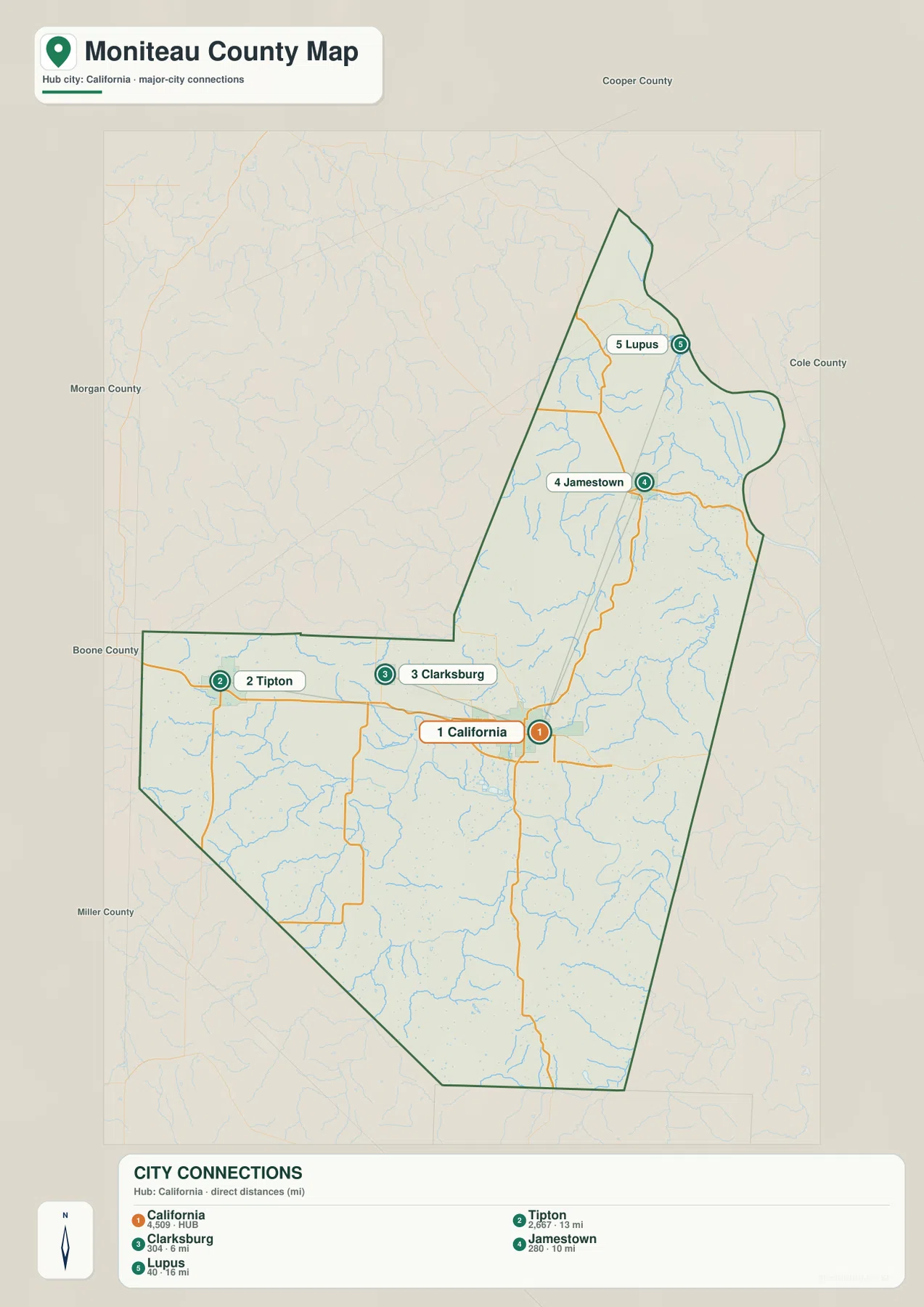
The city-connections map uses California as its hub and reduces the county to five prominent settlement references. Clarksburg is the closest of the labeled places at about 6 miles in a straight line from California. Jamestown is shown at roughly 10 miles, Tipton at about 13 miles, and Lupus at about 16 miles. Those numbers are direct point-to-point distances, not driving mileage, so the actual road trip can be longer.
The arrangement is as useful as the numbers. California and Tipton line up broadly along the U.S. 50 corridor, while Jamestown and Lupus extend north into the narrow upper part of the county. Clarksburg sits between California and Tipton but slightly to the north, which makes it a helpful intermediate reference when moving between the western and central portions of the map.
South of California, there are fewer equally prominent city labels on this simplified map and the landscape is dominated more by roads, creeks, and ridges. That difference helps explain why a city-only view is most useful for the central and northern half, while the terrain and elevation maps add more information in the south. The city map is therefore best treated as an orientation tool rather than a route planner.
Missouri River bends and a dense network of creek valleys
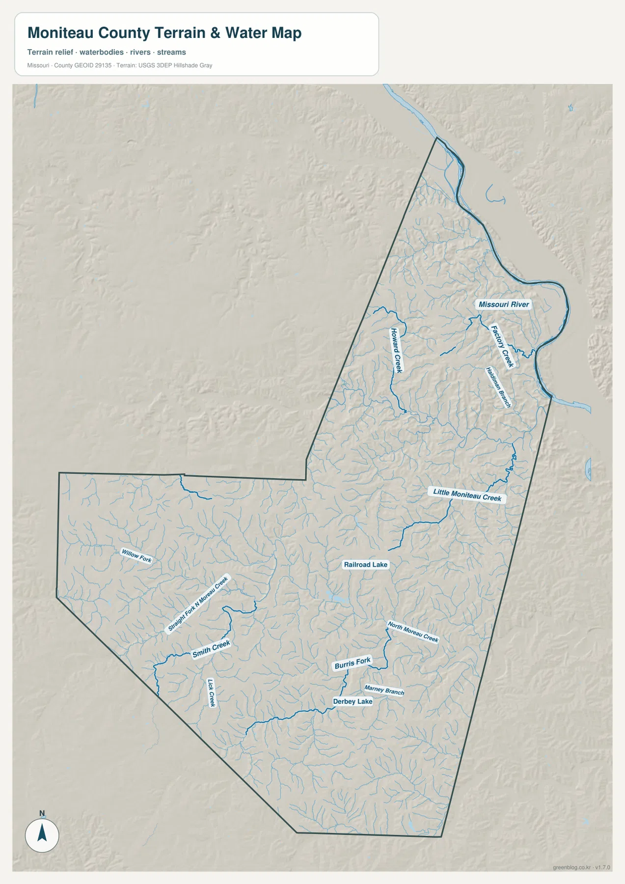
The terrain-and-water map is dominated by the Missouri River along the northern and northeastern edge. Factory Creek and Hardiman Branch occupy short valleys near the river, while Howard Creek runs through a longer interior valley farther west. Together they show how the upper county drains toward the large river rather than forming a single broad, flat watershed.
Little Moniteau Creek is one of the clearest interior waterways on the eastern side. Farther south, North Moreau Creek connects with Burris Fork and smaller branches around Derbey Lake, while Railroad Lake appears near the center of the county. In the southwest, Smith Creek, Lick Creek, Straight Fork N Moreau Creek, and Willow Fork occupy separate branching valleys that cut through the higher uplands.
This pattern of many narrow tributaries is important because it matches the relief visible on the elevation map. The county is not a broad plain between California and the Missouri River; instead, ridges are repeatedly divided by small creek valleys. The water map is intended for geographic reference only and should not be used as a flood-risk map, depth chart, navigation product, parcel map, or legal boundary survey.
Relief rises from 167 meters in the river valleys to nearly 296 meters
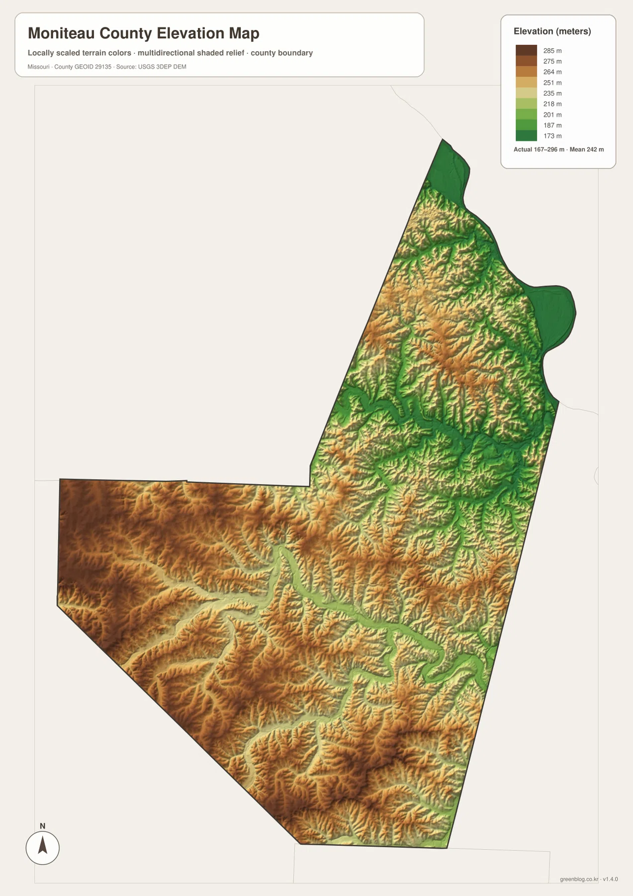
The elevation map reports an actual range of about 167 to 296 meters and a mean near 242 meters. The lowest greens follow the Missouri River and the larger creek valleys, while warmer tan and brown colors mark higher ridges across the west and southwest. The broad elevation range is large enough to make the drainage network visible even without labels because the low valleys carve distinct green paths through the uplands.
The northeastern river margin is the flattest and lowest part of the county, but the land rises quickly away from the Missouri River. South of Jamestown and around Little Moniteau Creek, narrow low corridors wind through higher ridges. The southwest has more extensive high ground, especially south of Tipton and toward the Miller County side, where brown uplands cover a larger share of the map.
Comparing the water and elevation maps makes the relationship especially clear. Many of the green valleys correspond directly to labeled creeks, while the higher ridges occupy the spaces between them. This is a generalized county-scale elevation surface, so it is appropriate for comparing broad patterns but not for engineering design, drainage construction, property-level elevation decisions, or any task requiring survey-grade measurements.
Pick the map that matches the question you are trying to answer
The general county map is the best starting point for roads and settlement locations. It shows how California relates to Tipton, Jamestown, Lupus, U.S. 50, Route 87, Route 179, and the county boundary in one view. The city-connections map is cleaner when you only need the relative position of the five highlighted places and their straight-line distances from California.
For rivers, creeks, and drainage patterns, the terrain-and-water map carries more useful detail. Once the major waterways are located there, the elevation map shows why they follow certain corridors and where the surrounding ridges rise. The contrast between the Missouri River lowland and the higher southwestern interior is easiest to understand by comparing those two maps side by side.
The downloadable JPG originals are better suited to large-format viewing than the WebP previews embedded in the article. They can be enlarged for classroom handouts, reports, planning notes, or personal reference without losing as much label detail. These are general reference maps, however, so legal boundaries, property ownership, live traffic conditions, flood status, and site-specific elevation should be verified with the appropriate current official source.
Frequently Asked Questions
Which labeled place is closest to California on the city map?
Clarksburg is the closest highlighted place, shown at about 6 miles from California in a straight line. Jamestown is about 10 miles away, Tipton about 13 miles, and Lupus about 16 miles. These are direct distances rather than driving distances.
Where does the Missouri River form the county boundary?
The Missouri River follows the northern and northeastern edge of Moniteau County. Near Lupus, the county becomes noticeably narrower as the boundary bends with the river, and short tributaries such as Factory Creek and Hardiman Branch descend toward it.
How much elevation change is shown across Moniteau County?
The elevation map shows an actual range of about 167 to 296 meters with a mean near 242 meters. The river and creek valleys are lowest, while broader high ground appears across the western and southwestern uplands.
Map File Information
The download ZIP contains high-resolution JPG versions of the Moniteau County general map, city map, terrain-and-water map, and elevation map.
- File Type: JPG
Related Maps
Sources and References
Boundary and road reference data are supported by U.S. Census Bureau TIGER/Line, water features by USGS National Hydrography, and elevation data by the USGS 3D Elevation Program. Local historical context and confirmation that California is the county seat are available from the Moniteau County Historical Society.
Green Map creates custom-edited map images using open geographic data sources such as geoBoundaries, Natural Earth, OpenStreetMap, and government open data. These maps are edited visual materials, not raw data files, and are provided for education, documents, presentations, and graphic reference.