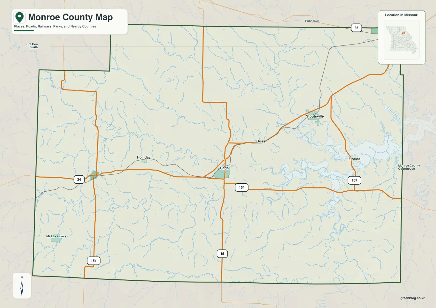
Monroe County lies in northeastern Missouri, where Paris works as the central road reference and the landscape gradually becomes more water-dominated toward the Salt River reservoir country in the east. U.S. 24 crosses Paris from west to east, Route 15 runs south from the county seat, and smaller routes connect Monroe City, Stoutsville, Florida, Holliday, and Madison. The eastern half is shaped by branching Salt River valleys and the large reservoir now widely known as Mark Twain Lake. High-resolution map files are available for download in the section below.
This page separates those features into a county road-and-boundary map, a city-distribution map, a terrain-and-water map, and an elevation map. If you need more detail than the WebP previews provide, all four original high-resolution JPG maps can be downloaded together in one ZIP for close viewing, A3 printing, classroom work, or larger reference documents.
Table of Contents
Paris gives the clearest starting point for the county road network
Paris sits close to the middle of Monroe County and is the county seat, making it the most practical place to orient the general map. U.S. 24 arrives from the west near Holliday, passes through Paris, and continues across the county. Route 15 crosses the same area and runs south toward the county line. Locating those two roads first establishes both the east-west and north-south directions before the smaller routes and waterways are added.
Route 154 leaves the Paris area toward Florida and the reservoir side of the county, while Route 107 serves the eastern interior. Monroe City occupies the northeastern corner close to the broader U.S. 36 corridor, and Stoutsville lies southwest of it along the road network leading back toward Paris. On the western side, Route 151 drops toward the southwest after U.S. 24 enters the county, connecting a more sparsely settled section of rolling countryside.
The county outline is mostly straight along the west, south, and east, but the northwest has a stepped indentation before the boundary turns north again. Neighboring labels for Shelby, Ralls, Marion, Audrain, Randolph, and Macon counties help place Monroe County within northeastern Missouri. The map is especially useful for seeing how Paris links the western road corridor with the more irregular lake-and-stream landscape to the east.
Monroe City, Paris, Madison, and the smaller eastern communities are widely spaced
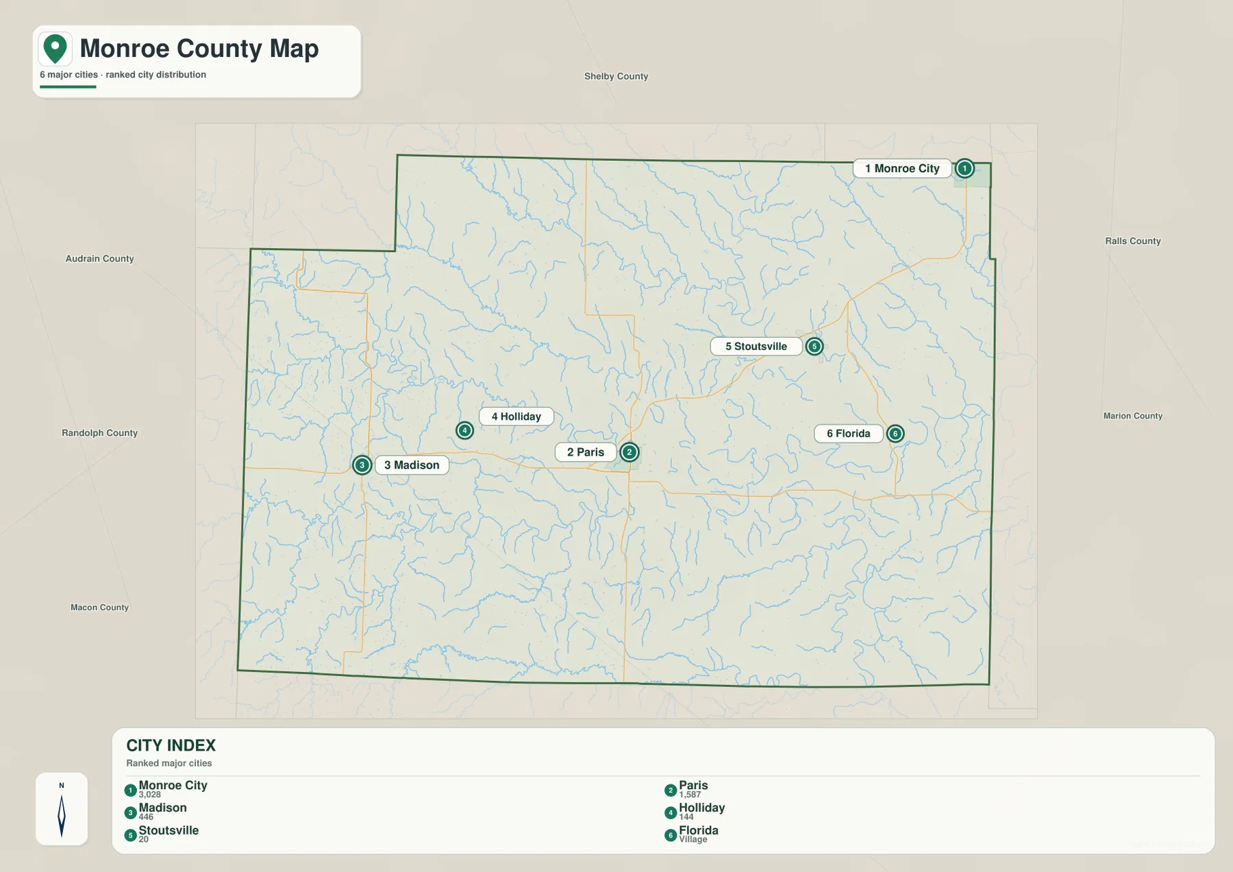
The city map highlights six settlement references: Monroe City, Paris, Madison, Holliday, Stoutsville, and Florida. Monroe City is positioned at the far northeast edge, while Paris is much closer to the geographic center. Madison and Holliday occupy the western half, and Stoutsville and Florida provide two reference points in the east. The pattern is spread across the county rather than concentrated in one continuous urban area.
That distribution matters when switching between maps. Paris and the western communities are surrounded by a relatively open network of roads and smaller streams, whereas Stoutsville and Florida sit closer to the dense tributary system and reservoir shoreline. Monroe City is separated from Paris not only by distance but also by its northeastern position near a different set of roads and county boundaries.
The ranking on the city map is useful as a quick index, but it should not be treated as a travel hierarchy or a statement about current commuting patterns. For navigation, the general road map provides more context. The simplified city view is best for memorizing where the six labeled places sit before moving to the more detailed waterways and terrain.
Four Salt River branches converge toward the eastern reservoir
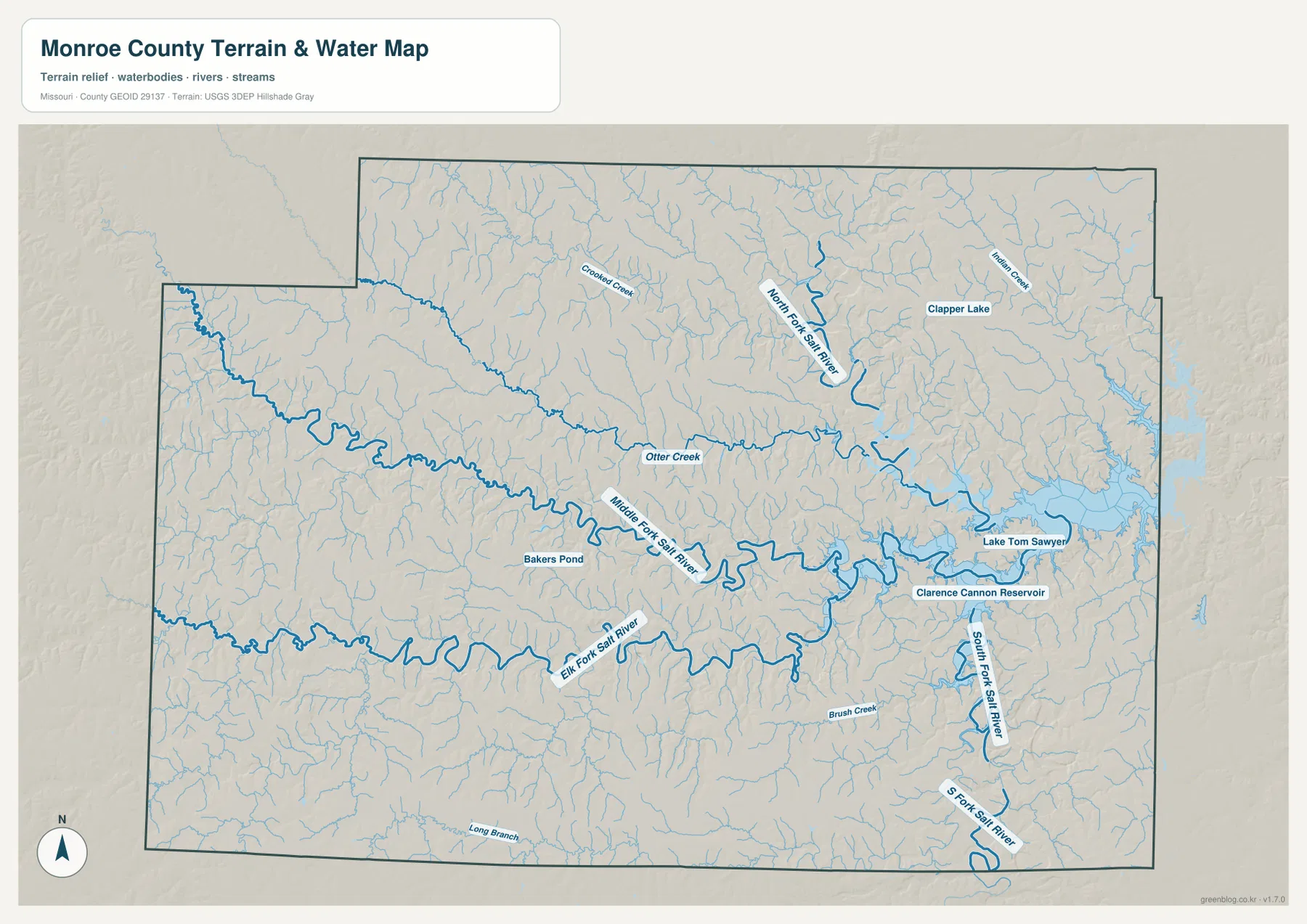
The terrain-and-water map is defined by the Salt River system. North Fork Salt River descends through the northern interior, Middle Fork Salt River crosses the center, Elk Fork Salt River winds through the southern half, and South Fork Salt River approaches the reservoir from the southeast. Otter Creek joins the central drainage, while many shorter tributaries form a dense branching pattern between the larger channels.
The broad water body in the east is labeled Clarence Cannon Reservoir on the supplied map. Current U.S. Army Corps of Engineers and Missouri Department of Conservation pages refer to the same major reservoir as Mark Twain Lake, which spans Monroe and Ralls counties. Its irregular shoreline reaches into several valleys, creating long coves and narrow inlets that make the eastern side of the county look very different from the western uplands.
Smaller features add another layer of detail. Crooked Creek lies in the northwestern interior, Indian Creek appears in the northeast, Brush Creek crosses the lower east, and Long Branch is labeled near the southern edge. Clapper Lake and Bakers Pond are also visible. These names are helpful for geographic reference, but the map is not designed to determine flood risk, water depth, navigability, or legal property boundaries.
Relief falls from western ridges into Salt River valleys and the lake basin
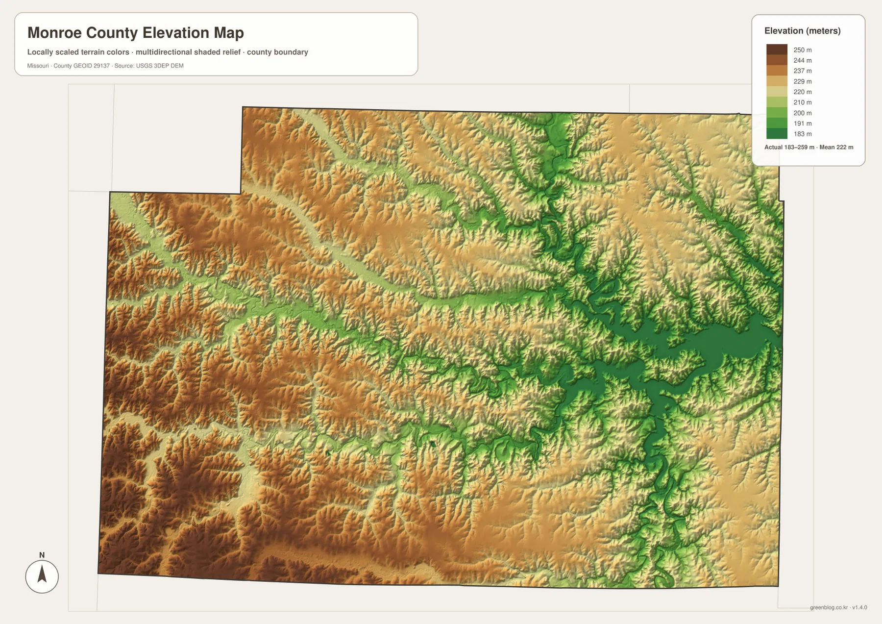
The elevation map shows an actual range of about 183 to 259 meters, with a mean near 222 meters. Browns and darker tans dominate much of the west and southwest, indicating broad higher ridges. Greens become more extensive toward the east, especially along the Salt River channels and around the reservoir. The result is not a simple smooth slope but a dissected landscape in which narrow valleys cut repeatedly through the uplands.
North Fork and Middle Fork Salt River stand out as long green corridors that branch into many smaller ravines. Between them, ridges remain higher and appear yellow or brown. The Elk Fork and South Fork valleys repeat the same pattern farther south, while the reservoir basin widens the low ground and creates a larger continuous green area near the eastern edge.
The western and southwestern sections show the most persistent higher ground. Areas south of Madison and toward the Macon and Randolph county sides contain larger blocks of dark tan and brown relief, while the Stoutsville–Florida side is more broken by low stream corridors. Comparing the water and elevation maps makes this relationship straightforward: most of the green lowland bands align with named streams, and the higher ridges occupy the ground between them.
This elevation surface is intended for county-scale comparison, not survey or engineering work. It can show whether one broad part of the county is generally higher or lower than another, but it should not be used for building design, drainage construction, property-level elevation decisions, or any task that requires precise measurements at a single location.
Use the road map for orientation and the water–elevation pair for terrain
The general county map is the best first choice when the goal is to locate Paris, Monroe City, Madison, Florida, or the major numbered highways. It keeps the settlement names, roads, county outline, and neighboring areas in one view. The city map removes most of that detail and is more useful when you only need to remember how the six highlighted communities are distributed across the county.
For the eastern lake country, the terrain-and-water map provides the clearest explanation. It shows how North Fork, Middle Fork, Elk Fork, and South Fork Salt River approach the reservoir and where smaller creeks occupy the spaces between them. Switching to the elevation map then shows why those channels follow narrow green corridors and why the western half contains broader higher ridges.
The downloadable JPG originals are 3638×2572 pixels each, so they are better suited to enlargement than the embedded previews. They work well for large reference sheets, classroom materials, reports, and personal map collections. Because these are general-purpose maps, current road conditions, legal boundaries, parcel ownership, flood determinations, and site-specific elevations should be checked with the appropriate official source.
Frequently Asked Questions
Why is Paris a useful starting point on the Monroe County map?
Paris is the county seat and lies near the center where U.S. 24 and Route 15 meet. From that crossroads it is easy to follow the western communities, the road toward Florida and the reservoir, or the northbound routes toward Monroe City and Stoutsville.
Are Clarence Cannon Reservoir and Mark Twain Lake the same reservoir?
Yes. The supplied water map uses the Clarence Cannon Reservoir label, while current U.S. Army Corps of Engineers and Missouri Department of Conservation resources commonly call the reservoir Mark Twain Lake. It spans parts of Monroe and Ralls counties.
Where is the lowest terrain concentrated?
The lowest colors follow the Salt River branches and expand around the eastern reservoir basin. Higher ground is more common in the west and southwest. The elevation map reports an overall county range of about 183 to 259 meters.
Map File Information
The download ZIP contains high-resolution JPG versions of the Monroe County general map, city map, terrain-and-water map, and elevation map.
- File Type: JPG
Related Maps
Sources and References
County background and confirmation that Paris is the county seat are available from the official Monroe County website and the City of Paris website. Reservoir information is available from the U.S. Army Corps of Engineers Mark Twain Lake project and the Missouri Department of Conservation. Boundary and road reference data are supported by U.S. Census Bureau TIGER/Line, with water and elevation references from USGS National Hydrography and the USGS 3D Elevation Program.
Green Map creates custom-edited map images using open geographic data sources such as geoBoundaries, Natural Earth, OpenStreetMap, and government open data. These maps are edited visual materials, not raw data files, and are provided for education, documents, presentations, and graphic reference.