Madison County in northwestern Arkansas is a deeply dissected Ozark county centered on Huntsville. Download the four high-resolution JPG maps on this page as one ZIP file. They include the county road map, city-connections map, terrain and water map, and elevation map. Long ridges, narrow creek valleys, and several important headwater systems shape the county. Hindsville lies to the west, Kingston to the east, and St. Paul far to the south, with most of the space between them occupied by rural mountain terrain rather than large towns. The water map shows Kings River, War Eagle Creek, White River, and East Prong White River draining different parts of the county, while the elevation map spans roughly 334 to 766 meters.
Huntsville is the county seat and the best reference point for reading the maps. The Encyclopedia of Arkansas describes Madison County as a rural part of the Arkansas Ozarks, with the Boston Mountains extending across the southern part of the county. That broad description matches the supplied elevation map closely. Huntsville occupies a somewhat wider valley setting, while the south and southeast rise into more tightly packed ridges. Even the northern half remains strongly rolling, with streams cutting through almost every section of the county.
Table of Contents
Huntsville divides the main road routes toward Kingston, Wesley, and St. Paul
The general county map places Huntsville near the central-northern part of Madison County, with several roads spreading outward. Routes 412 and 68 head east toward the Kingston side, and Route 21 continues along the eastern edge. Route 127 runs south from the Huntsville area into higher country, while Routes 23, 6, and 342 serve the St. Paul side farther south. Starting at Huntsville and following these eastbound and southbound routes is the simplest way to understand the main interior road pattern.
The western side has a different set of road references. Route 74 reaches the Wesley area, Route 303 follows the western interior, and Routes 45, 465, and 12 appear around the Hindsville side in the northwest. These roads rarely form a straight grid. They bend around hills and follow lower valleys, which becomes especially obvious when the general map is compared with the elevation layer. Road curvature is one of the clearest visual reminders that nearly the entire county is shaped by rugged Ozark relief.
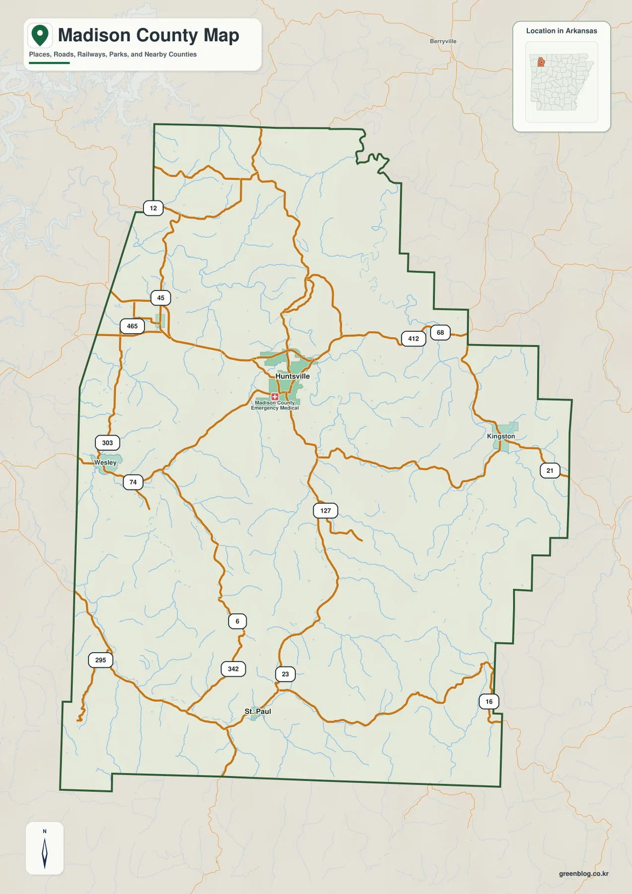
The county boundary is also distinctive. Long stair-step segments appear along the north and east, the western side angles inward toward the south, and the southern boundary is straighter except for a small southwestern projection. Carroll County is labeled to the north, Newton County to the east, Johnson and Crawford counties to the southeast, Franklin County to the southwest, and Washington County to the west. That surrounding context places Madison County firmly inside the mountainous interior of northwestern Arkansas.
The Huntsville hub map shows 8 miles to Hindsville and 19 miles to St. Paul
The city-connections map uses Huntsville as the hub and gives direct point-to-point distances to Hindsville and St. Paul. Hindsville is shown about 8 miles west of Huntsville, while St. Paul is about 19 miles to the south. These are straight-line distances rather than driving mileage. In a county with winding mountain roads, the distinction matters because a road trip may cover considerably more ground than the direct distance shown between the points.
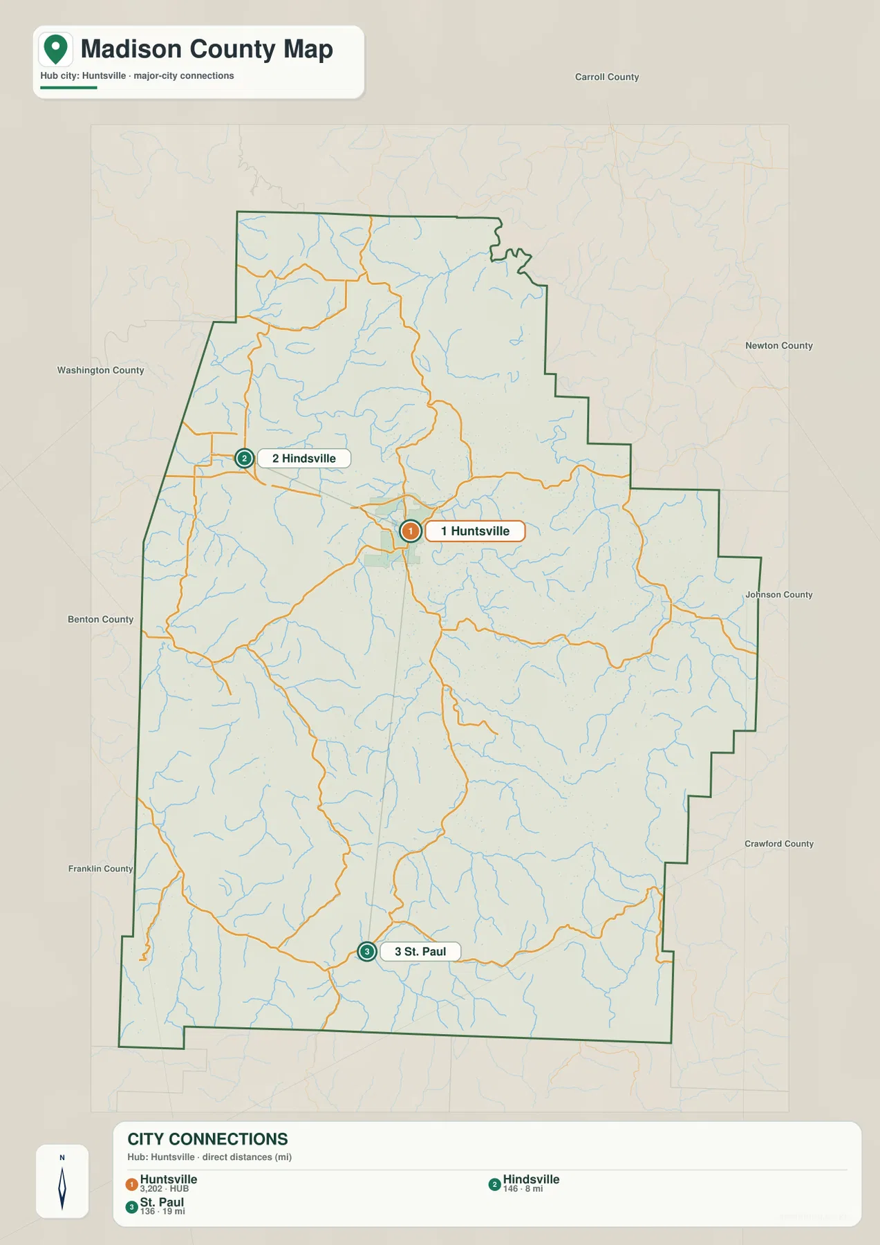
The two connections also point into different parts of the landscape. Hindsville sits in the northwestern road network, where long rolling ridges are cut by smaller creeks. St. Paul is much farther south near the White River and East Prong White River side, where the surrounding highlands are steeper and more closely packed. Comparing the city map with the elevation map turns a simple distance diagram into a useful explanation of how differently the western and southern parts of Madison County are arranged.
The city legend includes numeric values next to the community names, but this article does not reinterpret those figures as current population estimates. The supplied map clearly supports Huntsville as the hub and the two direct distances. Huntsville’s status as county seat comes from separate county-specific reference information.
Kings River, War Eagle Creek, and White River drain separate Ozark valleys
Kings River is the most prominent labeled waterway on the eastern side of the terrain and water map. It follows a long, winding valley near the county’s eastern boundary and receives many small tributaries from the surrounding ridges. War Eagle Creek occupies a separate central valley, with Wharton Creek entering from the east. The relationship between these two waterways helps explain much of the terrain between Huntsville and Kingston: high ridges separate long drainage corridors that rarely run in straight lines.
Several named creeks break up the western and central interior. Glade Creek follows a long valley in the west-central area, while Holman Creek lies farther south. Lollars Creek and Jackson Creek appear in the southwestern half, and numerous unnamed tributaries branch between them. The water map is especially useful in Madison County because the stream network is so dense that many of the narrow valleys are hard to understand from the road map alone.
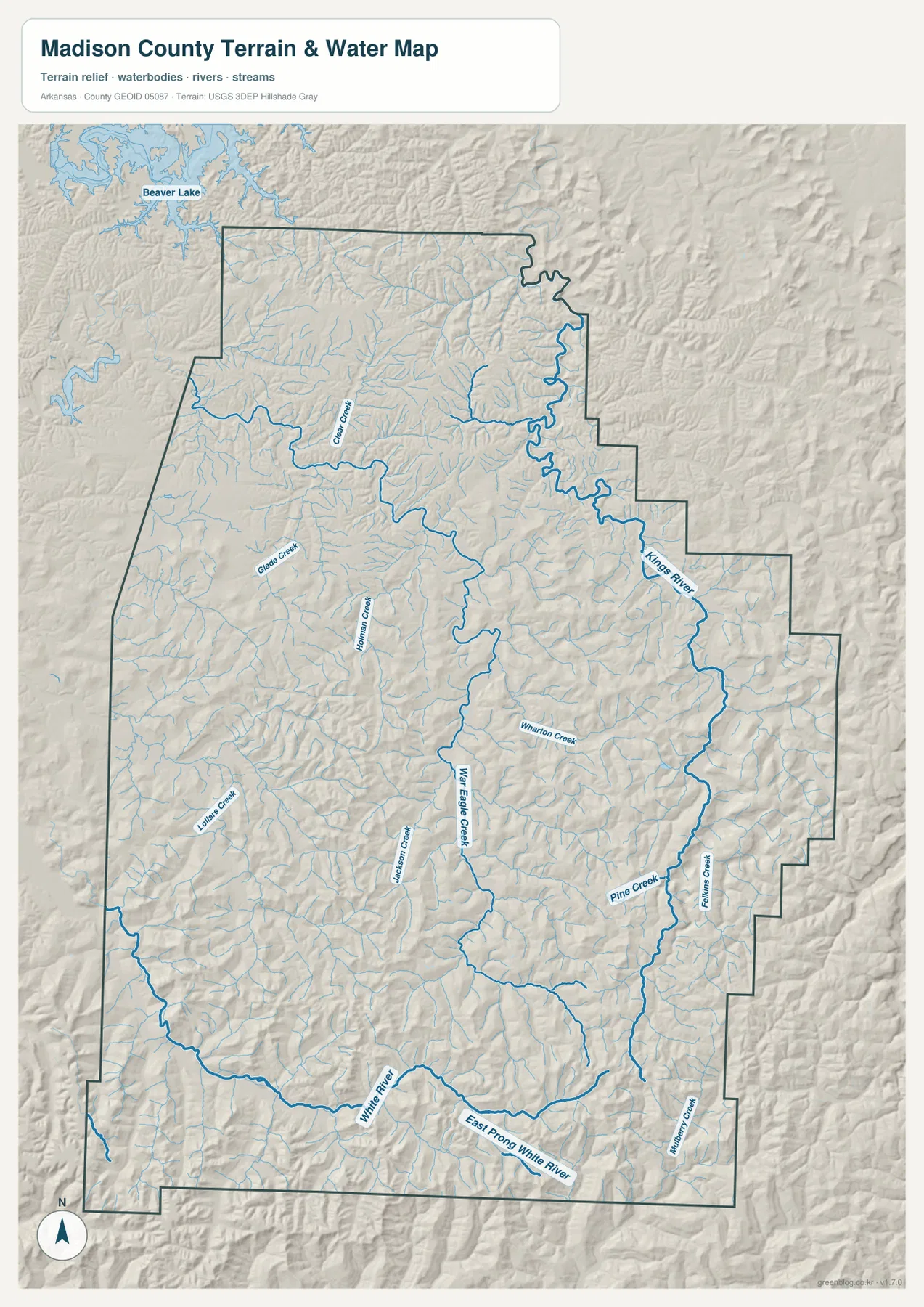
The southern water map is dominated by the White River and East Prong White River, with Pine Creek and Felkins Creek descending through the southeastern mountains. County background sources note that four important waterways—White, War Eagle, Mulberry, and Kings—originate within a few miles of one another in southern Madison County near Boston. Three of those systems are directly visible by name on the supplied map, showing how the southern highlands send water into several different drainage directions.
A portion of Beaver Lake is visible outside the northwestern county boundary, but the interior of Madison County is defined much more by river and creek valleys than by a single large lake. This terrain and water map is intended for general geographic reference. It does not provide current water level, flood risk, whitewater conditions, fishing rules, property boundaries, or live road access. For river recreation or safety decisions, current USGS and agency information should be used.
Elevation rises from about 334 to 766 meters across repeated ridges and deep valleys
The supplied elevation map shows an actual countywide range of about 334 to 766 meters, with a mean near 505 meters. That is roughly 432 meters of relief. The northern half contains broad green and light-green rolling uplands, but the south and southeast become increasingly tan and brown as the ridges rise. The strongest highland pattern appears along the southern Boston Mountain side, where narrow valleys are packed between long, steep ridges.
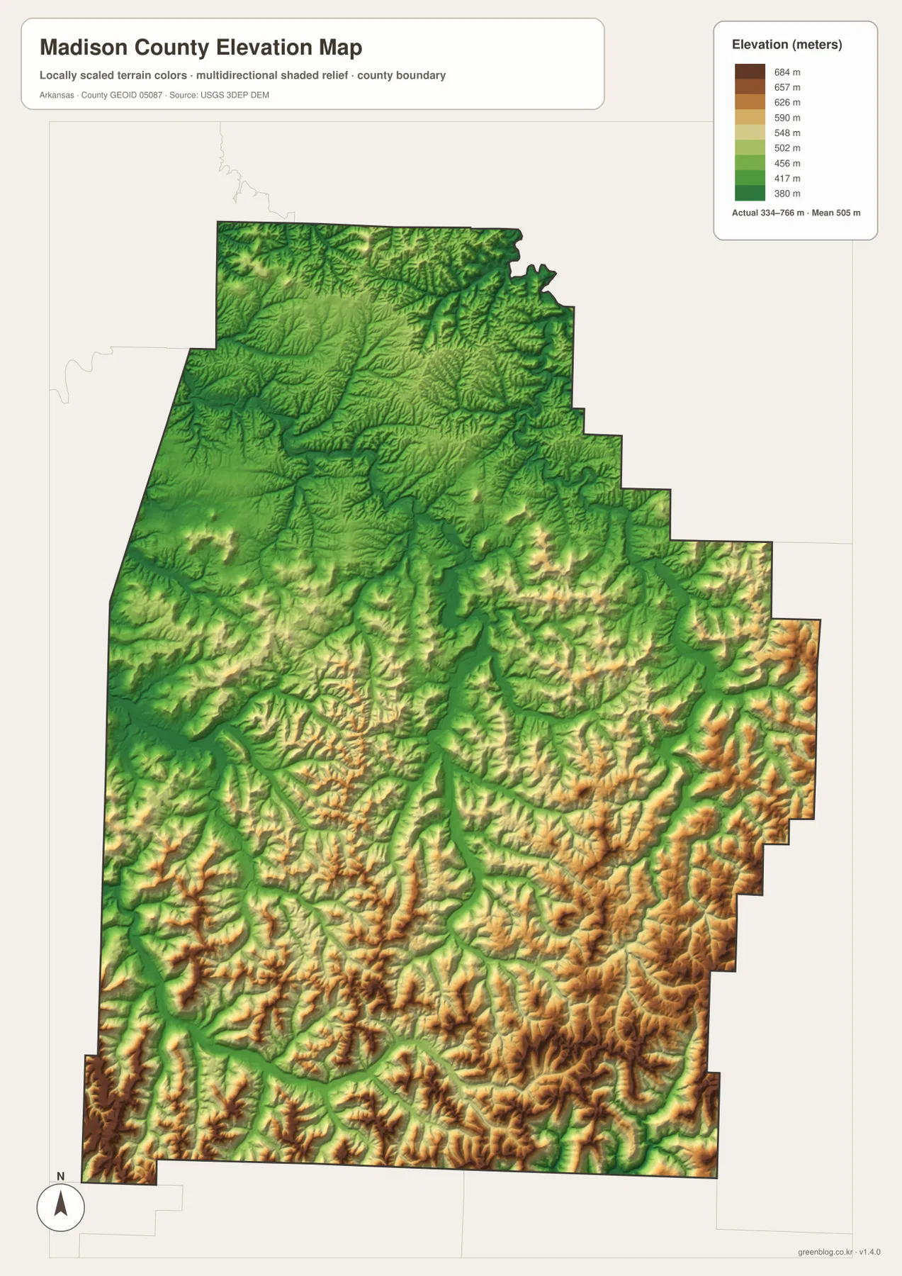
Huntsville itself is not in the highest part of the county. The town sits among broader valleys and moderate uplands, making it a natural road center. Moving east toward Kingston, the Kings River valley becomes a strong low corridor bordered by higher ridges. Moving south toward St. Paul, the relief becomes more dramatic, with green White River valleys immediately beside brown mountain ridges. The water and elevation maps together show why stream courses are so closely tied to the county’s terrain.
The Hindsville and Wesley side is also strongly rolling, but the ridge pattern is generally less continuous than the most rugged southeastern section. Roads use many of the lower valleys to reach Huntsville and neighboring counties. Rather than looking only for one high point, it is more useful to follow where ridges become tightly packed and where streams create long breaks through them. The elevation image is intended for county-scale comparison, not survey-grade measurement, so exact road, parcel, or building elevations require original elevation data or a professional survey.
Compare Kingston and St. Paul from Huntsville to see how the mountains change
A practical way to use all four maps is to begin at Huntsville and compare the eastbound route toward Kingston with the southbound route toward St. Paul. Toward Kingston, roads approach the Kings River valley and the eastern boundary, with repeated ridges on both sides. Toward St. Paul, mountain relief increases over a longer distance and the White River system becomes the most important water reference. The general, water, and elevation maps all change in the same directions, which makes the county easier to understand without memorizing every creek name.
The western Hindsville-Wesley side offers a third comparison. Hindsville is only about 8 straight-line miles from Huntsville on the city-connections map, but rolling ridges and creek valleys still separate the two places. St. Paul is about 19 straight-line miles south, and the road network becomes even more winding through the higher terrain. Madison County is therefore a good example of why direct distance, road distance, and terrain should be considered together when reading a mountain-county map.
High-resolution JPG files for Huntsville roads and Ozark river detail
The WebP images in the article are optimized for quick page viewing. The download ZIP contains the same four maps as high-resolution JPG files, each measuring 2572 × 3638 pixels in portrait orientation. Use the general map for Huntsville, Kingston, Wesley, St. Paul, and major roads; the city-connections map for direct distance from Huntsville; the terrain and water map for Kings River, War Eagle Creek, White River, and mountain tributaries; and the elevation map for comparing the county’s 334–766 meter range.
The JPG files are suitable for classroom reference, presentations, trip preparation, personal printing, and general orientation. They should not replace legal boundary records, parcel surveys, flood or whitewater safety information, engineering plans, or live navigation. When exact or current information is required, consult Census TIGER/Line boundaries, USGS hydrography, USGS elevation data, and the appropriate local or state source for the specific decision.
Frequently Asked Questions
What is the county seat of Madison County?
Huntsville is the county seat of Madison County. It is also the strongest central road reference on the supplied general map, making it useful for locating Kingston to the east, Hindsville and Wesley to the west, and St. Paul to the south.
What distances are shown from Huntsville to Hindsville and St. Paul?
The city-connections map shows about 8 miles from Huntsville to Hindsville and about 19 miles to St. Paul. These are straight-line distances rather than driving mileage, and winding mountain roads can make actual travel substantially longer.
Where is the highest terrain in Madison County?
The supplied elevation map shows the highest terrain mainly across the southern and southeastern part of the county. The actual range is about 334–766 meters with a mean near 505 meters. The Huntsville area is lower than many of the ridges around the St. Paul and southeastern mountain country.
Map File Information
The ZIP contains the general county map, city-connections map, terrain and water map, and elevation map as high-resolution JPG files for printing or offline reference.
- File Type: ZIP containing 4 JPG files
Related Maps
Sources and references
- Encyclopedia of Arkansas – Madison County – county seat, Ozark setting, Boston Mountains, and county waterways
- Encyclopedia of Arkansas – Huntsville – Huntsville and county-seat information
- U.S. Census Bureau TIGER/Line Shapefiles – county boundary and road data
- USGS National Hydrography – rivers, streams, and hydrography data
- USGS 3D Elevation Program – elevation and terrain data
Green Map creates custom-edited map images using open geographic data sources such as geoBoundaries, Natural Earth, OpenStreetMap, and government open data.
These maps are edited visual materials, not raw data files, and are provided for education, documents, presentations, and graphic reference.