Maries County in central Missouri is easiest to understand by starting with two places: Vienna near the middle of the county and Belle near the northeastern side. Route 42 passes through Vienna, U.S. 63 forms a strong north-south reference farther east, and Route 28 helps locate Belle. Between those roads, the Gasconade River, Maries River, Little Maries River, and numerous smaller creeks cut a closely spaced pattern of valleys through the hills. The maps on this page can be viewed online, and the download box farther down the article provides the high-resolution JPG originals for A3 printing and document work.
The available map views answer different questions rather than repeating the same information. The general county map is best for boundaries and highways, the city map quickly separates Belle from Vienna, the terrain-and-water view emphasizes named streams, and the elevation map shows where low river corridors sit between higher ridges. Moving between those views makes the county much easier to read than trying to interpret every road, creek, and contour cue at once.
Table of Contents
Vienna provides the simplest starting point for the county road network
On the general map, Vienna sits slightly west of the county center and works well as an orientation point. Route 42 crosses the community and continues east, while U.S. 63 runs north-south through the eastern half of the county. Belle appears in the northeast near Route 28. Route 68 is visible closer to the southeastern edge, and Route 133 provides another reference in the southwest. Once those numbered routes are familiar, the smaller local roads become much easier to place.
The county outline is not a neat rectangle. Several bends in the northern and eastern boundaries, along with an inward step along the southern side, help distinguish Maries County from its neighbors. Osage County lies to the north, Gasconade County to the east, and Miller, Pulaski, and Phelps counties border portions of the west and southwest. This context is especially useful on a printed copy, where it is easy to mark adjoining counties and compare travel directions beyond the boundary.
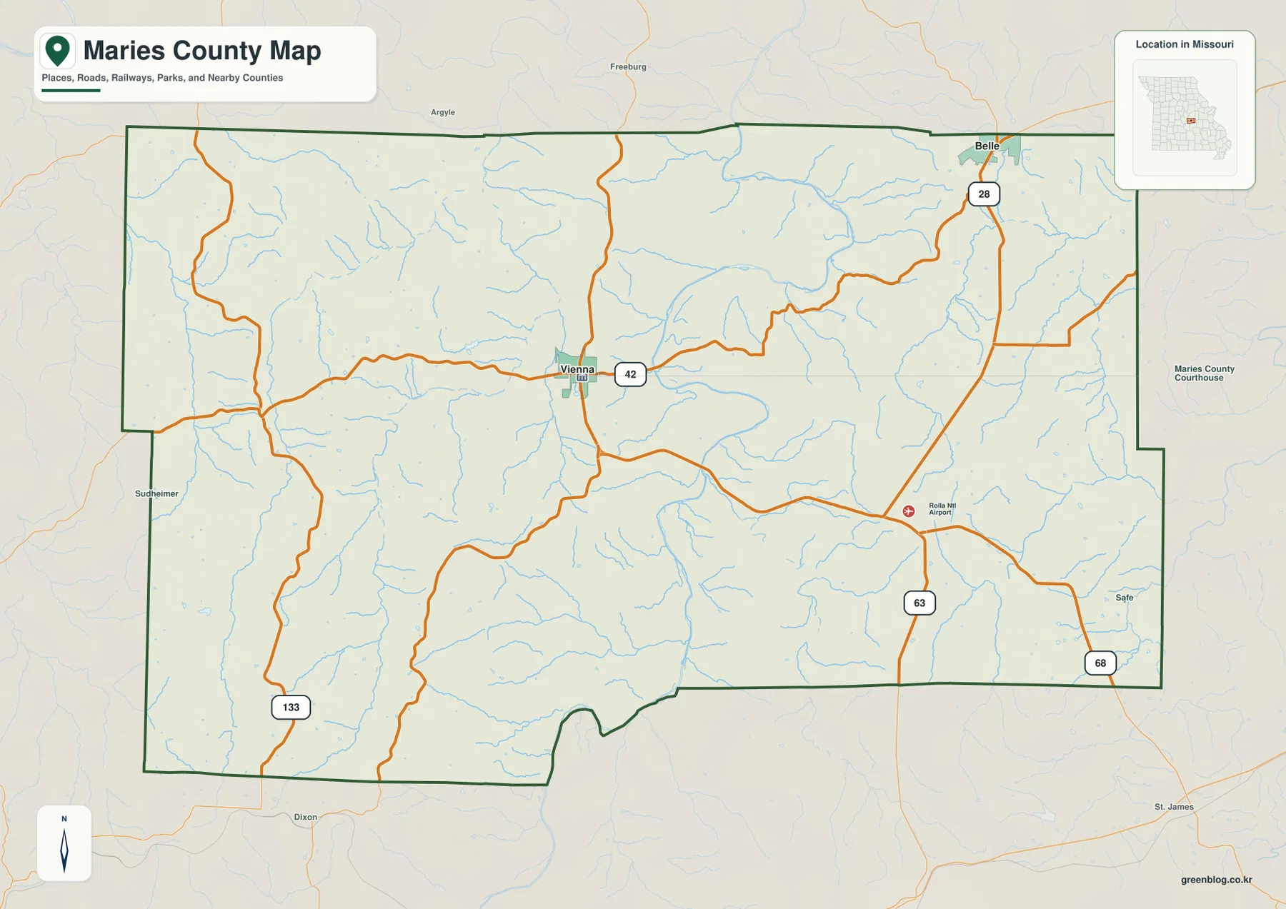
Road shape also reflects the terrain. Around Vienna, several routes come together in a relatively compact area, but many local roads become more winding toward the western and southern hills. U.S. 63 is the clearest long north-south line in the east, whereas Route 42 is more useful for reading east-west movement around Vienna. A static county map cannot show construction, closures, or travel times, so any real trip should still be checked against current Missouri transportation information or live navigation.
Belle and Vienna occupy noticeably different parts of Maries County
The city map removes much of the road and stream detail so the two highlighted communities stand out immediately. Its index lists Belle at 1,246 and Vienna at 661. Those numbers should be treated as values used in this map product rather than a replacement for the newest population estimate; current demographic figures are better checked through the Census Bureau. What matters most here is the geographic contrast: Belle is close to the northeastern boundary, while Vienna is much closer to the county interior.
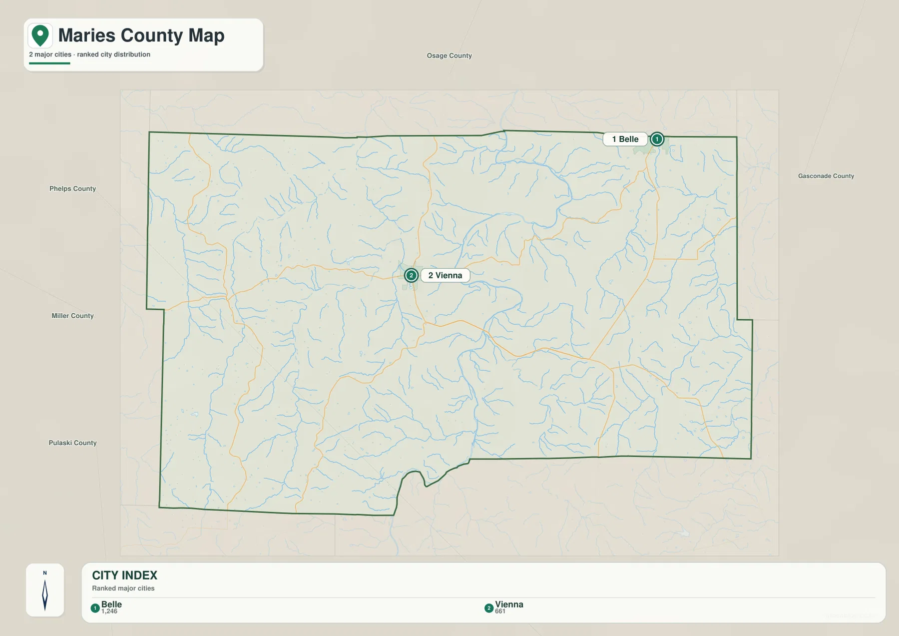
That placement gives the two communities different map relationships. Belle is visually tied to the northeastern uplands and the Route 28 area, with Gasconade County immediately beyond the county line. Vienna is more useful as a central reference because Route 42 and several local roads radiate through the surrounding area. A straight visual gap between the two towns does not translate directly into driving distance, because river crossings, ridges, and valley routes affect the actual path between them.
The county name itself is linked to local geography. According to the Missouri Secretary of State county-history material, Maries County was organized in 1855 from parts of Osage and Pulaski counties and was named for the Maries River. That connection is still easy to see on a modern map because the river remains one of the major named waterways in the western part of the county.
The Gasconade River bends through the center while the Maries system shapes the west
The terrain-and-water map gives the Gasconade River the strongest visual presence. It enters from the north-central side, makes several broad bends through the county, and continues toward the south. Numerous short tributaries join from both sides. Instead of a single straight valley, the river creates a sequence of curved lowlands that divide the surrounding hills and influence where roads can cross.
Western Maries County has a second major set of waterways. The Maries River runs generally north-south, with the Little Maries River farther west. Little Tavern Creek and Roberts Creek add smaller valleys in that part of the county. To the east, Dry Fork, Upper Pauline Creek, and Little Bourbeuse Creek appear among the named streams, while Cedar Creek, Spring Creek, and Mill Creek provide additional local references. Together they show why the county surface is broken into many narrow ridges rather than one broad plateau.
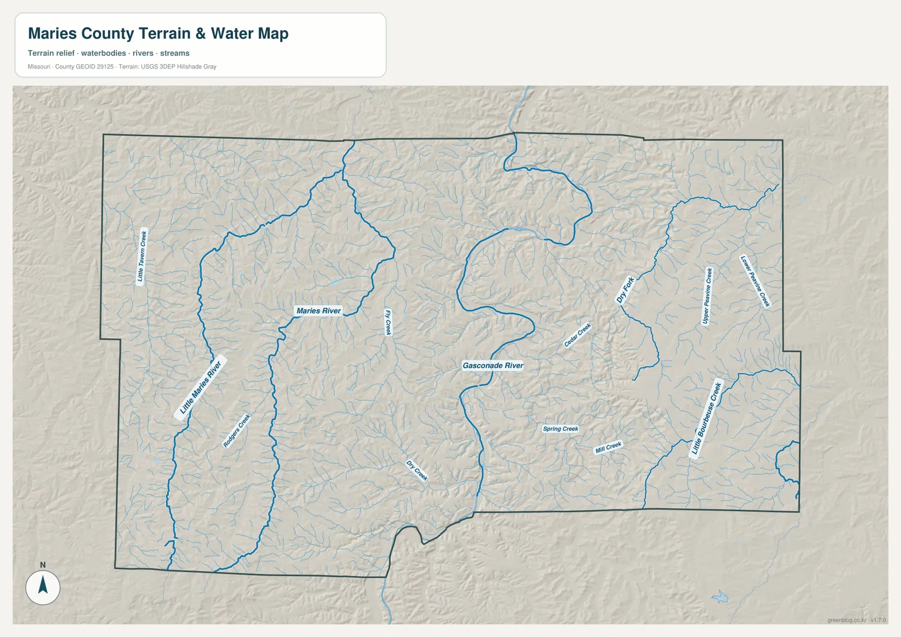
Vienna is not directly on the main Gasconade channel, but it sits among smaller tributary valleys in the central part of the county. Belle lies in the northeast, where higher ground and shorter drainage valleys are more prominent. The water map is useful for locating these features, but it does not show river stage, water quality, safe public access, or flood conditions. Fishing, paddling, flood planning, and property access all require current information from the appropriate agency or landowner.
Relief from 174 to 371 meters explains many of the road and river curves
The elevation map reports a range of about 174 to 371 meters, with a mean elevation of 272 meters. Lower ground is shown in green, while yellow, tan, and brown mark progressively higher terrain. Maries County does not form one simple slope. Instead, low stream corridors weave between higher ridges, creating a repeated ridge-and-valley landscape across much of the county.
The Gasconade River is especially easy to follow because its broad bends coincide with a continuous low corridor. Higher ground rises close to both sides of the valley. The Maries and Little Maries rivers show a similar relationship in the west, though their valleys are narrower and separated by long ridges. In the southwest and northeast, larger patches of high ground remain between the smaller creeks, and those creeks cut side valleys that make the relief look more intricate at county scale.
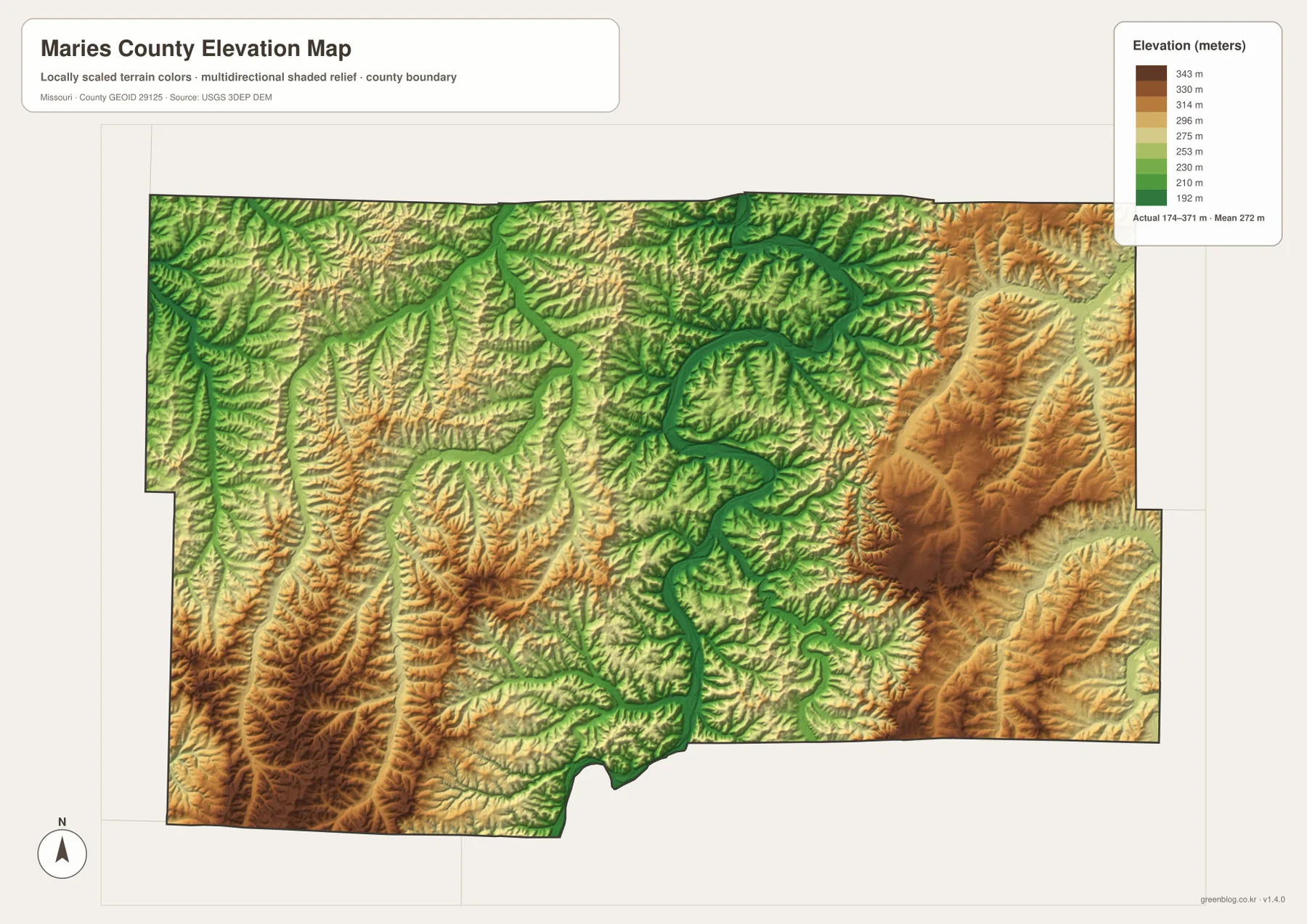
Eastern Maries County is also more varied than the city map alone suggests. Lower strips along Dry Fork and Upper Pauline Creek interrupt the uplands, while the larger Gasconade valley sits farther west and south. Comparing this surface with the road map helps explain why local routes often bend instead of following straight section-like lines. The elevation graphic is meant for regional comparison, not for surveying, construction design, or parcel-level slope calculations; detailed work should begin with source data such as the USGS 3D Elevation Program.
Choose the map by the question you are trying to answer
For a first look at the county, a practical sequence is to find Vienna, trace Route 42, locate U.S. 63, and then move northeast to Belle. After those landmarks are familiar, the Gasconade and Maries rivers become easier to place. The elevation map can then be used as the final layer of context, showing why river valleys, ridges, and road bends repeatedly occur in the same parts of the county.
For classroom or research use, there is no need to force every feature into one graphic. Use the general map when county boundaries and numbered roads matter, the city map when settlement location is the main question, the water map for named rivers and creeks, and the elevation map for relief. Keeping those purposes separate produces cleaner presentations and makes small labels easier to read on paper.
Cross-reading is most useful at specific locations. Vienna can be identified by its road connections on the general map, by its central position relative to Belle on the city map, and by the surrounding tributary valleys on the terrain-and-water view. Belle produces a different combination: northeastern position, Route 28 access, and nearby uplands. Those contrasts make the county feel less abstract and show how communities relate to the land around them.
Use the original JPG files when print detail matters
The WebP images in the article are reduced for efficient page viewing. The downloadable archive contains the four original JPG maps—general county, city, water, and elevation—at 3638×2572 pixels each. The larger files are better suited to A3 layouts, classroom handouts, presentations, and documents where highway numbers or small creek labels need to remain legible after resizing.
These maps are appropriate for orientation, classroom reference, trip preparation, and general publication work, but they are not legal or operational records. Parcel ownership, survey boundaries, regulated flood zones, emergency routing, and current highway restrictions require the relevant official dataset. A printable county map is a useful starting point; decisions with legal, safety, or engineering consequences should be checked against current authoritative sources.
Frequently Asked Questions
Which map is best for following the Gasconade River through Maries County?
Start with the water map because it shows the full river channel and named tributaries most clearly. Then compare the same bends on the elevation map, where the river follows a lower green corridor between higher ridges. Add the general county map when you also want to see how Route 42, U.S. 63, and local roads approach the river valleys.
How do Vienna and Belle differ in location?
Vienna is closer to the middle of the county and is a useful reference for Route 42 and central local roads. Belle sits near the northeastern boundary around the Route 28 area. The city map shows that contrast most simply, while the general and elevation maps add the road and terrain context around each community.
What files are included in the download?
The ZIP contains four high-resolution JPG images: the general county map, city map, water map, and elevation map. Each original is 3638×2572 pixels, giving more room for labels and print layout than the smaller WebP previews displayed in the article.
Map File Information
Download the high-resolution A3-ready JPG originals for Maries County in one ZIP archive.
- Included Files: Use only the versions confirmed in the article and supplied images
- File Type: Use the confirmed download contents
- Intended Use: Printing, education, presentations, and map-based projects
Related Maps
Sources and references
The following official and public resources provide additional county history, current statistics, boundary data, hydrography, and elevation information.
- Missouri Secretary of State – Origins of Missouri Counties
- Missouri Association of Counties – Maries County
- U.S. Census Bureau QuickFacts – Maries County, Missouri
- U.S. Census Bureau TIGER/Line Shapefiles
- USGS National Hydrography
- USGS 3D Elevation Program
Green Map creates custom-edited map images using open geographic data sources such as geoBoundaries, Natural Earth, OpenStreetMap, and government open data. These maps are edited visual materials, not raw data files, and are provided for education, documents, presentations, and graphic reference.