Polk County spans a broad part of northwestern Minnesota where two landscapes meet. The western side lies low beside the Red River of the North, with East Grand Forks near the state line and Crookston farther inland along the Red Lake River. Farther east and southeast, the ground rises and the map becomes more crowded with small lakes, tributaries, and smaller communities. That west-to-east contrast is the most useful idea to keep in mind when reading the maps on this page.
Four downloadable maps are included: a county overview, a ranked city distribution map, a terrain-and-water map, and an elevation map. The overview is best for locating cities and highways, while the water map separates named rivers and lakes more clearly. The elevation layer then explains why the western Red River side looks so different from the higher eastern part of the county. High-resolution JPG versions of all four maps are available in the download box below.
Table of Contents
From the Red River boundary to Crookston
The western edge of Polk County follows the Red River, a distinctive natural boundary that separates Minnesota from North Dakota in this part of the valley. East Grand Forks sits directly beside that river and appears near U.S. 2 and Minnesota Highway 220 on the county map. The city is part of a cross-river urban area with Grand Forks, North Dakota, but this map keeps the emphasis on the Minnesota side and the shape of Polk County rather than on detailed street navigation.
Crookston is the county seat and sits southeast of East Grand Forks, close to the Red Lake River. Polk County’s official overview describes the county as roughly 2,013 square miles, with 58 townships and 15 cities. That large area helps explain why the county cannot be understood from one urban center alone. Western communities relate strongly to the Red River corridor, while settlements such as Fosston, McIntosh, Fertile, and Erskine are spread across the southern and eastern parts of the county.
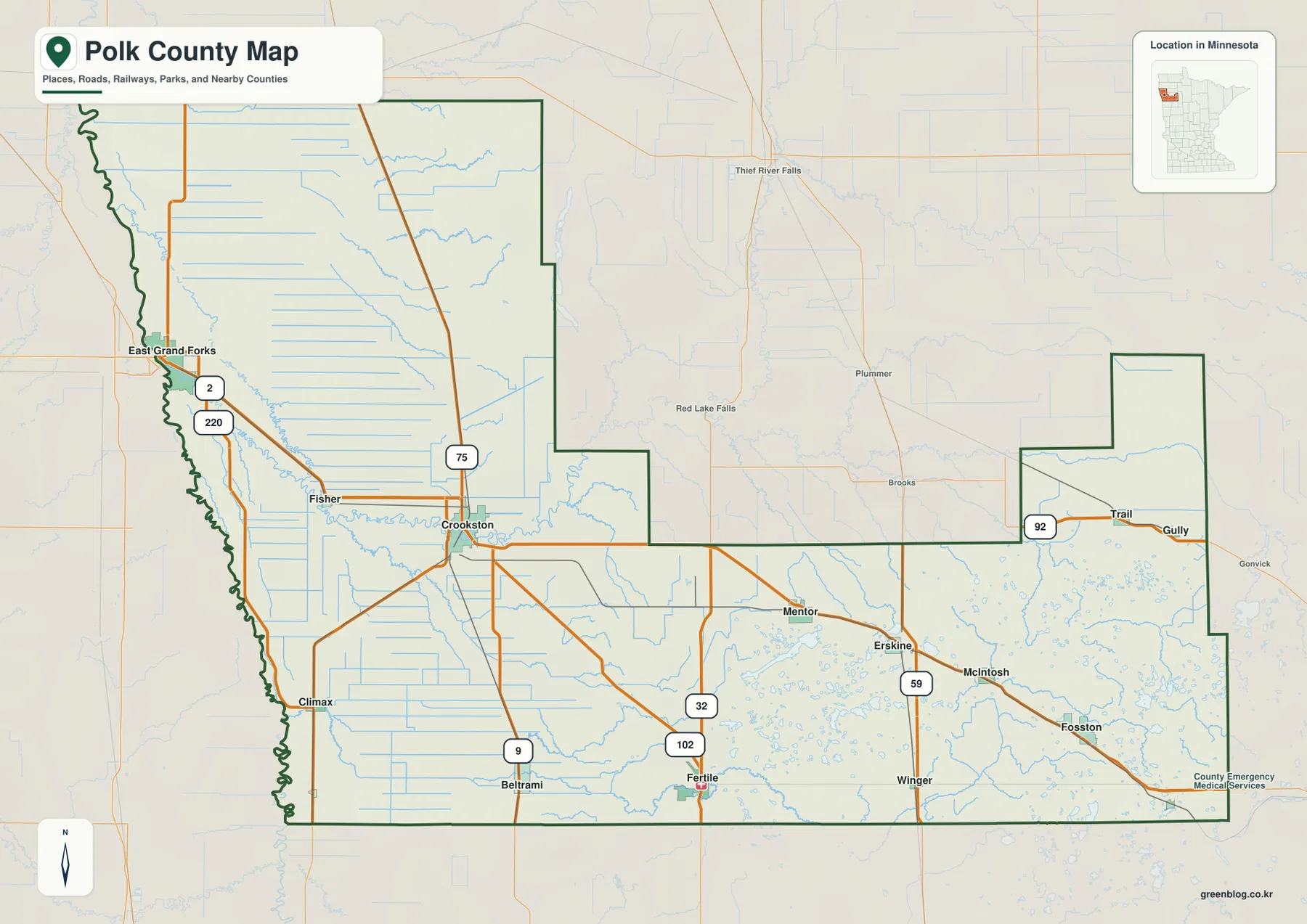
U.S. 75 runs through the Crookston area, while U.S. 2 links the East Grand Forks side with Crookston and points farther east. The map also labels Minnesota Highways 9, 32, 59, 92, and 102 in different parts of the county. These routes help reveal the county’s settlement pattern: the largest mapped cities are in the west, and smaller places form a looser chain across the south and east. The overview is deliberately simplified, so it should not be treated as a complete road atlas or as a source for every local road, parcel line, or municipal boundary.
A ranked city view instead of a distance diagram
The city map is a ranked distribution view, not a connector or distance map. Its city index lists six selected communities and places them on the county outline without drawing straight-line distance measurements between them. East Grand Forks is shown with an index value of 9,028 and Crookston with 7,344. The remaining mapped cities are Fosston at 1,374, McIntosh at 847, Fertile at 803, and Erskine at 427. Those numbers belong to the map’s city index and should not be read as mileage.
The spatial pattern is more important than the ranking alone. East Grand Forks anchors the Red River edge, Crookston occupies a central-western position near the Red Lake River, and Fosston sits much farther east. McIntosh, Fertile, and Erskine fill in the southeastern and southern parts of the county. Because the map highlights only six major cities, it does not imply that these are the county’s only communities. Its value is in showing how the more prominent settlements are distributed across a very large county.
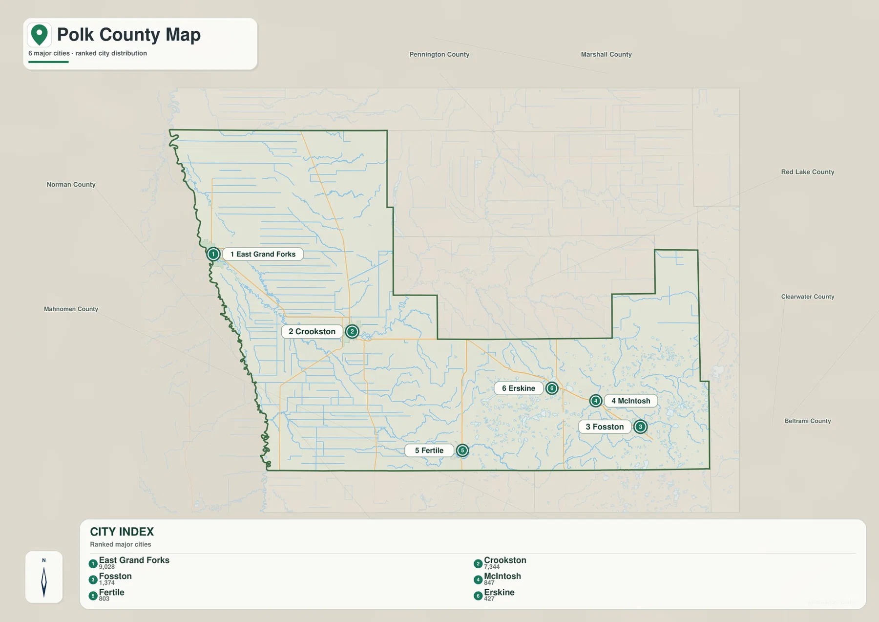
This city view works especially well beside the county overview. On the overview, roads and rivers explain how Crookston and East Grand Forks connect to the surrounding landscape. On the ranked map, the reduced detail makes the west-heavy settlement pattern easier to see. The eastern cities are more widely spaced, and the background water network becomes denser toward the lake-rich side of the county. For classroom or reference use, pairing the two maps gives more context than trying to force every kind of information into one image.
Red Lake River, Sand Hill River, and the lake-rich east
The Red Lake River is the dominant interior waterway on the supplied terrain-and-water map. It crosses the county toward the west, passes through the Crookston area, and continues toward the Red River. Polk County’s own river-buffer information notes that rainfall within the county ultimately reaches the Red River system and then flows north toward Lake Winnipeg. That drainage relationship gives the county a strong westward hydrologic orientation even though many tributaries begin or spread across the eastern half.
The southern part of the map shows the Sand Hill River, while the east includes named streams such as the Hill River, Poplar River, and Lost River. Several lakes also appear in the eastern and southeastern landscape, including Maple Lake, Oak Lake, Cross Lake, Turtle Lake, Sand Hill Lake, Kittleson Lake, and Union Lake. In contrast, the low western plain contains long, straighter drainage features and fewer prominent lake basins. That difference is one of the clearest visual signatures of Polk County.
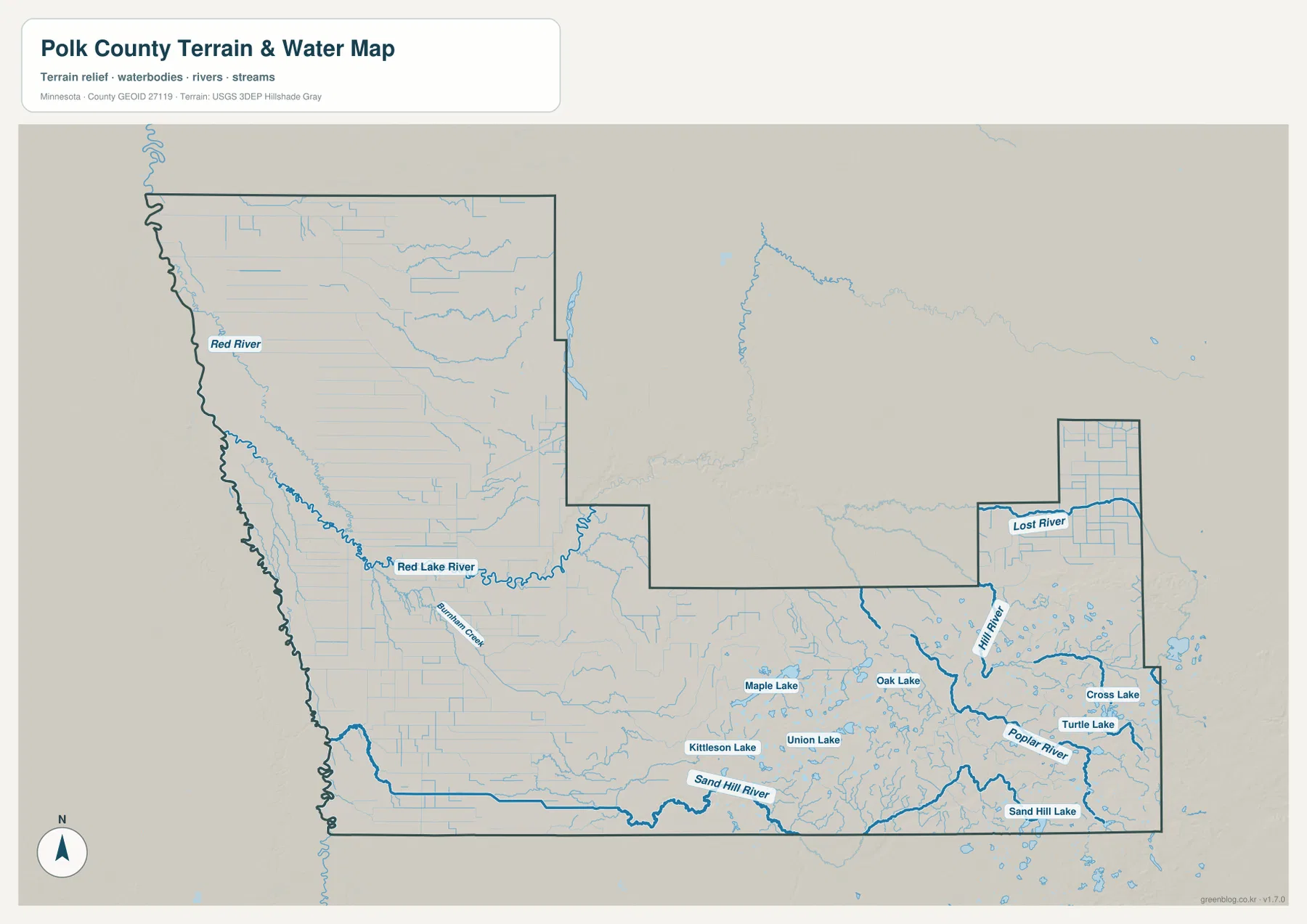
This is a geographic water reference map, not a flood map or navigation chart. A blue line confirms the mapped location of a stream or river, but it does not show flood probability, channel depth, legal access, or safe boating conditions. Its best use is comparison: trace the Red Lake River toward the Red River, look at the Sand Hill River across the south, and then compare the denser eastern lake-and-stream network with the much flatter western side.
Why the west is low and the southeast rises
The elevation map makes the county’s broad landform contrast immediately visible. The generalized surface ranges from about 240 to 477 meters across the mapped area, with a mean near 309 meters. Dark green dominates the Red River side, indicating the lowest ground. Moving east and especially southeast, the colors shift through lighter greens and yellows into tan and brown, marking substantially higher terrain. The transition is gradual across much of the county rather than a single sharp escarpment.
Northwestern Minnesota’s Red River Valley is closely tied to the history of Glacial Lake Agassiz. Minnesota Historical Society material explains how that immense glacial lake and its later drainage helped create the broad, shallow Red River valley. Polk County’s western half fits that setting well: it is low, gently sloping, and crossed by numerous drainage channels. The eastern side is more varied, with higher ground, small basins, and a more intricate network of lakes and streams.
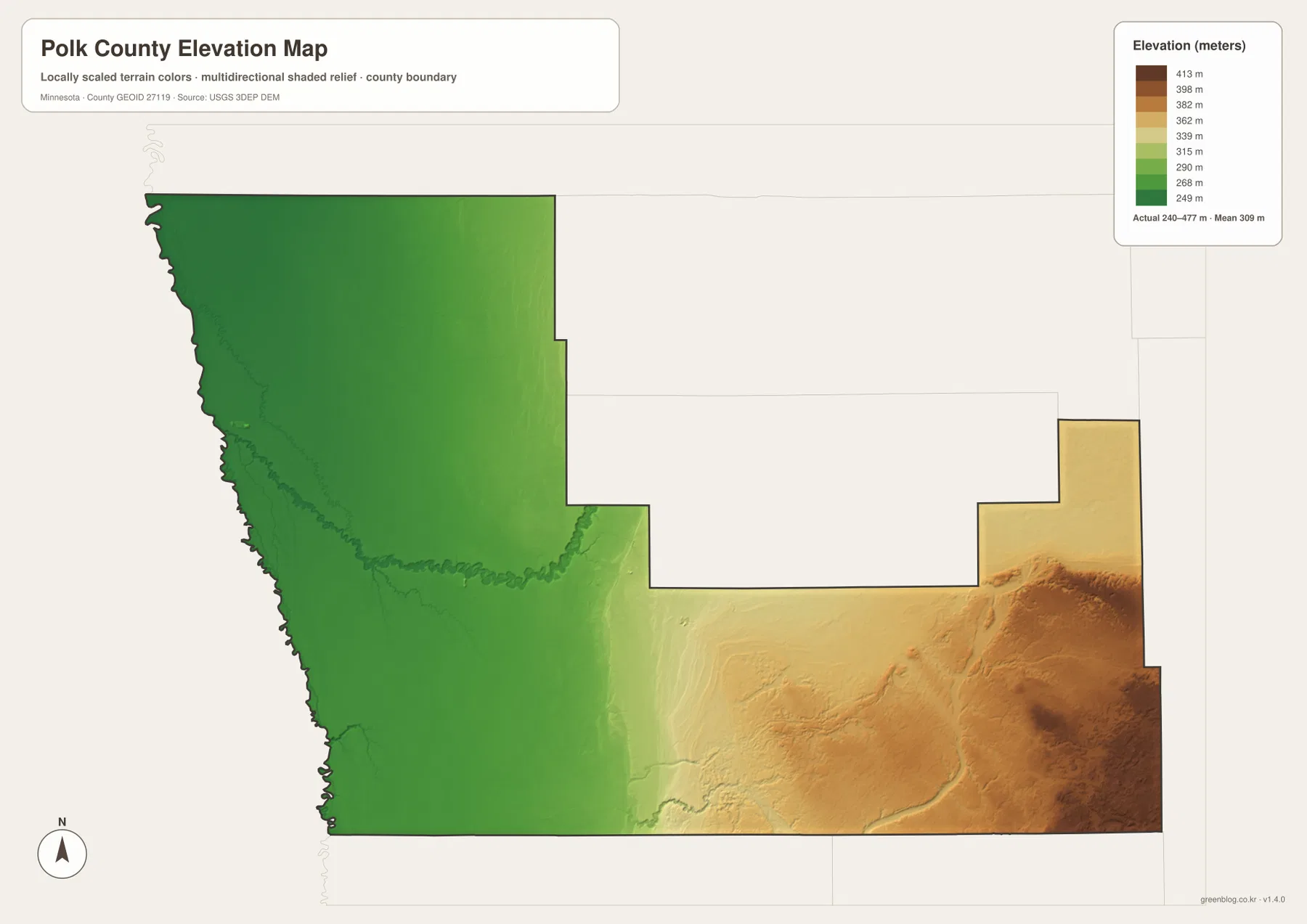
The elevation colors are useful for regional comparison, but they are not survey-grade measurements. They should not be used to determine the exact height of a building site, road grade, or engineering project. For general map reading, however, the layer adds important context. It shows why the river-bordering west has such a broad, flat appearance and why the eastern water map contains more varied terrain around its lakes and tributaries.
Which Polk County map is most useful for your task?
For a first look at Polk County, use the county overview. It balances place names, major roads, the county outline, and selected waterways without hiding the overall shape. If your question is about where the main population centers sit, the ranked city map removes most of the road detail and makes the settlement pattern easier to compare. For named rivers and lakes, the terrain-and-water layer is the clearer choice because it gives the hydrographic network more visual emphasis.
The elevation map is most useful when the question involves landform rather than place names. It can help explain the transition from the low Red River Valley to higher ground toward the eastern and southeastern edge. Using it beside the water map is particularly effective because the two layers show how relief and drainage relate. If you only need a printable county location reference, however, the general county map is usually the simplest and most legible option.
The downloadable JPGs preserve more detail than the smaller on-page previews. Each source image is 3638 by 2572 pixels, and the ZIP keeps all four map types together. These maps are intended for geographic reference and presentation. For legal boundaries, property ownership, flood determinations, engineering elevations, or current turn-by-turn travel, use the appropriate official agency or specialized map service rather than relying on this simplified county set.
Frequently Asked Questions
Is Crookston or East Grand Forks the Polk County seat?
Crookston is the county seat. East Grand Forks is highly prominent on the western boundary because it sits beside the Red River and connects closely with Grand Forks, North Dakota, but county government is centered in Crookston. The two cities therefore represent different kinds of geographic importance within the county.
Do the numbers on the city map show distance between cities?
No. This city view uses a ranked distribution format. The values shown beside East Grand Forks, Crookston, Fosston, McIntosh, Fertile, and Erskine belong to the city index; the map does not draw or label straight-line or driving distances between those places.
What is the clearest terrain pattern in Polk County?
The strongest pattern is the low, flat Red River side in the west and the rise toward higher, more varied terrain in the east and southeast. The water map reinforces that contrast by showing a simpler western drainage setting and a greater concentration of named lakes and tributaries farther east.
Map File Information
The ZIP contains the four original high-resolution JPG maps described on this page. These files are larger than the on-page previews and are suitable when you need a clearer copy for print, classroom material, or a presentation.
- Included Files: Use only the versions confirmed in the article and supplied images
- File Type: Use the confirmed download contents
- Intended Use: Printing, education, presentations, and map-based projects
Related Maps
Sources and reference links
The county-specific observations above are based on the supplied maps and the following official or authoritative references. These links are useful when you need more detailed boundary, hydrography, elevation, or county information.
- Polk County official overview — county seat, area, city and township counts, and local features
- Polk County Ditch & River Buffers — official explanation of county drainage and the Red River watershed
- U.S. Census Bureau TIGER/Line — county and transportation boundary data
- USGS National Hydrography — national river, stream, and waterbody data
- USGS 3D Elevation Program — national elevation data and 3DEP documentation
Green Map creates custom-edited map images using open geographic data sources such as geoBoundaries, Natural Earth, OpenStreetMap, and government open data. These maps are edited visual materials, not raw data files, and are provided for education, documents, presentations, and graphic reference.