Otter Tail County stretches across a lake-filled part of west-central Minnesota, with Fergus Falls as the largest city in the southwest and Perham and New York Mills forming important references in the northeast. Between them lies a dense landscape of lakes, smaller towns, and branching rivers. This guide connects the road network with Otter Tail Lake, Star Lake, Lake Lida, the Pelican and Otter Tail rivers, and the county’s large elevation differences. The four map themes shown on the page are also available as high-resolution JPG originals in one downloadable ZIP.
Two reference points make the county easier to understand: Fergus Falls for roads and settlement, and Otter Tail Lake for the central water landscape. Fergus Falls anchors the southwest, while Battle Lake and Ottertail lead into the lake district farther east. Perham and New York Mills sit in the northeast, and Pelican Rapids provides a strong reference in the northwest. Once those places are located, the county’s seemingly complicated pattern of roads, lakes, and ridges becomes much easier to follow.
Table of Contents
A Wide Road Network from Fergus Falls to Perham
The county overview shows Fergus Falls as the broadest urban footprint and the main road center in the southwest. Minnesota 210 heads east toward Battle Lake, while Minnesota 59 and other numbered routes create connections south and southeast. Pelican Rapids sits well to the northwest near Minnesota 108, separated from Fergus Falls by a wide rural and lake-filled area. That spacing makes the western half feel less like one continuous corridor and more like several town centers linked across open countryside.
Perham is the strongest northeastern road reference. Minnesota 228 reaches the city from the north, and east–west roads continue toward New York Mills and the county boundary. Ottertail lies near an important central junction, with Henning and Vining farther south. Battle Lake sits between the Fergus Falls side and the central lake country, making it useful for orienting trips that cross the county from southwest to northeast.
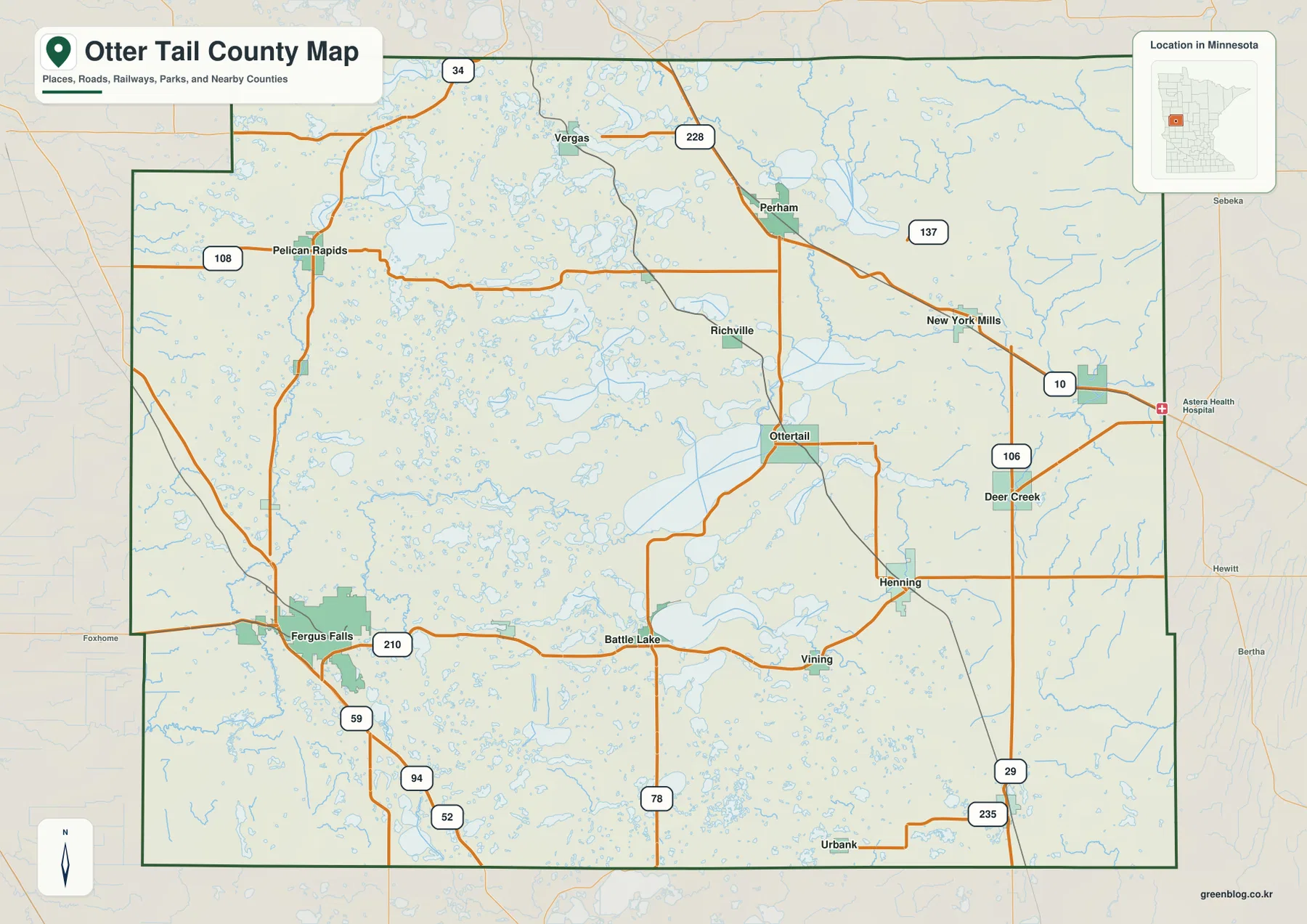
The county boundary has an irregular stepped section in the northwest and long straighter segments along the south and east. Smaller places such as Vergas, Richville, Deer Creek, and Urbank appear on the overview, showing how widely settlement is distributed beyond the six ranked cities. The map is intended for county-scale orientation and road context, not parcel ownership, zoning, or legal survey work.
Six Major Cities Spread across the Southwest, Northeast, and Lake Country
The ranked city distribution map highlights six communities. Its index lists Fergus Falls at 14,181, Perham at 3,627, Pelican Rapids at 2,586, New York Mills at 1,371, Parkers Prairie at 980, and Henning at 860. Fergus Falls is clearly the largest, but the remaining cities occupy very different parts of the county. Perham and New York Mills are in the northeast, Pelican Rapids is northwest, Parkers Prairie is southeast, and Henning sits east of the center.
Fergus Falls and Perham form two distant anchors rather than neighboring urban centers. Between them are extensive lake areas and smaller places such as Battle Lake and Ottertail. Pelican Rapids helps define the western side, while New York Mills provides an eastern reference farther north. Parkers Prairie and Henning show how the settlement pattern extends into the southeastern half instead of ending around the central lakes.
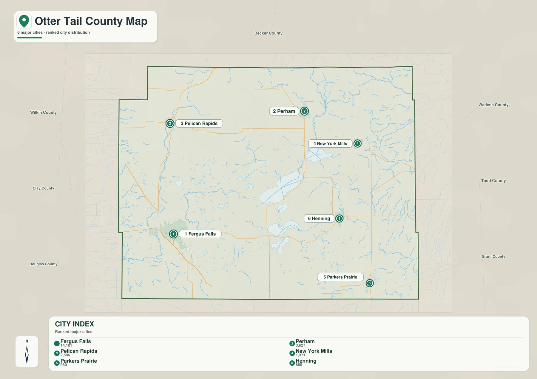
The surrounding labels place Becker County to the north, Wadena and Todd counties to the east, Douglas and Grant counties to the south, and Wilkin and Clay counties to the west. That context makes the internal city pattern easier to interpret: Fergus Falls lies closer to the southwestern edge, while Perham is well inside the northeastern half. The index values are the figures supplied with the map; current official population estimates should be checked against the latest Census data when needed.
Otter Tail Lake inside a Dense Network of Lakes and Rivers
Water is the defining geographic feature of much of Otter Tail County. The central and northern portions are crowded with lakes of many sizes, including Lake Lida, Star Lake, Big Pine Lake, Rush Lake, West Battle Lake, and Otter Tail Lake. Otter Tail County itself maintains a dedicated Lakes of Otter Tail County resource for its extensive lake system, reinforcing what is immediately visible on the map: water is not a minor background feature here but a major part of the landscape.
Otter Tail Lake forms a useful center for understanding the connected water network. Dead River approaches from the Star Lake area to the north, Rush Lake lies to the northeast, and Pelican Bay extends from the eastern side of the large lake. Numerous smaller lakes and short channels fill the spaces between these named features. The result is a landscape where a single lake label rarely tells the whole story because nearby basins and connecting waterways are part of the same local setting.
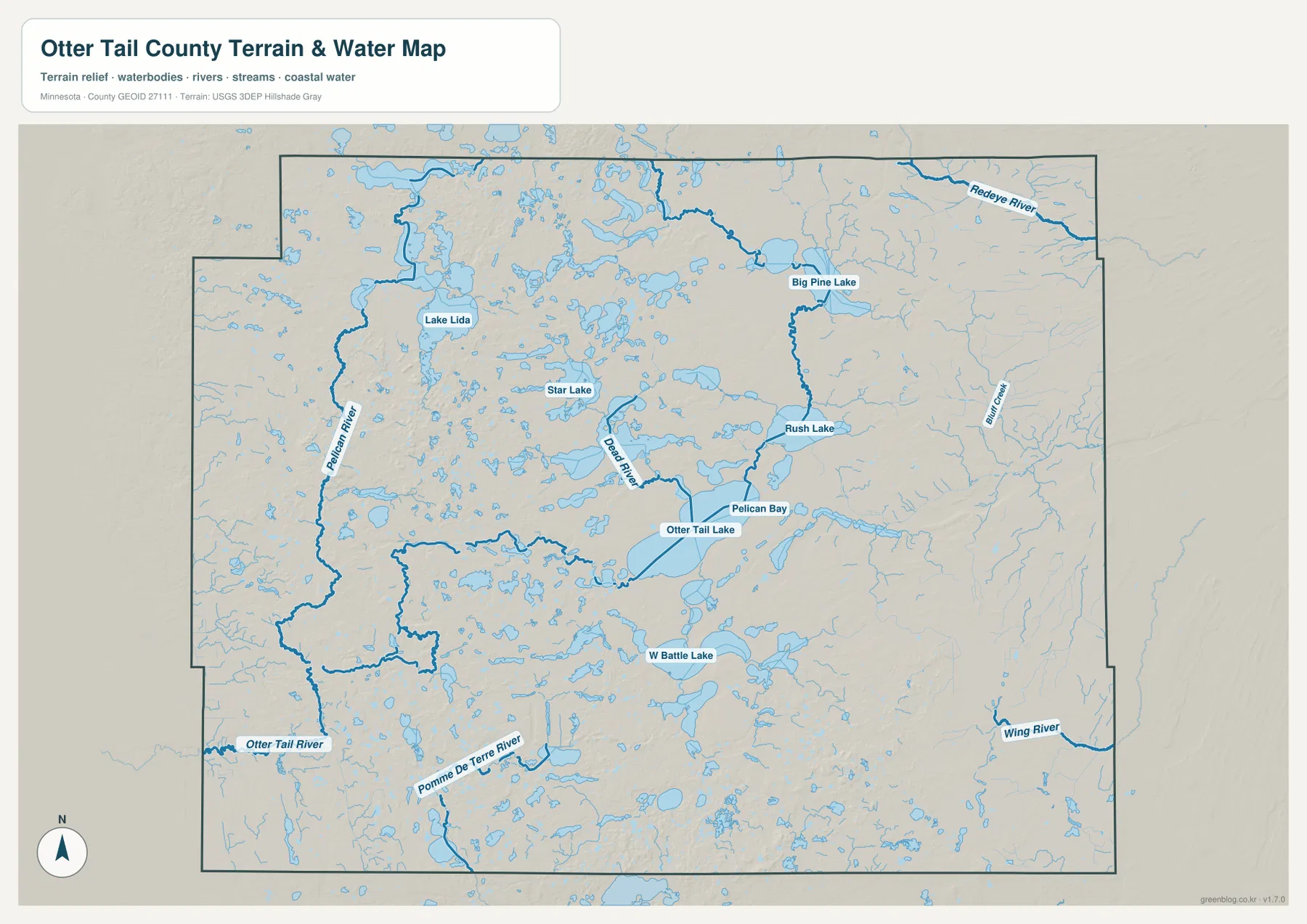
The county’s rivers spread across several drainage directions. Pelican River runs through the western side, Otter Tail River appears in the southwest, and Pomme de Terre River crosses the south. Wing River and Bluff Creek are on the east, while Redeye River is visible near the northeastern edge. This distribution shows that the county is not organized around one river basin alone; multiple river systems pass through a landscape already filled with lakes.
Minnesota DNR describes the Otter Tail River as beginning at Elbow Lake in Becker County, passing through many lakes as it flows west, and eventually joining the Bois de Sioux River before becoming part of the Red River of the North system. The map here is for geographic reference rather than flood, depth, navigation, shoreline ownership, or public-access decisions. Current DNR and local information should be used for boating, paddling, and safety planning.
Low Southwestern Ground Rising into Higher Eastern Uplands
The elevation map shows a strong contrast across the county. Its legend gives an actual range of about 308 to 542 meters with a mean near 413 meters. The west and southwest contain broad green lowlands, while yellows, oranges, and browns become more common toward the east and northeast. The eastern edge is substantially higher than the Fergus Falls side, even though numerous lower lake basins interrupt the uplands.
The central lake district has especially complex relief. Rounded hills, narrow low areas, and lake basins repeat over short distances around Star Lake, Otter Tail Lake, and neighboring waters. Higher knobs also appear in the northwest, so the western half is not uniformly low. Still, the broad pattern rises from the southwest toward the east, with many local exceptions created by the lake-rich terrain.
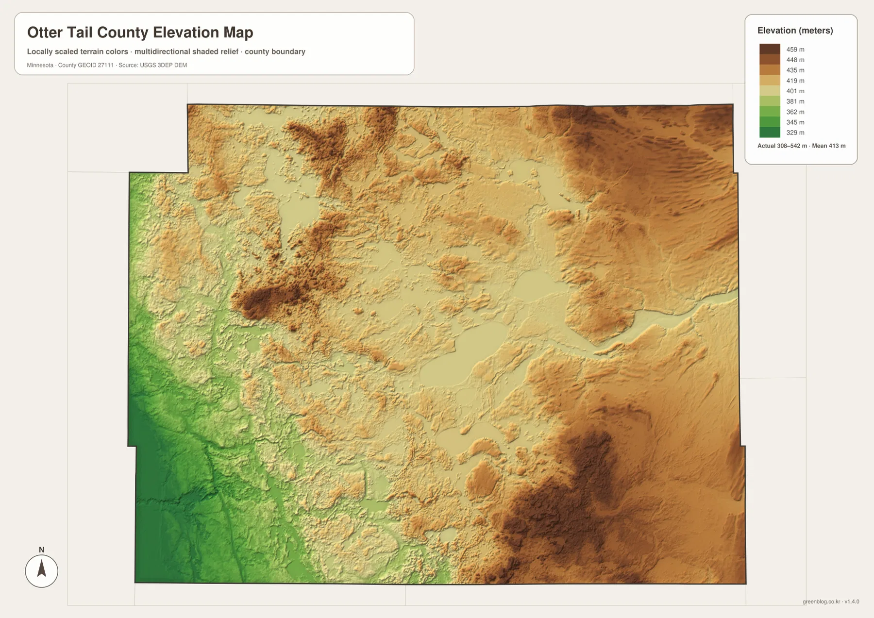
The southeast contains large areas of brown high ground around the Parkers Prairie and Henning side, while Fergus Falls and the western edge remain much greener. The water map helps explain the relief because many lakes and streams occupy lower pockets between ridges. In the center, this creates a patchwork of water, low corridors, and elevated ground rather than a simple continuous slope.
The colors are scaled specifically to show differences inside Otter Tail County. A brown or green shade on another county map may represent a different absolute elevation. The shaded surface is intended for broad geographic interpretation, not survey-grade measurement, so engineering, construction, drainage design, and legal elevation work require more precise source data or field measurements.
Choosing the Best View for Roads, Lakes, Rivers, and Relief
For roads and settlement orientation, begin with the county overview. It is the best map for following Minnesota 210 from Fergus Falls toward Battle Lake, locating Ottertail and Henning in the center-east, and then moving north toward Perham and New York Mills. The ranked city map is more efficient when the main question is how the six highlighted communities are distributed across such a large county.
For natural geography, start at Otter Tail Lake and compare the surrounding Star Lake, Lake Lida, Big Pine Lake, and Rush Lake area before tracing the Pelican, Otter Tail, Pomme de Terre, and Wing rivers. The elevation map then adds the larger setting by showing lower western terrain and higher eastern uplands, with many lake basins cutting into that general rise.
The WebP previews on the page are optimized for quick viewing. The downloadable ZIP contains the corresponding high-resolution JPG originals for the county overview, city distribution, water, and elevation maps. Each file is 3638 by 2572 pixels, making the originals more useful for printing or zooming into small road numbers, lake names, and stream labels than a browser screenshot.
A practical way to understand Otter Tail County is to start in Fergus Falls, move east through Battle Lake and the Otter Tail Lake area, and then continue toward Perham and New York Mills. After that, compare Pelican Rapids in the northwest and Parkers Prairie in the southeast. Finishing with the water and elevation maps reveals the county’s central geographic theme: dense lake country spread across rolling terrain that rises markedly toward the east.
Frequently Asked Questions
Which map is best for locating Fergus Falls and Otter Tail Lake?
Start with the county overview. Fergus Falls is in the southwest, while Otter Tail Lake is farther east in the central lake district, with Battle Lake and Ottertail helping connect the two areas. Use the water map next if you want to see Dead River, Rush Lake, Pelican Bay, and the surrounding lake network in more detail.
Where is the densest lake area in Otter Tail County?
The water map shows the strongest concentration across the central and northern portions of the county. Lake Lida, Star Lake, Big Pine Lake, Rush Lake, Otter Tail Lake, and many smaller waters sit close together. The county also maintains a dedicated lakes resource because the local lake system is so extensive.
Which part of Otter Tail County is highest?
The broad pattern rises toward the east and northeast, while the west and southwest are generally lower. The elevation legend shows an actual range of about 308–542 meters and a mean near 413 meters. Local hills also occur in the northwest and central lake district, so the surface is more complicated than a single smooth west-to-east slope.
Map File Information
The ZIP contains the original high-resolution JPG versions of the Otter Tail County overview, city distribution, water, and elevation maps.
- File Type: ZIP containing 4 JPG files
Related Maps
Sources and References
- Otter Tail County official website – county government and local information
- Lakes of Otter Tail County – county-specific lake-system information
- Minnesota DNR Otter Tail River State Water Trail – river course and water-trail information
- U.S. Census Bureau TIGER/Line Shapefiles – county boundary and geographic reference data
- USGS 3D Elevation Program – elevation reference data
Green Map creates custom-edited map images using open geographic data sources such as geoBoundaries, Natural Earth, OpenStreetMap, and government open data. These maps are edited visual materials, not raw data files, and are provided for education, documents, presentations, and graphic reference.