Pennington County in northwestern Minnesota is centered on Thief River Falls, but the maps show a much broader rural landscape extending east toward Goodridge and south toward St. Hilaire. The Red Lake River crosses the county from east to west, while the Thief River approaches from the north and joins it near Thief River Falls. This guide connects the settlement pattern with U.S. 59, the river network, drainage channels, and the county’s clear west-to-east elevation change. The four map themes shown on the page are also available as high-resolution JPG originals in one downloadable ZIP.
Thief River Falls is the easiest place to begin because roads, settlement, and two major rivers all meet in the same area. U.S. 59 continues south toward St. Hilaire, while Minnesota 1 and Minnesota 32 help connect the city with surrounding parts of the county. Goodridge lies much farther east in a sparsely settled agricultural area. Once those three communities are located, the water and elevation maps reveal why the western side feels flatter and lower than the eastern half.
Table of Contents
Thief River Falls as the County’s Road and Settlement Center
The county overview makes Thief River Falls the dominant road and settlement center. U.S. 59 passes through the city and continues south toward St. Hilaire, while Minnesota 1 crosses the Thief River Falls area and provides an important east–west reference. Minnesota 32 is another major route on the southern side of the city. A regular grid of county roads spreads outward from the urban area, making the transition from the city to surrounding farmland easy to see.
Goodridge is located well east of Thief River Falls and acts as the main northeastern community on the map. Minnesota 219 and surrounding numbered roads provide references in that part of the county, but the road network is more dispersed than around Thief River Falls. St. Hilaire, by contrast, is much closer to the U.S. 59 corridor south of the county’s main city. The three settlements therefore occupy distinctly different positions rather than forming one continuous urban chain.
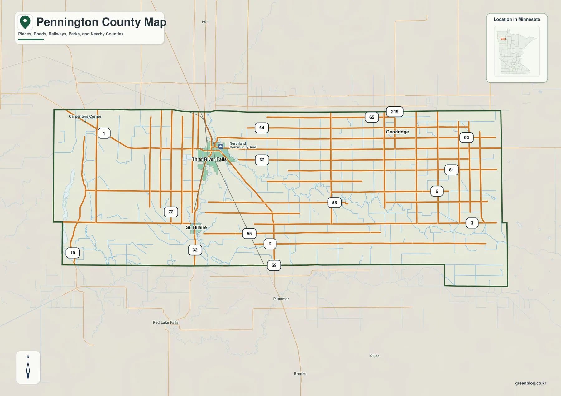
Pennington County borders Marshall County to the north, Beltrami County to the east, Clearwater and Red Lake counties to the south and southeast, and Polk County to the west. The southeastern boundary includes a stepped extension rather than one straight rectangular edge. This map is intended for county-scale orientation and road context, not parcel ownership, zoning, or legal survey decisions.
Three Major Communities Spread from St. Hilaire to Goodridge
The ranked city distribution map highlights three major communities. Its index lists Thief River Falls at 8,823, St. Hilaire at 259, and Goodridge at 49. Thief River Falls is overwhelmingly the largest place shown, while the other two communities are much smaller and widely separated. The figures are best treated as the index supplied with this map; current official population estimates should be checked against the latest U.S. Census Bureau data when needed.
The location pattern is simple but useful. Thief River Falls sits in the west-central part of the county, St. Hilaire is south of it, and Goodridge lies far to the northeast. St. Hilaire is closely associated with the same north–south travel corridor as Thief River Falls, while Goodridge occupies a different rural road network. The simplified city map makes that separation much easier to judge than the more detailed county overview.
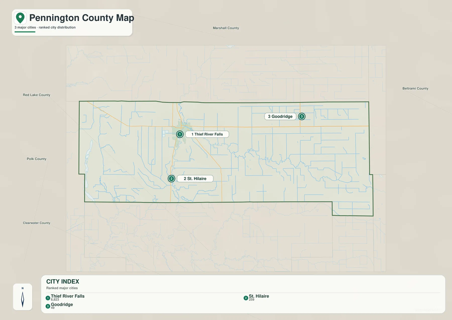
The map also labels surrounding counties, including Marshall to the north, Beltrami to the east, Clearwater to the southeast, Red Lake to the south, and Polk to the west. That context shows Thief River Falls relatively close to the western side and Goodridge representing the broader eastern half. For smaller settlements, local roads, and exact road connections, the county overview remains the more useful companion map.
The Red Lake and Thief Rivers Meeting near Thief River Falls
The Red Lake River and Thief River are the defining waterways on the map. Red Lake River enters from the east, bends repeatedly across the county, and continues west through the Thief River Falls area. Thief River approaches from the north and meets the Red Lake River near the city. Minnesota DNR’s Red Lake River State Water Trail uses Thief River Falls as an important segment reference, which matches the river junction visible on the supplied map.
Across the central and eastern county, Red Lake River receives numerous small channels and managed drainage lines. County Ditch Number 21 and other numbered ditches are visible near the river, reflecting the importance of drainage in a broad agricultural landscape. The water layer therefore shows more than natural streams: it also reveals a network of constructed channels that help move water across relatively flat land.
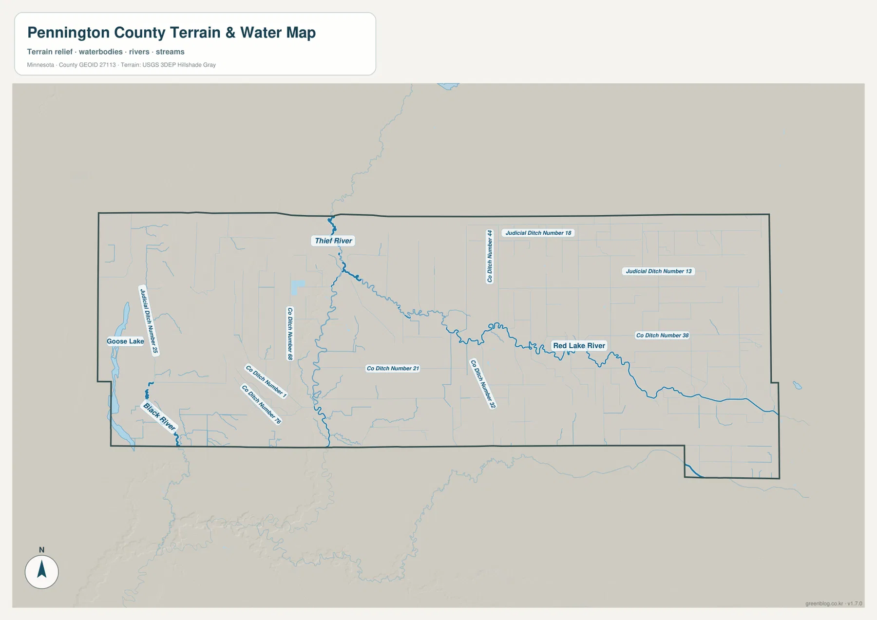
The southwest contains Black River, while Goose Lake appears near the western edge. Judicial Ditch Number 18, Judicial Ditch Number 13, County Ditch Number 38, and several other drainage features cross the northern and eastern portions. Pennington County is not a lake-dominated landscape; its water pattern is better understood as a combination of two major rivers, small tributaries, a few local lakes, and an extensive drainage network.
This map is for geographic reference rather than floodplain, navigation, depth, drainage-rights, shoreline-ownership, or public-access decisions. River conditions on the Red Lake River can change, and Minnesota DNR recommends checking current conditions before a paddling trip. Local or official resources should also be used when drainage rights or property boundaries matter.
Low Western Plain Rising toward Higher Eastern Farmland
The elevation map shows a pronounced rise from west to east. Its legend gives an actual elevation range of about 296 to 362 meters with a mean near 342 meters. Deep greens dominate the western edge, indicating the lowest terrain, while lighter greens and yellows appear through the central transition. Most of the eastern half is orange and brown, showing land that stands noticeably higher than the western plain.
Thief River Falls lies close to the transition between the lower west and the higher east. The Thief River and Red Lake River occupy narrow lower corridors that cut through the broader surface, and the land continues to fall toward the western side of the county. Goodridge and much of the eastern agricultural area sit on a higher, comparatively broad surface. The total relief is modest compared with mountainous counties, but the county-scale contrast is still very clear.
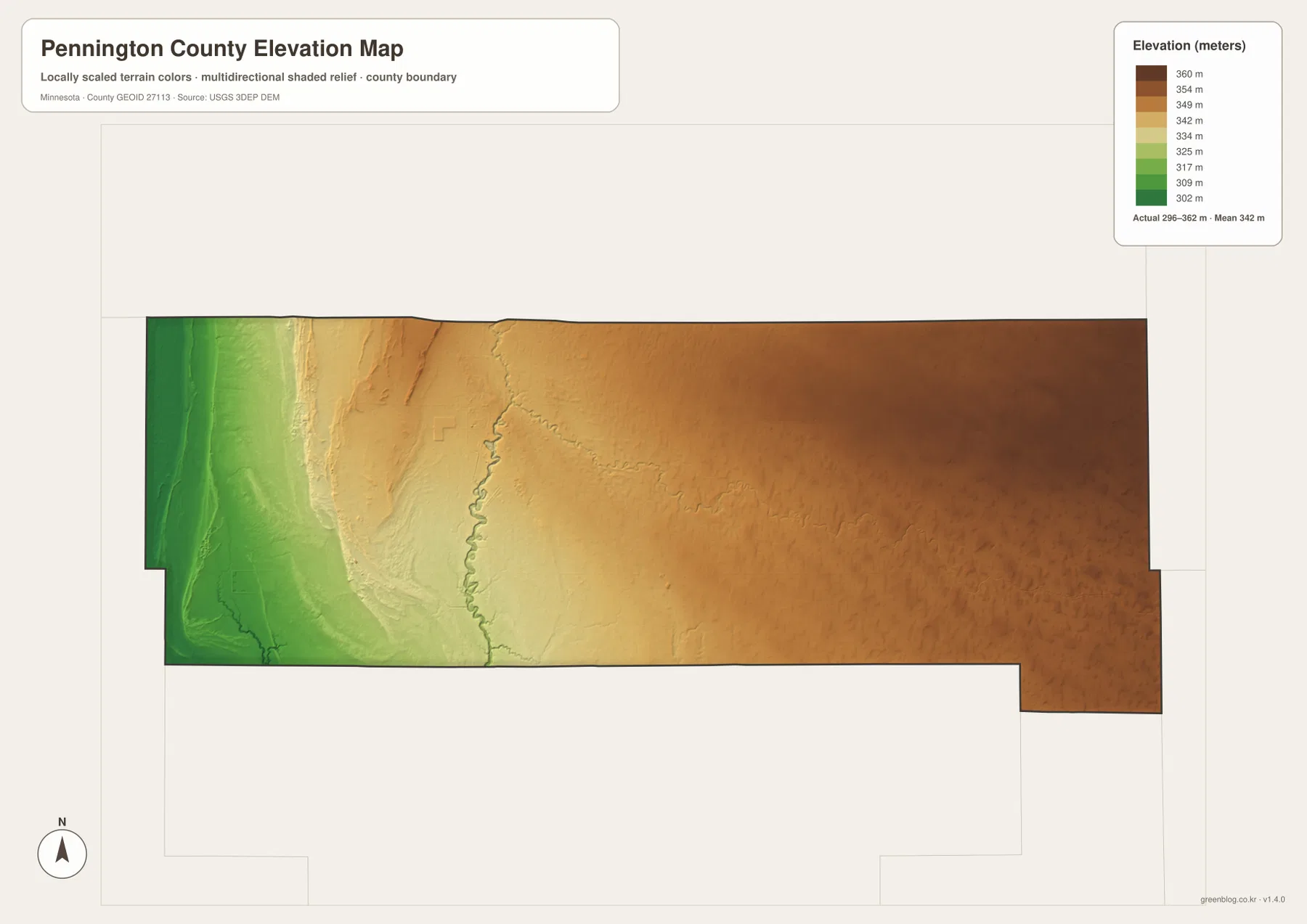
The water and elevation maps reinforce each other. Red Lake River crosses from the higher east toward the lower western plain, while Thief River descends from the north to meet it near Thief River Falls. Goose Lake and Black River occupy lower western terrain, which is reflected in the green colors of the elevation view. This pairing makes the direction of the county’s broad topographic change easier to understand than either map alone.
The colors are scaled specifically to show variation inside Pennington County. A brown or green shade on another county map may represent a different absolute elevation. The shaded surface is intended for broad geographic interpretation, not survey-grade measurement, so engineering, construction, drainage design, and legal elevation work require more precise source data or field measurements.
Choosing the Best View for Roads, Rivers, and Relief
For roads and settlement orientation, begin with the county overview. It shows how U.S. 59, Minnesota 1, and Minnesota 32 relate to Thief River Falls and how St. Hilaire and Goodridge sit in different parts of the county. The ranked city map is more efficient when the main question is simply the relative position and scale of the three highlighted communities.
For natural geography, trace the Red Lake River from east to west and then locate the Thief River coming down from the north. Black River, Goose Lake, and the named drainage ditches add detail to the broader water network. The elevation view explains the overall setting by showing low western terrain and a steady rise toward the east, with river valleys remaining lower than the surrounding surface.
The WebP previews on the page are optimized for quick viewing. The downloadable ZIP contains the corresponding high-resolution JPG originals for the county overview, city distribution, water, and elevation maps. Each file is 3638 by 2572 pixels, making the originals better for printing or zooming into small road, river, and drainage labels than a browser screenshot.
A practical way to understand Pennington County is to start at Thief River Falls, move south to St. Hilaire, and then compare the long eastward distance to Goodridge. After that, use the water map to follow the Red Lake and Thief rivers and finish with the elevation map. The sequence reveals a simple county-wide pattern: one dominant city near the river junction, smaller settlements spread across farmland, and terrain that rises from west to east.
Frequently Asked Questions
Which map is best for locating Thief River Falls and St. Hilaire?
Start with the county overview. Thief River Falls is the largest urban area in the west-central part of the county, and St. Hilaire is south of it near U.S. 59. The ranked city map is useful as a second view when you want to compare both places with Goodridge.
Where do the Red Lake River and Thief River meet?
The water map shows the Thief River descending from the north and joining the Red Lake River near Thief River Falls. Red Lake River then continues west. Anyone planning river recreation should check current Minnesota DNR water-trail and river-condition information rather than relying on the static map alone.
Which side of Pennington County is highest?
The eastern side is higher than the western side. The elevation legend shows an actual range of about 296–362 meters and a mean near 342 meters. Thief River Falls sits near the transition, while the Goodridge side is mostly orange and brown and the western edge is predominantly green.
Map File Information
The ZIP contains the original high-resolution JPG versions of the Pennington County overview, city distribution, water, and elevation maps.
- File Type: ZIP containing 4 JPG files
Related Maps
Sources and References
- Pennington County official website – county government and GIS information
- Minnesota DNR Red Lake River State Water Trail – river route and Thief River Falls segment information
- Minnesota Department of Transportation – Hwy 59 South of Thief River Falls – U.S. 59 road reference
- U.S. Census Bureau TIGER/Line Shapefiles – county boundary and geographic reference data
- USGS 3D Elevation Program – elevation reference data
Green Map creates custom-edited map images using open geographic data sources such as geoBoundaries, Natural Earth, OpenStreetMap, and government open data. These maps are edited visual materials, not raw data files, and are provided for education, documents, presentations, and graphic reference.