Cedar County in western Missouri can be followed from El Dorado Springs on U.S. 54 southeast toward Stockton and then into the deeply indented shoreline of Stockton Lake. El Dorado Springs sits close to the northwestern county line, while Stockton lies farther inside the county near Route 39 and Route 215. The supplied maps also show the Sac River, numerous creeks, and a countywide elevation range of about 221 to 336 meters. High-resolution JPG originals are available together in the ZIP download box below.
The county does not revolve around a single continuous town corridor. El Dorado Springs is separated from Stockton, Jerico Springs lies toward the southwest, and Umber View Heights appears south of Stockton near the lake country. That spacing matters because the road network is only one part of the story. Long lake arms and creek valleys break up the land between communities and help explain why direct distance and actual driving distance can differ.
Stockton is also the county seat, with the Cedar County Courthouse identified by the official county website. On the maps, its central-southern location makes it a convenient place from which to understand the transition from the road network to the lake and river landscape. El Dorado Springs, by contrast, is more closely tied to the western and northern county edges. Looking at both towns first provides an easy framework for the rest of the county.
Table of Contents
U.S. 54 at El Dorado Springs and the roads converging on Stockton
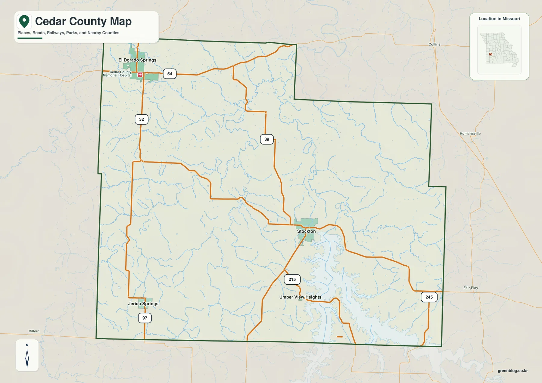
The general county map places El Dorado Springs just inside the northwestern boundary. U.S. 54 runs east-west through the community, Route 32 heads south, and Cedar County Memorial Hospital is labeled nearby. This combination of a major U.S. highway, a state route, and a recognizable local facility makes El Dorado Springs the easiest starting point for orienting the northwestern part of the county.
Farther southeast, Route 39 comes down through the county toward Stockton. Route 215 extends southwest from the Stockton area, while Route 245 reaches toward the eastern county line. The roads do not form one simple grid around the town; they bend and separate as they approach the lake country. Stockton therefore serves as a useful transition between the relatively simple road view and the much more irregular shoreline and valley system to the south and east.
Jerico Springs appears in the southwest along Route 97, away from the El Dorado Springs–Stockton line. Umber View Heights is smaller and lies south of Stockton. These locations show why Cedar County is better understood as a group of separated rural communities than as one continuous developed strip. Reaching them may require a combination of north-south and diagonal roads rather than a single direct highway.
Names outside the county, including Collins, Humansville, and Fair Play, provide useful regional context. They help a reader see which side of Cedar County faces communities in neighboring parts of western Missouri. The map is intended for geographic orientation rather than live navigation, so road closures, construction, lane arrangements, speed limits, and current travel times should be checked with up-to-date transportation sources.
Straight-line distances from El Dorado Springs to the main communities
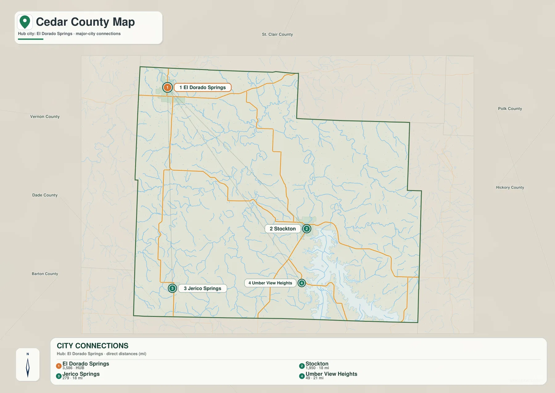
The city-connections map strips away most secondary road detail and uses El Dorado Springs as the hub. El Dorado Springs is numbered 1, Stockton 2, Jerico Springs 3, and Umber View Heights 4. The design is useful when the main question is where those communities sit relative to one another, not which sequence of roads a driver should follow.
The distance panel identifies its measurements as direct distances. Stockton is shown at about 18 miles from El Dorado Springs, Jerico Springs at about 18 miles, and Umber View Heights at about 21 miles. These are straight-line measurements between places, not driving mileage. A road trip can be longer because roads curve around creeks, intersect at different angles, and sometimes have to work around the long inlets of Stockton Lake.
The map also highlights the county’s uneven settlement pattern. El Dorado Springs is close to the western and northern sides, Stockton is deeper in the county toward the center-south, Jerico Springs sits in the southwest, and Umber View Heights lies south of Stockton. The four communities are spread across different directions rather than clustered around one metropolitan center.
Neighboring county labels help reinforce that contrast. St. Clair County appears to the north, Vernon County to the west, Dade and Barton Counties toward the southwest and west, and Polk and Hickory Counties to the east. A classroom slide or presentation can use this simplified map to introduce community spacing quickly, while the general map remains the better choice for discussing U.S. 54, Route 39, or an actual road path.
Stockton Lake, the Sac River, and creek valleys across Cedar County
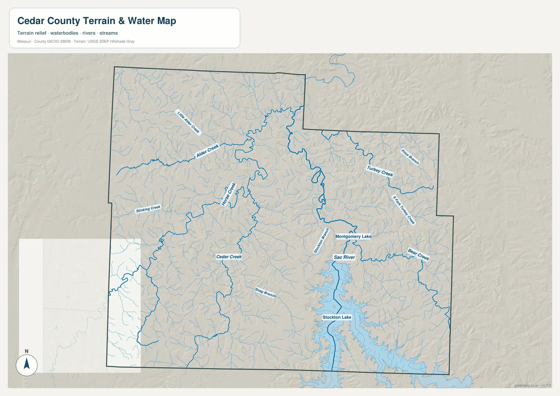
Water becomes the dominant feature on the terrain-and-water map. Stockton Lake fills a large part of the south-central and southeastern county, but its shape is far from simple. Long arms extend into narrow valleys, producing a deeply indented shoreline. Stockton sits just northwest of the broad lake system, so the town marks a natural shift from the road-focused view of the county to the lake and river landscape.
The Sac River is the principal named river associated with the lake system. Alder Creek and Little Alder Creek appear toward the northwest, Cedar Creek crosses part of the western interior, and Turkey Creek and Bear Creek are shown farther east. Smaller channels fill many of the spaces between those named streams. The result is a landscape divided by repeated creek valleys rather than broad uninterrupted blocks of high ground.
Montgomery Lake is labeled near the upper part of the Stockton Lake area, and Snag Branch is among the smaller named waterways visible elsewhere in the county. The value of the map is not in memorizing every creek name. Instead, it shows why a place that looks close on a straight line may be separated by a cove, a creek valley, or a winding road route. The physical geography helps explain the practical differences seen in the city-distance map.
This water reference should not be treated as an official floodplain, boating, legal-boundary, or property map. It shows the relative location of rivers, creeks, lake arms, and surrounding terrain. Current reservoir levels, flood risk, shoreline rules, boating conditions, and regulatory boundaries require current information from USGS, FEMA, Missouri agencies, or the appropriate local authority.
Relief from about 221 to 336 meters around the lake and river valleys
The elevation map gives Cedar County a mapped range of roughly 221 to 336 meters, with a mean near 277 meters. Lower green colors follow the Sac River and the valleys leading into Stockton Lake, while yellow, tan, and brown colors mark higher ground around them. The low areas form connected corridors instead of one broad flat plain, which matches the branching shape of the creeks and lake inlets.
Higher ground is widespread in the west and southwest, but it is broken by narrow creek valleys. Similar ridges appear on the eastern side of the county, where Turkey Creek, Bear Creek, and smaller channels cut through the uplands on their way toward the main lake and river system. This repeated alternation of ridges and valleys is one reason the county’s surface looks much more complex than the road map initially suggests.
The north is not flat either. Streams descending from the El Dorado Springs side and from the northeastern boundary create narrow lower strips between modest uplands. A road map with relatively few major highways can give an impression of simple open country, but the elevation map reveals many small rises and hollows beneath that sparse road network.
The approximately 115-meter difference between the mapped low and high points is appropriate for countywide comparison, not engineering measurement. Color bands are intended to make broad elevation differences easy to see. They should not be used to determine a precise parcel elevation, building-pad height, road grade, or drainage design. Site-specific work requires original elevation data, survey information, or field measurements.
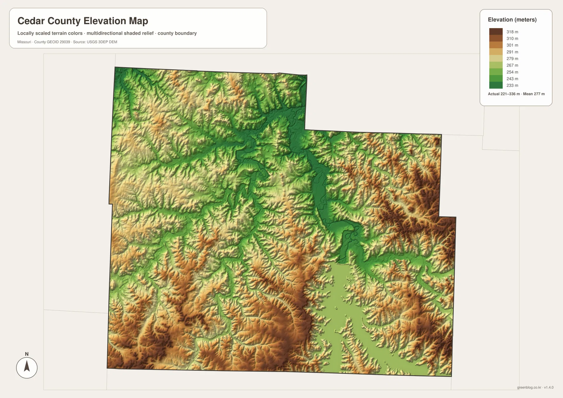
Green lower terrain is not the same thing as an official flood zone. Elevation is only one factor in flood behavior, which also depends on rainfall, river level, reservoir operation, soils, channel capacity, and regulatory studies. The elevation map works well for comparing high and low land, but FEMA mapping and current hydrologic information are required for actual flood-risk decisions.
Which Cedar County map to use for roads, communities, water, or terrain
Choose the general county map when road numbers and place names need to be seen together. It shows how El Dorado Springs, Stockton, Jerico Springs, and Umber View Heights relate to U.S. 54, Route 32, Route 39, Route 215, Route 245, and Route 97. Nearby place labels outside the county also make it useful for explaining Cedar County’s position within western Missouri.
The city-connections map is better when the main question is how the principal communities are spaced around El Dorado Springs. Its straight-line labels allow quick comparison without the visual weight of a complete road network. Because those numbers are direct distances, however, they should not be converted directly into driving time or assumed to match route mileage.
For Stockton Lake, the Sac River, and tributary valleys, use the terrain-and-water map. It makes the lake’s branching arms and the county’s dense network of creek valleys much easier to see. The elevation map then adds a simple comparison between those lower valleys and the surrounding ridges. Used together, the two maps explain much of the irregular terrain around central and southern Cedar County.
The downloadable archive contains four high-resolution JPG originals matching the maps in this article. Each file measures 3638 × 2572 pixels, providing more room to inspect route numbers, small place labels, creek names, shoreline detail, and elevation colors than the web previews. The files work well for general reference, classroom materials, presentations, and print layouts, but they are not legal surveys, engineering drawings, live navigation products, or official flood maps.
Frequently Asked Questions
Where are El Dorado Springs and Stockton within Cedar County?
El Dorado Springs is close to the northwestern county line on U.S. 54 and Route 32. Stockton lies farther southeast in the county interior near Route 39 and Route 215, with the upper reaches of Stockton Lake beginning just to its south and east.
Are the 18-mile and 21-mile labels on the city map driving distances?
No. The map identifies those values as direct distances. Stockton and Jerico Springs are each shown about 18 miles from El Dorado Springs, while Umber View Heights is about 21 miles away. Actual driving mileage can be longer because roads follow available crossings and the irregular terrain around Stockton Lake.
Does the green terrain near Stockton Lake show an official flood zone?
No. Green represents relatively lower elevation on this county-scale map. Official flood risk must be checked with FEMA flood mapping, current USGS hydrologic information, and guidance from local or state authorities.
Map File Information
The ZIP contains the high-resolution JPG originals for the county map, city-connections map, terrain-and-water map, and elevation map shown in this article.
- Included Files: 4 maps
- File Type: JPG
Related Maps
Sources and reference links
- Cedar County, Missouri official website: county information and the Cedar County Courthouse in Stockton.
- U.S. Census Bureau TIGER/Line Shapefiles: official geographic data for county boundaries, roads, and related features.
- USGS National Hydrography: reference information for rivers, creeks, lakes, and other water features.
- USGS 3D Elevation Program: elevation and terrain data.
Green Map creates custom-edited map images using open geographic data sources such as geoBoundaries, Natural Earth, OpenStreetMap, and government open data. These maps are edited visual materials, not raw data files, and are provided for education, documents, presentations, and graphic reference.