Bates County lies along western Missouri, with Butler near the middle of the county road network, Adrian to the north, Rich Hill to the south, and smaller communities spread toward the Kansas line and the lower Osage basin. This Bates County map set separates roads and places, ranked city locations, waterways, and elevation so each layer is easy to read. The high-resolution JPG versions of all four maps are available in the download box below for printing, classroom use, and detailed reference.
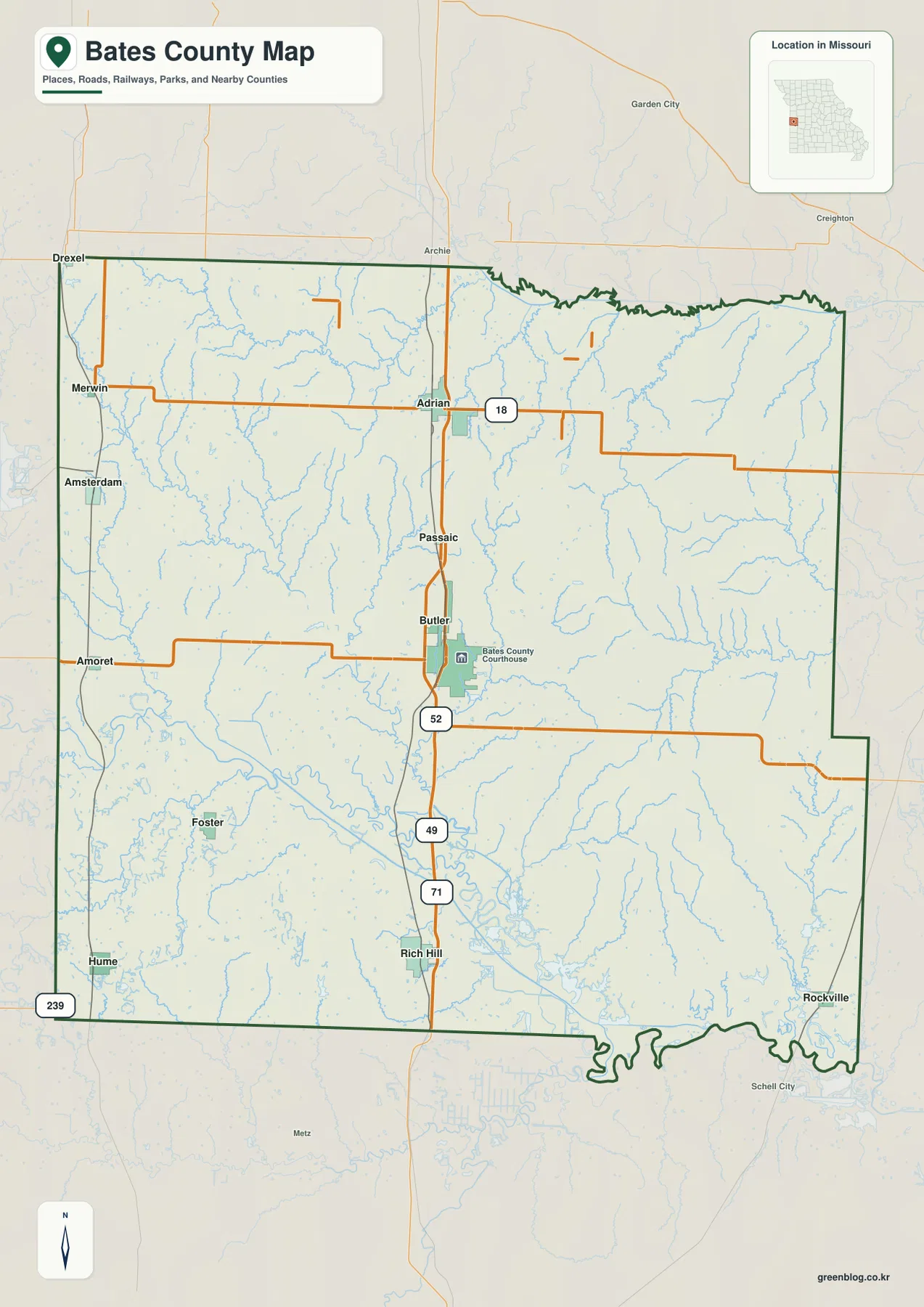
The county is easiest to orient from Butler. Missouri Route 52 crosses the city from west to east, while I-49 and U.S. 71 run south toward Rich Hill. Adrian sits farther north on Route 18, and towns such as Hume, Amsterdam, and Rockville occupy very different edges of the county. Along the south, the Marais des Cygnes River bends into the Osage River system, and the elevation map shows a broad low corridor around those rivers below higher ground in the west and northwest.
Table of Contents
Butler as the practical center of the county road map
Butler is the most useful first landmark on the general county map. It sits a little south of the county’s center and carries the courthouse symbol, making it easy to recognize among the surrounding rural roads. Route 52 crosses Butler from west to east. Just south of the city, I-49 and U.S. 71 form the dominant north-south corridor and continue toward Rich Hill. Once those two directions are established, the rest of Bates County becomes much easier to place.
Adrian appears north of Butler on another clear east-west route, Missouri Route 18. Passaic lies between the two cities along the north-south road corridor. Farther west, Amsterdam and Amoret sit close to the Missouri-Kansas side of the county, with Merwin and Drexel farther north. Hume is near the southwest corner, Foster lies inland from it, and Rockville sits close to the southeastern edge. The map therefore shows a county with one recognizable administrative center but many small settlements distributed across a wide rural area.
The road labels help separate local orientation from long-distance travel. I-49 and U.S. 71 provide the strongest north-south reference, while Routes 18 and 52 give two useful east-west lines through Adrian and Butler. Route 239 is marked near the southwest corner. Smaller roads fill the spaces between these larger routes and reach the scattered towns. This map is useful for geographic orientation, but it is not a live navigation product, so current closures, construction, and driving conditions should be checked with up-to-date road information.
A north-south corridor from Adrian through Butler to Rich Hill
The main settlement pattern becomes clearer when Adrian, Butler, and Rich Hill are viewed as a north-to-south sequence. Adrian stands near Route 18 in the northern part of the county. Butler is farther south where Route 52 provides a second east-west reference. Below Butler, I-49 and U.S. 71 continue toward Rich Hill. These three communities do not form one continuous urban strip, but they give the map a strong central axis that can be used to locate smaller towns on either side.
Western Bates County looks different. Amsterdam and Hume are pushed toward the state-line side, and the smaller towns between them are separated by broad rural spaces rather than a dense road grid. The northwest also includes Drexel and Merwin near the edge of the county. Rockville, by contrast, occupies the southeast, far from the western towns and closer to the lower river country. Those differences matter because a county map can otherwise make scattered communities look closer together than they feel on the ground.
Routes 18 and 52 are particularly helpful because they divide the county into recognizable bands. Route 18 makes Adrian easy to find in the north. Route 52 gives Butler an equally strong east-west position farther south. The interstate and U.S. highway corridor then carries the eye down toward Rich Hill. For a visitor who is unfamiliar with Bates County, remembering those three road references is usually enough to establish a working mental map before looking at smaller roads and streams.
Six-city index: central towns and edge communities
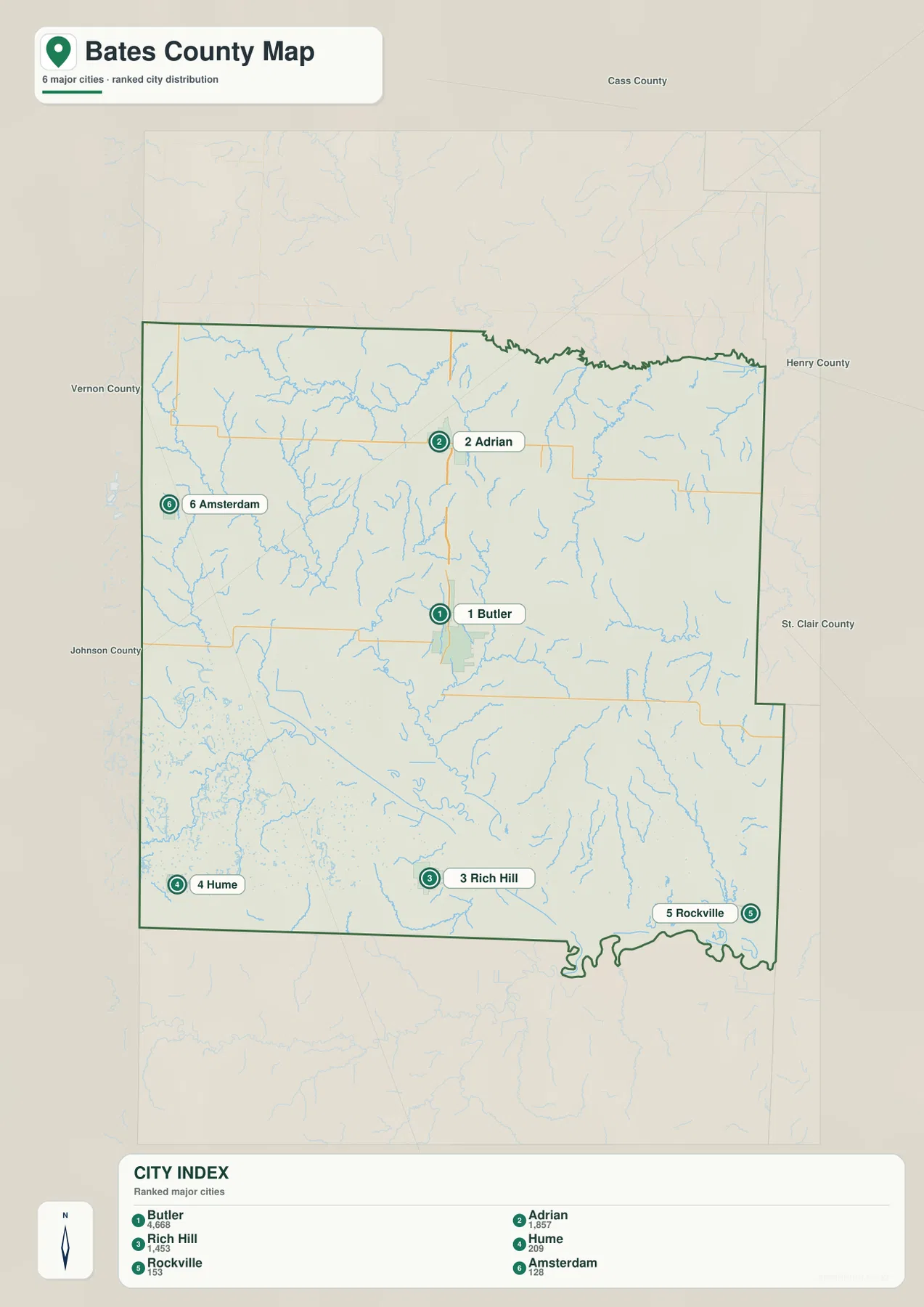
The city map strips away much of the road detail so the spacing among six prominent communities is easier to compare. Butler is numbered first, followed by Adrian and Rich Hill, with Hume, Rockville, and Amsterdam completing the index. Population figures appear on the sheet, but the more useful feature here is location: the map makes the wide separation between central, western, and southeastern towns immediately visible. It is not a complete settlement list, so places such as Amoret, Merwin, Passaic, and Foster are better found on the general county map.
Butler appears near the center, which makes it the easiest reference for all five of the other indexed cities. Adrian is well to the north. Rich Hill lies to the south along the major highway corridor. Hume and Amsterdam both occupy the western side but at different latitudes, while Rockville is far to the southeast. The pattern is more dispersed than clustered, and that is useful to see when preparing a county overview, classroom handout, or regional travel reference.
The simplified city sheet also prevents minor roads from competing with the place labels. That makes directional relationships easier to explain: Adrian is north of Butler, Rich Hill is south, Hume is southwest, Amsterdam is west, and Rockville is southeast. When road access matters, the general map should be used alongside this city index. Together they show both where a community is located and how it relates to the county’s larger transportation network.
The Marais des Cygnes and Osage rivers define the southern lowlands
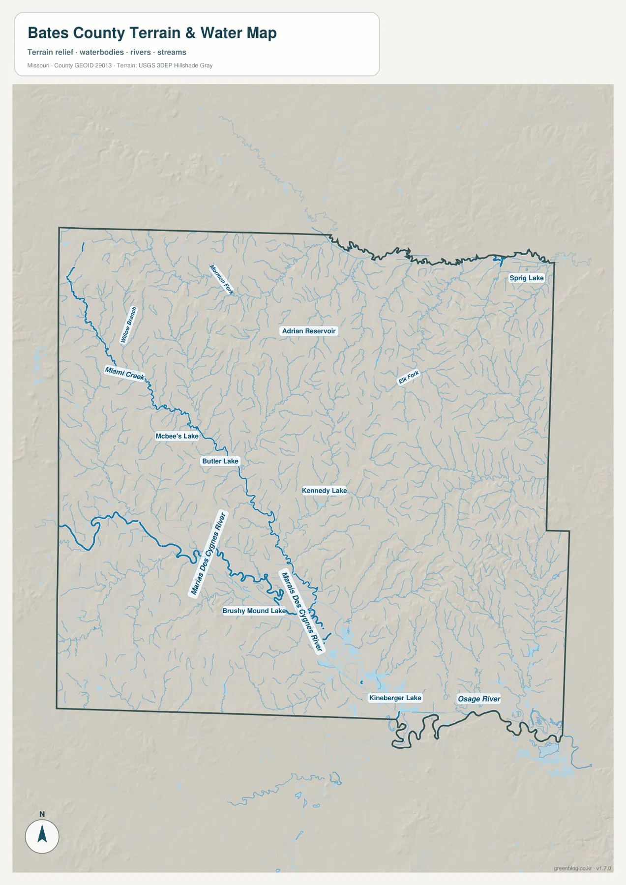
The water map changes the visual emphasis of Bates County. Instead of highways and town labels, a large, winding river corridor dominates the south. The Marais des Cygnes River enters the southern part of the county and continues toward the Osage River system. Numerous smaller tributaries join this corridor, while other creeks branch through the north, west, and east. The result is a much more intricate landscape than the road map alone suggests.
Smaller waters give the county map a second set of landmarks beyond the two large southern rivers. Miami Creek and Willow Branch lie in the northwest, while Adrian Reservoir provides an easy reference near the northern part of the county. Around Butler, Butler Lake and Mcbee’s Lake sit close to the central road network, with Kennedy Lake farther south. Sprig Lake in the northeast and Elk Fork to the east extend that pattern, and Brushy Mound Lake and Kineberger Lake bring it back toward the southern river country. Seen together, these features make it easier to relate the towns to the creeks, reservoirs, and valleys around them.
The broad bends of the Marais des Cygnes River are especially important when the water and elevation maps are compared. The river follows one of the lowest corridors in the county, and many smaller streams descend toward it. The map is intended to show reference hydrography at county scale. It should not be read as a floodplain map, legal water boundary, parcel survey, or navigation chart. Those uses require current specialized data from the appropriate agency.
Higher ground in the northwest, lower valleys along the southern rivers
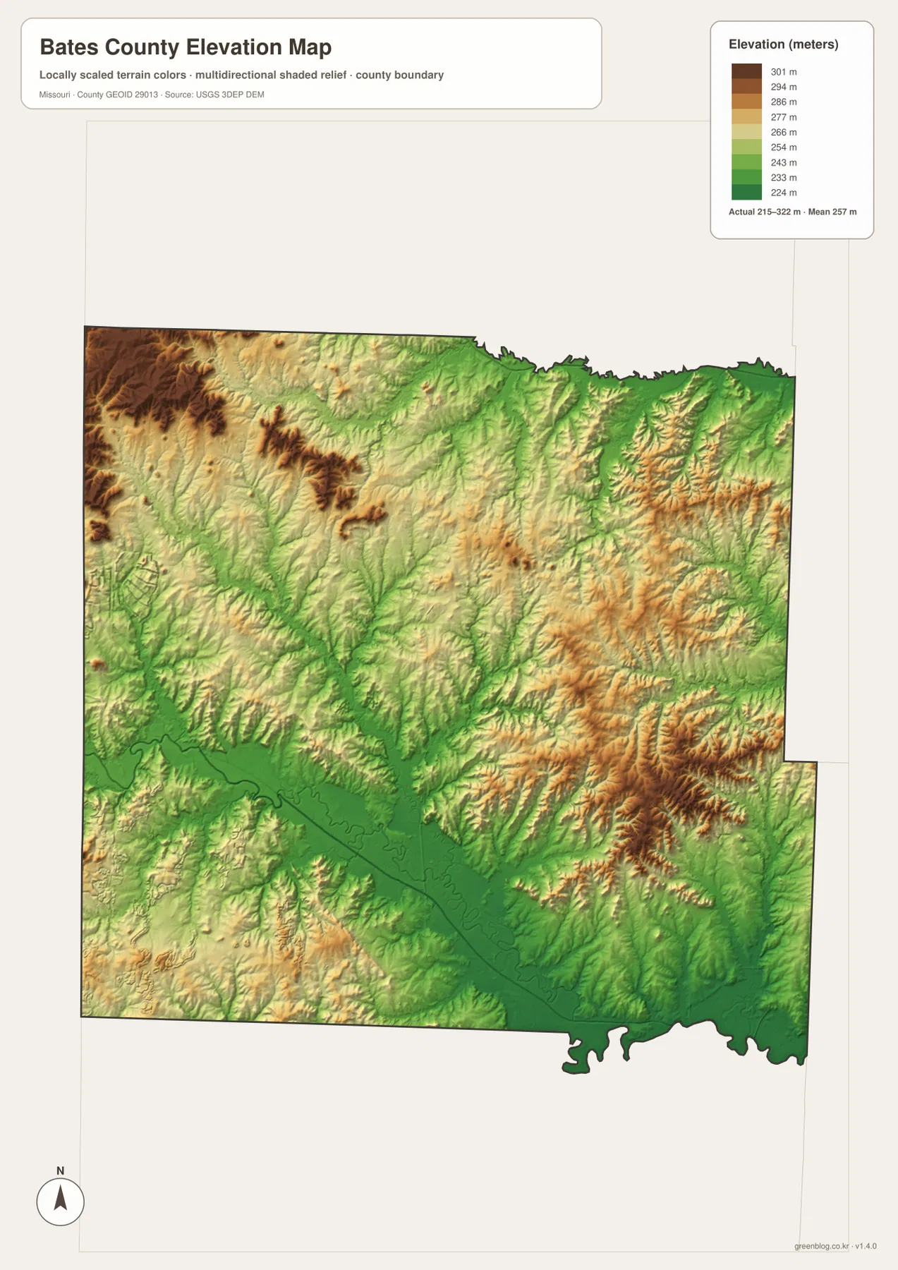
The elevation map gives Bates County a different shape than the road map. Its legend shows an actual range of roughly 215 to 322 meters, with a mean near 257 meters. Browns and oranges indicate relatively higher ground, while greens show lower elevations. The strongest high-ground colors occur in the west and northwest, while the Marais des Cygnes and Osage river corridor forms a broad green lowland across the south.
Eastern Bates County contains a more broken pattern of ridges and narrow valleys. Instead of one continuous high plateau, the colors alternate as small streams cut through the terrain. That relationship is easier to understand after looking at the water map, where tributaries spread across the same area. Near Rockville and the southeastern edge, the land drops toward the larger river system. In the northwest, the higher colors are more extensive and the land appears less dominated by one large valley.
The higher western areas should not be interpreted as mountains. They are simply higher parts of Bates County’s local relief. Likewise, the green southern belt is not perfectly flat; it contains river bends, tributary valleys, and small changes in elevation. This map is designed for county-scale comparison. It is not survey-grade elevation data for a specific property, engineering design, grading plan, or construction decision.
Butler, county history, and the prairie setting west of town
The Bates County courthouse history page states that the county was organized on January 29, 1841, and identifies Butler as the county seat. That background fits the map well: Butler is centrally placed, carries the courthouse symbol, and connects to major roads in several directions. It is not the only important community, but it is the most practical anchor for reading the county as a whole.
Southwest of Butler, Battle of Island Mound State Historic Site adds another layer of local context. Missouri State Parks describes the 1862 engagement there as the first Civil War combat involving Black soldiers, a nationally significant event. The same agency also notes that much of Bates County and southwest Missouri historically supported tallgrass prairie. The historic site is restoring native prairie, which helps explain the open landscape associated with this part of the county.
Those historical and natural details do not replace the geographic evidence in the maps, but they make the western county easier to understand. Broad rural spaces west of Butler are not simply blank areas between town labels. They belong to a landscape shaped by prairie, agriculture, small communities, streams, and gently varying relief. The southern river corridor then introduces a very different lowland character before the county reaches the Osage system.
Choosing the right Bates County map for the task
Use the general county map when roads and towns need to be read together. It is the best sheet for locating Butler, Adrian, Rich Hill, Route 18, Route 52, I-49, and U.S. 71 in one view. The city map is better when the goal is simply to compare the positions of major communities without as much road detail. For example, it makes the separation between Hume in the southwest and Rockville in the southeast immediately clear.
Use the water map when rivers, creeks, reservoirs, and lakes are the subject. The Marais des Cygnes River and Osage River corridor dominates that sheet, while smaller features such as Miami Creek, Adrian Reservoir, Butler Lake, and Elk Fork provide local reference points. Pair it with the elevation map when the question is why some streams occupy broad lowlands and others cut narrower valleys through higher terrain.
For printed work, choosing one map for the specific topic usually produces a clearer result than trying to combine every layer on one page. The supplied JPG files preserve more detail than the WebP previews shown in the article. They are useful for classroom handouts, county overviews, presentations, personal reference, and other situations where labels and linework need to remain readable at larger sizes.
Reading roads, water, and relief together
The maps work best as a set because each one changes what stands out in the same part of Bates County. South of Butler, I-49 and U.S. 71 dominate the general map; switch to the water sheet and smaller tributaries begin to cross that same corridor, with the larger river system farther south. The elevation sheet then shows the land stepping down toward those rivers. Moving between the three views turns a single highway line into a fuller picture of roads, water, and terrain.
The contrast between western high ground and southern lowlands is another good example. Hume and Amsterdam sit toward the western side of the county, where the elevation colors are generally higher than the broad green belt near the Marais des Cygnes River. Rockville lies much closer to the southeastern lowland. Butler occupies an intermediate position, which helps explain why it works so well as a reference point for roads, towns, waterways, and relief.
Adrian also changes character depending on the sheet being viewed. The road map emphasizes Route 18 and the north-south connection toward Butler. The water map adds Adrian Reservoir and a network of nearby streams. The elevation map shows ridges and shallow valleys around those waterways. Looking across the set prevents one layer—roads, water, or elevation—from being mistaken for the whole county landscape.
Frequently Asked Questions
What is the easiest way to locate Butler on the Bates County maps?
On the general map, follow Missouri Route 52 to the city slightly south of the county center. I-49 and U.S. 71 continue south from the Butler area toward Rich Hill, while Adrian lies farther north. On the city index, Butler is marked as number 1, which makes it a quick reference for the other major communities.
Which map best shows the Marais des Cygnes and Osage rivers?
The water map is the clearest choice because it emphasizes the large southern river corridor along with tributaries, lakes, and reservoirs. The elevation map is a useful companion because it shows that the same river corridor occupies some of the lowest ground in the county. Use the general map as well when roads and nearby towns need to be connected to the rivers.
Can the 215–322 meter elevation range be used for a property survey?
No. The elevation sheet is a generalized county-scale surface intended to compare higher and lower terrain. It is not a parcel survey, engineering model, or construction-grade elevation source. Accurate property elevations, boundaries, drainage design, and grading decisions require the appropriate official data and professional field measurements.
Map File Information
The Bates County county map, city map, water map, and elevation map are bundled as the original high-resolution JPG files.
- Included Files: county map, city map, water map, elevation map
- File Type: JPG
Related Maps
Sources and references
- Bates County Courthouse: History – county organization and Butler county-seat background
- Missouri State Parks: Battle of Island Mound State Historic Site – local history southwest of Butler
- Missouri State Parks: Natural Features at Battle of Island Mound – tallgrass prairie context in Bates County
- U.S. Census Bureau TIGER/Line Shapefiles – county boundary and geographic reference data
- USGS National Hydrography – rivers, streams, and water reference data
- USGS 3D Elevation Program – elevation reference data
Green Map creates custom-edited map images using open geographic data sources such as geoBoundaries, Natural Earth, OpenStreetMap, and government open data. These maps are edited visual materials, not raw data files, and are provided for education, documents, presentations, and graphic reference.