Benton County occupies a compact part of central Minnesota where the Mississippi River forms much of the western edge and the St. Cloud urban area reaches into the southwest. Sauk Rapids and Rice sit close to the river and US-10, while Foley and Gilman are farther inland. Moving east from the river, the landscape shifts from low river corridors and developed suburbs to a broader network of streams, rural roads, and higher terrain. High-resolution map files are available for download in the section below.
This page combines a general county map, a hub-city connection map, a water map, and an elevation map with an actual range of roughly 300 to 399 meters. High-resolution A3 JPG originals for all four maps are available together in one ZIP for printing, classroom use, local orientation, and side-by-side geographic comparison.
Table of Contents
Sauk Rapids, Foley, and the county’s southern road network
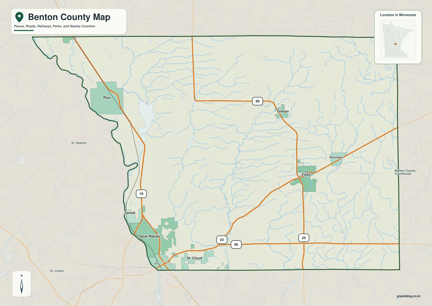
Sauk Rapids is the strongest urban reference on the general county map. It sits on the southwestern side close to St. Cloud, while US-10 follows the western corridor north toward Rice. Because the Mississippi River bends along the same side of the county, the road and river together create a clear north–south orientation for the western communities.
MN-23 provides the main eastward connection from the Sauk Rapids–St. Cloud side toward Foley. Foley sits farther inland where the route meets the north–south MN-25 corridor, giving the city a different road pattern from the Mississippi River communities. Gilman lies north of Foley, while Ronneby appears farther east along another regional route.
Rice is located in the northwest near both US-10 and the Mississippi River. Sartell and Sauk Rapids occupy the lower western edge, where development tied to the St. Cloud area is much denser than in the interior. MN-95 also crosses the southern county, providing another east–west reference below the Foley corridor.
Selected public facilities, including the Benton County Courthouse area, are shown for orientation. The map is not intended to replace a detailed street atlas or live traffic service. Its strongest use is understanding how Sauk Rapids, Rice, Foley, Gilman, and the surrounding rural area connect to the county’s principal highways.
Straight-line connections from the Sauk Rapids hub
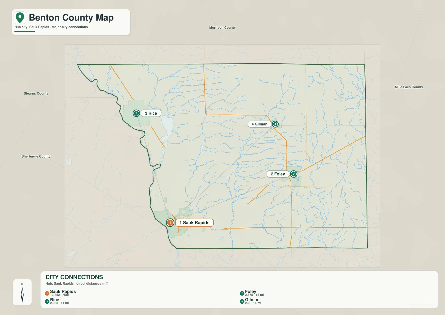
The city connection map uses Sauk Rapids as the hub and compares three other selected communities. Sauk Rapids carries a printed value of 13,852, while Foley is labeled 2,675, Rice 2,085, and Gilman 233. These figures are reproduced from the supplied graphic and are not presented here as newly calculated population estimates.
Unlike a simple ranking index, this map also prints direct distances from the hub. Foley is shown at 13 miles from Sauk Rapids, Rice at 11 miles, and Gilman at 14 miles. These are straight-line distances, not driving mileage, so actual routes can be longer depending on road alignment, river crossings, and the available highway network.
The directions are also useful. Rice lies north of Sauk Rapids along the Mississippi–US-10 corridor, Foley is east in the interior, and Gilman is farther north of Foley. The connection graphic therefore adds a quick sense of both direction and scale that the standard county map does not provide as directly.
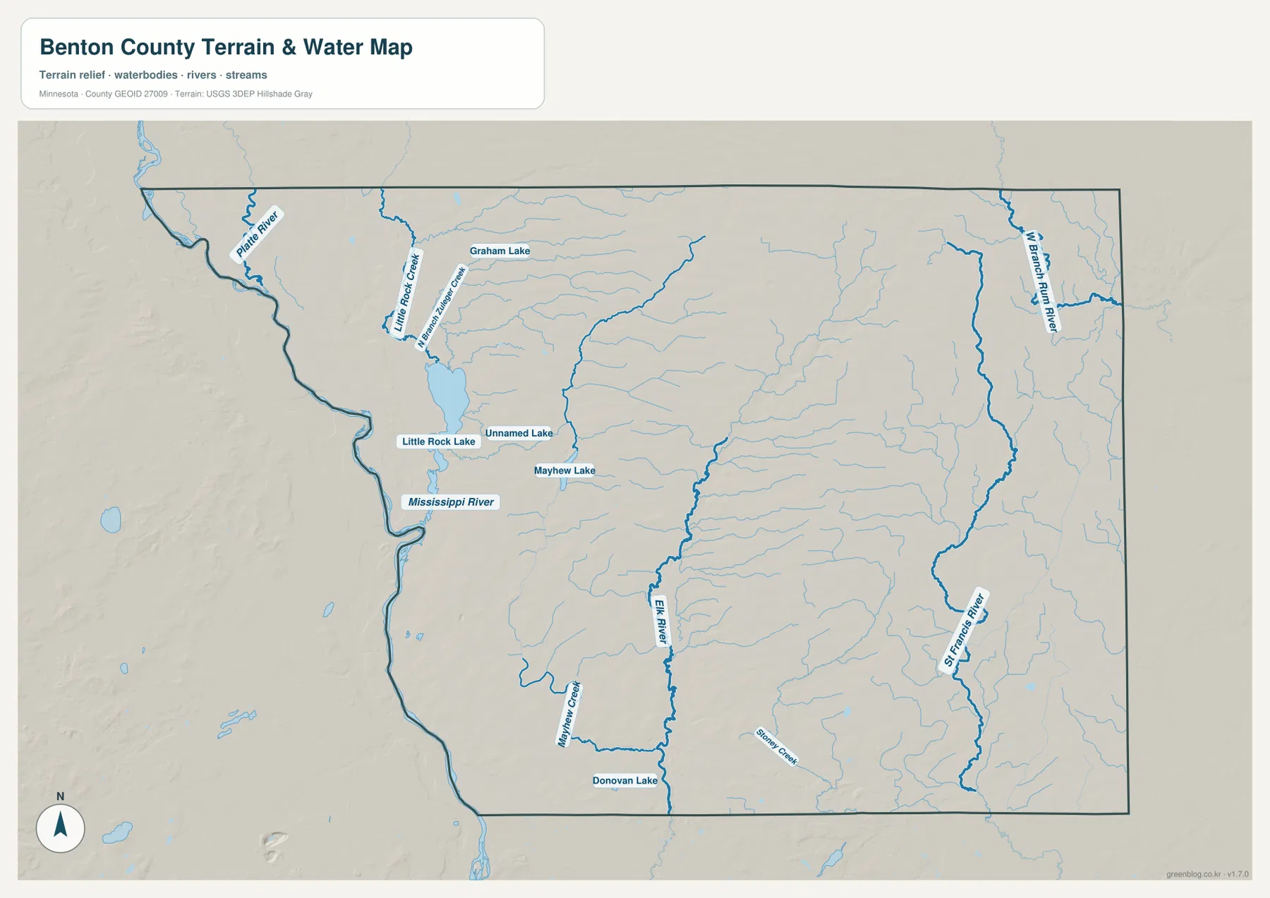
Mississippi River, Little Rock Lake, and the inland stream network
The Mississippi River is the dominant water feature along the western side. It follows a winding county boundary from the Rice area toward Sauk Rapids and St. Cloud, creating a broad low corridor that also shapes the western road pattern. Platte River approaches this river system in the northwest, adding another named waterway near the county edge.
Little Rock Lake sits southeast of Rice and is one of the clearest inland water bodies on the map. Graham Lake lies farther north, while Little Rock Creek and smaller tributaries spread through the same area. Mayhew Lake appears to the east, giving the west-central part of the county a mixture of lakes, creeks, and Mississippi River lowlands.
Elk River runs through the central interior and forms a strong north–south water reference. Mayhew Creek joins the broader drainage pattern to the west, and Donovan Lake is labeled near the southern boundary. Numerous small tributaries feed these channels, so the interior contains more water structure than the simplified road map suggests.
The eastern half contains separate waterways, including St. Francis River and West Branch Rum River, while Stoney Creek appears farther south. Their presence makes it clear that Benton County is not drained entirely through one obvious local stream network. The large Mississippi corridor on the west and the inland eastern rivers create distinct water settings within the same compact county.
Benton and Stearns Counties’ Great River Park Complex plan provides a useful local example of the Mississippi landscape. Bend in the River Regional Park, on the Benton County side near Rice, covers 289 acres and includes Mississippi River shoreline, hiking trails, river overlooks, restored prairie, and a historic farmstead. It connects the broad river corridor visible on the map with a real county recreation area.
Use the water map for names, relative positions, and broad drainage relationships. It does not show flood probability, legal shoreline limits, navigation depth, parcel ownership, or current water conditions. Those questions require current products from the responsible public agency.
Elevation from 300 to 399 meters
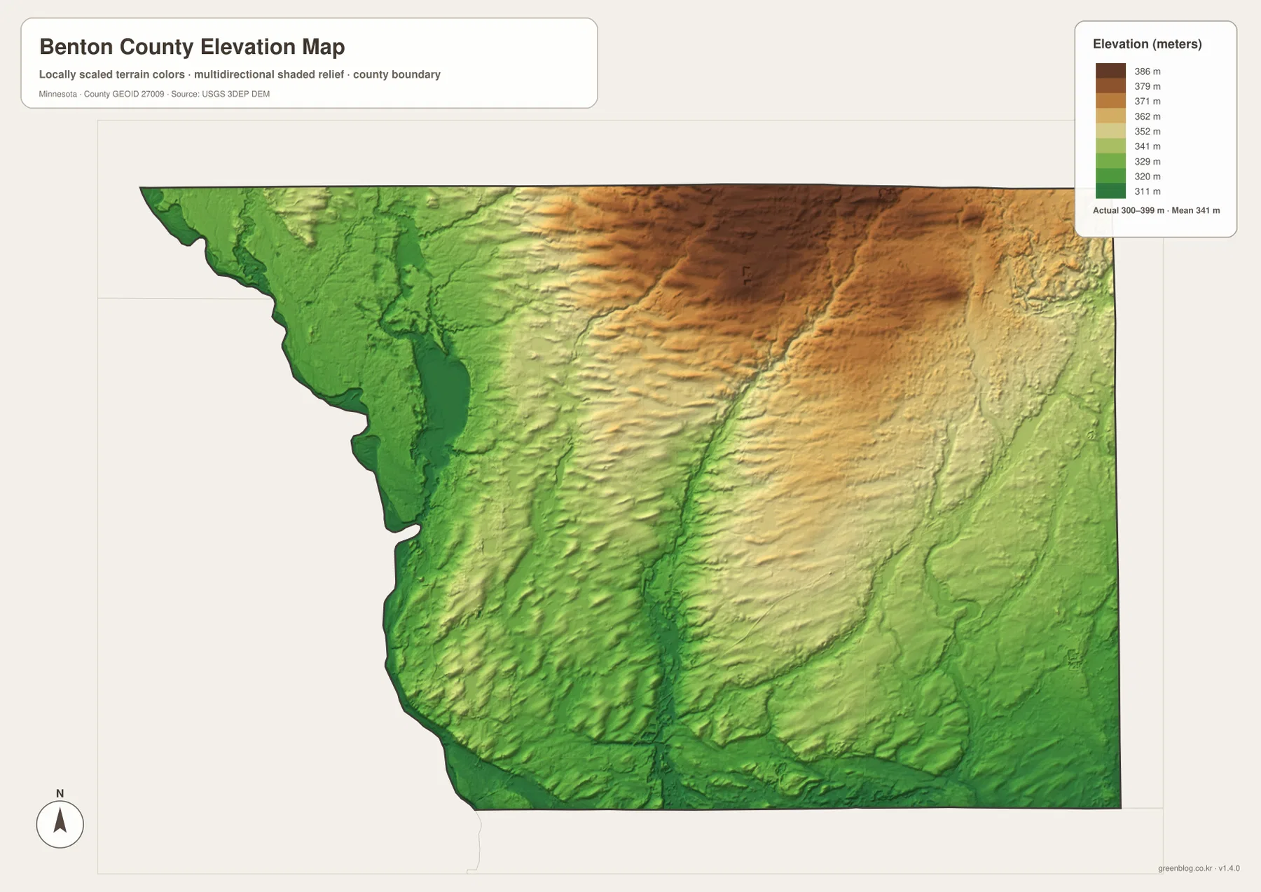
The elevation map reports an actual range of about 300 to 399 meters and a mean near 341 meters. Greens represent lower terrain, while tan and brown colors mark higher ground. The western Mississippi River corridor is the broadest continuous low area, especially around the Rice–Sauk Rapids side of the county.
Elevation rises sharply toward the north-central interior. A broad dark-brown high area occupies much of the upper middle of the county, with smaller valleys cutting south and west from it. This upland stands out clearly against the lower river edge and gives Benton County a stronger internal relief contrast than a road-only map would suggest.
A lower central corridor follows one of the main stream valleys southward through the interior, breaking the high ground into separate areas. The eastern side is generally lower than the north-central high area but remains rolling, while the southern edge returns to broad green lowlands. Comparing the water and elevation maps makes the relationship between streams and lower terrain especially easy to see.
The county-wide difference is roughly 99 meters. That is modest compared with mountain terrain, but it is enough to separate the Mississippi lowlands from the interior uplands and to define stream valleys. This map is intended for broad terrain comparison rather than survey-grade measurement; precise construction, drainage, engineering, or site work requires more detailed official elevation data and field verification.
How Sauk Rapids, Rice, and Foley occupy different settings
Sauk Rapids represents the county’s southwestern urban side. US-10 and MN-23 are close by, the Mississippi River defines the western edge, and the built-up St. Cloud area extends immediately south. The city connection map also makes Sauk Rapids the hub, reinforcing its usefulness as a starting point for understanding the rest of Benton County.
Rice has a more river-oriented setting. US-10 stays close to the Mississippi, Little Rock Lake lies just inland, and the surrounding elevation remains relatively low compared with the northern interior. Bend in the River Regional Park adds another direct connection between this part of the county and the Mississippi shoreline.
Foley is different because it sits away from the main river edge. MN-23 and MN-25 provide its strongest road references, while Elk River and the St. Francis River system shape the surrounding interior. Elevation is generally higher than on the Mississippi side, particularly toward the north-central uplands.
Viewed together, the four maps show a county divided less by long distance than by landscape: a western Mississippi corridor with Sauk Rapids and Rice, an inland road junction at Foley, and a higher northern interior cut by stream valleys. The set works well for general county orientation, school assignments, local-history presentations, and trip preparation, but specialized decisions should rely on current county, state, or federal records.
Frequently Asked Questions
Are the 13 miles to Foley, 11 miles to Rice, and 14 miles to Gilman driving distances?
No. The supplied city connection map labels those values as direct distances from the Sauk Rapids hub, so they are straight-line distances rather than road mileage. Actual driving routes may be longer because of road layout and river crossings.
Which map best shows the relationship between the Mississippi River and Little Rock Lake?
The water map shows both features most clearly. The Mississippi River follows the western county edge, while Little Rock Lake sits inland southeast of Rice; the general county map can then be used to compare the same water features with US-10 and nearby communities.
Can the 300–399 meter elevation range be used for engineering or surveying?
No. The elevation layer is suitable for broad comparison of higher and lower terrain, but precise construction, drainage, engineering, or survey work requires more detailed official elevation data and field verification.
Map File Information
A ZIP containing the high-resolution A3 JPG originals for the Benton County map, city connection map, water map, and elevation map.
- Included Files: county map, city connection map, water map, elevation map
- File Type: JPG
Related Maps
Sources and references
- U.S. Census Bureau TIGER/Line Shapefiles – official geographic files for county boundaries, roads, and place references.
- USGS National Hydrography – federal source for rivers, streams, lakes, and other hydrographic features.
- USGS 3D Elevation Program – official U.S. elevation and terrain data resources.
- Benton County official website – official county government, parks, resident services, and local information.
- Great River Park Complex Master Plan – official Benton and Stearns County planning information for Bend in the River Regional Park and the Mississippi River corridor.
Green Map creates custom-edited map images using open geographic data sources such as geoBoundaries, Natural Earth, OpenStreetMap, and government open data. These maps are edited visual materials, not raw data files, and are provided for education, documents, presentations, and graphic reference.