Anoka County sits immediately north of Minneapolis and Saint Paul, combining a dense southern suburban belt with a much broader northern landscape of rivers, lakes, wetlands, and lower-density communities. Blaine, Coon Rapids, Fridley, and Columbia Heights anchor the south, while St. Francis, East Bethel, Oak Grove, and Columbus occupy more open northern territory. The Rum River, Mississippi River, Coon Lake, and the Rice Creek lake chain make water a major part of the county’s geography. High-resolution map files are available for download in the section below.
This page combines a general county map, a six-city ranking index, a water map, and an elevation map with an actual range of roughly 246 to 339 meters. High-resolution A3 JPG originals for all four maps are available together in one ZIP for printing, classroom use, trip preparation, and side-by-side geographic comparison.
Table of Contents
Blaine, Coon Rapids, and Anoka along the southern transport network
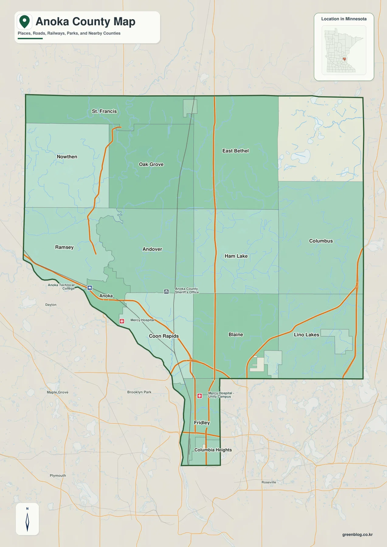
The southern part of the county contains the most concentrated road and settlement pattern. Blaine occupies a broad area in the southeast, Coon Rapids lies closer to the Mississippi River in the southwest, and Anoka sits northwest of Coon Rapids near the meeting of the Rum and Mississippi rivers. Fridley and Columbia Heights extend down the narrow southern section toward the Minneapolis side of the metropolitan area.
US-10 is one of the clearest east–west routes across the southern county, connecting the Anoka and Coon Rapids side with the Blaine corridor. US-169 approaches Anoka from the west, while MN-65 runs north through Blaine toward Ham Lake and East Bethel. The I-35W corridor is visible on the southeastern side near Blaine and Lino Lakes, adding another major connection to the Twin Cities freeway network.
North of Anoka, Ramsey and Andover occupy larger suburban and semi-rural areas. Nowthen, Oak Grove, and St. Francis lie farther north and west, while Ham Lake, Columbus, and East Bethel spread across the eastern half. The spacing between labeled communities increases toward the north, where waterways and open land take up more of the map than the dense street pattern found in the south.
The map includes selected public facilities and surrounding county labels for orientation, but it is not a live navigation product. Its best use is understanding where the main highways pass, how the southern urban belt fits inside the county boundary, and how the northern communities are separated by much broader stretches of land and water.
Six ranked cities concentrated in the southern half
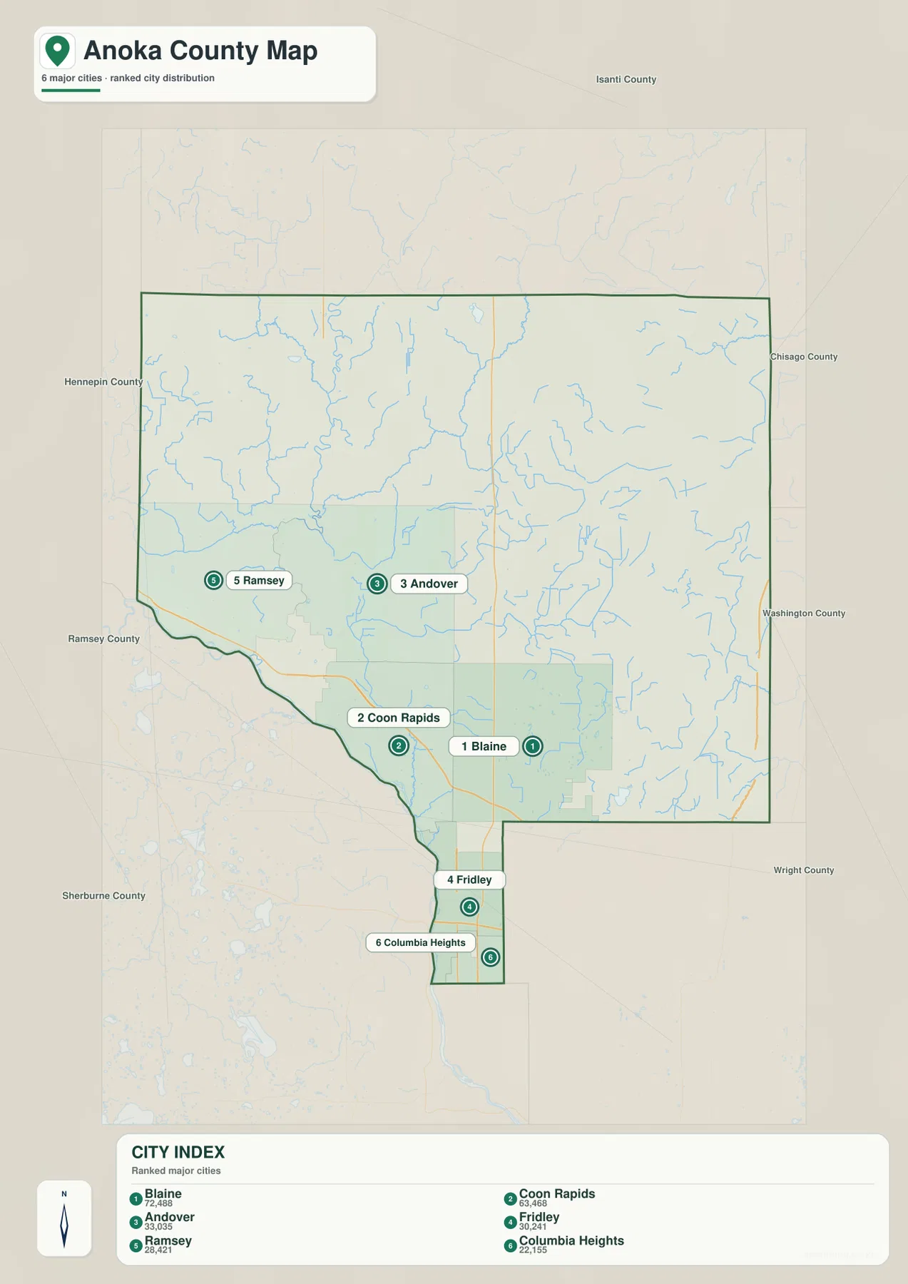
The city index ranks six selected communities. Blaine is number 1 with a printed value of 72,488, followed by Coon Rapids at 63,468, Andover at 33,035, Fridley at 30,421, Ramsey at 28,412, and Columbia Heights at 22,155. These values are reproduced from the supplied city-index graphic and are not presented here as newly calculated population estimates.
Their positions show a strong southern concentration. Blaine is in the southeast, Coon Rapids in the southwest, and Andover directly north of the more urbanized belt. Ramsey sits farther west, while Fridley and Columbia Heights occupy the narrow southern extension of the county. Even without showing every city, the index makes it clear that the largest selected communities are clustered much closer to the Twin Cities than to the county’s northern edge.
There are no connector lines or mileage labels on the city map. It is a ranking and location graphic rather than a distance chart. Use it to compare where the six selected cities sit within the county, then refer to the general road map or a current routing service when actual driving mileage or travel time is needed.
Rum River, Mississippi River, and the eastern lake systems
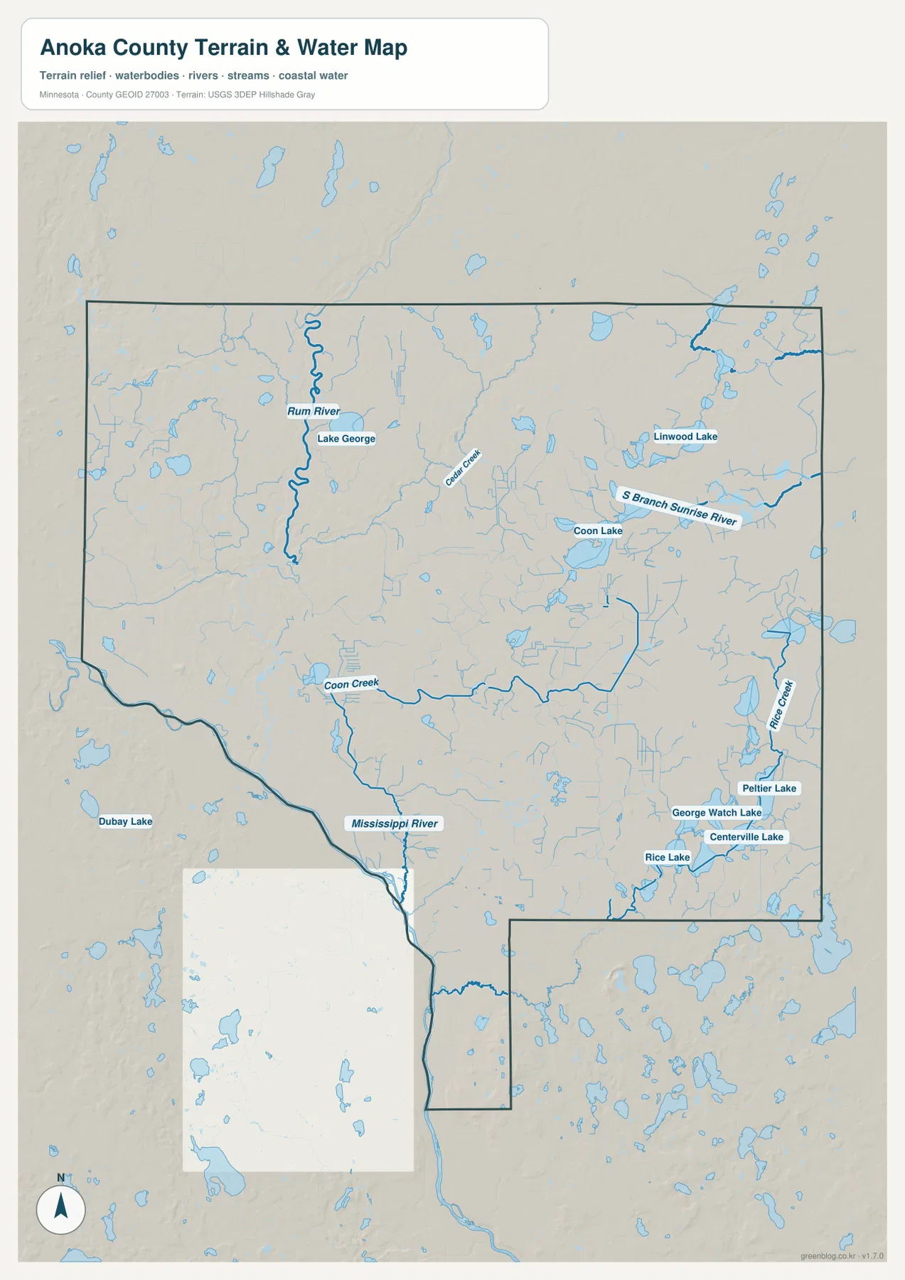
The Rum River is one of the defining waterways on the map. It enters the county from the northwest, bends south past the St. Francis and Ramsey area, and reaches the city of Anoka, where it joins the Mississippi River. The two rivers create the clearest major confluence in the county and provide a natural reference for locating Anoka and the southwestern boundary.
Lake George is labeled near the Rum River in the north, while numerous smaller lakes and tributaries occupy the surrounding landscape. Cedar Creek crosses the north-central area, and Coon Creek extends through the central-southern portion toward Coon Rapids. These waterways make the northern half much more intricate than a road-only view suggests.
Coon Lake is the most prominent named lake in the east-central county, with Linwood Lake farther northeast. The South Branch Sunrise River runs through the same broad area, and many smaller channels and lakes fill the eastern side. Toward the southeast, Rice Creek is joined by a cluster that includes Peltier Lake, George Watch Lake, Centerville Lake, and Rice Lake around the Lino Lakes–Centerville area.
Anoka County Parks gives the Rum River a direct recreation connection. The county describes Rum River North County Park in St. Francis as the northern access to the Rum River Canoe Corridor, which passes Rum River Central Regional Park and ends at Rum River South County Park in Anoka. That official corridor closely follows the long north–south river visible on the water map.
Use this layer for names, relative positions, and broad drainage relationships. It does not show flood probability, legal shoreline limits, navigation depth, parcel ownership, or current water conditions. Those questions require current products from the responsible public agency.
Elevation from 246 to 339 meters
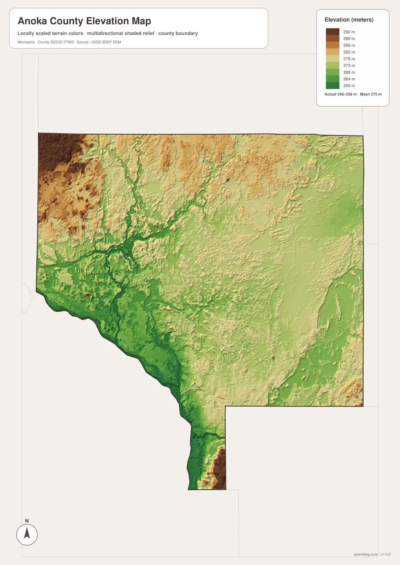
The elevation map reports an actual range of about 246 to 339 meters and a mean near 275 meters. Greens represent lower terrain, while tan and brown colors mark higher ground. The Rum and Mississippi river lowlands in the southwest are among the broadest continuous low areas, and other stream valleys appear as narrow green corridors cutting through the county.
The highest terrain is concentrated near the northwestern edge, where darker brown relief rises above the interior. Moving east and south from that corner, elevation generally drops and the landscape becomes more mixed. The Rum River and its tributaries carve lower paths through this higher northern terrain on their way toward Anoka.
The central and eastern portions combine gently rolling land with many low lake and stream basins. Coon Lake, Linwood Lake, and the Rice Creek lake chain occupy visibly lower settings. The narrow southern section around Fridley and Columbia Heights also contains short, sharp changes in relief, so the metropolitan part of the county is not completely flat even though it sits lower than much of the northwest.
A county-wide difference of roughly 93 meters is modest compared with mountainous regions, but it is enough to make river valleys, lake basins, and the northwestern uplands stand out. This surface is intended for broad terrain comparison rather than survey-grade measurement. Construction, drainage, engineering, and site work require more detailed official elevation data and field verification.
Why the southern suburbs and northern lake country feel different
Blaine and Coon Rapids show the metropolitan side of Anoka County most clearly. US-10, MN-65, and other major roads are closely spaced, large city areas touch one another, and streams such as Coon Creek pass through developed land. On the elevation map, this southern belt is generally lower and smoother than the county’s northwestern uplands.
Anoka and Ramsey add the county’s major river setting. The Rum River approaches from the north and meets the Mississippi at Anoka, giving the western urban area a stronger river identity than the Blaine side. The county’s chain of Rum River parks and canoe corridor follows the same direction north toward St. Francis, linking the city area with a much more open landscape.
East Bethel, Ham Lake, Columbus, and Lino Lakes show another pattern. Lakes and smaller channels become much more numerous, Coon Lake and Linwood Lake provide large water references, and the Rice Creek system connects a dense group of southeastern lakes. The contrast between these water-rich outer communities and the southern urban belt is one of the clearest reasons to compare all four maps together.
The map set works well for general county orientation, school assignments, local-history presentations, and trip preparation. It does not replace parcel records, zoning documents, flood-regulation products, legal surveys, or real-time transportation information, so specialized decisions should rely on current county, state, or federal sources.
Frequently Asked Questions
Which maps best show the difference between Blaine and Coon Rapids?
Start with the general county map for their positions and the US-10 corridor, then compare the water map. Coon Rapids is much closer to the Mississippi River, while the Blaine side connects more directly with the Rice Creek and eastern lake systems.
Are the city-index values current population estimates?
The values described here are the numbers printed in the supplied city-index graphic. For the latest population figures, use current U.S. Census Bureau or Anoka County statistics rather than treating the map values as a new estimate.
Can the 246–339 meter elevation range be used for engineering or surveying?
No. The elevation layer is suitable for broad comparison of higher and lower terrain, but precise construction, drainage, engineering, or survey work requires more detailed official elevation data and field verification.
Map File Information
A ZIP containing the high-resolution A3 JPG originals for the Anoka County map, city index, water map, and elevation map.
- Included Files: county map, city index map, water map, elevation map
- File Type: JPG
Related Maps
Sources and references
- U.S. Census Bureau TIGER/Line Shapefiles – official geographic files for county boundaries, roads, and place references.
- USGS National Hydrography – federal source for rivers, streams, lakes, and other hydrographic features.
- USGS 3D Elevation Program – official U.S. elevation and terrain data resources.
- Anoka County official website – official county government, resident services, and local information.
- Anoka County Parks and Recreation – official information about county parks and recreation resources associated with the Rum River, Mississippi River, and local lakes.
Green Map creates custom-edited map images using open geographic data sources such as geoBoundaries, Natural Earth, OpenStreetMap, and government open data. These maps are edited visual materials, not raw data files, and are provided for education, documents, presentations, and graphic reference.