Isabella County sits in central Michigan’s Lower Peninsula, but the county is easier to understand when Mount Pleasant is treated as a reference point rather than as the whole story. Rosebush lies to the north, Shepherd to the southeast, and a more dispersed set of communities—including Beal City, Weidman, and Lake Isabella—occupies the western half. The maps below separate those relationships into roads and settlements, hub-to-community distances, waterways, and elevation. Matching high-resolution JPG versions are also available together in the downloadable ZIP.
The contrast between east and west becomes clearer as the map theme changes. Mount Pleasant has the most obvious concentration of streets and major routes, while the western interior is marked by smaller communities, named lakes, and more broken relief. The Chippewa River crosses the middle of the county, and the elevation image shows higher ground along much of the western edge falling toward broad lower terrain around and east of Mount Pleasant. Looking at those elements together is more useful than treating Isabella County as a uniform rectangular area.
Table of Contents
Mount Pleasant and the M-20 corridor provide the clearest eastern reference point
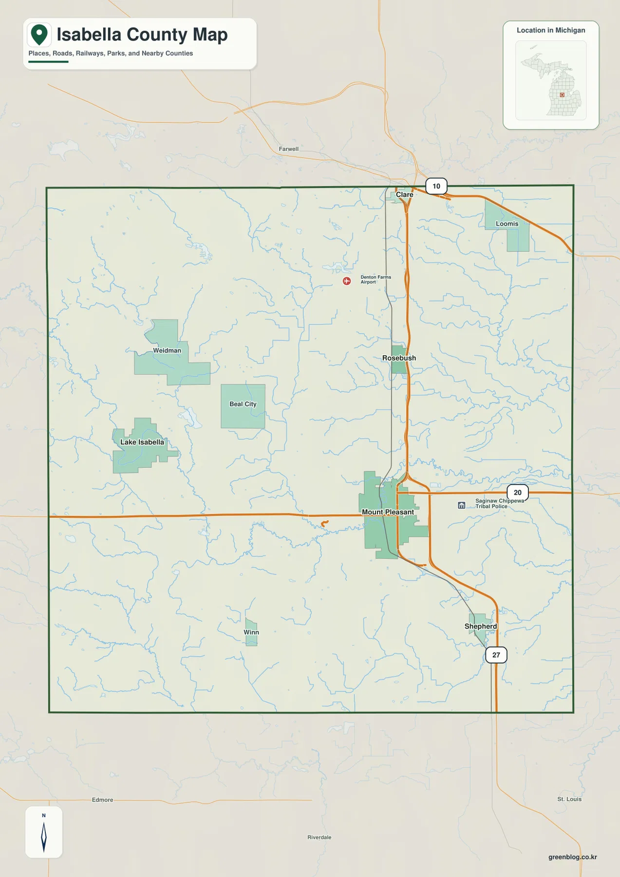
On the general county map, Mount Pleasant stands out as the largest built-up area and the place where the major road pattern is easiest to read. M-20 runs east-west through the city, while a prominent north-south route passes through the same area and continues toward Rosebush and beyond. Shepherd lies southeast of Mount Pleasant. Together, those three places make the eastern half of the county relatively easy to orient because each can be described in relation to the Mount Pleasant road network.
The western half is more dispersed. Beal City lies inland between Mount Pleasant and the western communities, Weidman is farther northwest, and Lake Isabella is positioned still farther west. Winn appears as a smaller settlement in the southwest. There is no single western town that visually dominates the map in the way Mount Pleasant does, so local roads, streams, and lakes become more important reference features when moving away from the eastern hub.
Clare is shown just beyond the northern county boundary, giving another useful external reference for the road continuing north past Rosebush. South of Mount Pleasant, the route toward Shepherd continues out of the county. The map is not a parcel or legal-boundary product, but it works well for county-scale orientation: first locate Mount Pleasant, then decide whether the destination lies toward Rosebush, Shepherd, or the more widely spaced western communities.
The city-connection map turns the west, north, and southeast directions into simple distance comparisons
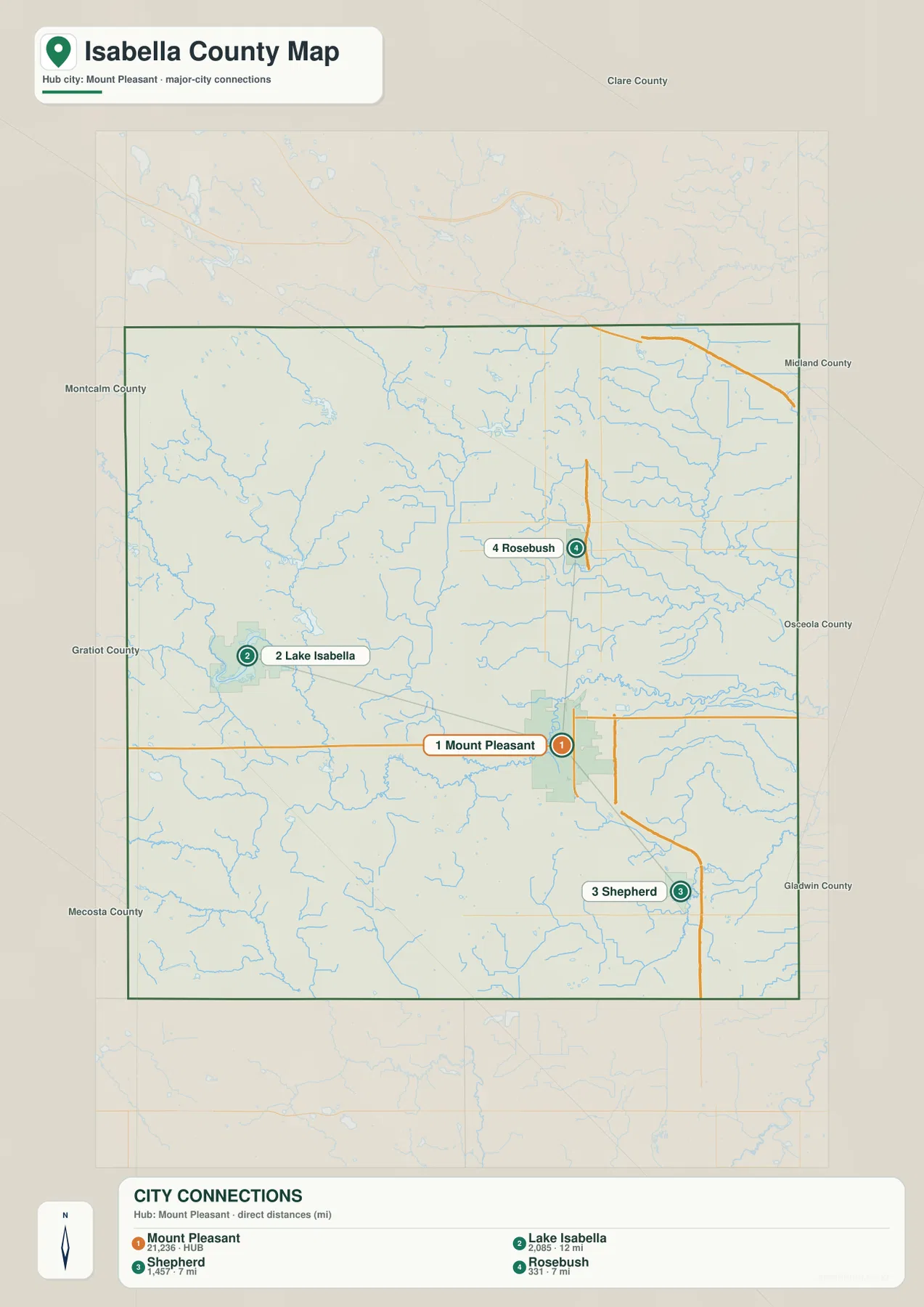
The city-connection map uses Mount Pleasant as the hub and links it to Lake Isabella, Shepherd, and Rosebush. The graphic is intentionally simpler than the general map: instead of asking the reader to follow every local road, it emphasizes the direction and separation of the three selected communities. Lake Isabella is west of the hub, Shepherd is southeast, and Rosebush is north.
The printed distances are about 12 miles from Mount Pleasant to Lake Isabella and about 7 miles to both Shepherd and Rosebush. These are straight-line distances, not driving distances. Roads do not necessarily follow those connectors, so the values should not be used to estimate travel time. They are most useful for showing that Lake Isabella is noticeably farther from the hub while Shepherd and Rosebush sit at similar distances on different sides of Mount Pleasant.
Not every important western place is part of the connector set. Weidman and Beal City remain visible on the general county map but are not linked from the hub on this diagram. Reading the two maps together fills that gap: once the westward direction toward Lake Isabella is established, Beal City can be located between the western communities and Mount Pleasant, while Weidman sits farther to the northwest. That makes the western settlement pattern look less like a corridor and more like a group of separate local centers.
The Chippewa River crosses the middle while separate river systems occupy the eastern and southwestern edges
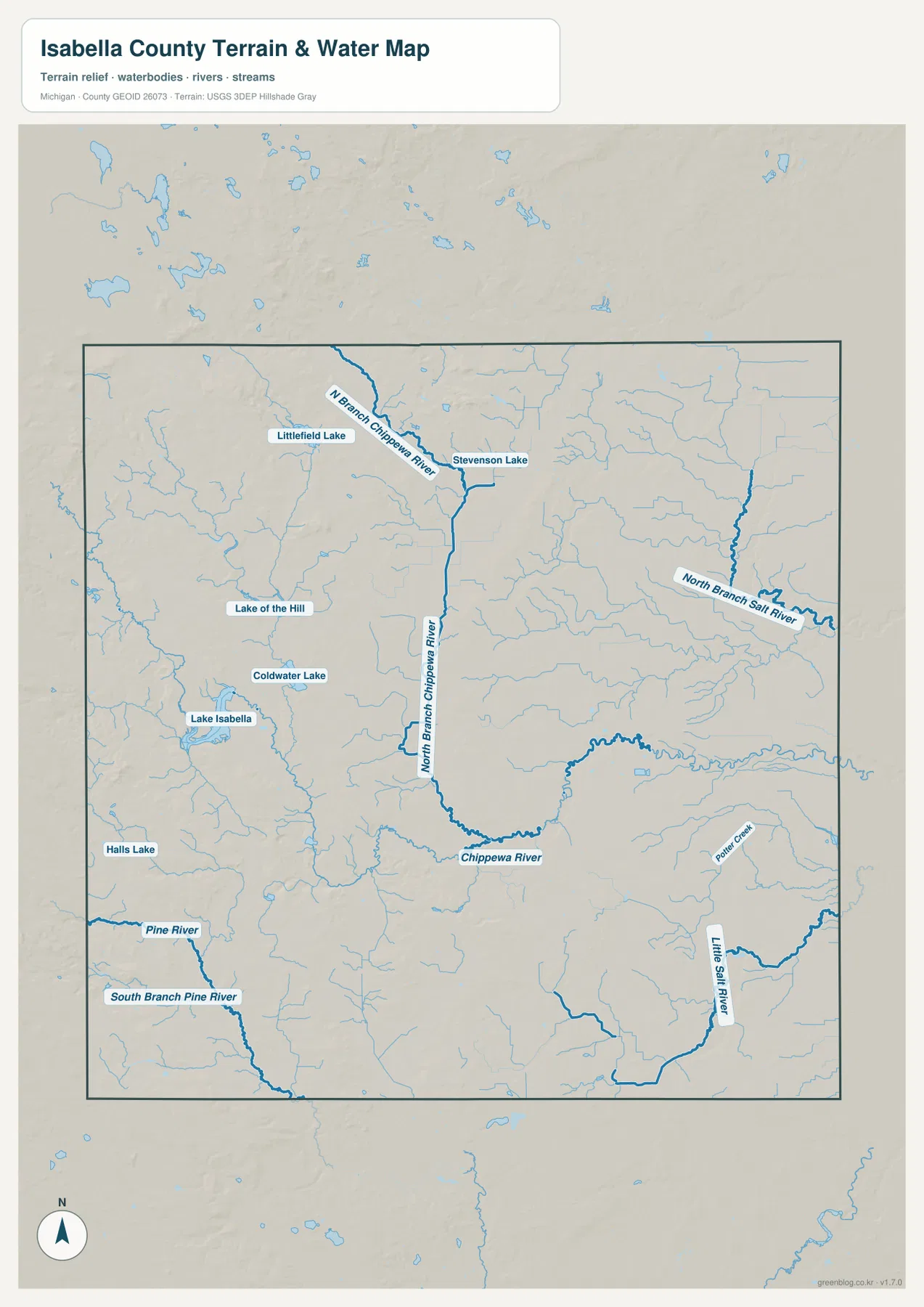
The terrain-and-water map gives Isabella County a different structure from the road map. The Chippewa River bends across the central part of the county, and the North Branch Chippewa River approaches from the north before joining that central network. Numerous smaller streams feed the system, so the middle of the county is not defined by one isolated blue line but by a branching set of waterways that helps explain the shape of the low ground seen on the elevation image.
Named lakes are especially useful in the west. Lake Isabella is the most prominent landmark, while Coldwater Lake, Lake of the Hills, Littlefield Lake, and Stevenson Lake appear farther north and northeast. Halls Lake is shown separately in the southwest. These waters are not one continuous lake chain, but together they provide strong local reference points in an area where the towns are smaller and more widely spaced than they are around Mount Pleasant.
Other waterways define the county edges. North Branch Salt River appears in the northeast, Little Salt River and Porter Creek in the southeast, and the Pine River with its South Branch in the southwest. That distribution matters because it prevents an oversimplified reading in which every stream is assumed to belong to the Chippewa River. A better mental picture is a central Chippewa system with different drainage names toward the east and southwest.
This water map is a geographic reference, not a flood, navigation, fishing-regulation, or property-access map. A stream symbol does not establish current depth or public access, and lake outlines do not substitute for current water-management information. Its strongest use is to show where the named rivers and lakes sit relative to communities such as Lake Isabella, Weidman, and Mount Pleasant.
Western ridges rise well above the broad lower terrain around Mount Pleasant and the eastern county
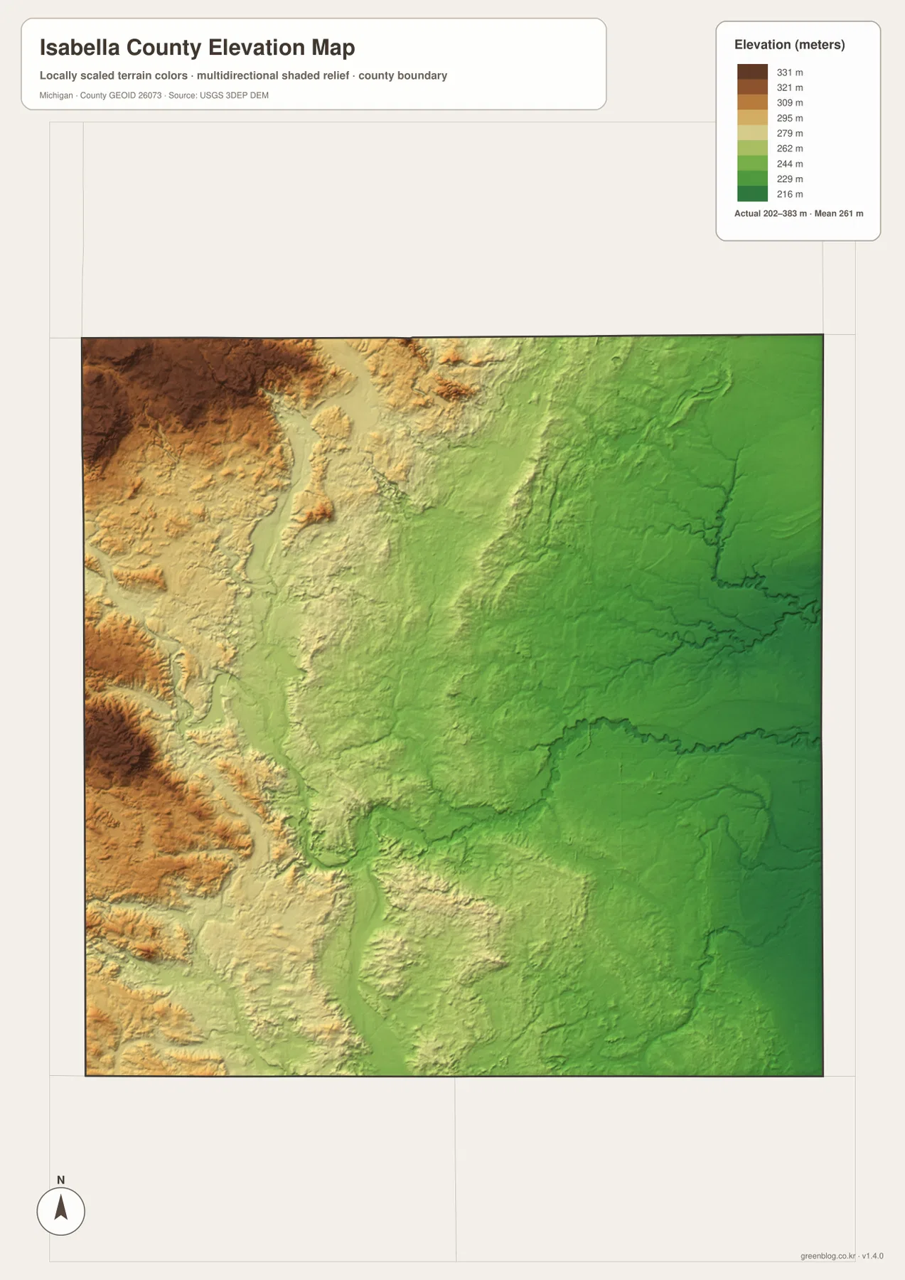
The elevation map reports an actual county-wide range of roughly 202 to 383 meters, with a mean near 261 meters. Browns and tans represent higher ground, while greens indicate lower elevations. The strongest pattern is immediately visible: the western county edge contains the highest terrain, and the surface generally steps down toward the center and east.
The western high ground is not a single flat plateau. Narrow lower valleys cut between the ridges, and smaller rises continue into the central part of the county. Those changes align with the branching streams seen on the water map. Lake Isabella sits near a transition between the more rugged western side and lower central terrain, while the Mount Pleasant area lies in a noticeably greener, lower part of the elevation image.
Large green areas dominate the eastern half, although local ridges and stream valleys still break the surface. The contrast is therefore regional rather than absolute: west is generally higher, east is generally lower, and the middle contains a gradual mixture of both. This helps distinguish rural areas that may look similar on the road map but occupy different topographic settings.
The elevation surface is generalized for county-scale viewing and should not be treated as survey-grade or engineering-grade measurement. The 202–383 meter range describes the terrain represented on the map, not the precise elevation of a specific house, road shoulder, or construction site. Detailed work should use current USGS elevation data or a professional survey.
Roads, water, and relief can be combined to narrow down a place without relying on one label
Mount Pleasant is easy to identify from roads alone, but western places benefit from a second or third reference. Lake Isabella, for example, can first be located west of Mount Pleasant on the county map, then confirmed by the lake shape on the water map, and finally placed near the transition from western higher ground toward lower central terrain. That sequence is useful when a road label is too small or when several rural roads look alike.
Weidman can be approached in a similar way. It is northwest of Lake Isabella on the general map and lies in the western part of the county where named lakes and branching streams are more prominent. Shepherd requires a different set of clues: it lies southeast of Mount Pleasant in the lower eastern half, away from the western lake concentration. Comparing themes makes those distinctions clearer than memorizing a long list of place names.
The downloadable archive contains four high-resolution JPG maps matching the themes shown in the article. The general map is best for communities and roads, the city-connection graphic for hub direction and straight-line distance, the water map for rivers and lakes, and the elevation map for broad relief. The larger JPG files are useful when small labels need to be enlarged or when a printed copy is more convenient than the web images.
Frequently Asked Questions
Is Lake Isabella west of Mount Pleasant?
Yes. The general map places Lake Isabella west of Mount Pleasant, and the city-connection map shows the two locations about 12 straight-line miles apart. Beal City lies in the western interior between the Mount Pleasant area and the farther-west communities, while Weidman is northwest of Lake Isabella.
Do the 7-mile and 12-mile city connections represent driving distance?
No. The connectors show straight-line distance from Mount Pleasant: about 12 miles to Lake Isabella and about 7 miles to both Shepherd and Rosebush. Actual road distance can be longer and depends on the route, so current navigation data should be used for trip planning.
What does the 202–383 meter elevation range mean?
It is the approximate actual elevation range represented by the county-scale elevation map. The western edge contains much of the higher terrain, while Mount Pleasant and much of the eastern county sit lower. The map is useful for regional comparison but is not a substitute for a survey or site-specific engineering data.
Where are Lake Isabella and Shepherd relative to Mount Pleasant?
The city-connections map places Lake Isabella about 12 miles west of Mount Pleasant and Shepherd about 7 miles to the southeast. Those values are straight-line distances rather than road mileage. Driving distance and travel time depend on the exact starting point and chosen route, so current navigation information should be used for trip planning.
Which map is best for finding the Chippewa River and Lake Isabella together?
The terrain-and-water map is the clearest choice because it labels the Chippewa River, North Branch Chippewa River, Lake Isabella, Coldwater Lake, Pine River, and other water features directly. If roads and communities are also important, compare it with the general county map to see how the lake and river system relate to Mount Pleasant, Weidman, Beal City, and the surrounding road network.
What files are included in the Isabella County map download?
The ZIP contains four high-resolution JPG files: the general county map, the city-connections map, the terrain-and-water map, and the elevation map. Each image is 3638 × 2572 pixels. The water image is not intended for flood or navigation decisions, and the elevation image is not survey-grade, so specialized work should rely on the appropriate current official source.
Map File Information
Download the map files associated with this page for reference, printing, and compatible visual projects.
- Included Files: Use only the versions confirmed in the article and supplied images
- File Type: Use the confirmed download contents
- Intended Use: Printing, education, presentations, and map-based projects
Related Maps
Sources and References
The resources below provide county background, current statistics, and authoritative boundary, hydrography, and elevation data. The maps on this page are intended for county-scale geographic reference; legal boundaries, flood conditions, exact elevations, and other specialized decisions should be checked against the latest purpose-specific source.
- Isabella County official overview – county background and local information
- U.S. Census Bureau QuickFacts: Isabella County, Michigan – population and county statistics
- U.S. Census Bureau TIGER/Line Shapefiles – county boundary and geographic data
- USGS National Hydrography – rivers, streams, lakes, and hydrography data
- USGS 3D Elevation Program – elevation data
Green Map creates custom-edited map images using open geographic data sources such as geoBoundaries, Natural Earth, OpenStreetMap, and government open data. These maps are edited visual materials, not raw data files, and are provided for education, documents, presentations, and graphic reference.