Madison Parish occupies Louisiana’s northeastern edge, where Tallulah and the I-20/U.S. 80 corridor lead east toward the Mississippi River. Richmond sits close to Tallulah, while Mound and Delta lie farther along the same general eastward route. West of the main settlement corridor, the map becomes much more open and is crossed by local roads, bayous, oxbow-like water features, and small lakes. This page explains those visible relationships with the supplied general, ranked-city, and terrain-and-water maps. Matching high-resolution JPG originals are available together in a downloadable ZIP.
Tallulah is the parish seat and the strongest place to use for orientation. Louisiana’s official Madison Parish profile identifies Tallulah as the city in the parish and lists Delta, Mound, and Richmond as villages. On the supplied map, Tallulah has the largest developed footprint, Richmond is immediately to its southeast, and Mound and Delta continue toward the Mississippi River. Locating those four places first makes the highway corridor, river boundary, and less-developed western half much easier to understand.
Table of Contents
The main settlement corridor runs east from Tallulah toward Delta
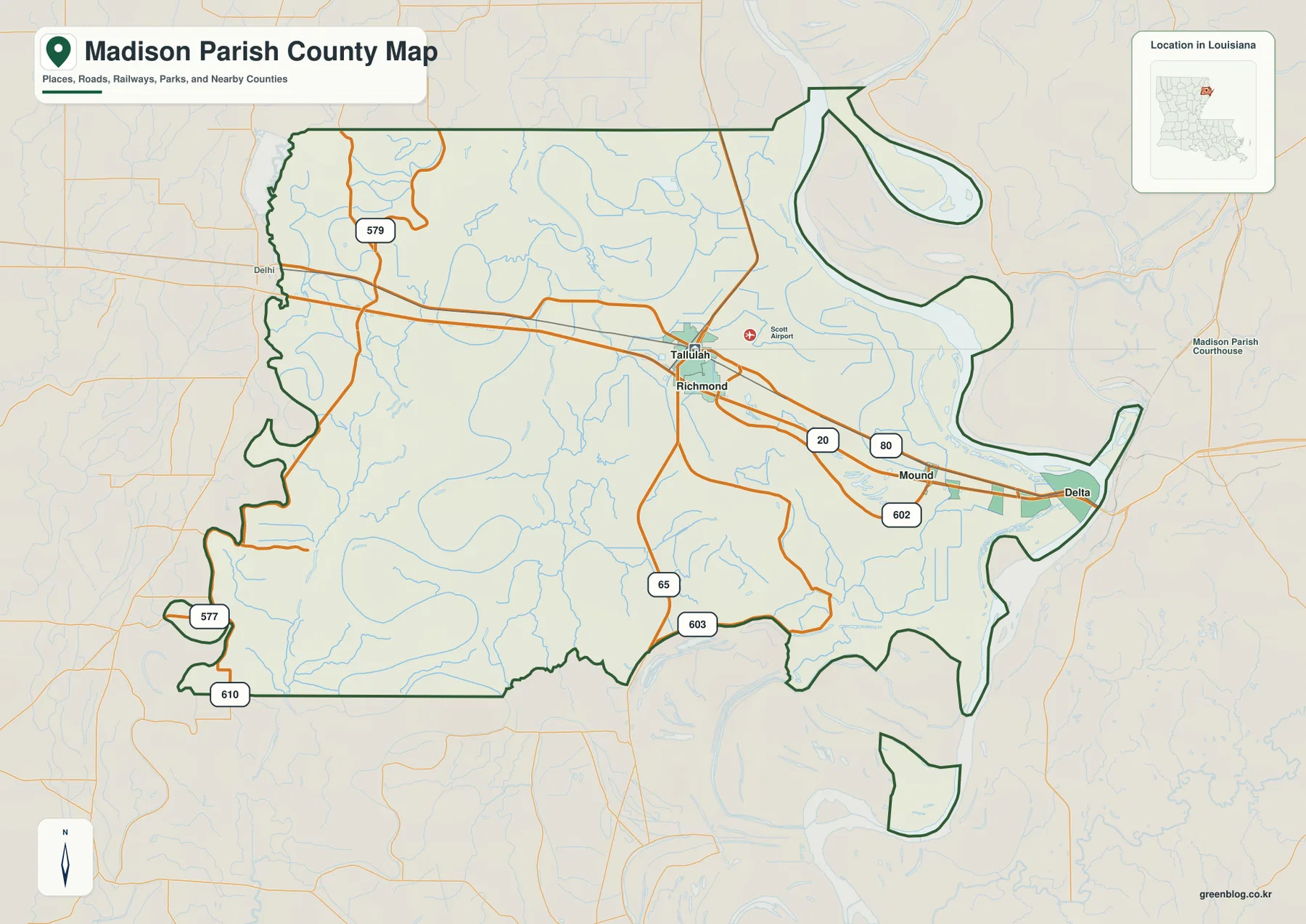
The general map places Tallulah slightly east of the parish center, with I-20 and U.S. 80 forming the clearest east-west transportation references. Richmond lies very close to Tallulah, while Mound and Delta are progressively farther east toward the river. LA 602 is labeled around the Mound area, and LA 65 and LA 603 extend south from Tallulah. That arrangement makes the central-eastern part of Madison Parish easy to read as a connected corridor rather than as a group of isolated settlements.
The western half has a different character. LA 579 appears in the northwest, while LA 577 and LA 610 are shown farther south and west. There are fewer large settlement labels, and small waterways occupy much more of the map. This contrast is useful when judging the scale of the parish: the Tallulah–Delta corridor is the most obvious transportation zone, but it represents only part of a much broader landscape extending westward.
The Mississippi River creates a highly irregular eastern boundary
The eastern edge of Madison Parish follows large bends of the Mississippi River instead of a straight administrative line. A broad loop appears in the northeast, and the boundary curves again around the Delta area before continuing south. The shape is one of the parish’s most distinctive map features because it makes the eastern side look very different from the straighter northern and southern segments.
I-20 and U.S. 80 approach the river from Tallulah and continue toward the state line, so roads and water provide complementary reference points in this part of the map. Scott Airport is also labeled just east of Tallulah. Close to the Mississippi River, however, waterways and irregular boundary segments become more useful than urban blocks for understanding where the parish ends and the opposite bank begins.
The ranked city map simplifies Madison Parish to four main settlements
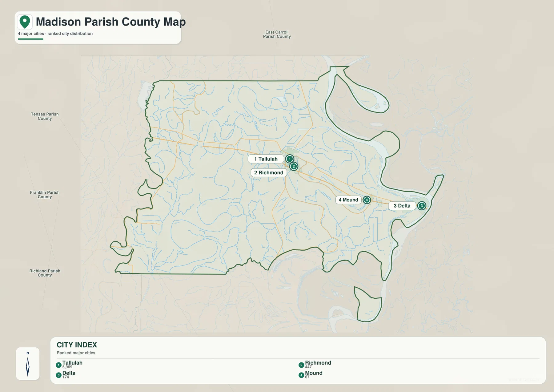
The city graphic is a ranked distribution map, not a hub-and-distance diagram. Tallulah is number 1, Richmond number 2, Delta number 3, and Mound number 4. Tallulah and Richmond appear close together, while Mound and Delta are positioned farther east. The compact graphic makes it easy to see that the selected settlements are concentrated in the central and eastern portion of Madison Parish rather than spread evenly across the entire parish.
The numbers should not be read as distance labels. They represent the order used in the city index, while the general parish map contains the broader road network, neighboring place labels, and smaller geographic details. Use the ranked city view when a presentation or lesson only needs the relative positions of the four selected settlements; use the general map when roads and parish boundaries also matter.
The Tensas River and bayous dominate the western and central water network
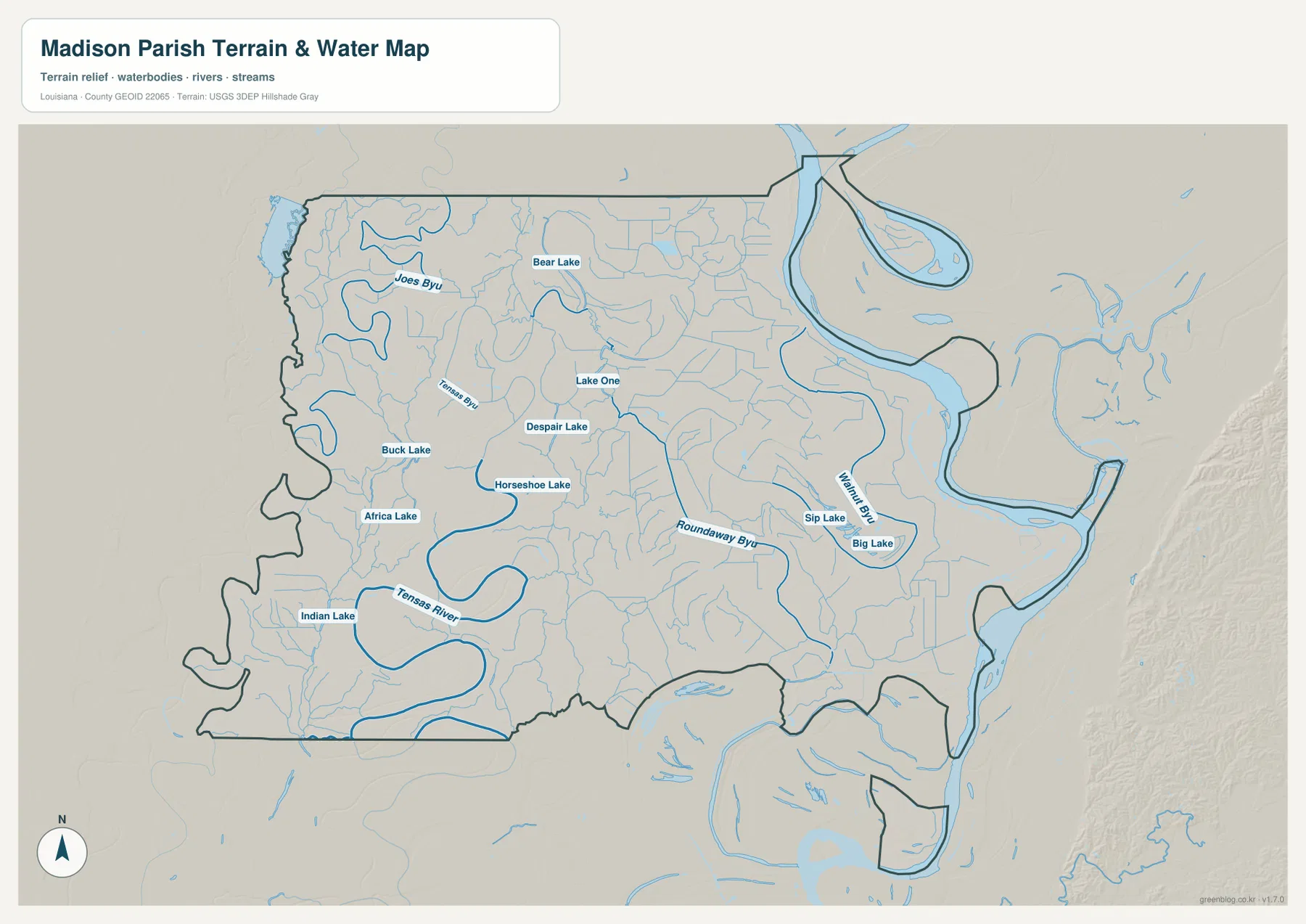
The terrain-and-water map reveals a dense drainage pattern that is easy to miss on the road-focused view. Tensas Bayou winds through the northwest, while the Tensas River makes broad curves across the southwest. Joe’s Bayou is also labeled in the northwest, and Roundaway Bayou stretches through the central part of the parish toward the east. Numerous smaller channels fill the spaces between these larger named waterways.
Several named lakes provide additional landmarks. Bear Lake and Lake One lie in the northern and central sections, while Despair Lake and Horseshoe Lake appear farther west of center. Buck Lake and Africa Lake are labeled in the west, and Indian Lake sits near the southwest. Together they show that Madison Parish contains a complex internal water system in addition to the much larger Mississippi River along its eastern edge.
Walnut Bayou, Big Lake, and Sip Lake distinguish the eastern lowlands
Closer to the Mississippi River, Walnut Bayou becomes one of the strongest named interior waterways. Sip Lake and Big Lake sit nearby, and Roundaway Bayou approaches the same general area from the west. Water features occupy a noticeably larger share of the landscape around Mound and Delta than around the western road network, which helps explain why the eastern half appears more closely tied to the river environment.
This terrain-and-water map is meant for geographic reference rather than hazard or navigation decisions. Blue areas do not by themselves indicate a flood-zone classification, navigable depth, levee protection, or a legal parcel boundary. Flooding, navigation, and property questions should be checked against current information from USGS and the responsible state or federal agencies.
Road landmarks work best around Tallulah; water landmarks become more useful away from town
A practical way to orient yourself is to begin with Tallulah and follow I-20 or U.S. 80 east toward Richmond, Mound, and Delta. From there, the Mississippi River provides a clear eastern reference. Moving west, numbered state roads such as LA 579, 577, and 610 become more useful because major town labels are less frequent. This change in reference points mirrors the parish’s shift from its main transportation corridor to more rural and water-crossed areas.
For hydrology, start with the Tensas River and Tensas Bayou in the west, Roundaway Bayou through the middle, and Walnut Bayou and the Mississippi River in the east. The general map works best when settlements, roads, and boundaries need to appear together. The ranked city graphic is cleaner for comparing the four selected communities, while the water map gives the named lakes and bayous enough space to be read without road labels competing for attention.
The original JPG files keep small road and water labels readable
The downloadable ZIP contains the three original JPG files corresponding to the previews on this page: the general parish map, the ranked city map, and the terrain-and-water map. Each original image is 3638 by 2572 pixels, providing more room to inspect route numbers, place names, lake labels, and the complicated river boundary than the web preview. The files are practical for printing, classroom material, presentation slides, and personal geographic reference.
Choose the general map for roads, settlements, and the parish outline; use the city index for a quick comparison of Tallulah, Richmond, Delta, and Mound; and use the water map when the Tensas River, Mississippi River, bayous, and lakes are the main subject. These are general reference maps rather than legal boundary, survey, flood-risk, or real-time navigation products.
Frequently Asked Questions
What is the parish seat of Madison Parish?
Tallulah is the parish seat. It is also the largest developed place shown on the supplied map and sits along the I-20 and U.S. 80 corridor. Richmond is immediately southeast of Tallulah, while Mound and Delta lie farther east toward the Mississippi River.
Do the numbers 1 through 4 on the city map represent distance?
No. They are rankings in the city index: Tallulah is 1, Richmond 2, Delta 3, and Mound 4. The graphic does not show driving or straight-line distance, so use the general map and current navigation information when mileage or travel time matters.
Can the Mississippi River and lake map be used as a flood-risk map?
No. The water map is a general reference showing the relative positions of the Mississippi River, Tensas River, bayous, and named lakes. It does not provide flood-zone ratings, water depth, navigability, levee-protection status, or legal property boundaries. Those decisions require current official hazard and jurisdiction data.
Map File Information
The ZIP contains the original high-resolution JPG files corresponding to the general parish map, ranked city map, and terrain-and-water map shown on this page.
- Included Files: parish map JPG, ranked city map JPG, terrain-and-water map JPG
Related Maps
Sources and references
For parish-seat and municipality information, see the Louisiana.gov Madison Parish Profile and the official Madison Parish website. General boundary data are documented by the U.S. Census Bureau TIGER/Line Shapefiles, and national water-feature data are documented through USGS National Hydrography.
Green Map creates custom-edited map images using open geographic data sources such as geoBoundaries, Natural Earth, OpenStreetMap, and government open data. These maps are edited visual materials, not raw data files, and are provided for education, documents, presentations, and graphic reference.