Clayton County lies in northeastern Iowa where the county meets the Mississippi River and a dense network of tributary valleys cuts across the interior. Elkader provides a useful inland reference point, while Guttenberg, McGregor, Marquette, and Clayton sit close to the river on the eastern side. Monona and Strawberry Point lie farther inland, so the maps show a clear contrast between river towns, rolling uplands, and the deeply incised valleys of the Turkey River system. This page explains those features from the supplied county, city, water, and elevation maps, and the same map set is available below as high-resolution JPG files in a downloadable ZIP archive.
The easiest way to understand the county is to begin with two landmarks: the Mississippi River on the east and the Turkey River crossing the interior. Once those are located, the road map shows how communities connect across the county, while the terrain-and-water map reveals the narrow valleys hidden beneath a simpler road view. The elevation map adds another layer by showing low river corridors against much higher ridges and uplands. A separate city map reduces the detail and highlights six major communities, making it a good orientation tool before returning to the more detailed maps.
Table of Contents
The Mississippi River defines a long and irregular eastern edge
The eastern side is the strongest visual feature on the general county map. The Mississippi River runs past Marquette and McGregor in the northeast, continues south past Clayton and Guttenberg, and remains the dominant reference along the county’s eastern edge toward North Buena Vista. The county boundary follows the river’s bends rather than a simple straight line. Backwaters and wider river reaches also make this side of the county look very different from the more regular western and southern edges.
Roads approach the river from several directions. Iowa 76 runs along the northeast river corridor near Marquette and McGregor, while U.S. 18 comes in from the west toward McGregor. Farther south, routes from Elkader and Garnavillo descend toward Guttenberg and the Mississippi. This pattern is useful for trip planning because it separates two kinds of movement: roads that follow the river corridor and roads that cross the interior to reach it. The map is not a live navigation product, but it gives a clear first look at the county’s major travel directions.
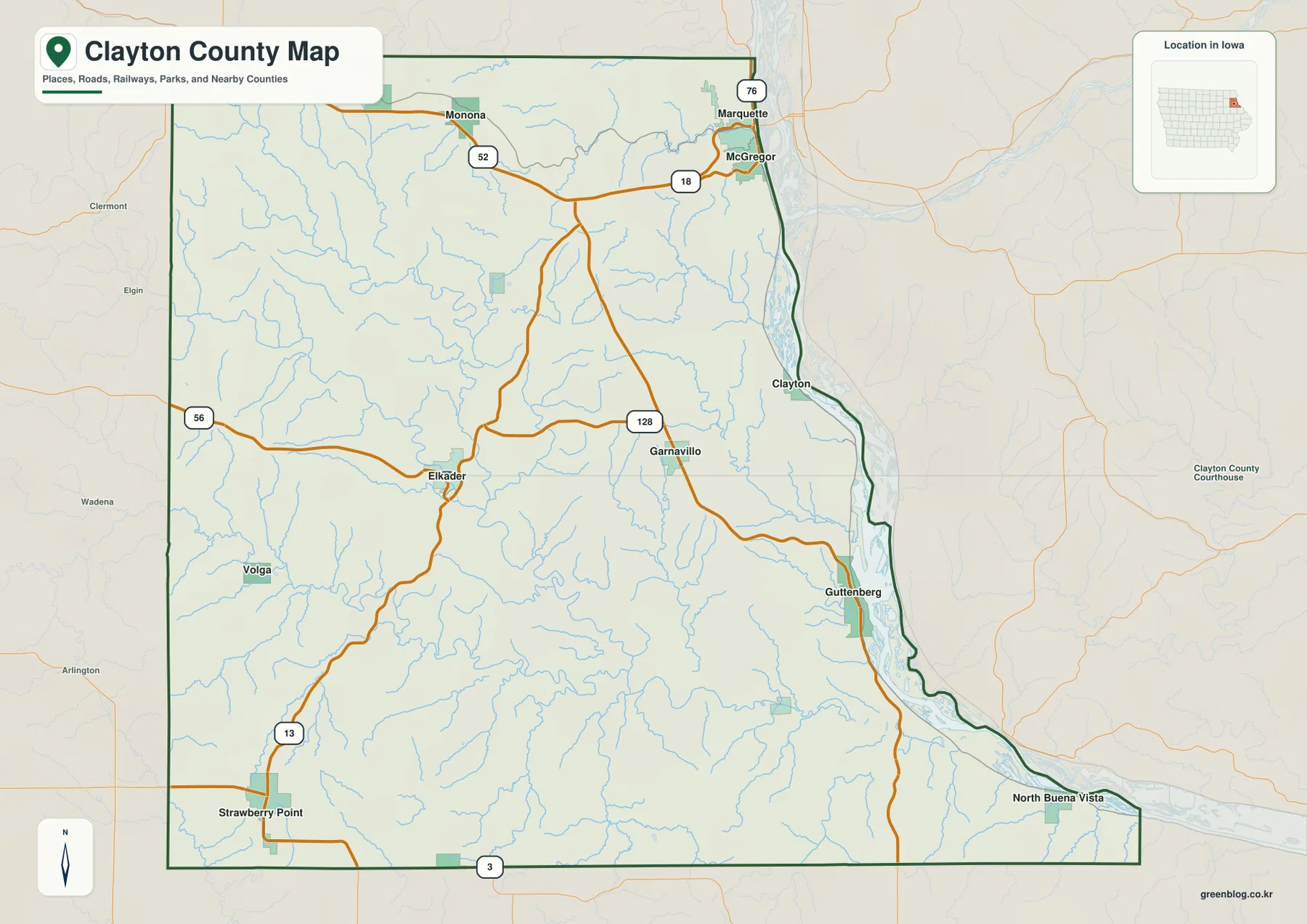
Use this general map for orientation rather than legal or real-time decisions. County lines on a reference map do not substitute for parcel surveys, and road conditions can change because of construction, closures, weather, or maintenance. For those tasks, current transportation and land-record sources should take priority. The map is most useful when you want to learn where communities sit, which highways link them, and how the river side of the county differs from the inland side.
Elkader works as an inland anchor for roads and nearby communities
Elkader sits a little west of the county’s center and is the current county seat, according to Clayton County’s official history. On the map, Iowa 13 reaches Elkader from the Strawberry Point direction, while Iowa 56 approaches from the west. Other roads continue north and east toward Monona, Garnavillo, and the Mississippi River communities. Starting with Elkader makes the road network easier to understand because several different parts of the county can be described from this one reference point.
Monona appears in the northwestern part of the county near U.S. 52, while U.S. 18 crosses farther east toward McGregor. Garnavillo is east of Elkader and close to Iowa 128, and Guttenberg lies farther east on the Mississippi. Strawberry Point is near the southwest corner along Iowa 13 and close to Iowa 3 at the southern edge. These locations make more sense when read as directions from Elkader rather than as a list of separate place names.
The county’s official history also explains why Elkader appears repeatedly as an administrative reference. Clayton County’s seat moved among several communities during the nineteenth century before Elkader ultimately secured the role. That history is not necessary for reading the maps, but it adds context to the present-day pattern: Elkader remains an important inland center, and the road map shows it connected to both western communities and the Mississippi side of the county.
Six major communities show the split between river towns and inland towns
The city map highlights Guttenberg, Monona, Elkader, Strawberry Point, Garnavillo, and McGregor. Guttenberg and McGregor sit close to the Mississippi River, while Monona is farther northwest in the interior. Elkader occupies a more central inland position, Garnavillo lies between Elkader and the river, and Strawberry Point is well to the southwest. Because the map removes much of the smaller road detail, the broad settlement pattern is easier to see than it is on the general county map.
Neighboring areas also help establish orientation. Allamakee and Winneshiek Counties are labeled to the north, Fayette County to the west, Delaware County to the southwest, and Dubuque County to the southeast. Wisconsin lies across the Mississippi River to the east. These labels make Clayton County’s northeastern Iowa location immediately clear, but they should be treated as context rather than a substitute for an authoritative boundary dataset.
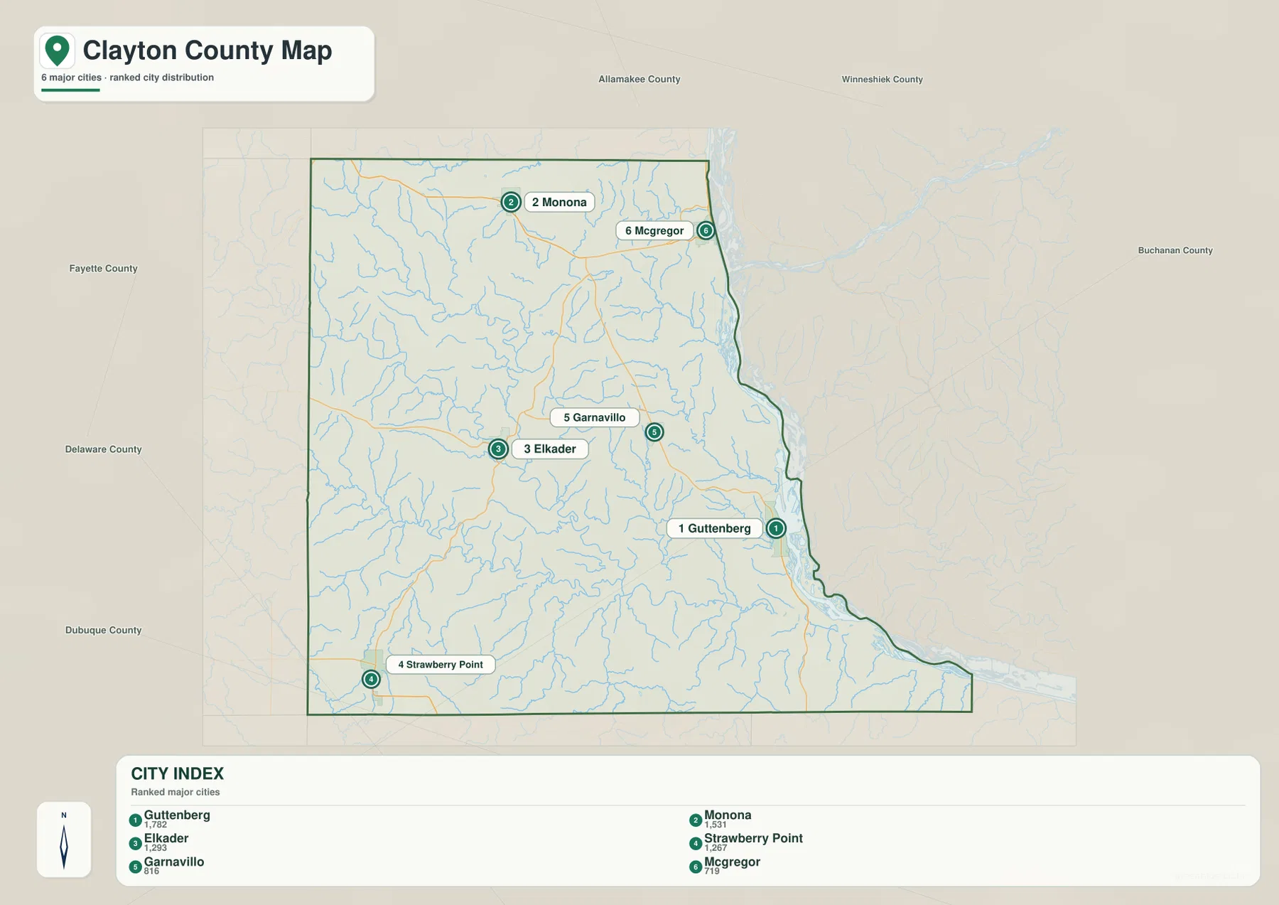
After learning the six city locations, return to the general map to connect them to roads. U.S. 18 provides an important east-west approach toward McGregor, Iowa 13 links the Strawberry Point and Elkader areas, and routes around Garnavillo lead toward Guttenberg. The two maps complement each other rather than duplicate the same information: one simplifies the settlement pattern, while the other shows the roads and smaller geographic features needed for a fuller picture.
Turkey River and Volga River valleys cut deeply through the interior
The terrain-and-water map makes the Turkey River the central natural feature of the county. It enters from the west, bends repeatedly across the interior, and continues toward the lower eastern side where the landscape drops toward the Mississippi. The river corridor is narrow in many places, and shaded relief shows steep slopes rising quickly on both sides. That appearance is very different from a flat road map and helps explain why the county has so many winding valleys.
Several named tributaries add detail. The Volga River comes in from the southwest and joins the broader Turkey River system, while Roberts Creek descends from the northwest. The Little Turkey River approaches from the south, and Buck Creek drains part of the eastern interior. Dry Mill Creek and other smaller streams branch through the uplands. Together they create a dense network of narrow valleys that breaks the county into ridges, slopes, and river bottoms rather than one continuous flat surface.
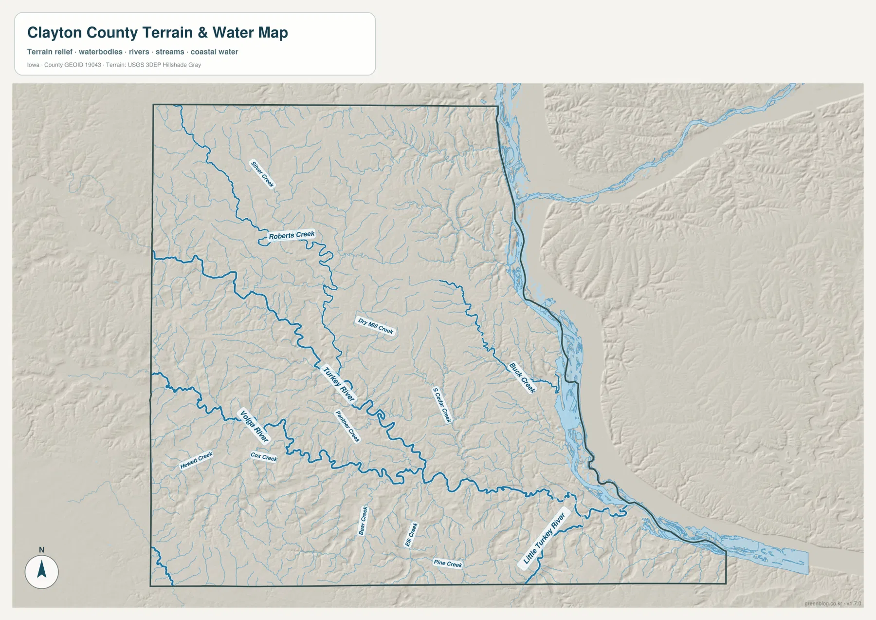
This is a geographic reference map, not a flood, depth, navigation, or property-rights product. Blue lines are useful for locating rivers and streams, but they do not show current water level, flood probability, channel depth, or boating conditions. Anyone making a floodplain, engineering, or on-water decision should use current information from the appropriate federal, state, or local agency. For ordinary map reading, however, the water layer is excellent for seeing how the county’s communities and roads sit among valleys.
An elevation range of 184–388 meters reveals steep river bluffs and high uplands
The supplied elevation map shows an actual county range of about 184 to 388 meters, with a mean of 298 meters. The lowest greens follow the Mississippi River along the eastern edge and extend inland along the Turkey River and other major valleys. Similar low corridors trace the Volga River and Little Turkey River. Even without place labels, those green ribbons make the drainage network easy to recognize because the valleys align closely with the streams shown on the water map.
Higher brown and tan ground occupies much of the land between those valleys. The western and northwestern uplands are broad, but high ridges also remain between the branches of the Turkey River system. Near the Mississippi, elevation can change quickly over a short horizontal distance as the low river corridor meets steep bluffs. For that reason, Clayton County is better described as a landscape of repeated ridges and valleys than as a simple west-high, east-low slope.
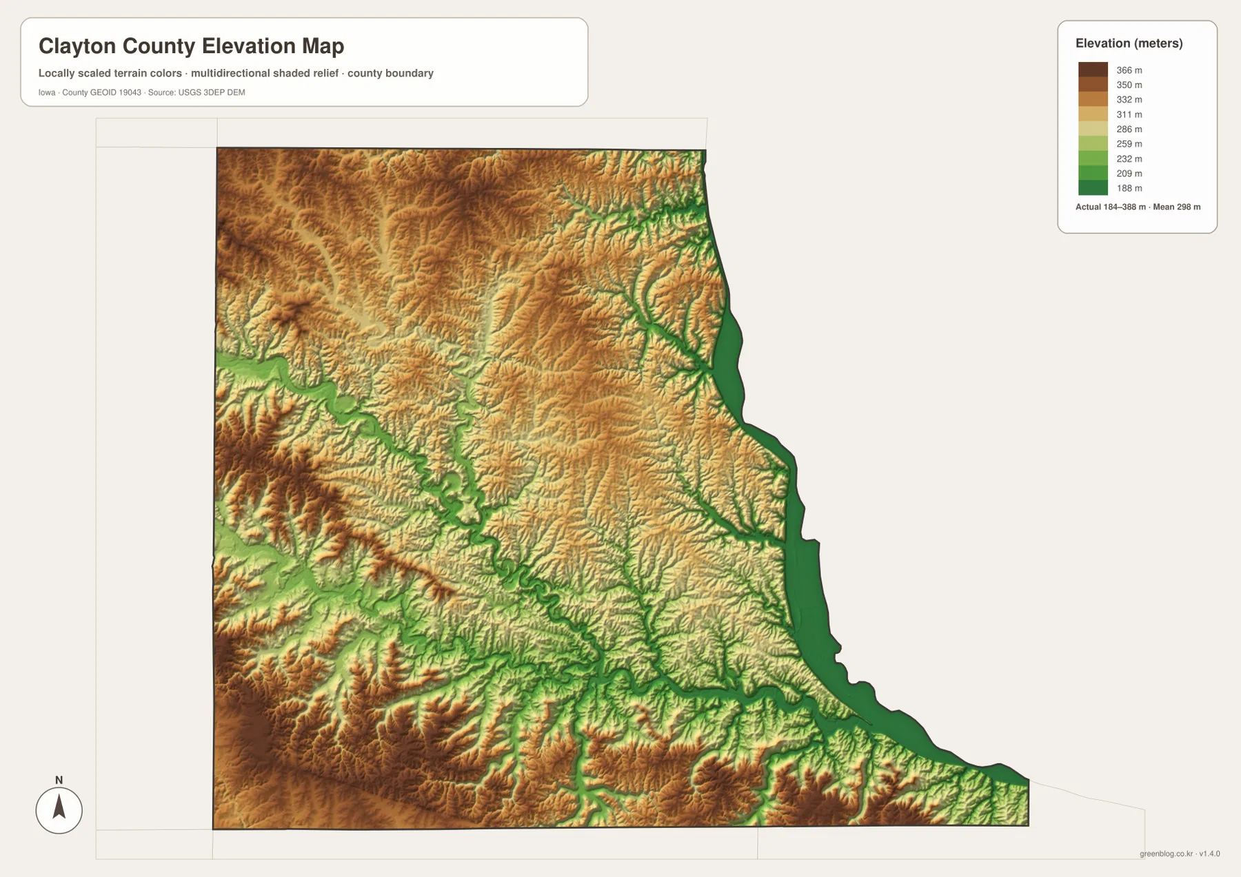
Iowa DNR’s description of Turkey River Mounds State Preserve provides a useful real-world example of this eastern terrain. The preserve is southeast of Guttenberg on a narrow ridge above the meeting area of the Turkey and Mississippi Rivers, and the agency describes bluffs rising roughly 250 feet above the Mississippi floodplain. That helps explain the sharp color changes visible near the eastern river corridor. The county elevation map is still a generalized reference surface, though, and should not be used for site-specific engineering, construction, or survey-grade measurements.
McGregor and Guttenberg occupy a different setting from Elkader and Monona
Comparing the city and elevation maps shows why the eastern river towns stand apart. McGregor and Guttenberg are close to the Mississippi’s low corridor, with steep higher ground rising immediately inland. Elkader, by contrast, sits within the Turkey River valley system, where low ground threads through uplands from several directions. Monona and Strawberry Point are farther onto the interior uplands and do not sit directly against the broad Mississippi corridor. These differences are visible without needing a separate geological map.
Garnavillo is especially useful as a middle reference between Elkader and Guttenberg. Moving east from Garnavillo leads toward the Mississippi River and the lower river margin, while moving west leads back toward Elkader and the Turkey River valleys. Thinking in these geographic steps is often more memorable than reading a list of towns. It also shows why road routes bend and change direction: the network has to connect communities across a landscape cut by rivers and ridges.
The northeast corner around McGregor and Marquette offers another clear example. U.S. 18 and Iowa 76 approach the Mississippi corridor while steeply dissected terrain lies immediately to the west. The map cannot tell you the exact road grade or driving difficulty, but the relationship between roads, river, and relief explains why routes are less regular than they might be on flatter ground. For travel orientation, looking at the road and elevation maps together is more informative than relying on either one alone.
Choose the map according to the question you need to answer
For a first look at Clayton County, start with the general map and locate Elkader, the Mississippi River, and the major highways. From there, follow U.S. 18 toward McGregor, Iowa 13 between Strawberry Point and Elkader, and the roads that continue east toward Garnavillo and Guttenberg. This gives you a working framework for the county before adding the denser network of streams and terrain.
If your main goal is to compare communities, the city map is faster because it emphasizes six major locations and removes much of the minor detail. If you want to understand why the eastern side and the Turkey River corridor look so rugged, use the terrain-and-water map next. Finally, the elevation map translates that ruggedness into a clear height pattern: green river bottoms, higher tan and brown uplands, and steep transitions near the Mississippi bluffs.
The water and elevation maps are especially useful together. The Turkey River, Volga River, and their tributaries on the water map align with low corridors on the elevation map, while ridges occupy the spaces between streams. This comparison gives a more complete picture of how the county is shaped than a road map alone can provide. For technical work, however, use the original USGS hydrography and elevation datasets rather than treating these overview images as engineering-grade sources.
High-resolution JPG files are available for print and offline use
The WebP images in the article are sized for convenient browser viewing. If you need larger files for printing, classroom material, presentations, trip preparation, or offline reference, the ZIP below contains the high-resolution JPG versions of the county map, major-city map, terrain-and-water map, and elevation map. Each file is separate, so you can use only the map that fits your task or keep all four for comparison.
The downloadable files remain reference maps. They should not replace current official sources for legal boundaries, parcel ownership, flood regulation, road closures, water conditions, or precise elevations. This matters particularly in Clayton County because river valleys and steep bluffs create large local differences that a county-scale image necessarily simplifies. For planning that depends on present conditions or exact measurements, verify the information with the responsible agency.
Frequently Asked Questions
Which map best shows the Mississippi bluffs and the Turkey River valley together?
Use the terrain-and-water map first to locate the Mississippi River, Turkey River, Volga River, and the smaller tributaries. Then compare it with the elevation map. The same river corridors appear as lower green areas, while the surrounding ridges rise into tan and brown colors. The pair makes the steep eastern bluffs and the deeply cut interior valleys much easier to understand.
What is the easiest way to orient from Elkader toward Guttenberg or McGregor?
Start with the general county map. Locate Elkader, then follow the road network east toward Garnavillo and Guttenberg, or northeast toward the U.S. 18 corridor leading to McGregor. If the community locations are unfamiliar, check the city map first; it highlights Elkader, Garnavillo, Guttenberg, and McGregor with less surrounding detail.
Where does the elevation map show the lowest and highest terrain?
The supplied map covers roughly 184–388 meters. The lowest colors follow the Mississippi River and major valleys such as the Turkey and Volga Rivers. Higher colors cover the ridges and uplands between those valleys. Near the Mississippi, the transition can be especially abrupt because low river land sits close to steep bluffs and higher interior ground.
Map File Information
Download the high-resolution JPG versions of the general county map, major-city map, terrain-and-water map, and elevation map shown on this page in one ZIP archive.
- Included Files: 4 high-resolution JPG maps
Related Maps
Sources and references
These official sources are useful for checking Clayton County background information and the boundary, hydrography, and elevation datasets represented by the maps.
- Clayton County, Iowa – official county information
- Iowa DNR – Turkey River Mounds State Preserve
- U.S. Census Bureau TIGER/Line Shapefiles
- USGS National Hydrography
- USGS 3D Elevation Program
Use the maps on this page as geographic reference material. For current legal boundaries, road conditions, flood regulation, parcel ownership, or precise elevation measurements, consult the latest records and datasets from the responsible agency.
Green Map creates custom-edited map images using open geographic data sources such as geoBoundaries, Natural Earth, OpenStreetMap, and government open data.
These maps are edited visual materials, not raw data files, and are provided for education, documents, presentations, and graphic reference.