A Salto map provides a clear way to compare the departmental capital with six municipality areas distributed across northwestern Uruguay. The supplied images identify Salto city together with Belén, Villa Constitución, Colonia Lavalleja, Valentín, San Antonio, and Mataojo. These places are spread from the western edge to the far eastern side of the department, so their positions are easier to understand through boundaries than through a simple list of names.
Salto Department lies in northwestern Uruguay. It borders Artigas to the north, Rivera and Tacuarembó to the east, and Paysandú to the south. The Uruguay River separates its western side from Argentina. Those neighboring departments, Argentine territory, the river course, and riverbank details are not included as separate elements in the downloadable images, which focus on Salto’s internal administrative layout.
The department covers approximately 13,981 square kilometers and has a reported population of 133,197. Salto city is the departmental capital and appears near the western edge, while Belén and Villa Constitución occupy northwestern areas. Colonia Lavalleja stretches across the north-central section, Valentín sits near the center, San Antonio lies close to the capital, and Mataojo forms a broad eastern municipality.
The Salto map collection includes outline, black and white, and color versions supplied as WEBP image files. The outline file provides a blank working base, the monochrome file adds names and boundaries, and the color version makes differences in municipal size and position easier to compare. Teachers, students, bloggers, presentation creators, and infographic designers can select the format that fits their project without changing the underlying departmental layout.
Table of Contents
Reading the Salto Map Layout
Salto Department extends broadly from west to east, but its six municipalities do not form a single continuous administrative block. Belén and Villa Constitución are relatively close in the northwest, while Colonia Lavalleja continues across the north-central area. Valentín occupies a separate central polygon, and Mataojo stands apart as a large eastern municipality.
Salto city is represented by a black point and label rather than a filled municipality polygon. San Antonio lies near the capital but has its own bounded territory, making it important to distinguish the city marker from the neighboring municipal area. The visual treatment helps readers understand that a departmental capital and a municipality are not necessarily represented in the same way.
Large areas remain outside the six named municipality polygons. These spaces are not missing divisions or mistakes in the artwork. Salto Department is not completely divided among only the six municipalities shown, so the remaining departmental territory appears as an unlabelled background area. The departmental government lists Belén, Colonia Lavalleja, Mataojo, San Antonio, Valentín, and Villa Constitución as its municipalities.
Municipalities Included in the Files
Belén
Belén occupies a relatively small area at the northwestern end of the department. Its long, narrow shape sits above Villa Constitución and is visually separated from the wider northern territory.
Because Belén is compact, its boundary can become difficult to recognize when the image is reduced. The labeled and color versions are the clearest choices for presentation slides or classroom references where the municipality must remain easy to locate.
Villa Constitución
Villa Constitución covers a broad northwestern section below and east of Belén. Its boundary extends toward Colonia Lavalleja, creating a wider and more irregular polygon than the municipality immediately to its north.
The proximity of Belén and Villa Constitución may make them appear to belong to one local area at first glance. Their separate labels and boundary lines make the administrative distinction clear.
Colonia Lavalleja
Colonia Lavalleja extends across the north-central part of Salto Department. Its long east–west form places it between the northwestern municipalities and Mataojo in the east.
This position makes Colonia Lavalleja an important reference when reading the department from left to right. It also borders the area around Valentín to the south, creating one of the more complex internal boundary sections in the map.
Valentín
Valentín appears near the center of the department. Its polygon is narrower than the surrounding unmunicipalized territory and tapers toward the lower part of the map.
The official departmental municipality page currently uses the name Valentín. The shorter label also matches the wording visible in the supplied images.
San Antonio
San Antonio is located near Salto city in the western part of the department. Its compact and irregular polygon contrasts with the much larger areas of Villa Constitución, Colonia Lavalleja, and Mataojo.
The municipality’s location close to the capital can cause confusion in a simplified location list. On the map, Salto is marked by a point, while San Antonio is shown as a separate bounded area.
Mataojo
Mataojo occupies the large eastern section of the department. It is the most visually dominant named municipality and is separated from the western cluster by broad areas and complex internal boundaries.
Its size creates a strong contrast with Belén and San Antonio. This difference is one of the clearest reasons why a visual resource is more useful than a written list for explaining Salto’s municipal structure.
Blank Outline Base for Custom Work
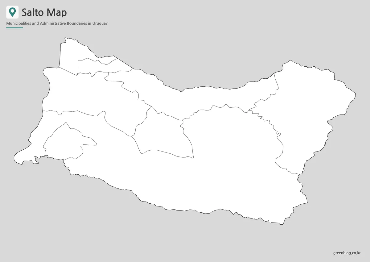
The outline Salto map removes all labels and color fills while retaining the departmental shape and internal municipal boundaries. It works as a practical base for writing place names, assigning colors, adding statistics, or creating location exercises.
Students can identify the six municipalities from a reference sheet and then complete the blank version independently. Designers may add population data, agriculture information, symbols, arrows, or presentation notes without covering existing text.
The outline image does not include surrounding departments, Argentina, the Uruguay River, roads, or tourist locations. Any of those elements would need to be added from a separately verified source.
Black and White Version for Reference Sheets
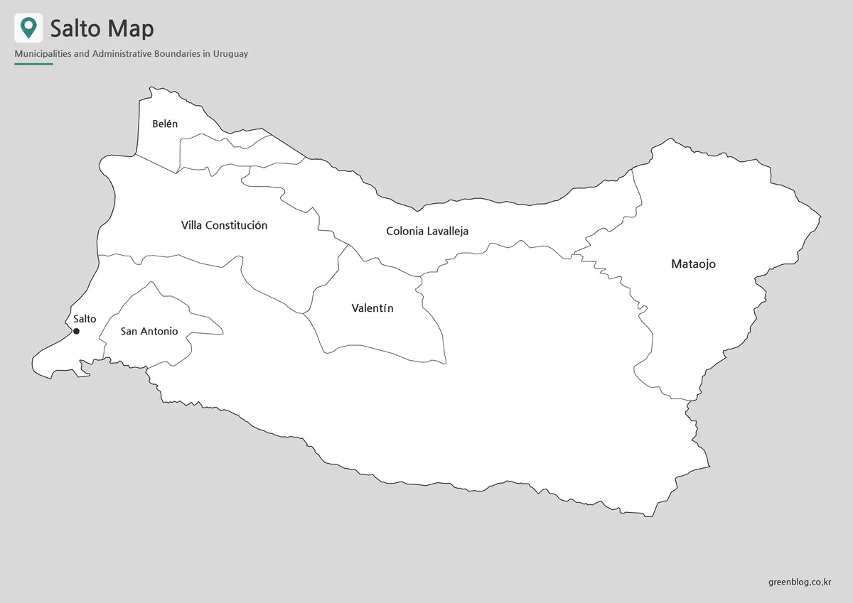
The black and white Salto map adds the capital and six municipality names while keeping the overall appearance simple. Its open background and thin boundary lines fit reports, photocopied worksheets, assignment pages, and other documents where color is unnecessary.
Northern labels such as Belén, Villa Constitución, and Colonia Lavalleja can be read as a sequence, while Valentín and Mataojo remain clearly separated toward the center and east. Salto city appears as a point, making it easy to distinguish from San Antonio’s polygon.
This version is particularly useful as an answer sheet paired with the blank outline. It also works well in a collection where several Uruguayan department maps need the same monochrome appearance.
Color Version for Comparing Municipal Size
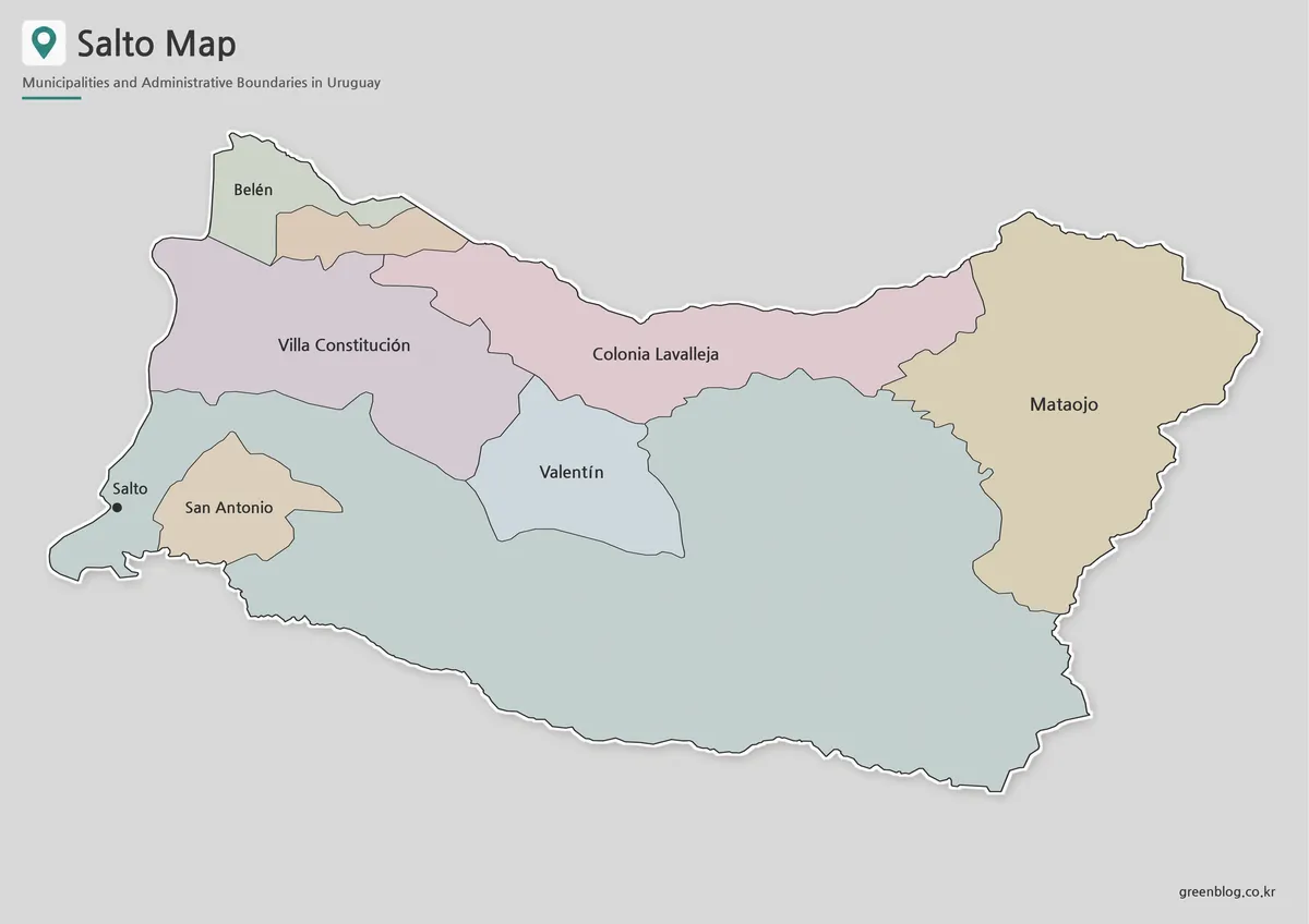
The color Salto map separates each named municipality with a different fill. This makes the contrast between compact Belén and San Antonio, elongated Colonia Lavalleja, central Valentín, and broad Mataojo immediately visible.
Villa Constitución’s position below Belén and beside Colonia Lavalleja is also easier to interpret with color. Since the municipality areas are widely distributed rather than tightly clustered, the color treatment gives presentation viewers a faster overview.
The background color represents the rest of Salto Department and should not be interpreted as another named municipality. The fills also do not represent population, land use, tourism, or natural landscapes.
Practical Uses for the Map Collection
Teachers can combine the three files into a simple learning sequence. The labeled map introduces the names, the color version supports visual comparison, and the outline file can be used for a quiz, coloring task, or regional annotation exercise.
For presentations, the color file works well on an introductory slide where viewers need to grasp the layout quickly. The black and white version is better suited to printed notes, while the outline image provides space for custom statistics or highlighted project areas.
Bloggers and video creators can use the images when introducing the administrative structure of northwestern Uruguay. However, the collection should not be described as a road, river, tourism, or international-border map because those features are not displayed.
Frequently Asked Questions
What areas are shown on the Salto map?
The labeled versions show Salto city and the municipalities of Belén, Villa Constitución, Colonia Lavalleja, Valentín, San Antonio, and Mataojo.
Are Argentina and the Uruguay River included?
No. Salto Department borders Argentina across the Uruguay River, but neither Argentine territory nor a separately identified river layer appears in the supplied files.
Why are parts of the department not colored as municipalities?
The six municipalities do not cover the entire department. The remaining space represents departmental territory outside their boundaries.
Which file is best for classroom activities?
Use the black and white version as a reference and the outline file for writing, coloring, quizzes, or custom annotations.
What can be added to the outline version?
Users can add municipality names, population figures, agriculture data, project symbols, arrows, and presentation highlights.
Download Information
Map File Information
This download includes printable Salto map versions for educational use, presentation design, document printing, and editable graphic projects.
- Included Versions: Outline map, black and white map, color map
- File Type: WEBP image files
- Displayed Areas: Salto, Belén, Villa Constitución, Colonia Lavalleja, Valentín, San Antonio, and Mataojo
- Intended Use: Classroom handouts, presentations, blog graphics, regional comparisons, infographic editing, and printable reference materials
Related Maps
Additional Resources
- Salto – Uruguay Natural : The official tourism page introduces Salto city, its thermal attractions, cultural sites, and regional visitor information.
Green Map creates custom-edited map images using open geographic data sources such as geoBoundaries, Natural Earth, OpenStreetMap, and government open data. These maps are edited visual materials, not raw data files, and are provided for education, documents, presentations, and graphic reference.