A Brunei Map must explain an unusual national shape before it can serve as a useful district reference: Brunei Darussalam occupies two separate areas on Borneo’s northwestern coast. Belait, Tutong, and Brunei-Muara form the western section, while Temburong lies farther east with Malaysian territory between them. The three supplied views keep that separation visible in color, black and white, and blank outline form.
Rather than crowding the page with roads, rivers, towns, or terrain, the images concentrate on four first-level administrative districts. The labeled versions also provide Malaysia and South China Sea context, while the outline edition removes geographic names for independent labeling. This focused scope makes the set practical for geography lessons, country profiles, presentation slides, report graphics, and uncomplicated district-comparison activities.
All three previews use the same 1200 × 849 landscape composition and are identified as an A3 layout. A consistent frame lets a teacher move from reference to worksheet without changing the country geometry, or allows a designer to compare treatments before choosing one. The Brunei Map archive contains image-based resources; it does not claim to provide editable vector boundaries or a navigation-ready geographic dataset.
Table of Contents
Brunei Map Overview
Brunei Darussalam covers 5,765 square kilometres and has 161 kilometres of coastline, according to the country’s Information Department. It faces the South China Sea and shares its land boundary with Malaysia. Bandar Seri Begawan is the capital, but the supplied artwork does not plot a capital symbol or city network, so the page should be read as an administrative overview rather than an urban map.
The western section follows a clear district sequence. Belait occupies the broad western end, Tutong sits immediately to its east, and Brunei-Muara reaches the northeastern coast of that section. Brunei-Muara is visually smaller than the other western districts, yet its indented coast and offshore shapes receive enough room to remain recognizable in the enlarged layout.
Temburong appears as a detached eastern area because Malaysia’s Sarawak lies between it and Brunei-Muara. The gap is not a missing district, an inland lake, or unused white space within Brunei. Keeping it at a realistic separation is essential: moving Temburong beside the western chain would make the composition more compact but would erase the country’s defining geographic relationship.
This two-part structure is the main reason a dedicated Brunei Map communicates more effectively than a small Southeast Asia overview. The district names can be placed inside their boundaries, the Malaysian interruption can remain visible, and the coast can be shown without reducing Brunei-Muara to an unreadable sliver.
Included Map Versions
The set changes visual guidance while preserving administrative coverage. Each image includes the same national outline, the two-section arrangement, and boundaries between Belait, Tutong, and Brunei-Muara. The title and “Administrative Boundaries” subtitle remain visible even on the outline sheet, so the blank edition is unlabelled geographically rather than completely text-free.
- Color map: four named districts use separate muted fills, with blue water and gray surrounding land.
- Black-and-white map: district, country, and sea labels remain while Bruneian interiors become white.
- Outline map: district and surrounding labels are removed, but national and district boundary lines remain.
No version includes mukim divisions, settlements, highways, relief, scale measurements, or thematic values. That omission is deliberate and useful when the goal is first-level district orientation. A project requiring current road access, precise distance, lower-level administration, or legal boundary analysis should pair these illustrations with an appropriate government or specialist source.
Color Administrative Map
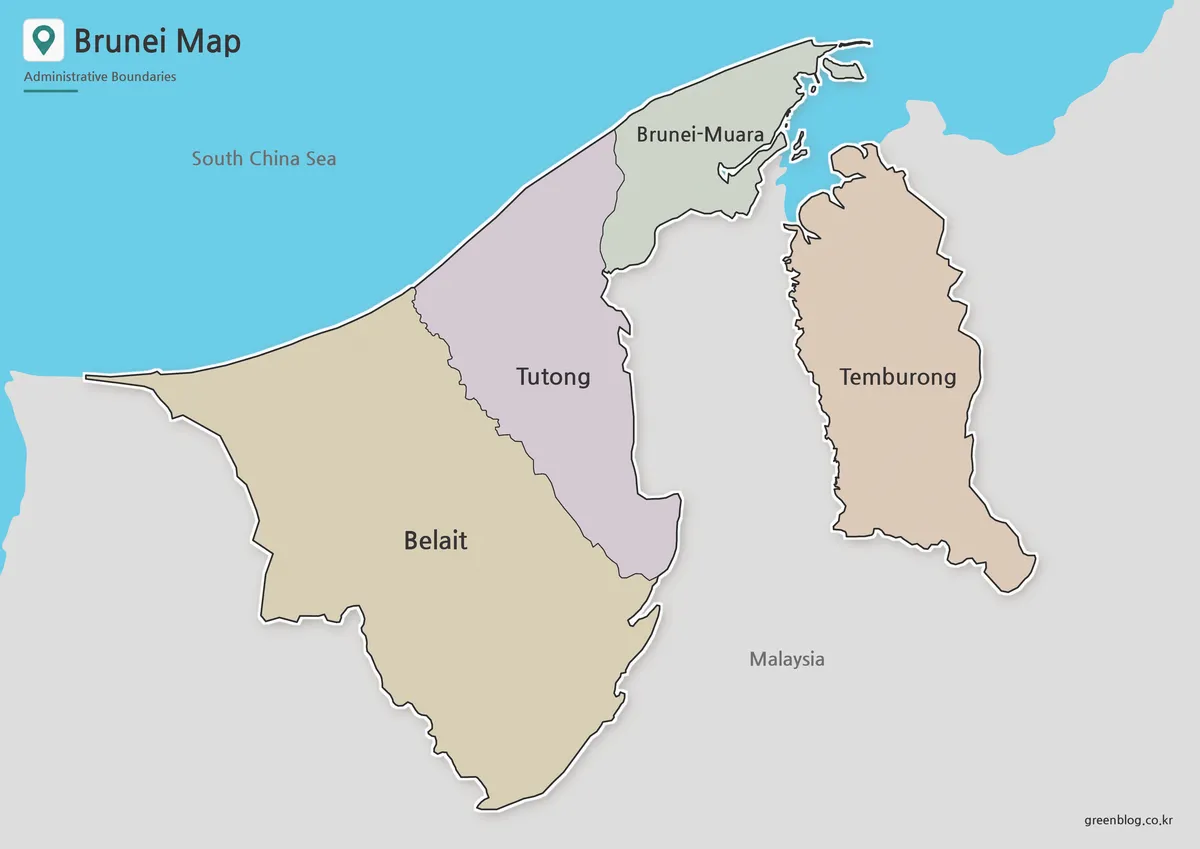
The color Brunei Map assigns a different pale fill to each district: beige for Belait, muted purple for Tutong, pale green for Brunei-Muara, and light brown for Temburong. These colors function only as separators. Because the image supplies no thematic legend, the palette must not be interpreted as population, elevation, land use, economic output, or any other statistical category.
Color makes the western sequence especially easy to follow. The broad Belait area narrows toward Tutong, Tutong reaches the irregular inner boundary beside Brunei-Muara, and the green northeastern district meets the coast. Temburong’s separate brown fill reinforces that it belongs to the same four-district framework even though gray Malaysian territory interrupts the national land area.
This edition works best when an audience needs instant orientation, such as an opening classroom slide, a country-profile graphic, or a blog illustration. The blue South China Sea supplies a strong coastal reference, and the gray surrounding land prevents Brunei’s sections from appearing to float. If the finished document will be photocopied, however, similar pastel tones may collapse into comparable grays, so the dedicated monochrome file is safer.
Black and White Printable Version
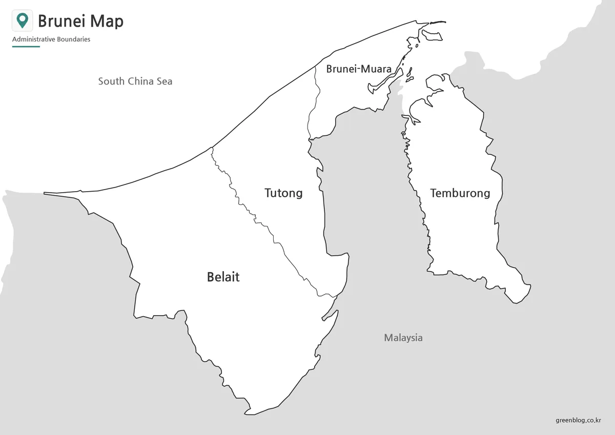
The monochrome edition preserves Belait, Tutong, Brunei-Muara, and Temburong labels, together with Malaysia and the South China Sea. Bruneian territory is white, neighboring land is gray, and black lines carry the administrative structure. Without colored district fills, it can sit beside charts or body text without competing with a document’s existing visual scheme.
Open district interiors create useful writing space. Students can number the west-to-east order, circle the detached district, add a capital marker after consulting a reliable source, or shade selected areas according to an assignment. The labels remain available as guidance, making this version better for annotation than for a memory test.
For A3 output, choose landscape orientation and preserve the image proportions. Before printing a class set, check one proof for the smaller northeastern coastline, internal lines, and the space around Temburong. When reducing the Brunei Map to A4 or a narrow report column, avoid stretching it to fill the page because distortion changes the visual relationship between the separated sections.
Blank Brunei Outline Map for Editing
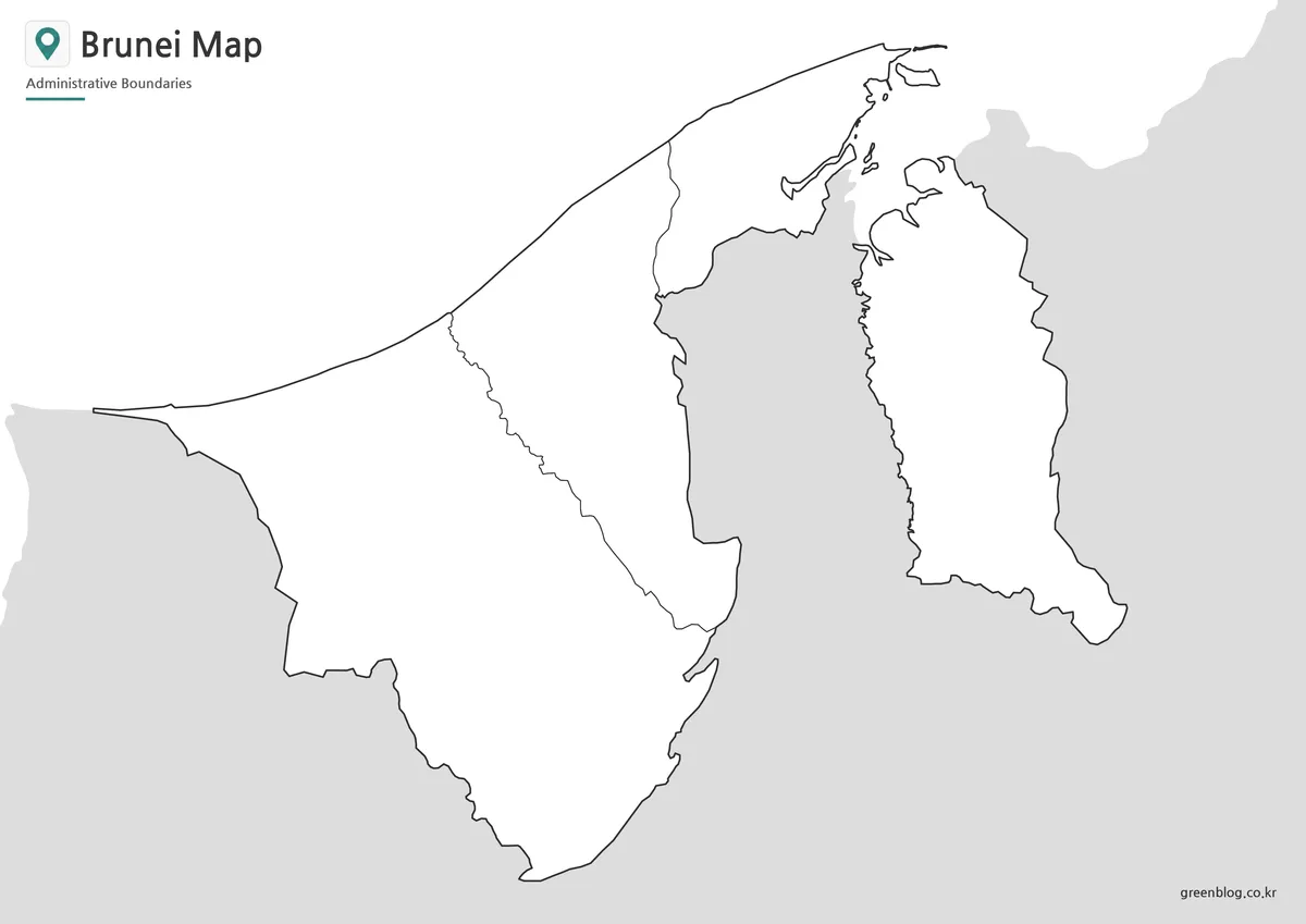
The outline Brunei Map removes all district names along with the Malaysia and sea labels. It retains the external country edges, the two internal divisions within the western section, and the detached Temburong outline. Gray surrounding land still indicates that the central gap lies outside Brunei, an important visual clue for learners encountering the shape for the first time.
A labeling exercise can begin with Belait at the broad west end, continue through Tutong, place Brunei-Muara on the northeastern coast of the western section, and finish with Temburong to the east. The color or black-and-white sheet can serve as a reference or answer page. Teachers can also ask learners to identify Malaysia and the South China Sea in the open surrounding areas.
For an infographic, work on a duplicate so the clean source remains available. Add short labels, maintain strong contrast, and provide a legend whenever new colors represent data rather than district identity. The outline is suitable for worksheets and simple visual explanations, but its raster image boundaries are not intended for surveying, parcel analysis, or precise spatial measurement.
Practical Uses for This Brunei Map
Choose the Brunei Map version according to how much guidance the final page should give. Color is strongest for rapid district recognition and projected display; black and white suits economical handouts with labels; outline creates a genuine labeling or categorization task. Treating the three files as stages of one lesson is often more effective than selecting them only by appearance.
A classroom sequence might introduce the two-section country with the color image, use the monochrome sheet for notes about district order, and end with the outline for recall. Students can then explain why Temburong lies apart instead of merely memorizing four names. Because every version shares the same geometry, attention stays on the learning task rather than on differences between map sources.
Presentation designers can use a labeled Brunei Map for regional orientation, then add one or two callouts in the open sea or Malaysian context areas. Keep annotations away from Brunei-Muara’s narrow coastal shapes and do not imply that a hand-drawn route is navigationally precise. For data graphics, cite the source and date separately because the supplied district colors carry no values of their own.
Frequently Asked Questions
What districts are shown on the Brunei map?
The Brunei map shows the four first-level districts: Brunei-Muara, Belait, Tutong, and Temburong.
Can I print this map in A3 size?
Yes. The map collection is prepared for A3 layout, making it suitable for classroom printing, presentation reference, and larger visual materials.
Which version should I use for editing?
The outline map is the best choice for editing. It keeps the country outline and internal district boundaries while leaving space for custom labels, colors, and markers.
Why does Temburong appear separated?
Temburong is geographically separated from Brunei’s western districts by Malaysian territory. That is why it appears apart from Brunei-Muara, Tutong, and Belait.
Is the Brunei map suitable for classroom use?
Yes. The black and white version works well for worksheets, while the color and outline versions can support lessons, assignments, and visual presentations.
Download Information
Map File Information
The archive contains three district-map images for printing, reference, labeling, and simple visual projects.
- Included Versions: Color, black and white, outline
- Printable Size: A3 layout
- File Type: Image files
- Intended Use: Lessons, handouts, presentations, labeling, and infographic work
Related Maps
Additional Resources
- About Brunei Darussalam — The official Information Department page explains the country’s area, coastline, capital, districts, and separated western and eastern sections.
Green Map creates custom-edited map images using open geographic data sources such as geoBoundaries, Natural Earth, OpenStreetMap, and government open data.
These maps are edited visual materials, not raw data files, and are provided for education, documents, presentations, and graphic reference.